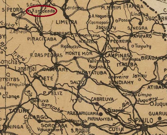
Villiers de l’Ile Adam: Carta (…) das Provincias dp Grão-Pará e Alto Amazonas, 1850
Other names: Equador, Sto. Antonio de Aruãs
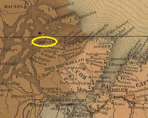
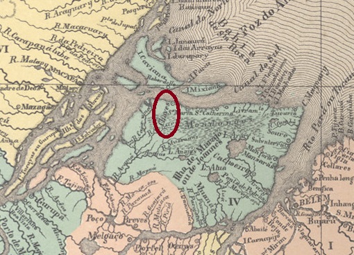
According to tradition, this place was also named after a Portuguese community. Although Santo Antonio de Chaves is in the province of Pará just 220 km north-west of the provincial capital Belém, the journey there today still takes 2 days and 10 hours for 500 km. Chaves was already a Vila in July 1755, which was renamed Equador in August 1834. This name was probably not well received, as the old name returned just ten years later. In January 1891, the locality was elevated to town status. In June 1932, titwas renamed Sto. Antonio de Aruãs, which was also not well received. The name Chaves returned definitively in October 1938.
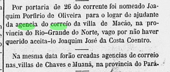
As the Rio press reported, there had been a post office in the town since April 1865:
Correio Mercantil/RJ, 28/04/1865
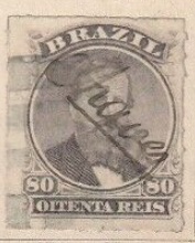
The first postmark has not yet been seen and will probably have been broken soon, as the stamps were cancelled by hand there from around 1876 (illustration from the Internet):
1876ff (EB)
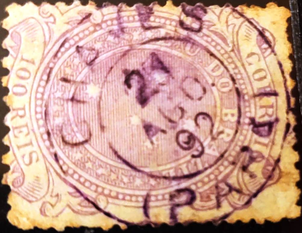
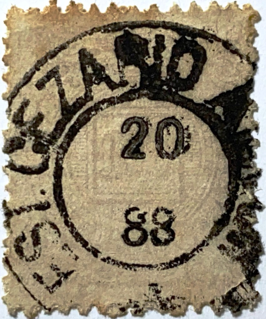
The oldest cancel is the double circle CPA-0075b (illustration from the Internet), which was found with a date of 1892:
CPA-0075b (EB) 1892
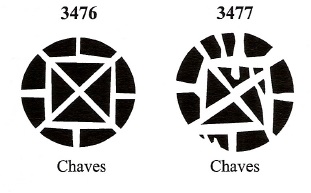
James Dingler and Klerman W. Lopes have recorded two mute cancels from Chaves in Mute Cancellations of the Brazil Empire / Carimbos Mudos do Brasil Império (Brazil Philatelic Association, Rio de Janeiro, 2000):
BPA 3476 (1876ff) – 3477Atlas do Imperio do Brasil, 1868
Andere Namen: Equador, Sto. Antonio de Aruãs
Der Überlieferung nach wurde auch dieser Ort nach einer portugiesischen Gemeinde benannt. Obwohl Santo Antonio de Chaves in der Provinz Pará 220 km nordwestlich der Provinzhauptstadt Belém liegt, dauert die Fahrt dorthin heute noch 2 Tage und 10 Stunden für 500 km. Chaves war bereits im Juli 1755 eine Vila, die im August 1834 in Equador umbenannt wurde. Dieser Name kam wohl nicht gut an, denn schon zehn Jahre später kehrte der alte Name zurück. Im Januar 1891 folgte die Erhebung zur Stadt. Im Juni 1932 wurde die Stadt in Sto. Antonio de Aruãs, der ebenfalls nicht gut ankam. Der Name Chaves kehrte im Oktober 1938 zurück.
Wie die Presse in Rio berichtete, gab es seit April 1865 ein Postamt am Ort:
Correio Mercantil/RJ, 28.04.1865
Der erste Poststempel ist noch nicht gesehen worden und wird wohl bald zerbrochen sein, denn ab etwa 1876 wurden die Marken dort von Hand entwertet (Abb. aus dem Internet):
1876ff (EB)
Der bisher älteste Stempel ist der Doppelkreis CPA-0075b (Abb. aus dem Internet), der mit einem Datum von 1892 gefunden wurde:
CPA-0075b (EB) 1892
Aus Chaves haben James Dingler und Klerman W. Lopes in Mute Cancellations of the Brazil Empire / Carimbos Mudos do Brasil Império (Brazil Philatelic Association, Rio de Janeiro, 2000) zwei stumme Stempel registriert:
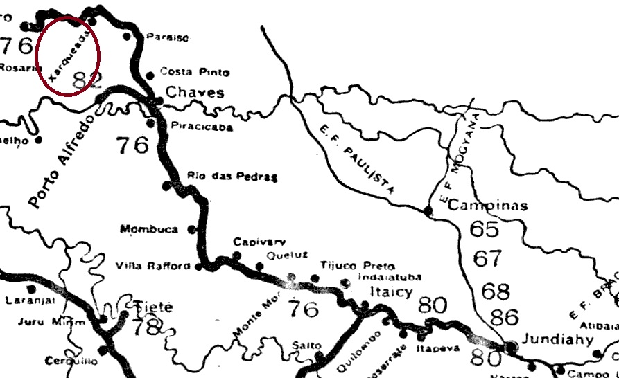
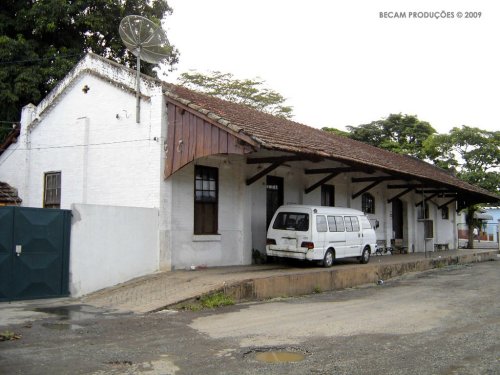
Charqueada station was opened in October 1887 by the E.F. Ytuana (Piracicaba branch) on the east bank of the Ribeirão Fregadoli in the Município Piracicaba, 180 km northwest of the provincial capital of São Paulo. The line went to the Cia. União Sorocabana e Ytuana in 1892, to the Sorocabana Railway in 1907 and belonged to E.F. Sorocabana from 1919 until it was closed in 1966 (estacoesferroviarias.com.br). Today, the tracks have disappeared and the station building serves as a warehouse for Charqueada, which has been an independent município since December 1953.
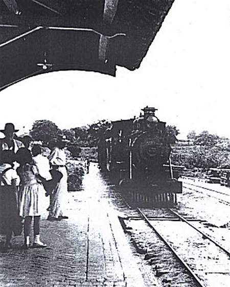
Charqueada station in the 1960s (Photo: Paulo Roberto Szabad, on estacoesferroviarias.com.br)In January 2009 (Photo: Adriano Martins, on estacoesferroviarias.com.br)
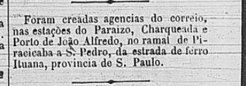
According to the Rio press, there had been a post office at the railway station since March 1888:
Cidade do Rio, 09/03/1888
No imperial postmark has yet been seen from this station.
Arthur D. Ribeiro: Estado de São Paulo, 1924
Der Bahnhof Charqueada wurde im Oktober 1887 von der E.F. Ytuana (Piracicaba-Abzweigung) eröffnet und lag am Ostufer des Ribeirão Fregadoli im Município Piracicaba, 180 km nordwestlich der Provinzhauptstadt São Paulo. Die Strecke ging 1892 an die Cia. União Sorocabana e Ytuana, 1907 an die Sorocabana Railway und gehörte von 1919 bis zur Stilllegung der Strecke 1966 der E.F. Sorocabana (estacoesferroviarias.com.br). Heute sind die Gleise verschwunden und das Bahnhofsgebäude dient als Lager der Gemeinde Charqueada, die seit Dezember 1953 ein eigenständiges Município ist.
Der Bahnhof in den 60er Jahren (Foto: Paulo Roberto Szabad, auf estacoesferroviarias.com.br)Im Januar 2009 (Foto: Adriano Martins, auf estacoesferroviarias.com.br)
Wie die Presse von Rio berichtet, gab es seit März 1888 ein Postamt am Bahnhof:
Cidade do Rio, 09.03.1888
Bisher wurde kein kaiserlicher Poststempel von diesem Bahnhof gesehen.
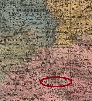
Villiers de l’Ile Adam: Carta (…) da Provincia de Minas Geraes, 1849
Other names: Paula Lima (1891)
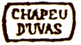
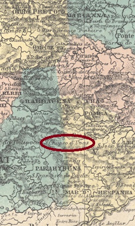
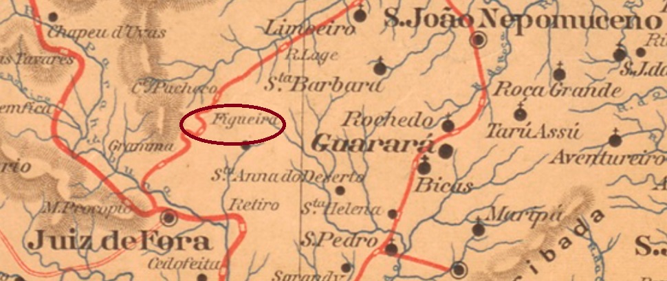
The Freguesia de N. Sra. da Assumpção do Chapeo d’Uvas was founded in 1810, belonged to the Vila de Barbacena, and lay 180 kilometres south of the later provincial capital of Ouro Preto. It was an important station on the Caminho Velho (Old Road) to Rio de Janeiro. In May 1850, the freguesia was incorporated into the newly founded Vila de Sto. Antonio do Paraibuna, which was given the name Juiz de Fora in December 1865. The name Chapeo d’Uvas is said to come from the indigenous name Chapetuva, “path through the swamp”. So, it is no wonder that the town was renamed Paula Lima in March. Paula Lima has been a rural suburb of the city of Juiz de Fora since May 1976. The name commemorates Count Francisco de Paula Lima (1812-1865), a wealthy landowner in the region.
Francisco de Paula Lima ca 1865
The local post office was opened at least three times. The first date could not be determined, but the postmark CMG-0730a (Fig. RHM catalogue) is said to have been used in 1835.
CMG-0730a (RHM) 1835
The second creation was commissioned at the end of October 1843, according to concurring information from R. Koester (Carimbologia XI), Nova Monteiro (Administrações e Agencias Postaes do Brasil Imperio, in Brasil Filatelico/RJ, 1934-5; reprint SPP 1994-1999) and a ministerial report from Rio:
Relatorio do Ministerio do Imperio, 1843
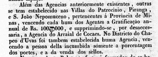
The agency was still in operation in 1859, but must have been closed shortly afterwards, as it was reopened in May 1864, as can be seen from the postal report (Relatorio dos Correios) for 1886.
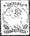
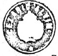
In the 70s, the next postmark was not yet available, as the stamps were cancelled by hand:
1876ff (fig. R. Koester, op. cit.)
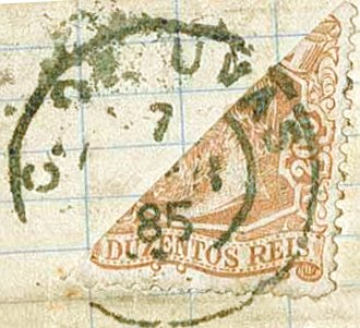
It was not until the 80s that CMG-0730b appeared (fig. Corinphila Auctions):
CMG-0730b (CO) 1883-1885
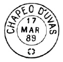
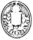
CMG-0730c also appeared in the late imperial period, as illustrated in Paulo Ayres’ Catálogo de Carimbos Brasil-Império, (S. Paulo, 1937, 1942) on p. 121:
CMG-0730c (P.A. p. 121) 1888-1889
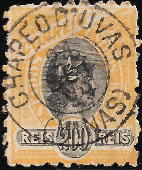
In the early Republic, the old place name was still used on postmarks:
CMG-0730d (EB) 1895-1899
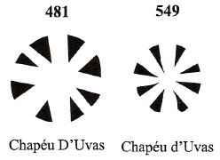
Two mute cancellations of Chapeo d’Uvas are also registered by James Dingler and Klerman W. Lopes in Mute Cancellations of the Brazil Empire / Carimbos Mudos do Brasil Império (Brazil Philatelic Association, Rio de Janeiro, 2000):
BPA 481 (1883) – 549Atlas do Imperio do Brasil, 1868
Andere Namen: Paula Lima (1891)
Die Freguesia de N. Sra. da Assumpção do Chapeo d’Uvas wurde 1810 gegründet und gehörte zur Vila de Barbacena, sie lag 180 km südlich der späteren Provinzhauptstadt Ouro Preto und war eine wichtige Station am Caminho Velho (Alter Weg) nach Rio de Janeiro. Im Mai 1850 wurde die Freguesia in die neu gegründete Vila de Sto. Antonio do Paraibuna, die im Dezember 1865 den Namen Juiz de Fora erhielt. Der Name Chapeo d’Uvas soll von der indigenen Bezeichnung Chapetuva, „Weg durch den Sumpf“, stammen. Kein Wunder also, dass der Ort im März in Paula Lima umbenannt wurde. Seit Mai 1976 ist Paula Lima ein ländlicher Vorort der Stadt Juiz de Fora. Der Name erinnert an den Komtur Francisco de Paula Lima (1812-1865), einen reichen Großgrundbesitzer der Region.
Francisco de Paula Lima ca 1865
Das örtliche Postamt wurde mindestens dreimal eröffnet. Das erste Datum konnte nicht ermittelt werden, aber der Poststempel CMG-0730a (Abb. RHM-Katalog) soll 1835 verwendet worden sein.
CMG-0730a (RHM) 1835
Die zweite Entstehung wurde Ende Oktober 1843 in Auftrag gegeben, nach übereinstimmenden Angaben von R. Koester (Carimbologia XI), Nova Monteiro (Administrações e Agencias Postaes do Brasil Imperio, in Brasil Filatelico/RJ, 1934-5; Reprint SPP 1994-1999) und einem Ministerialbericht aus Rio:
Relatorio do Ministerio do Imperio, 1843
Die Agentur war 1859 noch in Betrieb, muss aber kurz danach geschlossen worden sein, da sie im Mai 1864 wieder eröffnet wurde, wie aus dem Postbericht (Relatorio dos Correios) für 1886 hervorgeht.
In den 7oer Jahren ist der nächste Poststempel noch nicht vorhanden, da die Marken von Hand entwertet wurden:
1876ff (Abb. R. Koester, op.cit.)
Erst in den 80er Jahren erschien CMG-0730b (Abb. Corinphila Auktionen):
CMG-0730b (CO) 1883-1885
In der späten Kaiserzeit wurde auch CMG-0730c verwendet, wie in Paulo Ayres‘ Catálogo de Carimbos Brasil-Império (S. Paulo, 1937, 1942) auf S. 121 abgebildet:
CMG-0730c (P.A. S. 121) 1888-1889
In der frühen Republik wurde noch der alte Ortsname auf Poststempeln verwendet:
CMG-0730d (EB) 1895-1899
Von Chapeo d’Uvas sind auch zwei stumme Entwertungen von James Dingler und Klerman W. Lopes in Mute Cancellations of the Brazil Empire / Carimbos Mudos do Brasil Império (Brazil Philatelic Association, Rio de Janeiro, 2000) registriert:
Other names: Campo de Palmas, Passo Bormann, Passo dos Indios
In its relatively short history, the locality has experienced many turbulent times. At times it belonged to the province of São Paulo, at other times to the province of Paraná, was courted by Argentina, was placed in an autonomous region and yet has been part of the state of Santa Catarina for more than a century.
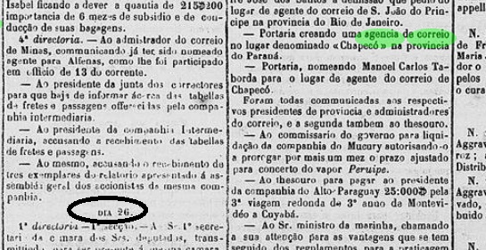
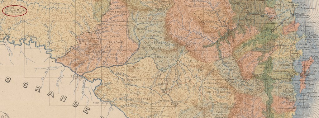
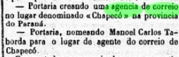
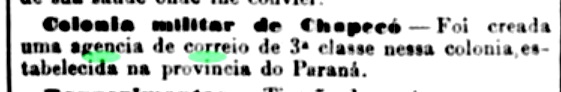
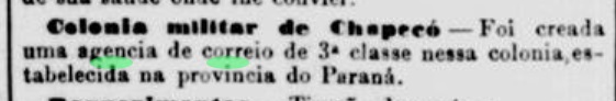
Settlement began around 1839 as Povoação de Campo de Palmas, 560 kilometres west of the future capital Florianópolis, but still part of the province of São Paulo. In August 1853, it became a colony called Vila de Palmas, which then belonged to the province of Paraná. The territory aroused covetousness in Argentina, which is why the Brazilian Empire established a military colony called Xapecó in November 1859. However, this did not begin operations until March 1882, a sign of political détente.
Three name changes followed. The first in August 1917 as Município de Passo Bormann, already in the state of Sta. The lieutenant José Bernardino Bormann (1844-1919), born in Porto Alegre from a German family, was the colony’s first director. In April 1931, it was renamed Município de Passo dos Indios. This name was obviously not well received, because in March 1938 it was renamed for the third time to Chapecó, as it is still known today. Between 1943 and 1946, Chapecó was in the Território do Iguaçu, an autonomous region created for geopolitical reasons.
The historical turmoil is reflected in the postal system. So far, three creation dates have been found for the local post office, but no postmarks. First in June 1862, as Nova Monteiro writes in Administrações e Agencias Postaes do Brasil Imperio (Brasil Filatelico/RJ, 1934-5; reprint SPP 1994-1999) and is confirmed by the press in Rio:
Diario do Rio de Janeiro, 18/07/1862
Then again in 1864, as R. Koester (Carimbologia XI) notes. And finally in June 1882, as also reported by Koester and the press in Rio:
Jornal do Commercio/RJ, 27/06/1882
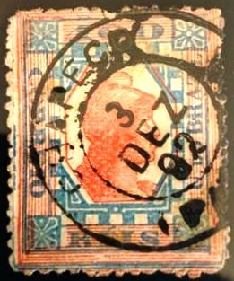
Until now, the only known ‘postmark’ was a handwritten cancellation on a D. Pedro issue from 1866, as mentioned by R. Koester – unfortunately without an illustration. In the meantime, the double circle CPR-0045b (illustration by Alexandre Andrade) has been found:
CPR-0045b (AA) 1892Mappa do Estado de Santa Catharina, 1907
Texto atualizado em 1º de março de 2026
Outros nomes: Campo de Palmas, Passo Bormann, Passo dos Indios
Em sua história relativamente curta, a localidade passou por muitos momentos de turbulência. Em alguns momentos, pertenceu à província de São Paulo, em outros, à província do Paraná, foi cortejada pela Argentina, estava localizada em uma região autônoma e além disso faz parte do estado de Santa Catarina há mais de um século.
A colonização começou por volta de 1839 como Povoação de Campo de Palmas, 560 quilômetros a oeste da futura capital Florianópolis, mas ainda parte da província de São Paulo. Em agosto de 1853, tornou-se uma colônia chamada Vila de Palmas, que então pertencia à província do Paraná. O território despertou a cobiça da Argentina, razão pela qual o Império brasileiro criou uma colônia militar chamada Xapecó em novembro de 1859. No entanto, ela só começou a funcionar em março de 1882, um sinal de distensão política.
Seguiram-se três mudanças de nome. A primeira, em agosto de 1917, como Município de Passo Bormann, já no estado de Sta. O tenente gaúcho de origem alemã José Bernardino Bormann (1844-1919) foi o primeiro diretor da colônia. Em abril de 1931, passou a se chamar Município de Passo dos Índios. Esse nome obviamente não foi bem recebido, pois em março de 1938 foi renomeado pela terceira vez para Chapecó, como é conhecido até hoje. Entre 1943 e 1946, Chapecó estava localizada no Território do Iguaçu, uma região autônoma criada por razões geopolíticas.
A turbulência histórica se reflete nos seus correios. Foram encontradas três datas de fundação para o correio local, mas sem carimbos postais. A primeira foi em junho de 1862, como escreve Nova Monteiro em Administrações e Agencias Postaes do Brasil Imperio (Brasil Filatelico/RJ, 1934-5; reimpressão SPP 1994-1999) e é confirmada pela imprensa do Rio:
Diario do Rio de Janeiro, 18/07/1862
Depois, novamente em 1864, como observa R. Koester (Carimbologia XI). E, finalmente, em junho de 1882, como também relatado por Koester e pela imprensa do Rio:
Jornal do Commercio/RJ, 27/06/1882
Até agora, o único “carimbo postal” conhecido era uma oobliteração manuscrita em um selo de D. Pedro de 1866, conforme mencionado por R. Koester — infelizmente sem ilustração. Entretanto, agora foi encontrado o círculo duplo CPR-0045b (ilustração de Alexandre Andrade):
CPR-0045b (AA) 1892Google Maps
Textaktualisierung am 1. März 2026
Andere Namen: Campo de Palmas, Passo Bormann, Passo dos Indios
In seiner relativ kurzen Geschichte hat der Ort viele bewegte Zeiten erlebt. Sie gehörte mal zur Provinz São Paulo, mal zur Provinz Paraná, wurde von Argentinien umworben, lag in einem autonomen Gebiet und ist doch seit mehr als einem Jahrhundert Teil des Bundesstaates Santa Catarina.
Die Besiedlung begann um 1839 als Povoação de Campo de Palmas, 560 km westlich der späteren Hauptstadt Florianópolis, aber noch zur Provinz São Paulo gehörig. Im August 1853 wurde daraus eine Kolonie mit dem Namen Vila de Palmas, die dann zur Provinz Paraná gehörte. Das Gebiet weckte Begehrlichkeiten in Argentinien, weshalb das bras. Kaiserreich im November 1859 eine Militärkolonie namens Xapecó. Diese nahm jedoch erst im März 1882, als Zeichen der politischen Entspannung, ihren Betrieb auf.
Es folgten drei Namensänderungen. Die erste im August 1917 als Município de Passo Bormann, bereits im Staat Sta. Catarina. Der in Porto Alegre geborene, deutschstämmige Leutnant José Bernardino Bormann (1844-1919) war der erste Direktor der Kolonie. Im April 1931 wurde sie dann in Município de Passo dos Indios umbenannt. Dieser Name kam offensichtlich nicht gut an, denn bereits im März 1938 erfolgte die dritte Umbenennung in die Stadt Chapecó, wie sie heute noch bekannt ist. Zwischen 1943 und 1946 lag Chapecó im Território do Iguaçu, einem aus geopolitischen Gründen geschaffenen autonomen Gebiet.
Die historischen Wirren spiegeln sich im Postwesen wider. Für das örtliche Postamt wurden bisher drei Gründungsdaten, aber keine Poststempel gefunden. Zuerst im Juni 1862, wie Nova Monteiro in Administrações e Agencias Postaes do Brasil Imperio (Brasil Filatelico/RJ, 1934-5; Nachdruck SPP 1994-1999) schreibt und von der Presse in Rio bestätigt wird:
Diario do Rio de Janeiro, 18.07.1862
Dann wieder 1864, wie R. Koester (Carimbologia XI) bemerkt. Und zuletzt im Juni 1882, wie ebenfalls von Koester und der Presse in Rio berichtet:
Jornal do Commercio/RJ, 27.06.1882
Als bisher einziger „Poststempel“ galt eine handschriftliche Entwertung auf einer D. Pedro-Marke von 1866, wie bei R. Koester – leider ohne Abbildung – erwähnt. Inzwischen wurde der Doppelkreis CPR-0045b (Abb. Alexandre Andrade) gefunden:
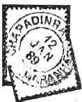
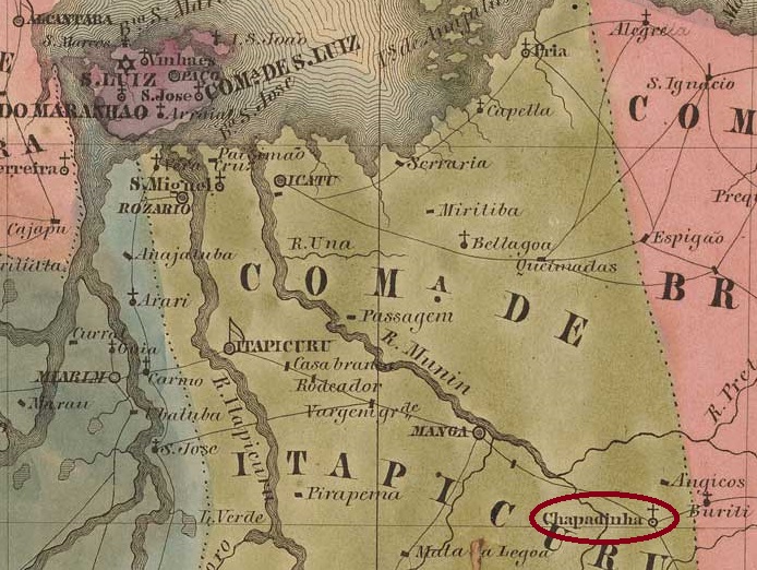
The settlement was originally called Chapada das Mulatas (Hillside of the Mulatines) and was located 240 kilometres south-east of the later provincial capital of S. Luís do Maranhão. In September 1801, it became the Freguesia de N. Sra. das Dores da Chapadinha, which belonged to the Vila de Vargem Grande. Chapadinha has been an independent município since October 1890.
The local post office was established in December 1882, as reported by R. Koester in Carimbologia XI. The only imperial postmark to date is CMA-0090a (illus. R. Koester):
CMA-0090a (RK) 1889Villiers de l’Ile Adam: Carta (…) da Provincia do Maranhão, 1850
Andere Namen: Chapada das Mulatas
Die Siedlung hieß ursprünglich Chapada das Mulatas (Berghang der Mulattinen) und lag 240 km südöstlich der späteren Provinzhauptstadt S. Luís do Maranhão. Im September 1801 wurde sie die Freguesia de N. Sra. das Dores da Chapadinha, die zur Vila de Vargem Grande gehörte. Seit Oktober 1890 ist Chapadinha ein selbständiger Município.
Das örtliche Postamt wurde im Dezember 1882 eingerichtet, wie R. Koester in Carimbologia XI berichtet. Der bisher einzige kaiserliche Poststempel ist CMA-0090a (Abb. R. Koester):
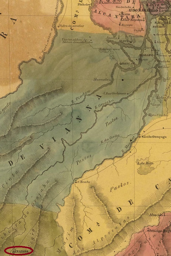
The history of this settlement begins around 1811 with the construction of a harbour at Fazenda Chapada on the west bank of the Grajaú, 560 km south of the later provincial capital S. Luís do Maranhão. As early as 1817, the Arraial was called S. Paulo do Norte and belonged to the Vila de Pastos Bons. In April 1835, it was elevated to Vila do Senhor do Bomfim da Chapada, which became the town of Grajaú in April 1881.
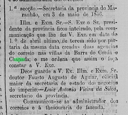
There are three creation dates for the local post office. They are so close together that they can be safely summarised. The first was at the end of March 1856, as Aureo G. Santos writes in Agências de Correio Criadas e Suprimidas 1851, 1855, 1856 e 1857 (Brasil Filatélico 181, Rio de Janeiro, 1977):
Aureo G. Santos (op. cit.)
The regional press mentions on the other hand 1 April 1856:
Publicador Maranhense, 06/05/1856
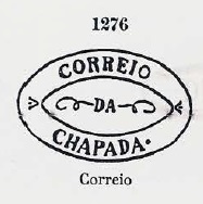
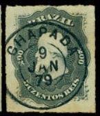
And R. Koester indicates 5 April 1856 in Carimbologia XI. The oldest postmark to date is CMA-0085a with the typical shape for the province of Maranhão, which was already presented by P. Ayres in Catálogo de Carimbos Brasil-Império (S. Paulo, 1937, 1942) with no. 1276:
CMA-0085a (P.A. 1276) 1856ff
It was followed by the double circle CMA-0085b (illustration from the Internet):
CMA-0085b (EB) 1879Villiers de l’Ile Adam: Carta (…) da provincia do Maranhão, 1850
Die Geschichte der Siedlung beginnt um 1811 mit dem Bau eines Hafens der Fazenda Chapada am Westufer des Grajaú, 560 km südlich der späteren Provinzhauptstadt S. Luís do Maranhão. Bereits 1817 hieß der Arraial S. Paulo do Norte und gehörte zur Vila de Pastos Bons. Im April 1835 erfolgte die Erhebung zur Vila do Senhor do Bomfim da Chapada, die seit April 1881 die Stadt Grajaú ist.
Es gibt drei Gründungsdaten für das örtliche Postamt. Sie liegen so nahe beieinander, dass man sie getrost zusammenfassen kann. Zum ersten Mal Ende März 1856, wie Aureo G. Santos in Agências de Correio Criadas e Suprimidas 1851, 1855, 1856 e 1857 (Brasil Filatélico 181, Rio de Janeiro, 1977) schreibt:
Aureo G. Santos (op. cit.)
Die regionale Presse erwähnt dafür den 1. April 1856:
Publicador Maranhense, 06.05.1856
Und R. Koester gibt in Carimbologia XI den 5. April 1856 an. Der bisher älteste Poststempel ist CMA-0085a mit der für die Provinz Maranhão typischen Form, der bereits von P. Ayres in Catálogo de Carimbos Brasil-Império (S. Paulo, 1937, 1942) mit Nr. 1276 vorgestellt wurde:
CMA-0085a (P.A. 1276) 1856ff
Ihm folgte der Doppelkreis CMA-0085b (Abbildung aus dem Internet):
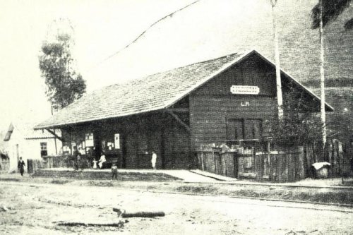
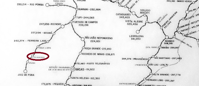
Chácara (estate) was a settlement of the Vila de Juiz de Fora on the south bank of the Cágado, 240 kilometres south of the provincial capital Ouro Preto. In October 1884, it was elevated to the Freguesia de S. Sebastião da Chácara, which has been an independent município since March 1963.
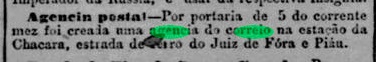
As Paula Sobrinho writes in História Postal de Minas Gerais (Belo Horizonte, 1997), there has been a post office there since October 1882, which is confirmed by the press in Rio:
O Globo/RJ, 28/10/1882
The oldest postmark to date is CMG-0725a, illustrated in R. Koester’s Carimbologia XI:
CMG-0725a (RK) 1882ff
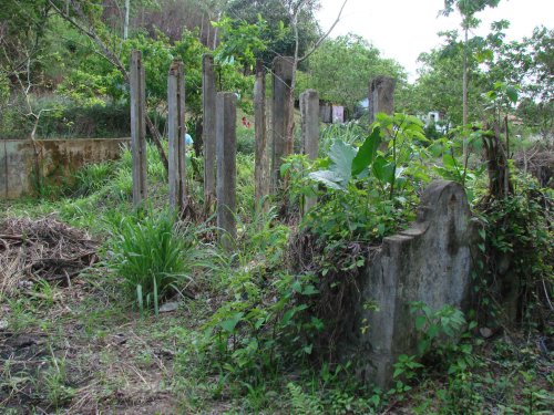
In 1884, the railway station of the E.F. de Juiz de Fora ao Piau, later called Comemdador Filgueiras, was inaugurated. The railway line belonged to E.F. Leopoldina from 1888 until it was closed in 1972. Today, the tracks have disappeared, and the station building has been demolished.
In 1915 (Photo: Album de Juiz de Fora/Albino Esteves, on estacoesferroviarias.com.br)In 1987: Demolition of the station (ph.: Hugo Caramuru, on estacoesferroviarias.com.br)
As the Rio press reported, a railway station post office was opened in March 1885:
Jornal do Commercio/RJ, 06/03/1885
No postmark has yet been found for the Chácara railway station. It is possible that the old local postmarks continued to be used there.
Estrada de Ferro Leopoldina
Chácara (Landgut) war eine Siedlung der Vila de Juiz de Fora am Südufer des Cágado, 240 km südlich der Provinzhauptstadt Ouro Preto. Im Oktober 1884 wurde sie zur Freguesia de S. Sebastião da Chácara erhoben, die seit März 1963 ein eigenständiges Município ist.
Wie Paula Sobrinho in História Postal de Minas Gerais (Belo Horizonte, 1997) schreibt, gab es dort seit Oktober 1882 ein Postamt, was von der Presse in Rio bestätigt wird:
O Globo/RJ, 28.10.1882
Der bisher älteste Poststempel ist CMG-0725a, abgebildet in R. Koesters Carimbologia XI:
CMG-0725a (RK) 1882ff
1884 wurde der Bahnhof der E.F. de Juiz de Fora ao Piau, später Comemdador Filgueiras, eingeweiht. Die Bahnlinie gehörte von 1888 bis zu ihrer Stilllegung 1972 der E.F. Leopoldina. Heute sind die Gleise verschwunden, das Bahnhofsgebäude wurde abgerissen.
1915 (Foto aus Album de Juiz de Fora/Albino Esteves, auf estacoesferroviarias.com.br)1987: Abriss des Bahnhofs (Foto Hugo Caramuru, auf estacoesferroviarias.com.br)
Wie die Presse von Rio berichtete, wurde im März 1885 ein Bahnhofspostamt eröffnet:
Jornal do Commercio/RJ, 06.03.1885
Vom Bahnhof Chácara wurde bisher kein Poststempel gefunden. Möglicherweise wurden dort die alten Ortsstempel weiterverwendet.
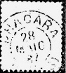
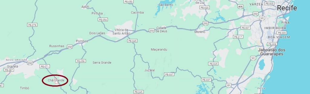
From around 1878, Chã Grande was a settlement of the Vila de Gravatá near the east bank of the Ipojuca, 80 kilometres west of the provincial capital Recife. The village became a district around 1910 and has been an independent município since December 1963.
According to the Rio press, there has been a post office there since August 1884.
Diario do Brazil/RJ, 15/08/1884
No imperial postmarks are yet known from Chã Grande.
Google Maps
Chã Grande war ab ca. 1878 eine Siedlung der Vila de Gravatá nah am Ostufer des Ipojuca, 80 km westlich der Provinzhauptstadt Recife. Der Ort wurde um 1910 ein Distrikt und ist seit Dezember 1963 ein eigenständiger Município.
Laut Presse aus Rio gab es dort seit August 1884 ein Postamt.
Diario do Brazil/RJ, 15.08.1884
Aus Chã Grande sind bisher keine kaiserlichen Poststempel bekannt.
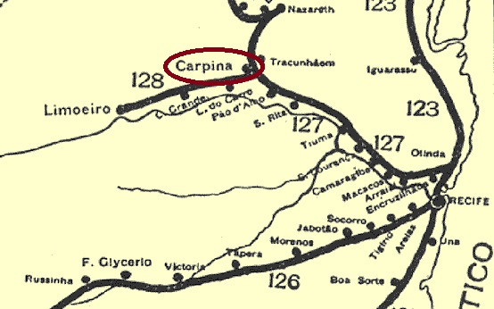
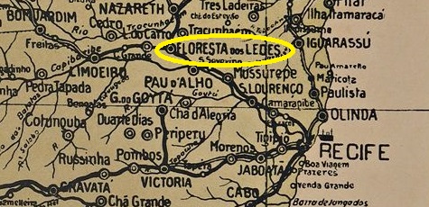
Other names: Cham do Carpina, Floresta dos Leões, Carpina (1938)
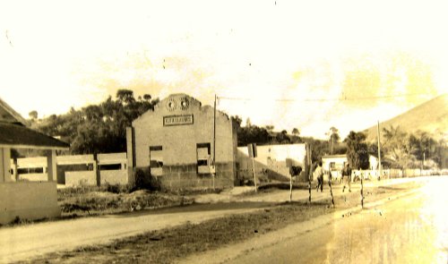
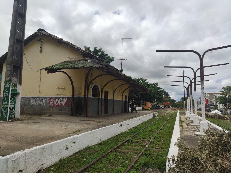
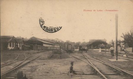
Chã do Carpina station was opened in October 1881 by the railway company E.F. do Limoeiro (which in turn belonged to Great Western do Brasil) and was located in the municipality of Vila de Pau d’Alho, 55 km north-west of the provincial capital Recife. The line changed hands to Rede Ferroviária do Nordeste in 1950 and belonged to Rede Ferroviária Federal S.A. (estacoesferroviarias.com.br) from 1975 until the line was closed in 1996. Today, the tracks are still in place and the station building was last used as a lan-house.
In 1915 (photo on estacoesferroviarias.com.br)In 2021 (photo Rodrigo Henrique, on estacoesferroviarias.com.br)
The area around the railway station became the district of Floresta dos Leões (Lion Forest) in December 1901, a name that was later also given to the station. In July 1909, Floresta dos Leões became an independent município, which has been called Carpina since December 1938. Carpina was also the original landowner of the village, who lived on a hill (chã).
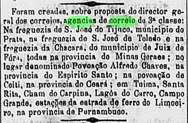
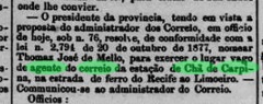
As the press in Rio reported, the decision to set up a railway post office was made as early as October 1882:
O Globo/RJ, 28/10/1882
However, the directory of imperial post offices (Tabella das Agencias do Correio do Imperio, Rio de Janeiro, 1885) lists the agency without a founding date, and a local postal employee is only introduced in January 1885:
Diario de Pernambuco, 01/02/1885, minutes of 23/01
In Carimbologia XI, Reinhold Koester describes – unfortunately without an illustration – the first postmark CPE-0190a as a double circle in blue, dated 1889.
Arthur D. Ribeiro: Estado de Pernambuco, 1924
Andere Namen: Cham do Carpina, Floresta dos Leões, Carpina (1938)
Der Bahnhof Chã do Carpina wurde im Oktober 1881 von der Eisenbahngesellschaft E.F. do Limoeiro (die wiederum zur Great Western do Brasil gehörte) eröffnet und lag in der Gemeinde Vila de Pau d’Alho, 55 km nordwestlich der Provinzhauptstadt Recife. Die Strecke wechselte 1950 den Besitzer zur Rede Ferroviária do Nordeste und gehörte von 1975 bis zur Stilllegung der Strecke 1996 der Rede Ferroviária Federal S.A. (estacoesferroviarias.com.br). Heute sind die Gleise noch vorhanden, im Bahnhofsgebäude war zuletzt ein Lan-House in Betrieb.
1915 (Foto auf estacoesferroviarias.com.br)2021 (Foto Rodrigo Henrique, auf estacoesferroviarias.com.br)
Das Gebiet um den Bahnhof wurde im Dezember 1901 zum Bezirk Floresta dos Leões (Löwenwald), ein Name, den später auch der Bahnhof erhielt. Im Juli 1909 wurde Floresta dos Leões ein eigenständiger Município, das seit Dezember 1938 Carpina heißt. Carpina war auch der ursprüngliche Landbesitzer des Ortes, der auf einem Hügel (chã) lebte.
Wie die Presse in Rio berichtete, wurde bereits im Oktober 1882 die Einrichtung eines Bahnhofspostamtes beschlossen:
O Globo/RJ, 28.10.1882
Im Verzeichnis der kaiserlichen Postämter (Tabella das Agencias do Correio do Imperio, Rio de Janeiro, 1885) wird die Agentur jedoch ohne Gründungsdatum aufgeführt, und ein Postangestellter vor Ort wird erst im Januar 1885 vorgestellt:
Diario de Pernambuco, 01.02.1885, Protokoll vom 23.01.
Reinhold Koester beschreibt – leider ohne Abbildung – in Carimbologia XI den ersten Poststempel CPE-0190a als Doppelkreis in Blau, datiert 1889.
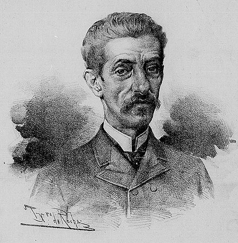
Cezario Alvim station was opened in August 1886 by the railway company E.F. Cantagallo (Coastal Line) in the Município de Capivary, 100 km east of the capital Rio de Janeiro. The line went to E.F. Leopoldina in 1887 and belonged to Rede Ferroviária Federal S.A. (estacoesferroviarias.com.br) from 1975 until it was closed in 1996. Since December 1943, the station has been in the Município de Silva Jardim. The tracks are still there today, but the station building has long since been demolished.
In 2007 (Photo Marcelo Cardozo, on estacoesferroviarias.com.br)
The station commemorated José Cesário de Faria Alvim (1839-1909), a lawyer, landowner and politician who was president of both the imperial province of Rio de Janeiro and the republican state of Minas Gerais. Cesário Alvim is the great-grandfather of the composer Chico Buarque.
Cesario Alvim, 1890 (drawn by Teixeira da Rocha)
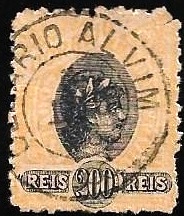
As Paulo Novaes writes on agenciaspostais.com.br, there had been a post office at the station since December 1886, and a postmark has meanwhile emerged that is probably the oldest there, the double circle CRJ-0340a (fig. Felipe Piccinini):
CRJ-0340a (FP) 1888
R. Koester had previously shown two imperial seal cancels in Carimbologia XI:
CRJ-0340b (RK)CRJ-0340c (RK)
CRJ-0340d was added in the early Republic (fig. agenciaspostais.com.br):
CRJ-0340d (PN)Estrada de Ferro Leopoldina
Textaktualisierung am 9. Januar 2025
Der Bahnhof Cezario Alvim wurde im August 1886 von der Eisenbahngesellschaft E.F. Cantagallo (Küstenlinie) eröffnet und lag im Município de Capivary, 100 km östlich der Hauptstadt Rio de Janeiro. Die Strecke ging 1887 an die E.F. Leopoldina und gehörte von 1975 bis zu ihrer Stilllegung 1996 der Rede Ferroviária Federal S.A. (estacoesferroviarias.com.br). Seit Dezember 1943 befindet sich der Bahnhof im Município de Silva Jardim. Heute sind die Gleise noch vorhanden, das Bahnhofsgebäude ist längst abgerissen.
2007 (Foto Marcelo Cardozo, auf estacoesferroviarias.com.br)
Der Bahnhof erinnerte an José Cesário de Faria Alvim (1839-1909), Jurist, Landbesitzer und Politiker, der Präsident sowohl der kaiserlichen Provinz Rio de Janeiro als auch des republikanischen Staats Minas Gerais war. Cesário Alvim ist der Urgroßvater des Komponisten Chico Buarque.
Cesario Alvim, 1890 (gez. von Teixeira da Rocha)
Wie Paulo Novaes auf agenciaspostais.com.br schreibt, gab es im Bahnhof seit Dezember 1886 ein Postamt, von dem inzwischen ein Stempel aufgetaucht ist, der der älteste dort sein dürfte: der Doppelkreis CRJ-0340a (Abb. Felipe Piccinini):
CRJ-0340a (FP) 1888CRJ-0340b (RK)CRJ-0340c (RK)
In der frühen Republik kam CRJ-0340d hinzu (Abb. agenciaspostais.com.br):