Other names: Santo Antonio do Paquequer
See also Theresopolis (TRJ- 2275), Várzea de Theresopolis (VRJ-2275)
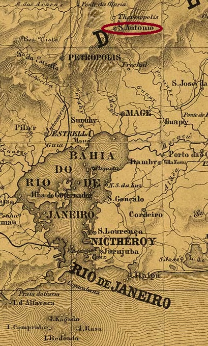
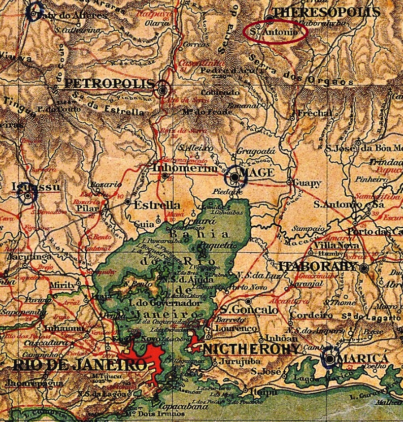
This village became the district of Santo Antonio do Paquequer near Magé in October 1855 and was located on the Paquequer River, barely 100 km north of the capital Rio de Janeiro. Around this time, the place name Theresopolis came into use – a homage to Empress Theresa Christina (1822-1889), the wife of D. Pedro II – although the official change of place name did not take place until May 1892 and thus already in the Republic. The place had already been a vila since July 1891 and became a town in January 1893. Today Alto is a quarter of the town of Teresopolis. In older maps (see above and below), one finds the name Santo Antonio for Alto de Theresopolis in the south and Theresopolis for the Varzea in the north.
In the upper part of the town, a post office was opened in October 1874 under the name Alto de Theresopolis. The press announcement at the time seemed to foreshadow that there would be confusion between the two local agencies:
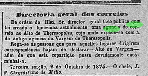
The confusion was probably the reason for changing the name of the older post office to Várzea de Theresopolis (Lower Theresopolis) towards the end of the Empire. Curiously, there seems to be no town cancel under the official name Santo Antonio do Paquequer.
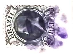
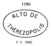
The oldest postmark of Alto de Theresopolis is ARJ-2450a, in use between 1874 and 1889 and already made known by Paulo Ayres in Catálogo de Carimbos Brasil-Império (S. Paulo, 1937, 1942) under No. 1196:

It was followed by ARJ-2450b (agenciaspostais.com.br): a double circle with the inscription ALTO DE THERESOPOLIS above and an ornament in the shape of a hollow cross below. The dates in the centre have so far been found for the period 1889-1899. There is also a mute cancellation from 1889:

Andere Namen: Santo Antonio do Paquequer
Siehe auch Theresopolis (TRJ- 2275), Várzea de Theresopolis (VRJ-2275)
Diese Ortschaft wurde ab Oktober 1855 der Distrikt von Santo Antonio do Paquequer bei Magé und lag am Fluss Paquequer, knapp 100 km nördlich der Hauptstadt Rio de Janeiro entfernt. Um diese Zeit kam auch der Ortsname Theresopolis zu Gebrauch – eine Hommage an die Kaiserin Theresa Christina (1822-1889), die Frau von D. Pedro II – obwohl der offizielle Ortsnamenswechsel erst im Mai 1892 und damit schon in der Republik stattfand. Da war der Ort bereits seit Juli 1891 eine Vila, und wurde im Januar 1893 eine Stadt. Heute ist Alto ein Stadtteil von Teresopolis. In den älteren Karten (s.o.) findet man den Namen Santo Antonio für Alto de Theresopolis im Süden und Theresopolis für die Varzea im Norden.
Im oberen Ortsteil wurde im Oktober 1874 ein Postamt unter dem Namen Alto de Theresopolis eröffnet. Die damalige Presseankündigung schien zu ahnen, dass es Verwechslungen zwischen beiden Agenturen vor Ort geben würde:

Diario do Rio de Janeiro, 03.10.1874
Die Verwechslungen waren gegen Ende des Kaiserreichs wohl der Anlass zur Namensänderung des älteren Postamts zu Várzea de Theresopolis (Unterer Theresopolis). Merkwürdigerweise scheint es keinen Ortsstempel mit dem offiziellen Namen Santo Antonio do Paquequer zu geben.
Der älteste Poststempel hier ist ARJ-2450a, der zwischen 1874 und 1889 Verwendung fand und bereits durch Paulo Ayres in Catálogo de Carimbos Brasil-Império (S. Paulo, 1937, 1942) unter der Nr. 1196 bekannt ist:
Ihm folgte ARJ-2450b (agenciaspostais.com.br): ein Doppelkreis mit der Inschrift ALTO DE THERESOPOLIS oben und einem Ornament in Form eines hohlen Kreuzes unten. Die Daten in der Mitte wurden bisher für den Zeitraum 1889-1899 gefunden. Aus 1889 kommt auch eine stumme Entwertung: