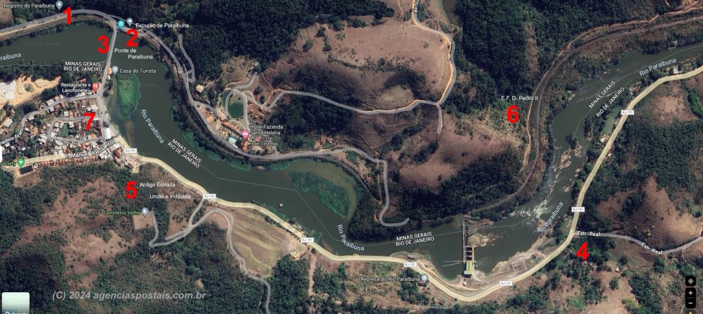
Other names: Ponte do Parahybuna
See also Registro do Parahybuna (RRJ-3930) – Mont-Serrat (MMG-1646)
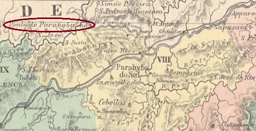
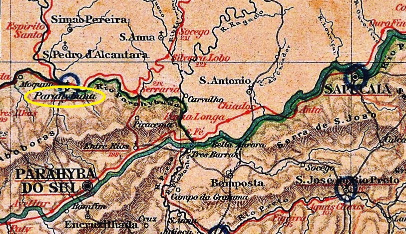
The Parahybuna (now spelled Paraibuna) is a river that rises in the mountains of the Zona da Mata in Minas Gerais. From there, it flows south to the border with Rio de Janeiro, where it joins the Rio Preto. It then continues along the border until it flows into the Parahyba (now Paraíba) do Sul near the city of Três Rios.
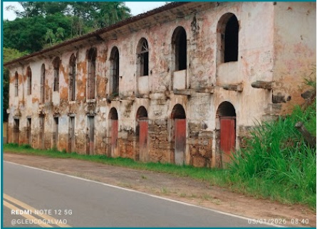
The Registro do Parahybuna was built at the beginning of the 18th century as a tax or toll station on the north bank, i.e. in Minas Gerais, and enabled a new trade route (Caminho Novo) between Minas Gerais and Rio de Janeiro. It was located 250 kilometres south of the provincial capital Ouro Preto, but was administered from Rio de Janeiro. The ruins of this building still exist today – together with a bridge built in the 19th century – and are now tourist attractions.

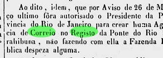
According to the imperial official press, there had been a post office there since March 1840:
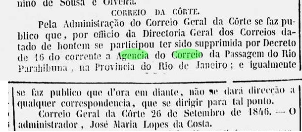
This was closed in September 1846:

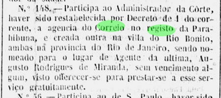
It reopened in 1847:

In the following period, the agency was closed intermittently and was occasionally renamed Ponte do Paraibuna. From the first period, only handwritten cancellations are known to date, the exact origin of which cannot be determined as they could also have come from the Parahibuna post office in the province of São Paulo (PSP-0860).


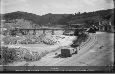
The situation became more complicated in September 1874 with the construction of the Parahybuna railway station of the E. F. D. Pedro II right next to the Registro. From 1875 onwards, the station also had its own post office, which presumably operated in parallel with the post office agency at the Registro for several years. The railway line was transferred to the E.F. Central do Brasil in 1889 and belonged to Rede Ferroviária Federal S.A. from 1975 until it was decommissioned in 1996 (estacoesferroviarias.com.br). Today, the tracks are still in place and the station building is to be used for residential purposes.

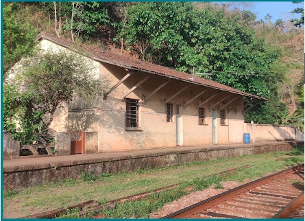
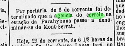
Originally, Parahybuna station was located in the municipality of Juiz de Fora. From September 1923, it belonged to the municipality of Matias Barbosa. Since March 1963, the station and the Registro area have been part of the municipality of Simão Pereira. In November 1886, the Parahybuna station post office was renamed Monte Serrat.

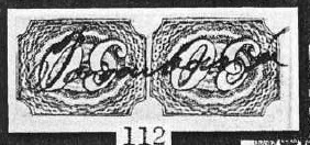
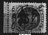
The only surviving Registro postmark, RRJ-3930a (fig. Corinphila Auctions), presents a mystery:

The first letter was originally a P (for Ponte?) and was changed by hand to an R (for Registro).
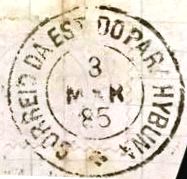
The only station postmark known to date is PMG-3931a (illustration from the internet):

Outros nomes: Ponte do Parahybuna
Veja também Registro do Parahybuna (RRJ-3930) – Mont-Serrat (MMG-1646)
O Paraibuna é um rio que nasce nas montanhas da Zona da Mata Mineira. De lá, segue para o sul até a divisa com o Rio de Janeiro, onde se junta ao Rio Preto. Continua então ao longo da divisa até desaguar no Paraíba do Sul, próximo à cidade de Três Rios.
O Registro do Paraibuna foi construído no início do século XVIII como uma estação tributária ou pedágio na margem norte do rio, ou seja, em Minas Gerais, e possibilitou uma nova rota comercial (Caminho Novo) entre Minas e o Rio de Janeiro. Ele ficava localizado 250 quilômetros ao sul da capital provincial Ouro Preto, mas era administrado a partir do Rio de Janeiro. As ruínas desse edifício ainda existem hoje – juntamente com uma ponte construída no século XIX – e são agora atrações turísticas.

De acordo com a imprensa oficial imperial, havia uma agência dos correios no local desde março de 1840:

Esta foi fechada em setembro de 1846:

Mas reabriu em 1847:

No período seguinte, a agência foi fechada intermitentemente e ocasionalmente renomeada como Ponte do Paraibuna. Do primeiro período, só se conhecem até hoje cancelamentos manuscritos, cuja origem exata não pode ser definitivamente confirmada, pois também poderiam ter vindo da agência dos correios de Paraibuna, na província de São Paulo (PSP-0860).

A situação se complicou em setembro de 1874 com a construção da estação ferroviária de Paraibuna da E. F. D. Pedro II, bem ao lado do Registro. A partir de 1875, a estação também passou a ter sua própria agência dos correios, que provavelmente funcionou em paralelo com a agência dos correios do Registro por vários anos. A linha ferroviária foi transferida para a E.F. Central do Brasil em 1889 e pertenceu à Rede Ferroviária Federal S.A. de 1975 até ser desativada em 1996 (estacoesferroviarias.com.br). Hoje, os trilhos ainda estão lá e o prédio da estação seria usado para fins residenciais.

Originalmente, a estação de Parahybuna estava localizada no município de Juiz de Fora. A partir de setembro de 1923, passou a pertencer ao município de Matias Barbosa. Desde março de 1963, a estação e a área do Registro fazem parte do município de Simão Pereira. Em novembro de 1886, a agência dos correios da estação de Parahybuna foi renomeada para Monte Serrat.
O único carimbo postal imperial do Registro até agora, RRJ-3930a (fig. Corinphila Auctions), apresenta um mistério:
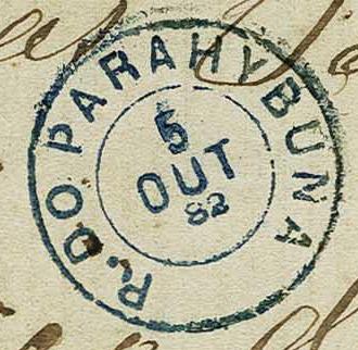
A primeira letra era originalmente um P (de Ponte?) e foi alterada à mão para um R (de Registro).
O único carimbo postal da estação conhecido até o momento é o PMG-3931a (ilustração da internet):
Andere Namen: Ponte do Parahybuna
Siehe auch Registro do Parahybuna (RRJ-3930) – Mont-Serrat (MMG-1646)
Der Parahybuna (heute Paraibuna geschrieben) ist ein Fluss, der im Gebirge der Zona da Mata in Minas Gerais entspringt. Von dort fließt er in Richtung Süden bis zur Grenze zu Rio de Janeiro, wo er den Rio Preto aufnimmt. Anschließend fließt er entlang der Grenze weiter, bis er in den Parahyba (heute Paraíba) do Sul nahe der Stadt Três Rios mündet.
Der Registro do Parahybuna wurde zu Beginn des 18. Jahrhunderts als Steuer- oder Mautstelle am Nordufer, also in Minas Gerais, gebaut und ermöglichte einen neuen Handelsweg (Caminho Novo) zwischen Minas Gerais und Rio de Janeiro. Er lag 250 Kilometer südlich der Provinzhauptstadt Ouro Preto, wurde jedoch von Rio de Janeiro aus verwaltet. Von diesem Bau existieren heute noch die Ruinen – zusammen mit einer im 19. Jahrhundert entstandenen Brücke – die heute touristische Attraktionen sind.
Wie aus der kaiserlichen Amtspresse hervorgeht, gab es dort seit März 1840 ein Postamt:

Dieses wurde im September 1846 geschlossen:
Eine Wiedereröffnung fand 1847 statt:
In der Folgezeit war die Agentur zwischendurch geschlossen und wurde gelegentlich in Ponte do Paraibuna umbenannt. Aus der ersten Periode sind bisher lediglich handschriftliche Entwertungen bekannt, deren genaue Zuordnung nicht möglich ist, da sie auch aus dem Postamt Parahibuna in der Provinz São Paulo (PSP-0860) stammen könnten.


Die Lage wurde im September 1874 durch den Bau des Bahnhofs Parahybuna der E. F. D. Pedro II gleich neben dem Registro komplizierter. Ab 1875 verfügte der Bahnhof auch über ein eigenes Postamt, das vermutlich einige Jahre parallel zur Postagentur am Registro in Betrieb war. Die Bahnlinie ging 1889 an die E.F. Central do Brasil über und gehörte von 1975 bis zur Stilllegung im Jahr 1996 zur Rede Ferroviária Federal S.A. (estacoesferroviarias.com.br). Heute sind die Gleise noch vorhanden und das Bahnhofsgebäude soll zu Wohnzwecken genutzt werden.


Ursprünglich lag der Bahnhof Parahybuna noch im Gebiet des Município de Juiz de Fora. Ab September 1923 gehörte er zum Município de Matias Barbosa. Seit März 1963 liegen der Bahnhof und das Gebiet Registro im Município de Simão Pereira. Im November 1886 wurde das Bahnhofspostamt Parahybuna in Monte Serrat umbenannt.

Der einzige überlieferte Registro-Stempel RRJ-3930a (Abb. Corinphila Auktionen) bringt gleich einen Rätsel mit:

Der erste Buchstabe war ursprünglich ein P (für Ponte?), und wurde per Hand zu einem R (für Registro) geändert.
Der bisher einzige Bahnhofs-Poststempel ist PMG-3931a (Abb. aus dem Internet):

