Categories
Carimbologia A-B

Bom Jardim, Minas Gerais (BMG-0330)

Atlas do Imperio do Brasil, 1868

Another name: Bom Jardim de Minas (1943)

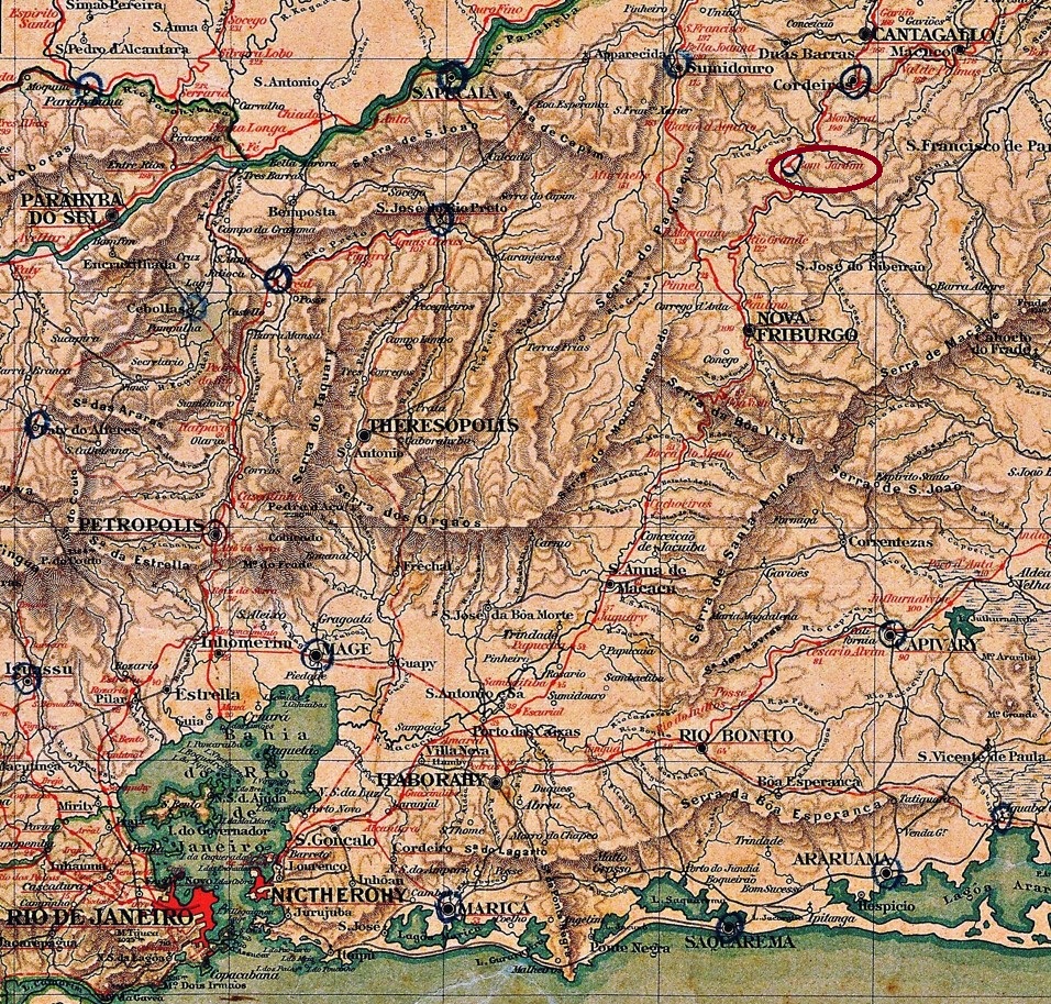
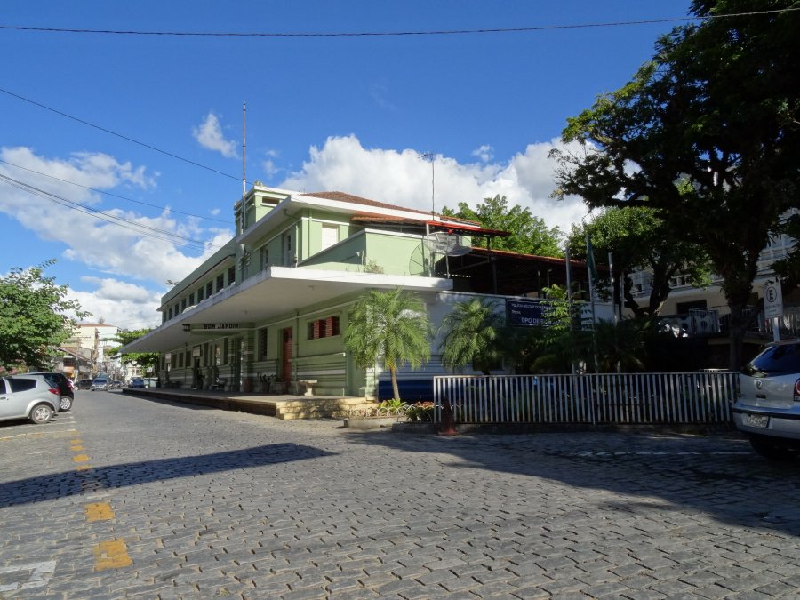
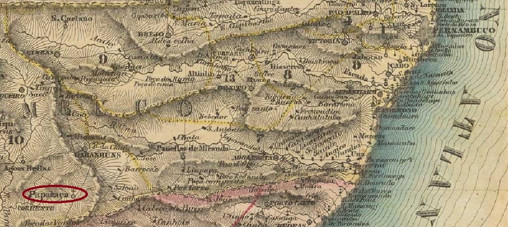
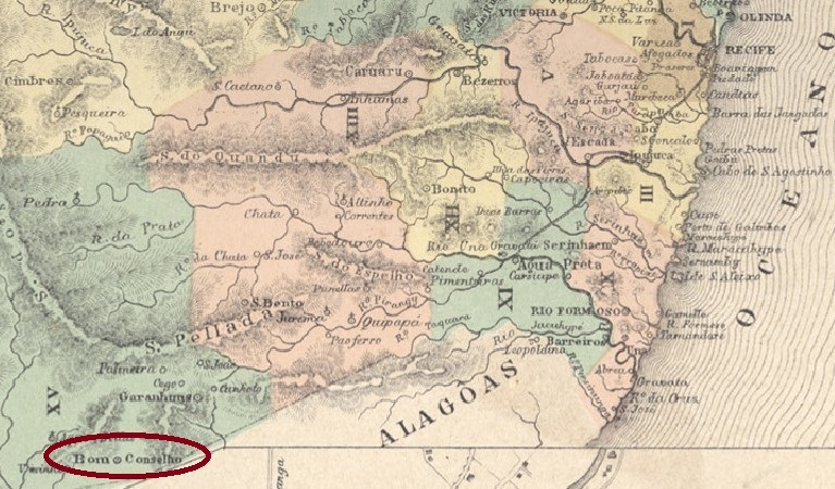
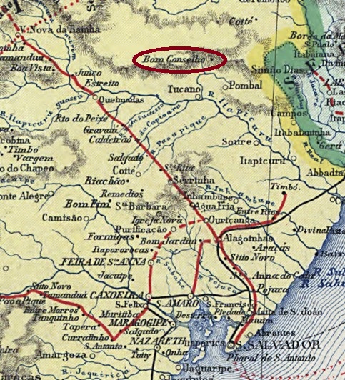
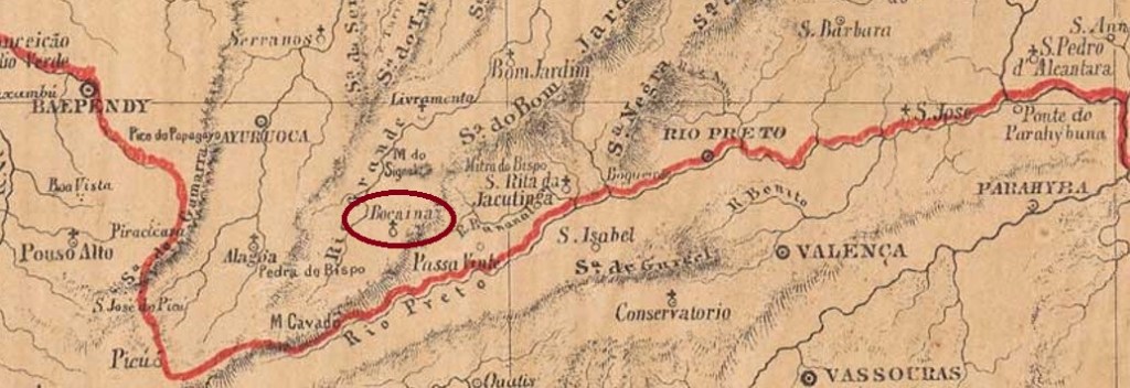
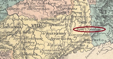
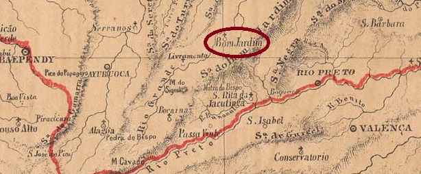
The Arraial of Senhor Bom Jesus do Bom Jardim (Good Lord Jesus of the Beautiful Garden) was founded in May 1856 and was located on the east bank of the Rio Grande, 300 km south of the provincial capital Ouro Preto. The settlement was declared a district in September 1923 and gained its autonomy in December 1938. Five years later, the Município was renamed Bom Jardim de Minas, probably to avoid confusion with places of the same name from other states. 

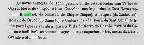
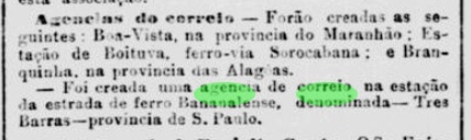
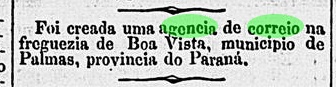
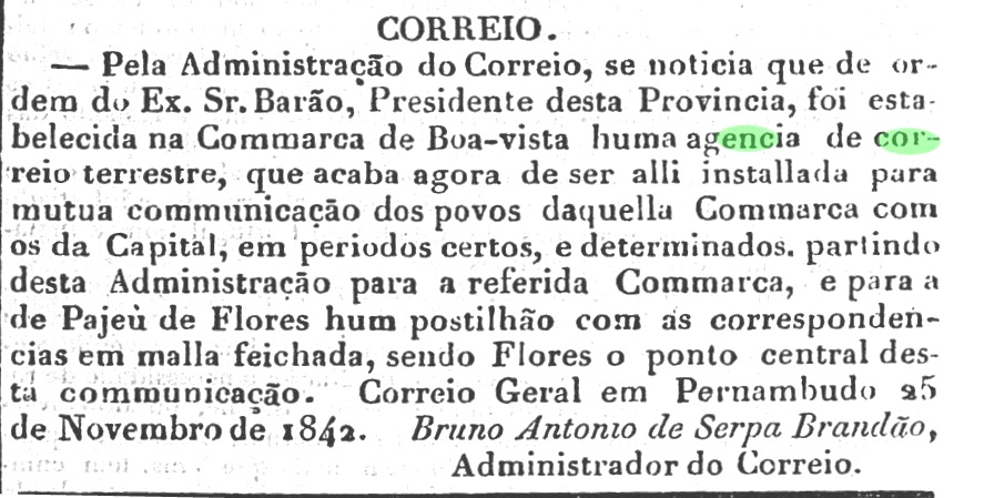
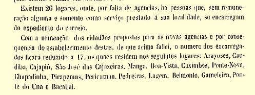
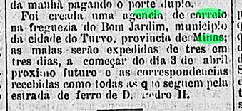
As for the origin of the local post office, all sources agree on a date of May 1879. However, as the Rio press reported, the agency would start operating only in April of the following year:

Gazeta de Noticias/RJ, 25.03.1880

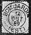
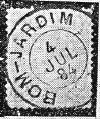
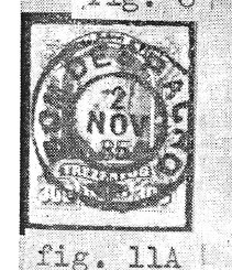
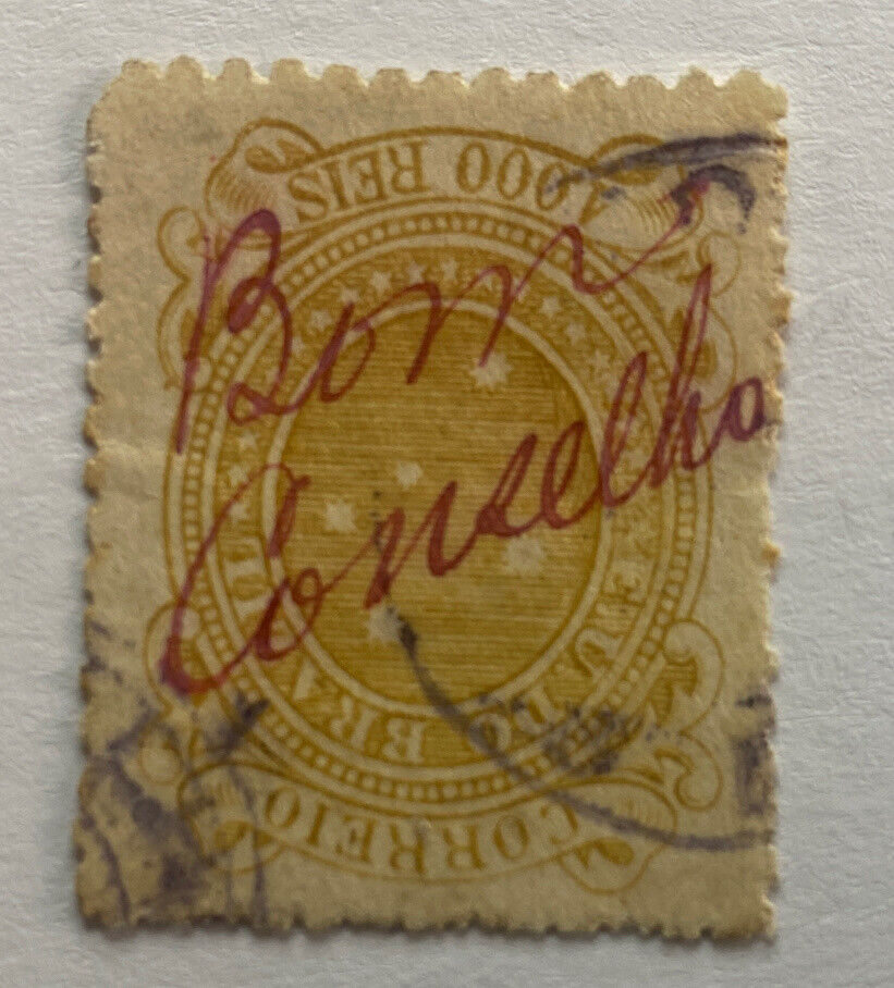
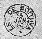
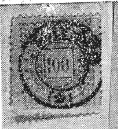
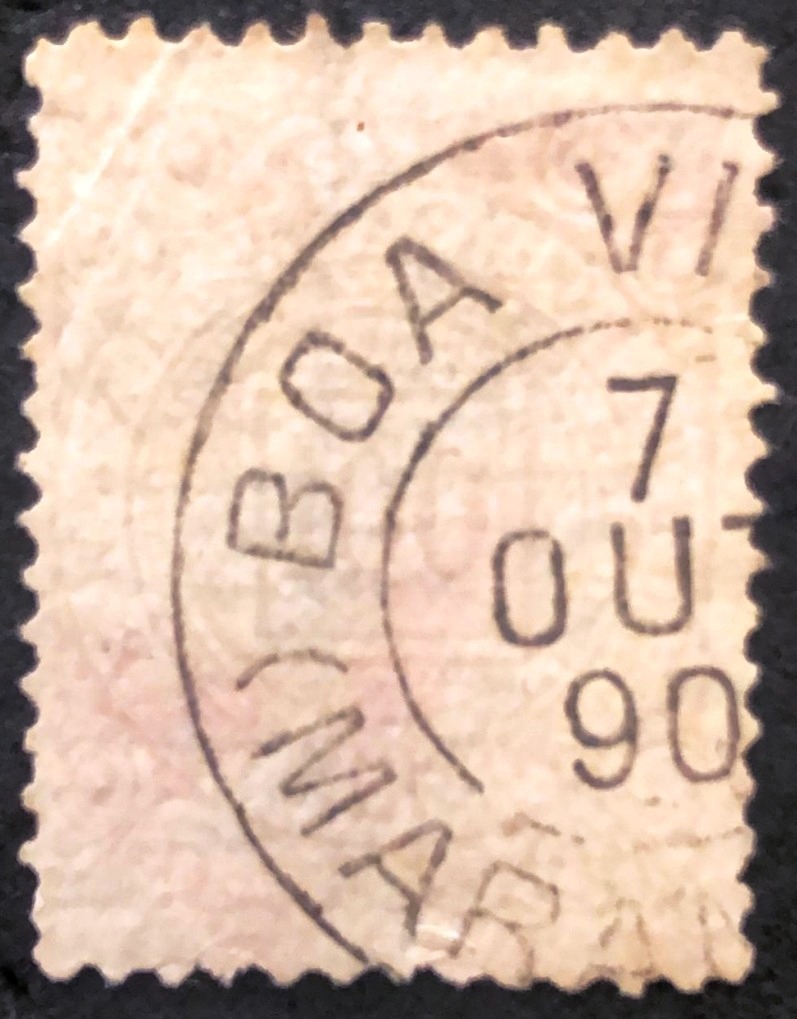
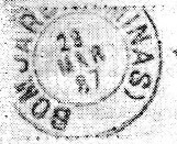
The only postmark of the imperial period so far is BMG-0330a, which was found with internal dates between 1885 and at least 1891 and was already shown by R. Koester in Carimbologia V:

BMG-0330a (RK) 1885-1891ff
provincia de Minas Geraes, 1873

Anderer Name: Bom Jardim de Minas (1943)

Der Arraial von Senhor Bom Jesus do Bom Jardim (Guter Herr Jesus aus dem Schönen Garten) wurde im Mai 1856 gegründet und lag am Ostufer des Rio Grande, 300 km südlich der Provinzhauptstadt Ouro Preto entfernt. Die Siedlung wurde im September 1923 zum Distrikt erklärt und erlangte seine Eigenständigkeit im Dezember 1938. Fünf Jahre später wurde der Município zu Bom Jardim de Minas umbenannt, wohl um Verwechslungen mit gleichnamigen Orten aus anderen Bundesstaaten zu vermeiden.  

Was die Entstehung des lokalen Postamts betrifft, sind sich zwar alle Quellen über ein Datum aus Mai 1879 einig. Allerdings berichtete die Presse aus Rio, dass die Agentur erst im folgenden April ihren Betrieb aufnahm:

Gazeta de Noticias/RJ, 25.03.1880

Der bisher einzige Poststempel der Kaiserzeit ist BMG-0330a, der mit inneren Daten zwischen 1885 und mindestens 1891gefunden wurde und bereits durch R. Koester in Carimbologia V bekannt ist:

BMG-0330a (RK) 1885-1891ff
Categories
Carimbologia A-B

Bom Jardim (train station/Bahnhof), Rio de Janeiro (BRJ-0195)

Almanak Laemmert, 1892

Another name: Vergel (1943-1947)

Bom Jardim station was inaugurated in March 1875 by the E.F. do Cantagallo railway company (Main Line) and was located on the north bank of the Rio Grande (a tributary of the Paraíba do Sul) in the Município of Nova Friburgo, 160 km northeast of the capital Rio de Janeiro. The railway line was transferred to the E.F. Leopoldina in 1887 and remained there until it was closed in 1964. Today, the rails have disappeared, and the station building is used as a notary’s office, among other things.

 in 1930 (Fig. Sandro Martins, in estacoesferroviarias.com.br)
2016 (Photo: Fernando Marietan, in estacoesferroviarias.com.br)

The settlement around the station grew rapidly. By July 1891 it had already been elevated to the status of Vila de Bom Jardim, only to be downgraded as a district of Nova Friburgo in May the following year. Seven months later it was promoted again to a Vila, which between December 1943 and June 1947 it was called Vergel.

In the Directory of Imperial Post Offices (Tabella das Agencias do Correio do Imperio, Rio de Janeiro, 1885), the local post office is listed as having originated in 1877. Two postmarks have been found for the imperial period, both of which can be seen in Koestner’s Carimbologia V. BRJ-0195a has so far dates from the period 1881-1887:

BRJ-0195a (RK) 1881-1887

BRJ-0195b was seen with inner dates from 1889 to 1893:

BRJ-0195b (RK) 1889-1893
agenciaspostais.com.br

Anderer Name: Vergel (1943-1947)

Der Bahnhof Bom Jardim wurde im März 1875 durch die Bahngesellschaft E.F. do Cantagallo (Hauptlinie) eingeweiht und lag am Nordufer des Rio Grande (ein Zufluss des Paraíba do Sul) im Município von Nova Friburgo, 160 km nordöstlich der Hauptstadt Rio de Janeiro entfernt. Die Bahnlinie ging 1887 zur E.F. Leopoldina über und blieb dort bis zur Stilllegung 1964. Heute sind die Schienen weg, das Bahnhofsgebäude dient u.a. als Notariat.

 1930 (Abb. Sandro Martins, in estacoesferroviarias.com.br)
2016 (Foto: Fernando Marietan, in estacoesferroviarias.com.br)

Die Siedlung um den Bahnhof wuchs schnell. Im Juli 1891 wurde sie bereits zur Vila de Bom Jardim erhoben, um im Mai des folgenden Jahres als Distrikt von Nova Friburgo herabgestuft zu werden. Sieben Monate später erfolgte der Wiederaufstieg zu einer Vila, die zwischen Dezember 1943 und Juni 1947 Vergel hieß.

ImVerzeichnis der kaiserlichen Postämter (Tabella das Agencias do Correio do Imperio, Rio de Janeiro, 1885) wird das örtliche Postamt mit Entstehungsjahr 1877 aufgelistet. Zwei Poststempel wurden für die Kaiserzeit gefunden, beide sind in Koestners Carimbologia V zu sehen. BRJ-0195a hat bisher Daten aus dem Zeitraum 1881-1887 vorzuweisen:

BRJ-0195a (RK) 1881-1887

BRJ-0195b wurde mit inneren Daten von 1889 bis 1893 gesehen:

BRJ-0195b (RK) 1889-1893
Categories
Carimbologia A-B

Bom Despacho, Minas Gerais (BMG-0325)

Atlas do Imperio do Brasil, 1868

Text update of July 9, 2025

Another name: N. Sra. do Bom Despacho do Picão

The district of Nossa Senhora do Bom Despacho do Picão was founded in July 1832 and was in the Município of Santo Antonio do Monte, 250 km northwest of the provincial capital of Ouro Preto. The Picão River originated there and flows 80 km to its mouth on the west bank of the Pará. The village became a freguesia in July 1864, a vila in August 1911 and a town in September 1933.

As Nova Monteiro writes in Administrações e Agencias Postaes do Brasil Imperio (Brasil Filatelico/RJ, 1934-5; Reprint SPP 1994-1999), the local post office was established in October 1867. The oldest postmark from the imperial era to date is BMG-0325b (RK), which was seen with dates from 1885 to 1886 and was already registered in Koester’s Carimbologia V:

BMG-0325b (RK) 1885-1886

This was followed by BMG-0325c (Fig. Luiz C. Fritzen), which looks similar to its predecessor:

BMG-0325c (LCF) 1886-1905
Villiers de l’Ile Adam: Carta (…) da Provincia de Minas Geraes, 1849

Textaktualisierung am 9. Juli 2025

Anderer Name: N. Sra. do Bom Despacho do Picão

Der Distrikt von Nossa Senhora do Bom Despacho do Picão wurde im Juli 1832 gegründet und lag im Município von Santo Antonio do Monte, 250 km nordweestlöich der Provinzhauptstadt Ouro Preto entfernt. Der Picão-Fluss hat dort seinen Ursprung und fließt 80 km bis zur Mündung am Westufer des Pará. Der Ort wurde im Juli 1864 zur Freguesia, im August 1911 zur Vila und im September 1933 zur Stadt.

Wie Nova Monteiro in Administrações e Agencias Postaes do Brasil Imperio (Brasil Filatelico/RJ, 1934-5; Reprint SPP 1994-1999) schreibt, wurde das örtliche Postamt im Oktober 1867 ins Leben gerufen. Der bisher älteste Poststempel der Kaiserzeit ist BMG-0325b (RK), der mit Daten von 1885 bis 1886 gesehen wurde und bereits in Koesters Carimbologia V registriert wurde:

BMG-0325b (RK) 1885-1886

Es folgte BMG-0325c (Abb. Luiz C. Fritzen), der seinem Vorgänger ähnlich aussieht:

BMG-0325c (LCF) 1886-1905

Categories
Carimbologia A-B

Bom Conselho, Pernambuco (BPE-0115)

Villiers de l’Ile Adam: Carta (…) das Provincias de Pernambuco, Alagoas e Sergipe, 1848

Another name: Papacaça

The Freguesia of Jesus, Maria e José de Papacaça (Jesus, Mary, and Joseph at the Wild Eater) was founded in June 1837 and was located at the Vila of Correntes, 280 km southwest of the provincial capital Recife. The strange name derives from Pedro Papa-Caça, a flown slave who founded a quilombo on place around 1630. It was promoted to Vila in June 1848, yet it was downgraded as a Freguesia just one year later. It was not until April 1860 that vila status returned, this time under the more civil name of Bom Conselho. Bom Conselho has been a town since June 1898.

As Nova Monteiro writes in Administrações e Agencias Postaes do Brasil Imperio (Brasil Filatelico/RJ, 1934-5; Reprint SPP 1994-1999), there was a post office there since October 1862. The only postmark of the imperial period so far is the French type BPE-0115b, already shown by R. Koester in Carimbologia V:

BPE-0115b (RK) 1882ff
Atlas do Imperio do Brasil, 1868

Anderer Name: Papacaça

Die Freguesia von Jesus, Maria e José de Papacaça (Jesus, Maria und Joseph beim Wildesser) wurde im Juni 1837 gegründet und lag bei der Vila von Correntes, 280 km südwestlich der Provinzhauptstadt Recife. Der eigentümliche Name soll von Pedro Papa-Caça kommen, ein geflohener Sklave, der um 1630 dort ein Quilombo gegründet hatte. Der Aufstieg zur Vila erfolgte im Juni 1848, dennoch wurde der Ort gleich ein Jahr später als Freguesia wieder herabgestuft. Erst im April 1860 kam der Vila-Status zurück, diesmal unter dem zivileren Namen Bom Conselho. Seit Juni 1898 ist Bom Conselho eine Stadt.

Wie Nova Monteiro in Administrações e Agencias Postaes do Brasil Imperio (Brasil Filatelico/RJ, 1934-5; Reprint SPP 1994-1999) schreibt, gab es dort ein Postamt seit Oktober 1862. Der bisher einzige Poststempel der Kaiserzeit ist der französische Typus BPE-0115b, der bereits von R. Koester in Carimbologia V gezeigt wurde:

BPE-0115b (RK) 1882ff
Categories
Carimbologia A-B

Bom Conselho, Bahia (BBA-0130)

Atlas do Imperio do Brasil, 1868

Another name: Cicero Dantas (1905)

The Freguesia of N. Sra. do Bom Conselho dos Montes do Boqueirão was founded in November 1817, belonged to the Vila of Jeremoabo and was located 320 km north of the later provincial capital Salvador da Bahia. In June 1875, the village became a vila, which was renamed Município of Cicero Dantas in May 1905. The name commemorates Cicero Dantas Martins (1838-1903), a local-born politician and large landowner who introduced industrial sugar production to Brazil’s northeast. The town was downgraded as a district of Paripiranga in June 1931, but regained município status in May 1933.

Cicero Dantas Martins, Baron of Jeremoabo

As Reinhold Koester writes in Carimbologia V, there had been a post office there since August 1876, which is confirmed by the provincial president’s report the following year:

Relatorio do Conselho Interino do Governo da Bahia, 1877

The only postmark of the imperial period so far is BBA-0130b (illustration from the internet): a double circle with the inscription BOM CONSELHO at the top. The only specimen so far shows (in blue) only its right half and was found on a numeral issue from 1888. A beautiful handwritten cancellation also appears at the beginning of the Republic (Coll. Roberto Assef Jr.):

1890ff (RA)
Anderer Name: Cicero Dantas (1905)

Die Freguesia von N. Sra. do Bom Conselho dos Montes do Boqueirão wurde im November 1817 gegründet, gehörte der Vila von Jeremoabo und lag 320 km nördlich der späteren Provinhzauptstadt Salvador da Bahia. Im Juni 1875 wurde aus der Ortschaft eine Vila, die ab Mai 1905 als Município von Cicero Dantas umbenannt wurde. Der Name erinnert an Cicero Dantas Martins (1838-1903), einem in der Gegend geborenen Politiker und Großgrundbesitzer, der die industrielle Zuckerproduktion in Brasiliens Nordosten eingeführt hatte. Der Ort wurde im Juni 1931 als Distrikt von Paripiranga herabgestuft, erlangte jedoch im Mai 1933 wieder den Município-Status.

Cicero Dantas Martins, Baron von Jeremoabo

Wie Reinhold Koester in Carimbologia V schreibt, gab es dort ein Postamt seit August 1876. Das wird durch den Bericht des Provinzpräsidenten im folgenden Jahr bestätigt:

Relatorio do Conselho Interino do Governo da Bahia, 1877

Der bisher einzige Poststempel der Kaiserzeit ist BBA-0130b (Abbindung aus dem Internet): ein Doppelkreis mit der Inschrift BOM CONSELHO oben. Das bisher einzige Exemplar zeigt (in Blau) nur seine rechte Hälfte und wurde auf einer Zifferausgabe aus 1888 gefunden. Am Anfang der Republik erscheint auch eine schöne handschriftliche Entwertung (Samml. Roberto Assef Jr.):

1890ff (RA)
Categories
Carimbologia A-B

Boituva (train station/Bahnhof), São Paulo (BSP-0160)

Cia. Sorocabana e Ytuana, 1898

Boituva station was inaugurated in July 1882 by the E.F. Sorocabana railway company (main line) in the Município of Porto Feliz, 120 km west of the provincial capital São Paulo. The railway line changed hands in 1892 to the Cia. União Sorocabana e Ytuana, in 1907 to the Sorocabana Railway, in 1919 back to the E.F. Sorocabana, and from 1971 until its closure in 1998 it belonged to FEPASA (estacoesferroviarias.com.br).

The rails are still there today, the old station building was demolished, and since 1933 there has been a new one, which now houses Alcoholics Anonymous.

Ca. 1920 (Photo: Miguel Saad in estacoesferroviarias.com.br)
2017 (Photo: Rafael Asquini in estacoesferroviarias.com.br)

The settlement around the station continued to grow, becoming a district of Porto Feliz in 1906, and Boituva has been an independent município since September 1938. There was a station post office from February 1889, according to the Rio Press:

Jornal do Commercio/RJ, 01/03/1889

The first postmark here is BSP-0160a and has already been made known by R., Koester in Carimbologia V:

BSP-0160a (RK) 1890
Arthur D. Ribeiro: Estado de São Paulo, 1924

Der Bahnhof Boituva wurde im Juli 1882 durch die Bahngesellschaft E.F. Sorocabana (Hauptlinie) eingeweiht und lag im Município von Porto Feliz, 120 km westlich der Provinzhauptstadt São Paulo entfernt. Die Bahnlinie wechselte 1892 zur Cia. União Sorocabana e Ytuana, 1907 zur Sorocabana Railway, 1919 zurück zur E.F. Sorocabana, und von 1971 bis zur Stilllegung 1998 gehörte sie der FEPASA (estacoesferroviarias.com.br).

Die Schienen sind bis heute noch da, das alte Bahnhofsgebäude wurde abgerissen, seit 1933 gibt es ein neues, das heute die Anonymen Alkoholiker beherbergt.

Ca. 1920 (Foto: Miguel Saad in estacoesferroviarias.com.br)
2017 (Foto: Rafael Asquini in estacoesferroviarias.com.br)

Die Siedlung um den Bahnhof wuchs weiter, sie wurde 1906 zum Distrikt von Porto Feliz, und Boituva ist ein eigenständiger Município seit September 1938. Einen Bahnhofspostamt gab es ab Februar 1889, wie aus der Rio-Presse entnommen wird:

Jornal do Commercio/RJ, 01.03.1889

Der erste Poststempel hier ist BSP-0160a und wurde bereits durch R., Koester in Carimbologia V bekannt gemacht:

BSP-0160a (RK) 1890
Categories
Carimbologia A-B

Bocaina, Minas Gerais (BMG-0315)

Atlas do Imperio do Brasil, 1868

Other names: Bocaina de Aiuruoca, Arimateia, Bocaina de Minas (1953)

The parish of N. Sra. do Rosario de Bocaina was established in May 1858 and was in the Município of Aiuruoca, 340 km southwest of the provincial capital Ouro Preto. In December 1938, the locality changed as a district to the Município of Liberdade. Five years later, it changed again, this time to Arimateia. Since December 1953, the village has been an independent município called Bocaina de Minas.

The local post office was established in October 1881, according to the capital’s press:

Gazeta da Tarde/RJ, 11/10/1881

The first postmark would be BMG-0315a, as described in R. Koester’s Carimbologia, unfortunately without illustration: a double circle with the inscription BOCAINA on top and inner date from 1890.

Provincia de Minas Geraes, 1877

Andere Namen: Bocaina de Aiuruoca, Arimateia, Bocaina de Minas (1953)

Die Pfarrei von N. Sra. do Rosario de Bocaina wurde im Mai 1858 errichtet und lag im Município von Aiuruoca, 340 km südwestlich der Provinzhauptstadt Ouro Preto entfernt. Im Dezember 1938 wechselte die Ortschaft als Distrikt zum Município von Liberdade. Fünf Jahre später wieder ein Wechsel, diesmal zu Arimateia. Seit Dezember 1953 ist der Ort ein eigenständiger Município namens Bocaina de Minas.

Das örtliche Postamt entstand im Oktober 1881, wie aus der Hauptstadtpresse hervorgeht:

Gazeta da Tarde/RJ, 11.10.1881

Der erste Poststempel wird BMG-0315a sein, wie in R. Koesters Carimbologia beschrieben, leider ohne Abbildung: ein Doppelkreis mit der Inschrift BOCAINA oben und innerem Datum aus 1890.

Categories
Carimbologia A-B

Boa Vista, Paraná (BPR-0025)

Carta da Republica dos Estados Unidos do Brazil, 1892

Another name: Clevelândia (1909)

The freguesia of N. Sra. da Luz da Boa Vista was founded in October 1884, close to the present-day border with Santa Catarina, in the Município of Palmas, more than 400 km southwest of the provincial capital Curitiba. In June 1892, it was promoted to a vila, which was called Clevelândia from March 1909. The name is a reverence to former USA President Grover Cleveland (1837-1908). In 1895, the latter had presided over an arbitration that declared the entire territory in western Paraná as Brazilian. Between 1943 and 1946, the Município belonged to the now extinguished Território of Iguaçu.

The local post office was established in October 1887, according to the Rio press:

Diario de Noticias/RJ, 28/10/1887

No imperial postmark from Boa Vista/PR has been seen so far.

Estado do Paraná, 1896

Anderer Name: Clevelândia (1909)

Die Freguesia von N. Sra. da Luz da Boa Vista wurde im Oktober 1884 gegründet und lag nah an der heutigen Landesgrenze zu Santa Catarina, im Município von Palmas, über 400 km südwestlich der Provinzhauptstadt Curitiba entfernt. Im Juni 1892 erfolgte der Aufstieg zu einer Vila, die ab März 1909 Clevelândia hieß. Der Name soll dem ehemaligen USA-Präsident Grover Cleveland (1837-1908) eine Reverenz erweisen. Dieser hatte 1895 eine Schlichtung geleitet, die das gesamte Gebiet im Westen Paranás als brasilianisch erklärte. Zwischen 1943 und 1946 gehörte der Município dem inzwischen verschwundenen Território von Iguaçu.

Das örtliche Postamt wurde im Oktober 1887 ins Leben gerufen, wie aus der Rio-Presse zu entnehmen ist:

Diario de Noticias/RJ, 28.10.1887

Bisher wurde kein kaiserlicher Poststempel aus Boa Vista/PR gesehen.

Categories
Carimbologia A-B

Boa Vista, Pernambuco (BPE-0110)

Atlas do Imperio do Brasil, 1868

Other names: Coripós, Santa Maria da Boa Vista (1953)

The freguesia of Santa Maria da Boa Vista was founded as early as January 1762 and was located on the north bank of the São Francisco, 600 km west of the later provincial capital Recife. The village was promoted to vila three times: in April 1838, in May 1864 and in June 1872. In between – more precisely in June 1862 and in May 1870 – Boa Vista was downgraded as Freguesia in the Município of Petrolina. The locality has been a town since July 1909, after which the place name changed twice: in December 1943 to Coripós (after an Indian tribe of the region) and ten years later to Santa Maria da Boa Vista, which is still valid today.

Two dates of origin for the local post office have been found. First in March 1829, as Nova Monteiro writes in Administrações e Agencias Postaes do Brasil Imperio (Brasil Filatelico/RJ, 1934-5; Reprint SPP 1994-1999). Then in November 1842, as can be seen from the regional press:

Diario Novo, 26.11.1842

The only postmark in the empire so far is BPE-0110b (Coll. Marco Morel): a French type, with the inscription BÔA VISTA at the top and the asterisk between brackets at the bottom. Found for the period 1885-1890. Hier the illustration from Koerster’s Carimbologia V:

(RK) 1888ff
Crata Corographica da Provincia de Pernambuco, 1880

Andere Namen: Coripós, Santa Maria da Boa Vista (1953)

Die Freguesia von Santa Maria da Boa Vista wurde bereits im Januar 1762 gegründet und lag am Nordufer des São Francisco, 600 km westlich der späteren Provinzhauptstadt Recife entfernt. Die Ortschaft stieg dreimal zur Vila auf: im April 1838, im Mai 1864 und im Juni 1872. Zwischendurch – genauer im Juni 1862 und im Mai 1870 – wurde Boa Vista als Freguesia im Município von Petrolina herabgestuft. Die Ortschaft ist eine Stadt seit Juli 1909, danach änderte sich der Ortsname zweimal: im Dezember 1943 zu Coripós (nach einem Indianerstamm der Region) und zehn Jahre später zum heute noch gültigen Santa Maria da Boa Vista.

Es wurden zwei Entstehungsdaten fürs örtliche Postamt gefunden. Erstmals im März 1829, wie Nova Monteiro in Administrações e Agencias Postaes do Brasil Imperio (Brasil Filatelico/RJ, 1934-5; Reprint SPP 1994-1999) schreibt. Dann im November 1842, wie aus der Regionalpresse hervorgeht:

Diario Novo, 26.11.1842

Der bisher einzige Poststempel im Kaiserreich ist BPE-0110b (Samml. Marco Morel): ein französischer Typus, mit der Inschrift BÔA VISTA oben und dem Sternchen zwischen Klammern unten. Gefunden für die Periode 1885-1890. Hier die Abbildung aus Koesters Carimbologia V:

(RK) 1888ff
Categories
Carimbologia A-B

Boa Vista, Maranhão (BMA-0050)

Atlas do Imperio do Brasil, 1868

Text update of March 4, 2024

In the imperial province of Maranhão, there were at least three villages called Boa Vista. This was a small settlement belonging to the Vila of Monção, located on the west bank of the Pindaré River, 350 km southwest of the provincial capital São Luís. The place was much more important at that time than it is today, due to the agricultural colony of S. Pedro de Alcantara there was a lot of shipping traffic along the Pindaré. Boa Vista became a district around 1890, changing to the município of Santa Luzia in December 1959. Since November 1994, the village has been a rural suburb in the município of Alto Alegre do Pindaré.

According to the Rio Press, there was a post office there from February 1889:

Jornal do Commercio/RJ, 01.03.1889

However, there was already postal services on site in 1875, carried out by volunteers, as can be read in the report of the provincial president from February of that year.

Relatorio do Presidente da Provincia, February 1875 (p. 42)

The oldest postmark so far from Boa Vista is BMA-0050a (image: Felipe Piccinini):

BMA-0050a (FP) 1890
Crata da Republica dos Estados Unidos do Brazil, 1892

Textaktualisierung am 4. März 2024

In der kaiserlichen Provinz Maranhão soll es mindestens drei Ortschaften gegeben haben, die Boa Vista hießen. Diese war eine kleine Siedlung, die der Vila von Monção gehörte und am Westufer des Flusses Pindaré lag, 350 km südwestlich der Provinzhauptstadt São Luís entfernt. Der Ort war damals wesentlich wichtiger als heute, denn durch die Landwirtschafts-Kolonie S. Pedro de Alcantara bestand auch regen Schiffsverkehr entlang des Pindarés. Boa Vista wurde ca. 1890 ein Distrikt, der im Dezember 1959 zum Município von Santa Luzia wechselte, seit November 1994 ist die Ortschaft ein ländlicher Vorort im Município von Alto Alegre do Pindaré.

Wie aus der Rio-Presse hervorgeht, gab es dort ein Postamt ab Februar 1889:

Jornal do Commercio/RJ, 01.03.1889

Allerdings gab es bereits 1875 Postdienste vor Ort, von Ehrenamtlichen durchgeführt, wie im Bericht des Provinzpräsidenten im Februar d. Js. zu lesen ist.

Relatorio do Presidente da Provincia, Februar 1875 (S. 42)

Der bisher älteste Poststempel aus Boa Vista ist BMA-0050a (Abb. Felipe Piccinini):

BMA-0050a (FP) 1890