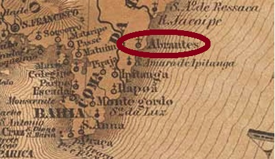
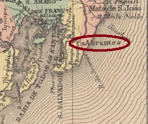
Villiers de l’Ile Adam: Carta (…) da Provincia da Bahia, 1848
Another name: Montenegro (1925-1938)
Villa do Espírito Santo de Nova Abrantes was built as early as September 1758 and was located on the Atlantic Ocean, 35 km northeast of the former colonial capital Salvador da Bahia. In April 1846, the place was demoted to a freguesia in the Município of Mata de São João, but regained villa status two years later. In July 1925, the place name changed to Montenegro, and in March 1938, the old name returned, but as a district in the Município of Camaçari. And so it has remained until today.
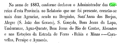
The local post office was established in 1883, as can be seen from the report of the Bahia government council for the following year:
Relatório do Conselho Interino do Governo da Bahia, 1884
So far, no imperial postmark from this place has appeared.
Atlas do Imperio do Brasil, 1868
Anderer Name: Montenegro (1925-1938)
Die Villa do Espírito Santo de Nova Abrantes wurde bereits im September 1758 errichtet und lag am Atlantik, 35 km nordöstlich der früheren Kolonialhauptstadt Salvador da Bahia entfernt. Im April 1846 wurde der Ort zur Freguesia im Município von Mata de São João degradiert, doch erlangte zwei Jahre später den Villa-Status wieder. Im Juli 1925 änderte sich der Ortsname zu Montenegro, und im März 1938 kehrte der alte Name zurück, allerdings als ein Distrikt im Município von Camaçari. Und so ist es bis heute geblieben.
Das örtliche Postamt entstand 1883, wie aus der Bericht des Regierungsrats in Bahia fürs darauf folgende Jahr hervorgeht:
Relatório do Conselho Interino do Governo da Bahia, 1884
Bisher ist kein kaiserlicher Poststempel aus diesem Ort aufgetaucht.
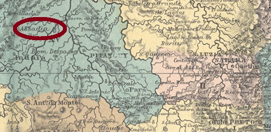
Other names: Abbadia de Pitanguy, Martinho Campos (1938)
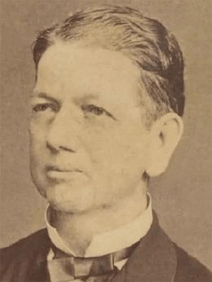
The chapel of Nossa Senhora da Abbadia was built around 1814 and was located on the Picão River, a good 70 km from the villa of Pitangui and over 270 km from the later provincial capital Ouro Preto. In June 1858, the place was elevated to a freguesia. In September 1923, the official place name changed to Abbadia de Pitanguy, and since December 1938 it has been the Município of Martinho Campos. The name commemorates Martinho Álvares da Silva Campos (1816-1887), doctor, senator and provincial president of Rio de Janeiro, who was born in Pitangui:
Instituto Histórico e Geográfico de Minas Gerais
Two years of origin for the local post office were found. Firstly in 1873, as recorded in the Directory of Imperial Post Offices (Tabella das Agencias do Correio do Imperio, Rio de Janeiro, 1885). Then in November 1878, as Paula Sobrinho writes in História Postal de Minas Gerais (Belo Horizonte, 1997). A postmark is registered in the 19th century, unfortunately not the oldest: AMG-0010b is a double circle with the inscription ABBADIA DE PITANGUY on top. The only specimen bears a date from 1895 inside.
Provincia de Minas Geraes, 1873
Andere Namen: Abbadia de Pitanguy, Martinho Campos (1938)
Die Kapelle von Nossa Senhora da Abbadia wurde ca. 1814 errichtet und lag am Fluss Picão, gut 70 km von der Villa von Pitangui und über 270 km von der späteren Provinzhauptstadt Ouro Preto entfernt. Im Juni 1858 wurde der Ort zu einer Freguesia erhoben. Im September 1923 wechselte der amtliche Ortsname zu Abbadia de Pitanguy, und seit Dezember 1938 ist er der Município von Martinho Campos. Der Name erinnert an Martinho Álvares da Silva Campos (1816-1887), Arzt, Senator und Provinzpräsidenten von Rio de Janeiro, der in Pitangui geboren war:
Instituto Histórico e Geográfico de Minas Gerais
Zwei Entstehungsjahre fürs örtliche Postamt wurden gefunden. Erstmals 1873, wie im Verzeichnis der kaiserlichen Postämter (Tabella das Agencias do Correio do Imperio, Rio de Janeiro, 1885) zu lesen ist. Dann im November 1878, wie Paula Sobrinho in História Postal de Minas Gerais (Belo Horizonte, 1997) schreibt. Ein Poststempel ist im 19. Jahrhundert registrieret, leider nicht der älteste: AMG-0010b ist ein Doppelkreis mit der Inschrift ABBADIA DE PITANGUY oben. Das einzige Exemplar trägt ein Datum aus 1895 im Inneren.
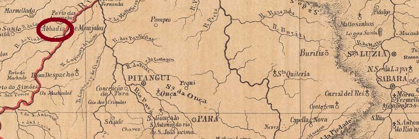
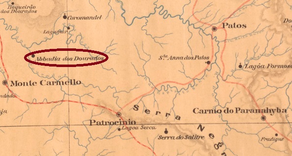
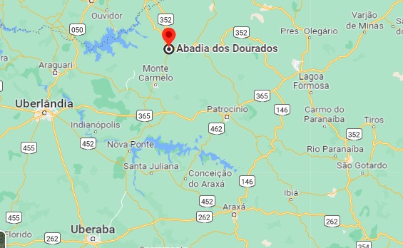
The Freguesia of Nossa Senhora da Abbadia dos Dourados was created in September 1882 in the Município of Patrocínio, located on the north bank of the Dourados River, 600 km northwest of the provincial capital Ouro Preto. The following month, it was transferred to the newly formed Município of Coromandel, then returned to Patrocínio in November 1891, before changing again as a district of Coromandel in September 1923. Since December 1948, Abadia dos Dourados (as it is written today) has been an independent Município.
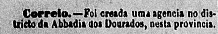
Two dates of origin for the local post office have been found. First in November 1878, as Paula Sobrinho writes in História Postal de Minas Gerais (Belo Horizonte, 1997). Then again in December 1884, as reported in the regional press:
O Baependyano, 28.12.1884
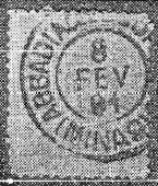
The only 19th century postmark so far is probably from the second period of operation. AMG-0020b was already presented by Reinhold Koester in Carimbologia I (1961):
AMG-0020b (RK) 1891Google Maps
Die Freguesia von Nossa Senhora da Abbadia dos Dourados wurde im September 1882 im Município von Patrocínio ins Leben gerufen und lag am Nordufer des Flusses Dourados, 600 km nordwestlich der Provinzhauptstadt Ouro Preto entfernt. Gleich im folgenden Monat wechselte der Ort zum neu gegründeten Município von Coromandel, kehrte dann im November 1891 zu Patrocínio zurück, bevor im September 1923 ein abermaliger Wechsel als Distrikt von Coromandel stattfand. Seit Dezember 1948 ist Abadia dos Dourados (wie heute geschrieben wird) ein eigenständiger Município.
Zwei Entstehungsdaten fürs örtliche Postamt wurden gefunden. Erstmals im November 1878, wie Paula Sobrinho in História Postal de Minas Gerais (Belo Horizonte, 1997) schreibt. Dann wieder im Dezember 1884, wie die Regionalpresse berichtete:
O Baependyano, 28.12.1884
Der bisher einzige Poststempel im 19. Jahnhundert kommt wohl aus der zweiten Betriebsperiode. AMG-0020b wurde bereits durch Reinhold Koester in Carimbologia I (1961) vorgestellt:
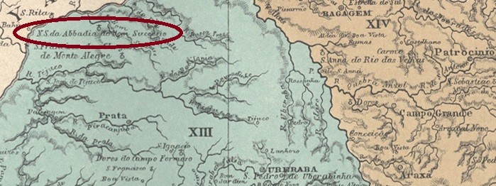
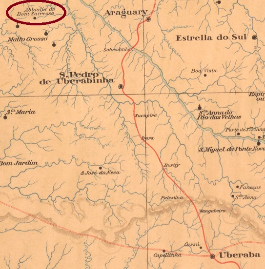
The Freguesia of Nossa Senhora da Abbadia do Bom Successo was created in October 1851 and was located at the Villa of Uberaba, 700 km west of the provincial capital of Ouro Preto. In June 1858, the place changed as a district to the then freshly created Município of Monte Alegre (today: Monte Alegre de Minas) and became a villa in November 1911, which was given the name Tupaciguara in September 1923. The word from the Tupi-Guarani language means Land of the Mother of God. Tupaciguara has been a town since September 1925.
There was a post office there from August 1885, as Paula Sobrinho writes in História Postal de Minas Gerais (Belo Horizonte, 1997). The oldest postmark so far is AMG-0015a (Coll. Márcio Protzner): a double circle with the inscriptions ABBADIA DO BOM SUCCESSO above and (MINAS) below. The internal dates are from the period 1897-1904.
Estado de Minas Geraes, 1910
Textaktualisierung am 20. August 2022
Anderer Name: Tupaciguara (1923)
Die Freguesia von Nossa Senhora da Abbadia do Bom Successo wurde im Oktober 1851 ins Leben gerufen und lag bei der Villa von Uberaba, 700 km westlich der Provinzhauptstadt Ouro Preto entfernt. Im Juni 1858 wechselte der Ort als Distrikt zum damals frisch entstandenen Município von Monte Alegre (heute: Monte Alegre de Minas) und wurde im November 1911 eine Villa, die im September 1923 den Namen Tupaciguara bekam. Das Wort aus der Tupi-Guarani-Sprache bedeutet Land der Mutter Gottes. Seit September 1925 ist Tupaciguara eine Stadt.
Dort gab es ein Postamt ab August 1885, wie Paula Sobrinho in História Postal de Minas Gerais (Belo Horizonte, 1997) schreibt. Der bisher älteste Poststempel ist AMG-0015a (Samml. Márcio Protzner): ein Doppelkreis mit den Inschriften ABBADIA DO BOM SUCCESSO oben und (MINAS) unten. Die Daten entstammen dem Zeitraum 1897-1904.
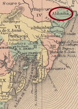
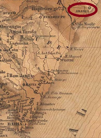
Other names: Arraial da Cachoeira, Jandaíra (1927)
The chapel of Nossa Senhora da Abbadia was built as early as 1718, located 200 km north of the former colonial capital Salvador da Bahia, close to the border with Sergipe. In April 1728, it rose to the status of a villa, and in June 1880 it was given the name Arraial da Cachoeira. In August 1927, it became the Villa of Jandaíra.
Two dates of origin for the local post office have been recorded. The first was in October 1851, as Nova Monteiro notes in Administrações e Agencias Postaes do Brasil Imperio (Brasil Filatelico/RJ, 1934-5; Reprint SPP 1994-1999), and confirmed by the report of the Imperial Ministry of the same year:
Relatorio do Ministerio do Imperio, 1851
The second post office creation took place in 1859, as can be read in the Directory of Imperial Post Offices (Tabella das Agencias do Correio do Imperio, Rio de Janeiro, 1885).
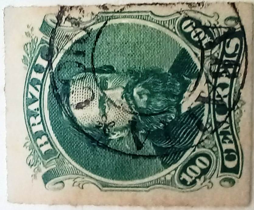
The oldest postmark from the imperial era to date is ABA-0010a (collect. Fuad Ferreira Fo.), which was found on stamp issues between 1850 and 1876:
ABA-0010a (FF) 1851ff-1876ff
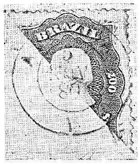
It was followed by ABA-0010b with a specimen from 1880, as presented by Reinhold Koester (Carimbologia I, 1961):
ABA-0010b (RK) 1880Villers de l’Ile Adam: Carta (…) da Provincia da Bahia, 1848
Textaktualisierung am 7. November 2023
Andere Namen: Arraial da Cachoeira, Jandaíra (1927)
Die Kapelle von Nossa Senhora da Abbadia wurde bereits 1718 errichtet und lag 200 km nördlich der früheren Kolonialhauptstadt Salvador da Bahia, nah an der Grenze zu Sergipe. Im April 1728 stieg der Ort zur Villa, die im Juni 1880 den Namen Arraial da Cachoeira bekam. Im August 1927 wurde daraus die Villa von Jandaíra.
Zwei Entstehungstermine fürs örtliche Postamt wurden registriert. Erstmals im Oktober 1851, wie Nova Monteiro in Administrações e Agencias Postaes do Brasil Imperio(Brasil Filatelico/RJ, 1934-5; Reprint SPP 1994-1999) vermerkt, und durch den damaligen Bericht des kaiserlichen Ministeriums bestätigt wurde:
Relatorio do Ministerio do Imperio, 1851
Die zweite Postamteröffnung fand 1859 statt, wie man im Verzeichnis der kaiserlichen Postämter (Tabella das Agencias do Correio do Imperio, Rio de Janeiro, 1885) lesen kann.
Der bisher älteste Poststempel aus der Kaiserzeit ist ABA-0010a (Samml. Fuad Ferreira Fo.), der auf Briefmarkenausgaben zwischen 1850 und 1876 gefunden wurde:
ABA-0010a (FF) 1851ff-1876ff
Ihm folgte ABA-0010b mit einem Exemplar von 1880, wie es von Reinhold Koester (Carimbologia I, 1961) vorgestellt wurde:
Villers de l’Ile Adam: Carta (…) das Provincias do Grão-Para e Alto Amazonas, 1850
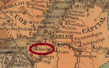
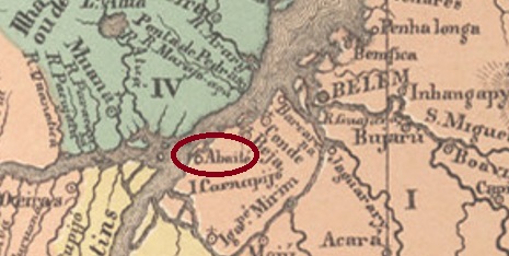
Another name: Abaetetuba (1943)
The freguesia of Nossa Senhora da Conceição do Abaeté was created in 1750, subordinate to the capitania capital of Belém do Pará, and was located on the east bank of the Maratauira River, 70 km southwest of Belém. In September 1844, the town transferred to the newly created Município of Igarapé-Mirim but returned to Belém in April 1877. In March 1880, Abaeté became a villa and in July 1895 a town, called Abaetetuba since December 1943.
According to the report of the Provincial President (Relatorio do Presidente da Provincia) of February 1881, a local post office was established shortly before. However, since in the Directory of Imperial Post Offices (Tabella das Agencias do Correio do Imperio, Rio de Janeiro, 1885) the year of origin is 1882, it probably took a while to start operations. Here, too, no postmark from the imperial period has been seen so far.
Atlas do Imperio do Brasil, 1868
Anderer Name: Abaetetuba (1943)
Die Freguesia von Nossa Senhora da Conceição do Abaeté entstand 1750, untergeordnet der Kapitanie-Hauptstadt Belém do Pará, und lag am Ostufer des Flusses Maratauira, 70 km südwestlich von Belém entfernt. Im September 1844 wechselte der Ort zum neu gegründeten Município von Igarapé-Mirim, kehrte aber im April 1877 zu Belém zurück. Im März 1880 wurde Abaeté eine Villa und im Juli 1895 eine Stadt, die seit Dezember 1943 Abaetetuba heißt.
Laut Bericht des Provinzpräsidenten (Relatorio do Presidente da Provincia) von Februar 1881 entstand kurz davor ein örtliches Postamt. Da aber im Verzeichnis der kaiserlichen Postämter (Tabella das Agencias do Correio do Imperio, Rio de Janeiro, 1885) das Entstehungsjahr 1882 zu lesen ist, hat vermutlich die Inbetriebnahme der Agentur eine Weile gedauert. Auch hier wurde bisher kein Poststempel aus der Kaiserzeit gesehen.
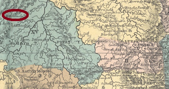
Other names: Patrocínio da Marmellada, Dores da Marmellada
See also Marmelada (R. Koester: Carimbologia XXVII)
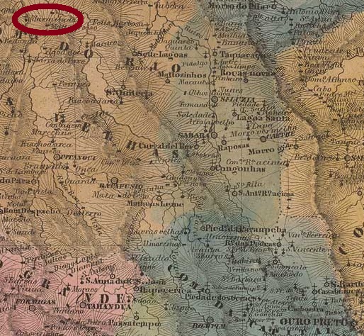
In the Tupi-guarani language, Abaeté means strong and brave man. This was also Indian tribe name that originally inhabited this area on the north bank of the Marmelada River, 300 km northwest of the provincial capital Ouro Preto. In July 1864, the settlement became the Freguesia of Nossa Senhora do Patrocínio da Marmellada, in the Município of Dores do Indayá. When in September 1870 Dores do Indayá was downgraded to a district of Pitangui, Patrocínio da Marmellada was given the status of a villa, and since November 1877 it has been the town of Abaeté.
As Paula Sobrinho writes in História Postal de Minas Gerais (Belo Horizonte, 1997), there was a post office there since June 1873, a year confirmed by the Directory of Imperial Post Offices (Tabella das Agencias do Correio do Imperio, Rio de Janeiro, 1885). Koester (Carimbologia XXVII) reports on MARMELLADA cancels dated till 1886, suggesting a later using of the toponym Abaeté. And indeed, AMG-0005a (Col. Fuad Ferreira Fo.) appeared now in a specimen dated August 1887: a double circle with the inscription ABAETE above and (MINAS) below.
Villiers de l’Ile Adam: Carta (…) da Provincia de Minas Geraes, 1849
Textaktualisierung am 31.08. 2022
Andere Namen: Patrocínio da Marmellada, Dores da Marmellada
Siehe auch Marmelada (Koester: Carimbologia XXVII)
In der Tupi-guarani-Sprache bedeutet Abaeté starker und tapferer Mann. So hieß auch der Indianerstamm, der ursprünglich diese Gegend am Nordufer des Flusses Marmelada bewohnte, 300 km nordwestlich der Provinzhauptstadt Ouro Preto entfernt. Im Juli 1864 wurde aus der Siedlung die Freguesia von Nossa Senhora do Patrocínio da Marmellada, im Município von Dores do Indayá. Als im September 1870 Dores do Indayá zu einem Distrikt von Pitangui herabgesetzt wurde, bekam Patrocínio da Marmellada den Status einer Villa, die seit November 1877 die Stadt Abaeté heißt.
Wie Paula Sobrinho in História Postal de Minas Gerais (Belo Horizonte, 1997) schreibt, gab es dort ein Postamt seit Juni 1873. Das Jahr wird durch das Verzeichnis der kaiserlichen Postämter (Tabella das Agencias do Correio do Imperio, Rio de Janeiro, 1885) bestätigt. Koester (Carimbologia XXVII) berichtet von MARMELLADA-Stempeln, die bis 1886 datiert sind, was auf eine spätere Verwendung vom Ortsnamen Abaeté hindeutet. Und tatsächlich erschien AMG-0005a (Col. Fuad Ferreira Fo.) in einem Exemplar vom August 1887: ein Doppelkreis mit der Inschrift ABAETE oben und (MINAS) unten.
With Zacharias (ZMG-3435), yesterday we alphabetically recorded the last locality in the Brazilian Empire that operated a post office. This list began in April 1961 on the pages of the Brasil Filatélico – with Abaeté in Minas Gerais – under the direction of Reinhold Koester (1911-1994), who kept it until the end of letter P (Carimbologia do Brasil Clássico XXXII, 1992). And got its continuation from letter Q (2019), both in print and in this website.
In autumn 2022 the print edition for letters T-Z will be available. This can now be ordered from ArGe-Brazil at the e-mail address p0995@aol.com . The volumes Q-R (2019), S1 (2020) and S2 (2021) can also be purchased at the same address.
And starting tomorrow, we will restart the list of post offices in 19th century Brazil here, so that agencies from A to P can also have their update. See you then!
Geschafft!
Mit Zacharias (ZMG-3435) haben wir gestern die letzte Ortschaft im Kaiserreich Brasiliens alphabetisch erfasst, die ein Postamt betrieb. Diese Liste begann im April 1961 auf den Seiten des Brasil Filatélico – mit Abaeté in Minas Gerais – unter der Leitung von Reinhold Koester (1911-1994), der sie bis Ende vom Buchstabe P (Carimbologia do Brasil Clássico XXXII, 1992) führte. Und bekam ihre Fortsetzung ab Buchstabe Q (2019) sowohl in Printform als auch in dieser Website.
Im Herbst 2022 erscheint die Printausgabe für Buchstaben T-Z. Diese kann jetzt bei der Arbeitsgemeinschaft Brasilien im BDPh unter der E-Mailadresse p0995@aol.com bestellt werden. Unter derselben Adresse können ebenfalls die Bänder Q-R (2019), S1 (2020) und S2 (2021) erworben werden.
Und ab morgen starten wir hier die Liste der Postämter im Brasilien des 19. Jahrhunderts erneut, damit auch die Agenturen von A bis P ihre Aktualisierung haben können. Bis dann!
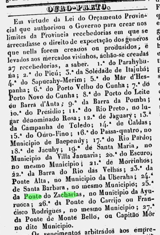
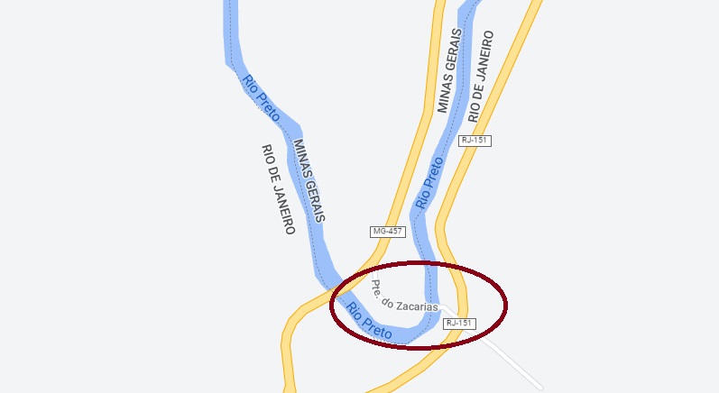
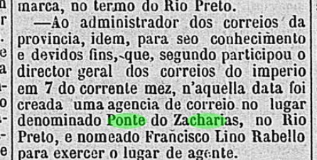
Other names: Porto do Zacharias, Ponte do Zacharias
See also Ponto do Zacharias (R. Koester: Carimbologia XXXII)
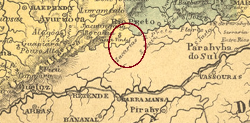
The Zacharias Bridge was built over the Rio Preto, close to the vila of the same name and right on the natural border between the provinces of Minas Gerais and Rio de Janeiro, 340 km south of Ouro Preto. On the Minas Gerais side, a Recebedoria (customs house) was established in July 1839 to collect export tax on goods sold in Rio de Janeiro.
O Universal, 08.07.1839
In October 1861, the province of Rio followed suit and also established a Registro on its side of the river to determine the “origin of imported coffee”.
Diario do Rio de Janeiro, 09.11.1861
In August 1874, a post office was established at the Recebedoria on the Minas Gerais side, as reported by the regional press:
Diario de Minas, 25.11.1874
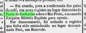
A second post office opening in 1881 is noted in the Directory of Imperial Post Offices (Tabella das Agencias do Correio do Imperio, Rio de Janeiro, 1885) in the “Freguesia” called Ponto do Zacharias. This incorrect designation led R. Koester to assume that this was a railway station post office (Carimbologia XXXII). According to Paulo Novaes (agenciaspostais.com.br), the post office was closed “around 1885”, and there was no railway line over the bridge yet. So far, no imperial postmark has appeared from there. See also (in Portuguese):
Andere Namen: Porto do Zacharias, Ponte do Zacharias
Siehe auch Ponto do Zacharias (R. Koester: Carimbologia XXXII)
Die Zacharias-Brücke wurde über dem Rio Preto gebaut, nah an der gleichnamigen Vila und direkt an der Naturgrenze zwischen den Provinzen Minas Gerais und Rio de Janeiro, 340 km südlich von Ouro Preto entfernt. Auf der Minas Gerais-Seite wurde im Juli 1839 eine Recebedoria (Zollhaus) eingerichtet, um die Ausfuhrsteuer über Waren einzukassieren, die in Rio de Janeiro verkauft wurden.
O Universal, 08.07.1839
Im Oktober 1861 zog die Provinz Rio nach und errichtete auch ein Registro auf ihrer Flussseite, um den „Ursprung des importierten Kaffees“ zu ermitteln.
Diario do Rio de Janeiro, 09.11.1861
Im August 1874 wurde entschieden, an der Recebedoria in Minas ein Postamt zu installieren, wie die Presse aus Minas Gerais berichtet:
Diario de Minas, 25.11.1874
Eine zweite Posteröffnung 1881 wird im Verzeichnis der kaiserlichen Postämter (Tabella das Agencias do Correio do Imperio, Rio de Janeiro, 1885) in der „Freguesia“ namens Ponto do Zacharias festgestellt. Diese falsche Ortsangabe führte R. Koester zur Annahme, es handelte sich hier um einen Bahnhofspostamt (Carimbologia XXXII). Laut Paulo Novaes (agenciaspostais.com.br) wurde das Postamt „ca. 1885“ geschlossen, und da war noch keine Bahnlinie über die Brücke. Bisher ist kein kaiserlicher Poststempel von dort aufgetaucht. Siehe auch (Portugiesisch):
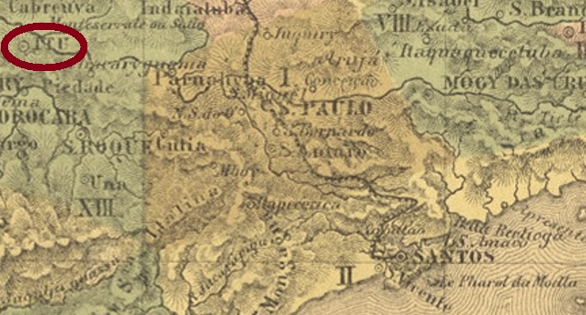
Villiers de l’Ile Adam: Carta (…) da Provincia de São Paulo, 1847
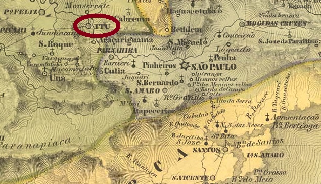
This village, old by Brazilian standards, was the chapel of N. Sra. da Candelária from February 1610 and was located on the south bank of the Tietê, barely 100 km west of the later provincial capital of São Paulo. Ytu became a freguesia in 1653, a vila in April 1657 and a town in February 1842.
Two years of origin for the local post office have been found. First in October 1824, as Nova Monteiro writes in Administrações e Agencias Postaes do Brasil Imperio (Brasil Filatelico/RJ, 1934-5; Reprint SPP 1994-1999). Then in 1844, according to the Directory of Imperial Post Offices (Tabella das Agencias do Correio do Imperio, Rio de Janeiro, 1885).
The first two postmarks have been definitively used in the pre-philatelic period. YSP-1615a was in use at least between 1825 and 1829 and was already made known by the RHM catalogue:
YSP-1615a (RHM P-SP-59)
Parallel to this – more precisely between 1825 and at least 1850 – YSP-1615b was in use, which can not only be seen in the RHM, but was also recorded with no. 1542 in the Catálogo de Carimbos Brasil-Império (S. Paulo, 1937, 1942) by Paulo Ayres:
YSP-1615b (RHM P-SP-60, P.A. 1542)
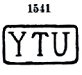
Then there came YSP-1615c, used between about 1843 and at least 1866. This postmark also exists in red; it can be seen in the Paulo Ayres (op. cit.) with no. 1541:
YSP-1615c (P.A. 1541)
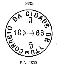
Its successor YSP-1615d came into use from about 1850 – also in red – and is also listed in Paulo Ayres, this time under no. 1635:
YSP-1615d (P.A. 1635)
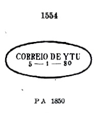
YSP-1615e was also in use at somewhat the same time and can also be seen in P. Ayres:
YSP-1615e (P.A. 1554) 1850ff-1869
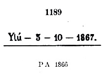
Also YSP-1615f, which also occurs in blue between 1866 and 1881, with P. Ayres no. 1189. However, the dot at the end may sometimes be missing:
YSP-1615f (P.A. 1189)
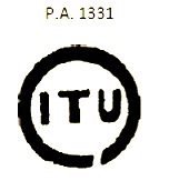
All the following postmarks have ITU written with I. ISP-0660a was in circulation from about 1866 and was given No. 1331 by P. Ayres:
ISP-0660a (P.A. 1331)
ISP-0660b apparently occurred in blue, was in use from ca. 1866 to ca. 1877 and has no. 1332 by P. Ayres:
ISP-0660b (P.A. 1332)
Five more postmarks followed as double circles until the end of the 19th century. The French type ISP-0660c (Coll. José L. Fevereiro) has the inscription ITÚ above and the asterisk between brackets below. Dates in the centre go from 1871 to 1879. ISP-0660d (Coll. Mário Celso Orsi Jr.) also exists in violet and blue, with internal dates from 1881 to 1886. Here the accent on the U is barely visible, if at all. ISP-0660e (Coll. Mário Celso Orsi Jr.) is also found in violet, has ITU written in wide letters at the top and a five-pointed star without brackets at the bottom, with inner dates from 1886 to 1890. On ISP-0660f (image from the internet), the letters of ITU are not quite as wide, and the accent on the U looks more like a dot. A specimen was seen, dated 1887. Finally, ISP-0660g (image by Luís C. Fritzen) is a second French type, but this time the letters of ITU are narrower. A specimen from 1897 was found.
Mário Celso Orsi Jr. also presents a handwritten cancellation from Itu:
1866ff (MO)
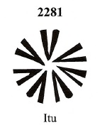
Then we have three mute cancellations from there. The first of these has already been presented by J. Dingler and K. W. Lopes in Mute Cancellations of the Brazil Empire / Carimbos Mudos do Brasil Império (Brazil Philatelic Association, Rio de Janeiro, 2000) under no. 2281:
BPA 2281
The second mute cancel comes from the Fuad Ferreira Fo. collection:
1867 (FF)
Lastly, another mute cancellation, as announced by Mário Celso Orsi Jr:
1872-1881 (MO)Atlas do Imperio do Brasil, 1868
Diese für brasilianische Verhältnisse alte Ortschaft war ab Februar 1610 die Kapelle von N. Sra. da Candelária und lag am Südufer des Tietê, knapp 100 km westlich der späteren Provinzhauptstadt São Paulo entfernt. Ytu wurde 1653 zur Freguesia, im April 1657 zur Vila und im Februar 1842 zur Stadt.
Zwei Entstehungsjahre fürs örtliche Postamt wurden gefunden. Erstmals im Oktober 1824, wie Nova Monteiro in Administrações e Agencias Postaes do Brasil Imperio (Brasil Filatelico/RJ, 1934-5; Reprint SPP 1994-1999) schreibt. Dann 1844, laut demVerzeichnis der kaiserlichen Postämter (Tabella das Agencias do Correio do Imperio, Rio de Janeiro, 1885).
Die ersten beiden Poststempel sind nachweislich in der Vorphila-Zeit verwendet worden. YSP-1615a war zumindest zwischen 1825 und 1829 in Gebrauch und wurde bereits durch den RHM-Katalog bekannt gemacht:
YSP-1615a (RHM P-SP-59)
Parallel dazu – genauer zwischen 1825 bis zumindest 1850 – wurde YSP-1615b verwendet, der nicht nur im RHM zu sehen ist, sondern auch mit Nr. 1542 im Catálogo de Carimbos Brasil-Império (S. Paulo, 1937, 1942) von Paulo Ayres registriert wurde:
YSP-1615b (RHM P-SP-60, P.A. 1542)
Danach kam YSP-1615c, verwendet zwischen ca. 1843 und mindestens 1866. Diesen Poststempel gibt es auch in Rot, er ist im Paulo Ayres (op. cit.) mit Nr. 1541 zu sehen:
YSP-1615c (P.A. 1541)
Sein Nachfolger YSP-1615d kam ab ca. 1850 in Gebrauch – auch in Rot – und ist ebenfalls in Paulo Ayres aufgelistet, diesmal unter Nr. 1635:
YSP-1615d (P.A. 1635)
Auch YSP-1615e wurde etwas zur gleichen Zeit gebraucht und ist auch im P. Ayres zu sehen:
YSP-1615e (P.A. 1554) 1850ff-1869
Ebenfalls YSP-1615f, der auch in Blau zwischen 1866 und 1881 vorkommt, mit P. Ayres Nr. 1189. Allerdings kann der Punkt am Ende manchmal fehlen:
YSP-1615f (P.A. 1189)
Alle folgenden Poststempel haben ITU mit I geschrieben. ISP-0660a war ab ca. 1866 im Umlauf und bekam von P. Ayres die Nr. 1331:
ISP-0660a (P.A. 1331)
ISP-0660b kommt angeblich in Blau vor, wurde von ca. 1866 bis ca. 1877 verwendet und hat Nr. 1332 bei P. Ayres:
ISP-0660b (P.A. 1332)
Es folgten noch fünf Poststempel als Doppelkreise bis Ende des 19. Jahrhunderts. Der Französische Typus ISP-0660c (Samml. José L. Fevereiro) hat oben die Inschrift ITÚ und unten des Sternchen zwischen Klammern. Daten in der Mitte von 1871 bis 1879. ISP-0660d (Samml. Mário Celso Orsi Jr.) gibt es auch in Violett und Blau, mit inneren Daten von 1881 bis 1886. Hier ist der Akzent auf dem U kaum oder nicht zu sehen. ISP-0660e (Samml. Mário Celso Orsi Jr.) kommt auch in Violett vor, hat oben ITU mit breiten Buchstaben geschrieben und unten einen fünfzackigen Stern ohne Klammer, dazu innere Daten von 1886 bis 1890. Bei ISP-0660f (Abb. aus dem Internet) sind die Buchstaben von ITU nicht ganz so breit, und der Akzent auf dem U sieht eher wie ein Punkt aus. Ein Exemplar gesehen, datiert 1887. Schließlich kommt mit ISP-0660g (Abb. Luís C. Fritzen) ein zweiter Französischer Typ dazu, wobei die Buchstaben von ITU diesmal schmäler sind. Ein Exemplar aus 1897.
Mário Celso Orsi Jr. kennt auch eine handschriftliche Entwertung aus Itu:
1866ff (MO)
Dann haben wir noch drei stumme Abstempelungen von dort. Die erste davon wurde bereits durch J. Dingler und K. W. Lopes in Mute Cancellations of the Brazil Empire / Carimbos Mudos do Brasil Império (Brazil Philatelic Association, Rio de Janeiro, 2000) unter Nr. 2281 vorgestellt:
BPA 2281
Die zweite stumme Abstempelung kommt aus der Sammlung Fuad Ferreira Fo.:
1867 (FF)
Zuletzt eine stumme Abstempelung, wie Mário Celso Orsi Jr. bekannt gab: