See also Vila Mariana (R. Koester: Carimbologia XXVII)
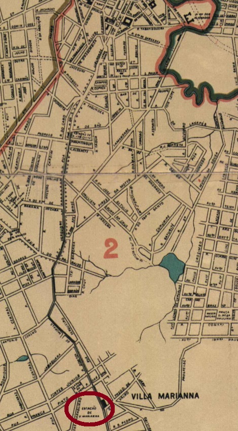
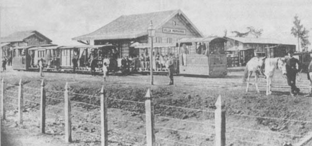
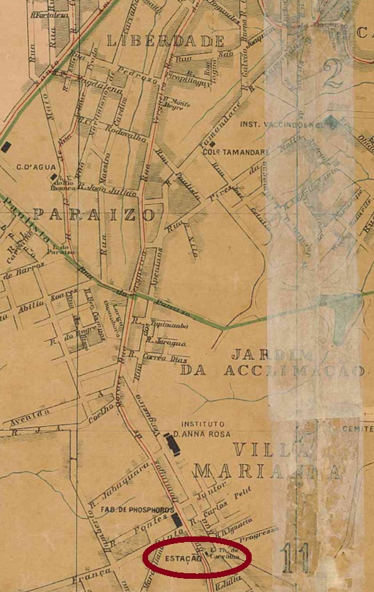
The present-day district of Vila Mariana was formerly a suburb of São Paulo, located about 6 km south of the city centre. A railway station of the Cia. Carris de Ferro de Santo Amaro was inaugurated there in December 1885. In 1900 the railway line passed to the Light and Power Company, but five years later the station was demolished to build tram shunting yards.
ca. 1905 (in estacoesferroviarias.com.br)
The station post office started operations in November 1886, according to the local press:
Correio Paulistano, 13/11/1886
The first postmark is probably VSP-1880a (Coll. José A. Junges): a double circle with the inscription ESTAÇÃO V. MARIANA above and a small ornament in circle below. The dates in the middle have been found so far for the period 1890-1895.
Cidade de São Paulo, 1905
Siehe auch Vila Mariana (R. Koester: Carimbologia XXVII)
Der heutige Stadtteil Vila Mariana war ehemals ein Vorort von São Paulo, der ca. 6 km südlich der Stadtmitte lag. Dort wurde im Dezember 1885 ein Bahnhof der Cia. Carris de Ferro de Santo Amaro eingeweiht. 1900 ging die Bahnlinie zur Light and Power Gesellschaft über, doch fünf Jahre später wurde der Bahnhof abgerissen, um einen Tram-Rangierbahnhof zu bauen.
ca. 1905 (in estacoesferroviarias.com.br)
Der Bahnhofspostamt nahm seinen Betrieb im November 1886 auf, wie die Lokalpresse berichtet:
Correio Paulistano, 13.11.1886
Der erste Poststempel wird wohl VSP-1880a (Samml. José A. Junges) sein: ein Doppelkreis mit der Inschrift ESTAÇÃO V. MARIANA oben und einem kleinen Ornament in Kreis unten. Die Daten in der Mitte wurden bisher für den Zeitraum 1890-1895 gefunden.
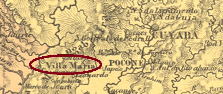
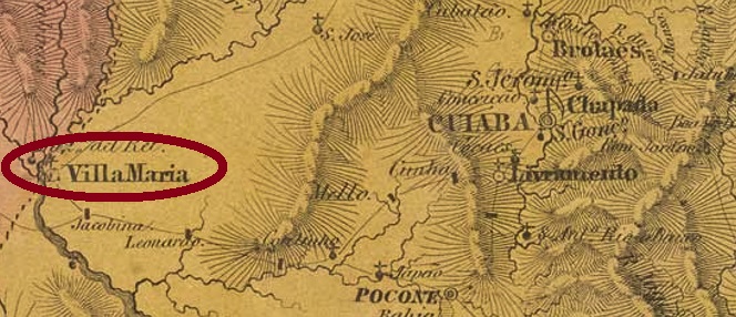
Since the end of the 18th century, this village was the early freguesia of São Luiz de Villa Maria, located on the east bank of the Paraguay River, 220 km west of the later provincial capital Cuiabá (then written Cuyaba). The name is a tribute to Queen Maria I of Portugal. In October 1859, the place emancipated itself as a villa, and in May 1874 it became a town called São Luiz de Caceres, after the former governor Luís de Albuqerque de Mello Pereira e Cáceres (1739-1797). Since 1938, the simplified place name has been Cáceres.
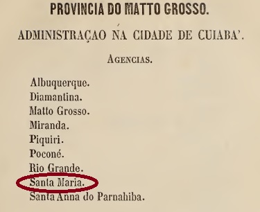
There was a former post office for Villa Maria, which was located on the important postal route between Cuyabá and the old capital Villa Bella do Matto Grosso and was operated with the interruption of the war against Paraguay (1864-1870). The oldest mention is in the Guia do Correio do Brazil of 1856, although under Santa Maria:
Guia do Correio do Brazil, 1856
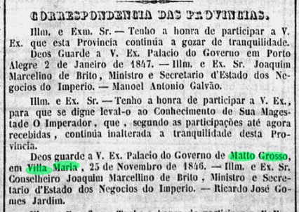
Before that, it is quite possible that a post office was already in operation in Villa Maria, at least temporarily, in the 1840s, because it was mentioned as a provisional provincial capital in the official press from Rio de Janeiro at the end of 1846:
Gazeta Official/RJ, 17.02.1847
The oldest postmark so far is VMT-0115b, used from about 1877 to 1890 and made known by Paulo Ayres in Catálogo de Carimbos Brasil-Império (S. Paulo, 1937, 1942):
VMT-0115b (P.A. p. 126)
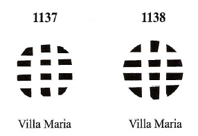
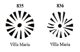
J. Dingler and K.W. Lopes have presented four mute cancellations from Villa Maria in Mute Cancellations of the Brazil Empire / Carimbos Mudos do Brasil Império (Brazil Philatelic Association, Rio de Janeiro, 2000):
BPA 835-836 (P.A. 234) 1883BPA 1137-1138 (1880ff)
For postmarks featuring S. Luiz de Cáceres see SMT-0070.
Villiers de l’Ile Adam: Carta (…) da Provincia do Matto Grosso, 1850
Andere Namen: São Luiz de Cáceres, Cáceres (1938)
Diese Ortschaft war seit dem Ende des 18. Jahrhunderts die frühe Freguesia von São Luiz de Villa Maria, die am Ostufer des Flusses Paraguay lag, 220 km westlich der späteren Provinzhauptstadt Cuiabá (damals Cuyabá geschrieben) entfernt. Der Name ist eine Hommage an die Königin Maria I von Portugal. Im Oktober 1859 emanzipierte sich der Ort als Villa, und im Mai 1874 wurde daraus eine Stadt, die São Luiz de Caceres heißt, nach dem ehemaligen Gouverneur Luís de Albuqerque de Mello Pereira e Cáceres (1739-1797). Seit 1938 gilt der vereinfachte Ortsname Cáceres.
Es gab ein früheres Postamt für Villa Maria, die an der wichtigen Postroute zwischen Cuyabá und der alten Hauptstadt Villa Bella do Matto Grosso lag und – mit der Unterbrechung des Kriegs gegen Paraguay (1864-1870) – wohl ständig betrieben wurde. Die älteste Erwähnung ist im Guia do Correio do Brazil von 1856 zu lesen, allerdings unter Santa Maria:
Guia do Correio do Brazil, 1856
Darüber hinaus ist es gut möglich, dass bereits in den 40er Jahren zumindest vorübergehend ein Postamt in Villa Maria in Betrieb war, denn die Villa wurde Ende 1846 als provisorische Provinzhauptstadt in der Amtspresse aus Rio de Janeiro erwähnt:
Gazeta Official/RJ, 17.02.1847
Der bisher älteste Poststempel ist VMT-0115b, der ab ca. 1877 bis 1890 verwendet und durch Paulo Ayres in Catálogo de Carimbos Brasil-Império (S. Paulo, 1937, 1942) bekannt gemacht wurde:
VMT-0115b (P.A.-S. 126)
J. Dingler und K.W. Lopes haben vier stumme Abstempelungen aus Villa Maria in Mute Cancellations of the Brazil Empire / Carimbos Mudos do Brasil Império (Brazil Philatelic Association, Rio de Janeiro, 2000) präsentiert:
BPA 835-836 (P.A. 234) 1883BPA 1137-1138 (1880ff)
Für Poststempel mit S. Luiz de Cáceres siehe SMT-0070.
Other names: Other names: Brejo do Amparo, Brejo do Salgado, Porto do Salgado
See also Januária (R. Koester: Carimbologia XXV)
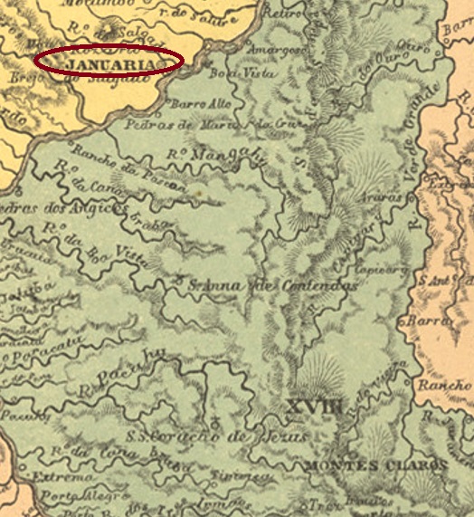
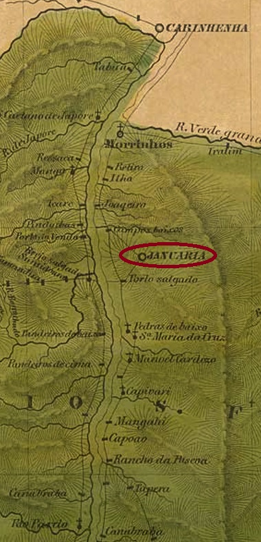
This locality also causes some headaches for researchers, as it has not only been renamed many times, but can also be seen in different places on old maps. What seems certain is that from January 1811 it was the old freguesia of Brejo do Amparo, which belonged to the Vila of Paracatu and was initially located on the right bank of the São Francisco River, about 680 km north of the later provincial capital of Ouro Preto. In June 1833, the place was elevated to a vila, called Villa Januaria de N. Sra. do Amparo do Brejo do Salgado. The Salgado is a tributary of the left bank of the São Francisco, and accordingly the vila was henceforth to be seen on the opposite side of the river. In October 1860, the Vila became a town called Porto do Salgado, but by September 1871, the Município was called Brejo do Amparo, as before. Finally, since September 1884, the municipality has been called Januária, after a daughter of Emperor Pedro I. Presumably, this was the Solomonic solution after a long name dispute between right- and left-bank inhabitants.
At least as far as the origin of the post office is concerned, there is agreement among researchers. Nova Monteiro (Administrações e Agencias Postaes do Brasil Imperio, in Brasil Filatelico/RJ, 1934-5; Reprint SPP 1994-1999), Paula Sobrinho (História Postal de Minas Gerais, Belo Horizonte, 1997) and Reinhold Koester (Carimbologia XXV) unanimously name October 1833. The oldest postmark is VMG-1416a; it also occurs in sepia with dates of use from 1836 to 1847 and has already been presented in the RHM catalogue under P-MG-32:
VMG-1416a (RHM P-MG-32)
Later postmarks bear the inscription JANUARIA and have already been shown by R. Koester (op. cit.).
Villiers de l’Ile Adam: Carta (…) da Provincia de Minas Geraes, 1849
Andere Namen: Brejo do Amparo, Brejo do Salgado, Porto do Salgado
Siehe auch Januária (R. Koester: Carimbologia XXV)
Auch diese Ortschaft bringt einige Kopfzerbrechen für die Forscher, da sie nicht nur oft umbenannt wurde, sondern auch an verschiedenen Stellen auf alten Karten zu sehen ist. Sicher scheint es zu sein, sie war ab Januar 1811 die alte Freguesia von Brejo do Amparo, die der Vila von Paracatu gehörte und zunächst am rechten Ufer des Flusses São Francisco lag, etwa 680 km nördlich der späteren Provinzhauptstadt Ouro Preto entfernt. Im Juni 1833 wurde der Ort zu einer Vila erhoben, die Villa Januaria de N. Sra. do Amparo do Brejo do Salgado hieß. Nun ist der Salgado ein Nebenfluss des linken Ufers vom São Francisco, und dementsprechend war die Vila fortan auf der gegenüberliegenden Flussseite zu sehen. Im Oktober 1860 wurde aus der Vila eine Stadt mit Namen Porto do Salgado, aber schon im September 1871 hieß der Município Brejo do Amparo, wie früher. Schließlich seit September 1884 heißt die Gemeinde Januária, nach einer Tochter des Kaisers Pedro I. Vermutlich war das die salomonische Lösung nach einem langen Namensstreit zwischen Rechts- und Linksufereinwohnern.
Zumindest was die Entstehung des Postamts betrifft, herrscht Einigkeit unter den Forschern. Nova Monteiro (Administrações e Agencias Postaes do Brasil Imperio, in Brasil Filatelico/RJ, 1934-5; Reprint SPP 1994-1999), Paula Sobrinho (História Postal de Minas Gerais, Belo Horizonte, 1997) und Reinhold Koester (Carimbologia XXV) nennen dafür einstimmig den Oktober 1833. Der älteste Poststempel ist VMG-1416a; er kommt auch in sepia mit Verwendungsdaten von 1836 bis 1847 vor und wurde bereits im RHM-Katalog unter P-MG-32 vorgestellt:
VMG-1416a (RHM P-MG-32)
Spätere Poststempel tragen die Inschrift JANUARIA und wurden bereits von R. Koester (op. cit.) gezeigt.
Carta Corographica da Provincia de Pernambuco, 1880
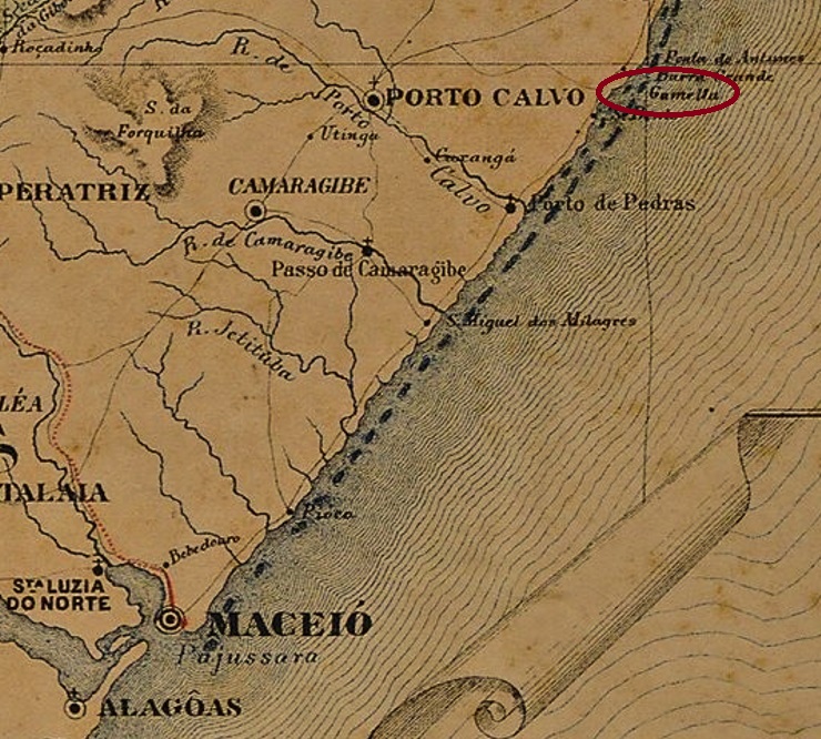
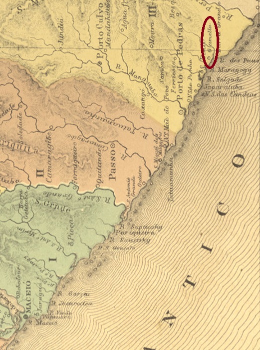
Other names: Gamella, Maragogy (1876)
See also Gamella (R. Koester: Carimbologia XX)
The old settlement of Gamella (= trough) grew near the vila of Porto Calvo and was situated on the north bank of the Maragogi River, 130 km northeast of the provincial capital Maceió. In April 1875, the village rose to become a vila, probably named after Princess Isabel. However, the place name changed again in July 1876 to Maragogy. Since May 1892, Maragogi (as it is written today) has been a town.
Three years of origin for the local post office have been found, of which Nova Monteiro’s indication of 1865 in Administrações e Agencias Postaes do Brasil Imperio (Brasil Filatelico/RJ, 1934-5; Reprint SPP 1994-1999) is said to be a transcription error, as R. Koester claims in Carimbologia XX. He pleads for December 1855. The third date would be February 1876, as Aldo Cardoso writes in Contribuição para a História dos Correios de Alagoas (Maceió, 1969). So far, no postmark has been seen under Gamella or Villa Izabel, Koester shows in Carimbologia XX a cancellation under Maragogy from 1885.
Atlas do Imperio do Brasil, 1868
Andere Namen: Gamella, Maragogy (1876)
Siehe auch Gamella (R. Koester: Carimbologia XX)
Die alte Siedlung von Gamella (= Trog) wuchs bei der Vila von Porto Calvo und lag am Nordufer des Maragogi-Flusses, 130 km nordöstlich der Provinzhauptstadt Maceió entfernt. Im April 1875 stieg der Ort zur Vila auf, die wohl nach der Prinzessin Isabel genannt wurde. Allerdings wechselte der Ortsname abermals im Juli 1876 zu Maragogy. Seit Mai 1892 ist Maragogi (wie es heute geschrieben wird) eine Stadt.
Drei Entstehungsjahre fürs örtliche Postamt wurden gefunden, davon soll Nova Monteiros Angabe über 1865 in Administrações e Agencias Postaes do Brasil Imperio (Brasil Filatelico/RJ, 1934-5; Reprint SPP 1994-1999) ein Abschreibfehler sein, wie R. Koester in Carimbologia XX behauptet. Er plädiert für den Dezember 1855. Der dritte Termin wäre der Februar 1876, wie Aldo Cardoso in Contribuição para a História dos Correios de Alagoas (Maceió, 1969) schreibt. Bisher war kein Poststempel unter Gamella oder Villa Izabel zu sehen, Koester zeigt in Carimbologia XX eine Entwertung unter Maragogy aus 1885.
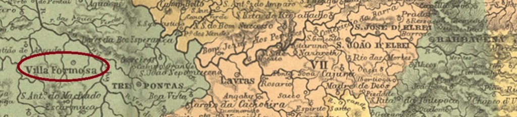
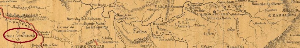
See also Alfenas and Formosa de Alfenas (R. Koester: Carimbologia I and XIX)
The freguesia of São José de Alfenas was established in July 1832 in the município of Caldas and was situated between the São Tomé and Sapucaí rivers, about 390 km southwest of the provincial capital Ouro Preto. In October 1860, it was promoted to Villa Formosa de Alfenas, and exactly nine years later it became a town whose name was shortened to Alfenas in September 1871. Reinhard Koester (Carimbologia XIX) states that this name change was to avoid confusion with the older Villa Formosa (da Imperatriz) in Goiás.
Three dates have been established for the birth of the post office from 1862. Nova Monteiro, in Administrações e Agencias Postaes do Brasil Imperio (Brasil Filatelico/RJ, 1934-5; Reprint SPP 1994-1999) writes the month of March for it, while Paula Sobrinho (História Postal de Minas Gerais, Belo Horizonte, 1997) and Koester (op.cit.) prefer June. The third date is in April 1862 as reported by the Rio press:
Jornal do Commercio/RJ, 25.04.1862, exped. 09.04.
Consequently, Nova Monteiro’s indication could be a transcription error, whereas the date mentioned by Paula Sobrinho and Koester would be the start of operation of the agency. So far, no postmark with Villa Formosa (or de Alfenas) has appeared. Koester (op.cit.) lists postmarks with Alfenas from 1880 on.
Provincia de Minas Geraes, 1873
Siehe auch Alfenas und Formosa de Alfenas (R. Koester: Carimbologia I und XIX)
Die Freguesia von São José de Alfenas wurde im Juli 1832 im Município von Caldas errichtet und lag zwischen den Flüssen São Tomé und Sapucaí, ca. 390 km südwestlich der Provinzhauptstadt Ouro Preto entfernt. Im Oktober 1860 erfolgte der Aufstieg zur Villa Formosa de Alfenas, und genau neun Jahre später wurde daraus eine Stadt, deren Name im September 1871 zu Alfenas verkürzt wurde. Reinhard Koester (Carimbologia XIX) meint, diese Namensänderung sollte Verwechslungen mit der älteren Villa Formosa (da Imperatriz) in Goiás vermeiden.
Aus dem Jahr 1862 wurden drei Daten für die Entstehung des Postamtes ermittelt. Nova Monteiro schreibt dafür im Administrações e Agencias Postaes do Brasil Imperio (Brasil Filatelico/RJ, 1934-5; Reprint SPP 1994-1999) den Monat März, während Paula Sobrinho (História Postal de Minas Gerais, Belo Horizonte, 1997) und Koester (op.cit.) den Juni bevorzugen. Der dritte Zeitpunkt liegt im April 1862 und wurde in der Presse aus Rio bekannt gemacht:
Jornal do Commercio/RJ, 25.04.1862, exped. 09.04.
Folglich könnte Nova Monteiros Angabe ein Abschreibfehler sein, während das durch Paula Sobrinho und Koester erwähnte Datum den Betriebsbeginn der Agentur wäre. Bisher ist kein Poststempel mit Villa Formosa (bzw. de Alfenas) erschienen. Koester (op.cit.) listet Poststempel mit Alfenas ab 1880.
Villiers de l’Ile Adam: Carta (:::) das Provincias do Rio Grande do Norte e Parahiba, 1848
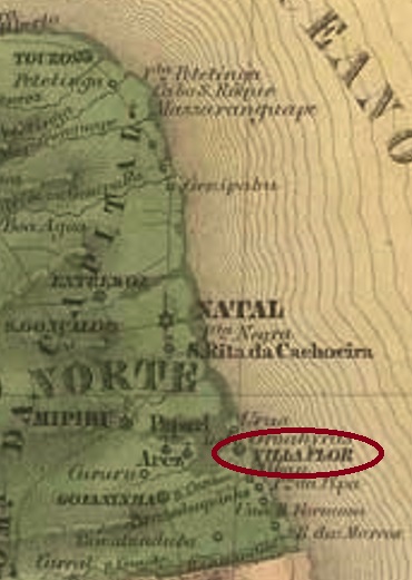
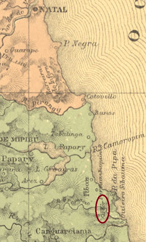
Other names: Gramació, Flor
See also Flor (R. Koester: Carimbologia XIX)
This village was originally an Indian settlement called Gramació, situated on the north bank of the Curimataú River, more than 80 km south of the future provincial capital Natal. In May 1755, the village rose to the status of a vila, but three years later it was moved to the neighbouring village of Canguaretama. In November 1892, Villa Flor became a district of Canguaretama and only regained political independence as a município in December 1963.
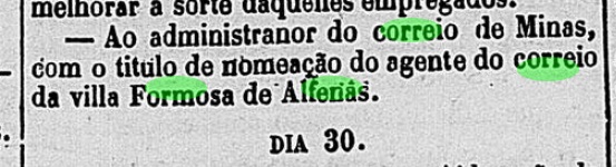
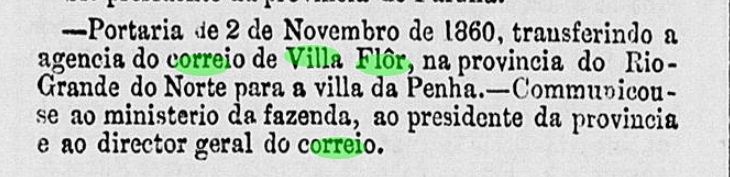
As Nova Monteiro writes in Administrações e Agencias Postaes do Brasil Imperio (Brasil Filatelico/RJ, 1934-5; Reprint SPP 1994-1999), there was a post office there as early as April 1818. With the move to Penha de Canguaretama (1858), the postal agency also moved there two years later, according to the capital’s official press:
Expediente do Ministerio do Imperio, 02.11.1860
Unfortunately, no 19th century postmark from this locality has been seen so far.
Atlas do Imperio do Brasil, 1868
Andere Namen: Gramació, Flor
Siehe auch Flor (R. Koester: Carimbologia XIX)
Diese Ortschaft war ursprünglich eine Indianersiedlung namens Gramació, die am Nordufer des Flusses Curimataú lag, über 80 km südlich der künftigen Provinzhauptstadt Natal entfernt. Im Mai 1755 stieg der Ort zur Vila auf, die aber drei Jahre später zum Nachbarort Canguaretama verlegt wurde. Im November 1892 wurde Villa Flor ein Distrikt von Canguaretama und erhielt erst im Dezember 1963 die politische Selbständigkeit als Município wieder.
Wie Nova Monteiro in Administrações e Agencias Postaes do Brasil Imperio (Brasil Filatelico/RJ, 1934-5; Reprint SPP 1994-1999) schreibt, gab es dort ein Postamt bereits ab April 1818. Mit dem Umzug nach Penha de Canguaretama (1858) zog die Postagentur zwei Jahre später auch dorthin, wie die Amtspresse der Hauptstadt berichtet:
Expediente do Ministerio do Imperio, 02.11.1860
Leider wurde bisher kein Poststempel des 19. Jahrhunderts aus dieser Ortschaft gesehen.
Villiers de l’Ile Adam: Carta (…) da Provincia de Minas Geraes, 1849
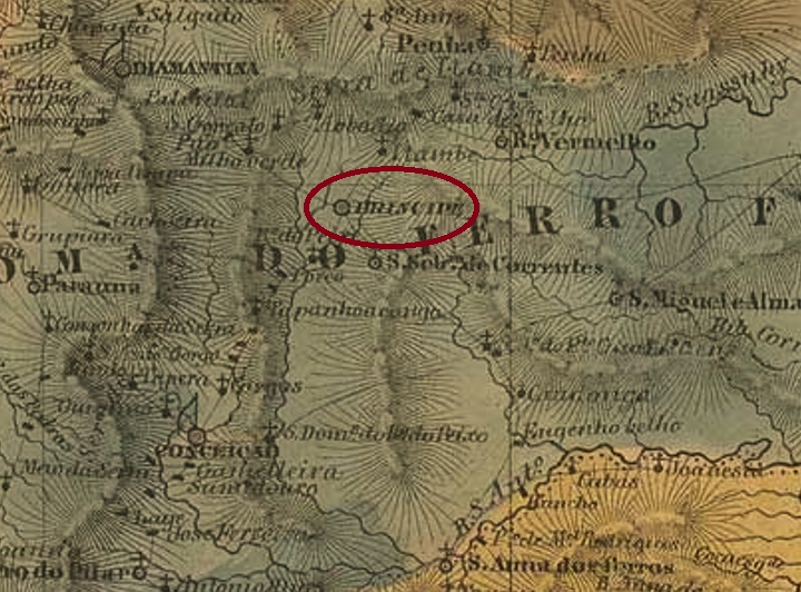
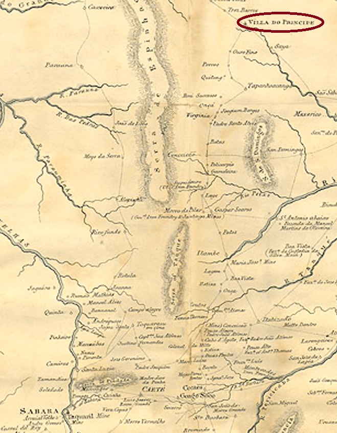
Other names: Grande Serro do Frio, Arraial das Lavras Velhas do Ivituruhy, Cidade do Serro See also Serro (SMG-3100)
This very old settlement was already the Villa do Principe in January 1714, located in the north of the Capitania of Minas Gerais, 330 km north of the future provincial capital Ouro Preto. In March 1838, the place rose to become a town, and is today a tourist magnet as a historical site.
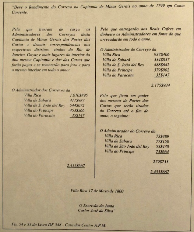
Paula Sobrinho writes in História Postal de Minas Gerais (Belo Horizonte, 1997) that there was a post office there from March 1798. This can be confirmed by a document discovered and published by the Portuguese philatelist Luís Brito Frazão, the balance sheet figures of the five post offices in Minas Gerais for the fiscal year 1799:
Jornal de Filatelia No. 64, Oporto, January 2001
Later post office openings are said to have taken place in 1829 and 1836, as recorded in the Directory of Imperial Post Offices (Tabella das Agencias do Correio do Imperio, Rio de Janeiro, 1885) and in the Catálogo Enciclopédico RHM (São Paulo, 1999) respectively. The oldest postmark is probably VMG-3820a, which was already presented in the RHM catalogue under P-MG-51 and was in use before 1840:
VMG-3820a (RHM P-MG-51)
Later postmarks bear the place name Serro and can be found under SMG-3100.
Province of Minas Geraes, 1835
Andere Namen: Grande Serro do Frio, Arraial das Lavras Velhas do Ivituruhy, Cidade do Serro Siehe auch Serro (SMG-3100)
Diese sehr alte Siedlung war bereits im Januar 1714 die Villa do Principe und lag im Norden der Capitania von Minas Gerais, 330 km nördlich der künftigen Provinzhauptstadt Ouro Preto entfernt. Im März 1838 stieg der Ort zur Stadt auf und ist bis heute als historische Stätte ein Touristenmagnet.
Paula Sobrinho schreibt in História Postal de Minas Gerais (Belo Horizonte, 1997) dass es dort ab März 1798 ein Postamt gab. Das kann durch ein Dokument bestätigt werden, das vom portugiesischen Philatelisten Luís Brito Frazão entdeckt und veröffentlicht wurde, die Bilanzzahlen der fünf Postämter in Minas Gerais fürs Geschäftsjahr 1799:
Jornal de Filatelia Nr. 64, Porto, Januar 2001
Spätere Postamteröffnungen sollen 1829 und 1836 stattgefunden haben, wie im Verzeichnis der kaiserlichen Postämter (Tabella das Agencias do Correio do Imperio, Rio de Janeiro, 1885) bzw. im Catálogo Enciclopédico RHM (São Paulo, 1999) registriert wurde. Der älteste Poststempel ist wohl VMG-3820a, der bereits im RHM Katalog unter P-MG-51 vorgestellt wurde und vor 1840 Verwendung fand:
VMG-3820a (RHM P-MG-51)
Spätere Poststempel tragen die Ortsbezeichnung Serro und sind unter SMG-3100 zu finden.
See also: Presídio (Koester: Carimbologia XXXII), Rio Branco (RMG-2110)
Other names: Presídio, Presídio de Ubá, São João Baptista do Presídio, Rio Branco, Visconde do Rio Branco
The long rivalry between the neighbour towns of Visconde do Rio Branco and Ubá in southeast of Minas Gerais has historical roots. The former was originally a district of the municipality of Pomba in 1810, with the sonorous name Distrito de São João Baptista dos Índios Coropós. Eventually after that, the locality became an open prison, surrounded by woods and called S. João Baptista do Presídio, which was made a Villa in February or March 1839. Sometime later there must have been an economic decay, for in 1853 it was degraded to a district of the municipality of Ubá and therefore called Presídio de Ubá (= Ubá Prison). It recovered the old name and Villa status only in 1881, and in the following year was elevated to a town named Visconde do Rio Branco. Such measures show understandingly a wish to leave behind both names of prison and Ubá, even though José Maria da Silva Paranhos, the Viscount of Rio Branco (1819-1880), father of the famous Baron of Rio Branco, probably never visited Minas Gerais.
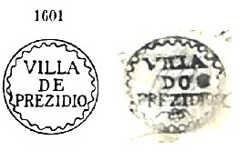
According to Nova Monteiro (Administrações e Agências Postaes do Brasil-Império 1798-1869), a post office was created in December 1839, but seems to have been closed by 1856, for it is absent in Guia do Correio do Brazil of 1857. A famous postal cancel from this early period was used on Bull’s Eyes and already presented by Paulo Ayres (1937) under #1601.
However, Ayres’ image differs considerably from the original, which is presented here through a letter of 1843 from the José L. Fevereiro collection:
VMG-3790a (P. A.1601-recte JLF) 1839-1843ff
Apparently, the post office reopened only in September 1870 (Paula Sobrinho: História Postal de Minas Gerais, Belo Horizonte, 1997). The postmarks from this period were already shown by R. Koester under Presídio (Carimbologia XXXII). Postmarks featuring Rio Branco appeared by 1882 an can be seen under RMG-2110.
Villiers de l’Ile Adam: Carta (…) da Provincia de Minas Geraes, 1849
Siehe auch: Presídio (Koester, Carimbologia XXXII), Rio Branco (RMG-2110)
Andere Namen: Presídio, Presídio de Ubá, São João Baptista do Presídio, Rio Branco, Visconde do Rio Branco
Die lange Rivalität zwischen den Nachbarstädtchen Visconde do Rio Branco und Ubá im Südosten von Minas Gerais hat eine ebenso lange Vorgeschichte. Erstes war ursprünglich (ab 1810) ein Distrikt im Município von Pomba, mit dem wohlklingenden Namen Distrito de São João Baptista dos Índios Coropós. Irgendwann danach wurde aus der Ortschaft ein offenes Gefängnis mitten im Urwald, das sich S. João Baptista do Presídio nannte, das im Februar oder März 1839 als Villa aufgewertet wurde. Aber später soll es wirtschaftlich so weit bergab gegangen sein, dass die Villa in 1853 zum Distrikt vom Nachbar Ubá degradiert wurde, unter dem – zugegeben nicht sehr schmeichelhaften – Namen Presídio de Ubá (= Ubás Gefängnis). Der Status einer Villa mit eigener Verwaltungsautonomie wurde erst in 1881 wieder erlangt, und ein Jahr später war der Ort zur Stadt Visconde do Rio Branco umbenannt. Die letzten Verwaltungsakte zeigen unmissverständlich den Wunsch, die Bezeichnungen Presídio und Ubá loszuwerden, auch wenn José Maria das Silva Paranhos (1819-1880), der Vicomte von Rio Branco und Vater des berühmten Baron von Rio Branco, womöglich niemals in Minas Gerais unterwegs war.
Laut Nova Monteiro (Administrações e Agências Postaes do Brasil-Império 1798-1869) wurde ein Postamt bereits im Dezember 1839 errichtet, das gleichwohl schon vor 1856 wieder geschlossen war, da es nicht im Guia do Correio do Brazil von 1857 aufgelistet wurde. Von dieser Frühzeit ist ein einziger Stempel überliefert, der auf Ochsenaugen zu finden ist und von Paulo Ayres (1937) unter Nr. 1601 registriert wurde. Dennoch zeigt die Ayres’ Abbildung erhebliche Abweichungen, wenn man sie mit dem Originalbild vergleicht, hier in einem Brief vom Jahr 1843 aus der Sammlung José L. Fevereiro:
VMG-3790a (P. A.1601-recte JLF) 1839-1843ff
Das Postamt wurde wohl erst im September 1870 (Paula Sobrinho: História Postal de Minas Gerais, Belo Horizonte, 1997) wieder eröffnet. Die Stempel aus dieser Zeit wurden bereits von R. Koester unter Presídio (Carimbologia XXXII) vorgestellt. Poststempel mit Rio Branco kamen erst um ca. 1882 und können unter RMG-2110 gesehen werden.
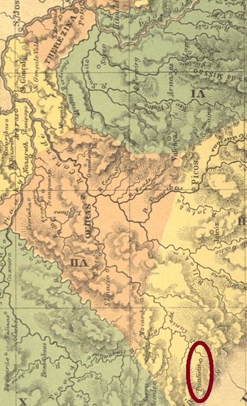
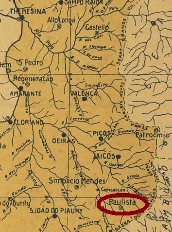
According to a legend, this villa was so named because it originated around 1663 from a large estate founded by the bandeirante Domingos Jorge Velho (1641-1705) from São Paulo, 460 km southeast of the later provincial capital of Teresina. In July 1883, the village was elevated to the district of Jaicós, and two years later Paulista was a villa. In June 1931 it was downgraded as a district of Jaicós, and in September 1933 it was elevated again to a município, which has been called Paulistana since December 1943.
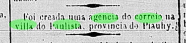
As Reinhold Koester writes in Carimbologia XXX, there had been a post office there since May 1887, which is confirmed by the Rio press:
Gazeta da Tarde/RJ, 31.05.1887
However, the agency is said to have started operations only the following year. So far, no imperial postmark has been seen from this place.
Arthur D. Ribeiro: Estado do Piauhy, 1924
Anderer Name: Paulistana (1943)
Siehe auch Paulista (R. Koester: Carimbologia XXX)
Einer Legende nach hieß diese Villa so, weil sie um 1663 aus einem durch den Bandeirante Domingos Jorge Velho (1641-1705) aus São Paulo gegründeten Großgrundbesitz entstanden ist, der 460 km südöstlich der späteren Provinzhauptstadt Teresina entfernt lag. Im Juli 1883 wurde der Ort zum Distrikt von Jaicós erhoben, zwei Jahre später war Paulista eine Villa. Im Juni 1931 folgte die Herabstufung als Distrikt von Jaicós, und im September 1933 der Wiederaufstieg zu einem Município, der seit Dezember 1943 Paulistana heißt.
Wie Reinhold Koester in Carimbologia XXX schreibt, gab es dort ein Postamt seit Mai 1887, was durch die Presse aus Rio bestätigt wird:
Gazeta da Tarde/RJ, 31.05.1887
Allerdings soll die Agentur den Betrieb erst im folgenden Jahr aufgenommen haben. Bisher war kein kaiserlicher Poststempel aus diesem Ort zu sehen.
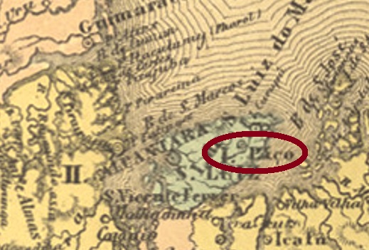
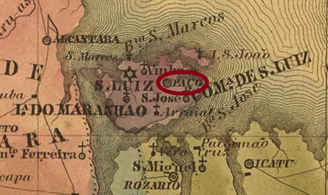
See also Paço do Lumiar (R. Koester: Carimbologia XXIX)
The freguesia of Paço do Lumiar originated as early as June 1757 and belonged to the vila of São Luiz do Maranhão, 13 km away. The village is said to have been promoted to vila twice, in June 1761 and in April 1835. It was not until the 20th century, in February 1931, that it was relegated as a district of São Luís, then 12 years later it changed to the município of Ribamar. Since December 1959, it has been the município of Paço do Lumiar.
As can be read in the postal report (Relatorio Postal) from 1886, there was a post office there since February 1875. So far, no imperial postmark has been found from this locality.
Villiers de l’Ile Adam: Carta (…) da Provincia do Meranhão, 1850
Siehe auch Paço do Lumiar (R. Koester: Carimbologia XXIX)
Die Freguesia von Paço do Lumiar entstand bereits im Juni 1757 und gehörte der 13 km weit entfernte Vila von São Luiz do Maranhão. Der Ort soll zweimal zur Vila aufgestiegen sein, im Juni 1761 und im April 1835. Erst im 20. Jahrhundert, im Februar 1931, erfolgte der Abstieg als Distrikt von São Luís, dann 12 Jahre später wechselte der Ort zum Município von Ribamar. Seit Dezember 1959 ist es der Município von Paço do Lumiar.
Wie im Postbericht (Relatorio Postal) aus 1886 zu lesen ist, gab es dort ein Postamt seit Februar 1875. Bisher wurde kein Poststempel aus der Kaiserzeit aus dieser Gemeinde gefunden.