Categories
Carimbologia Q-R

Piranga, Minas Gerais (PMG-1955)

Atlas do Imperio do Brasil, 1868

Other names: Guará-Piranga

See also Pyranga (train station, PMG-1956)

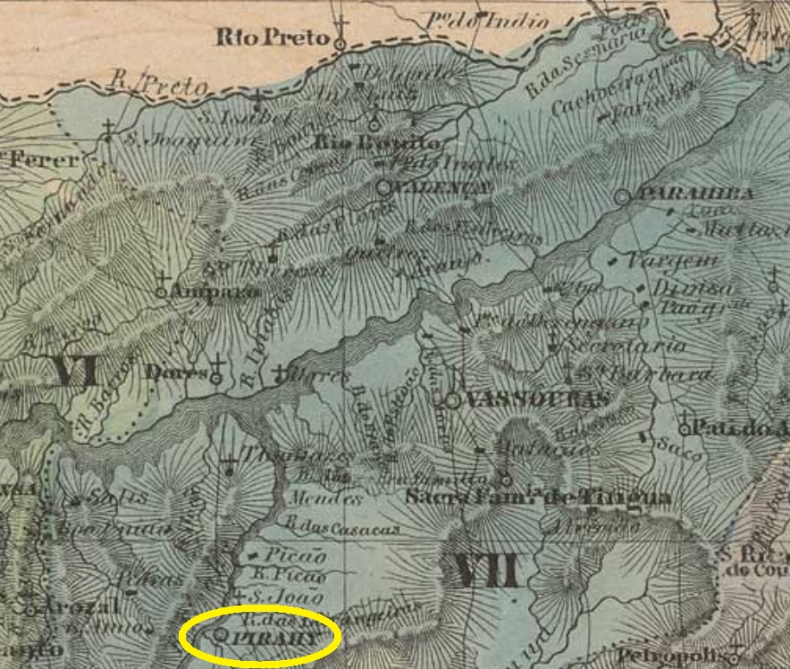
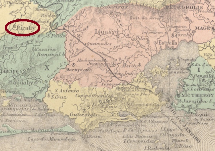
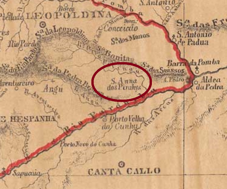
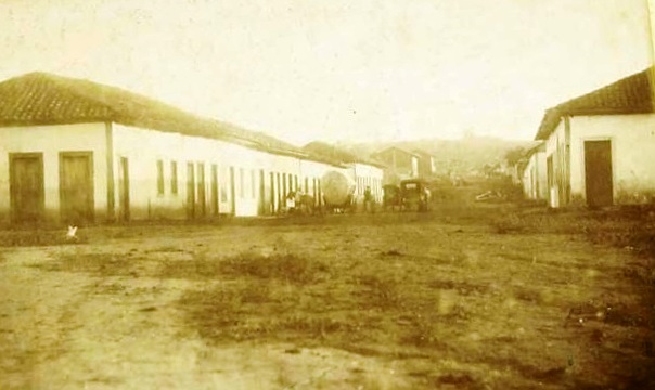
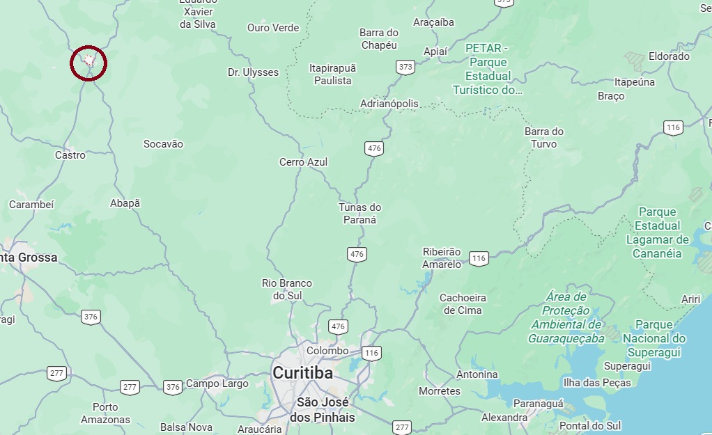
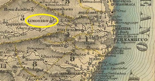
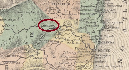
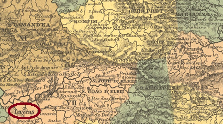
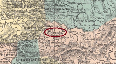
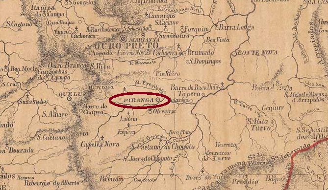
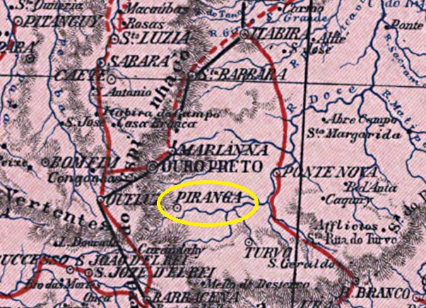
The parish of Nossa Senhora da Conceição de Guará-Piranga was established in February 1724. It belonged to the Vila de Mariana and was situated on the north bank of the Piranga, 70 km south-east of the provincial capital, Ouro Preto. In April 1841, it was elevated to the status of a Vila, which became the town of Piranga in October 1870. The word, derived from Tupi-Guarani, means ‘red clay’.

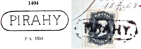
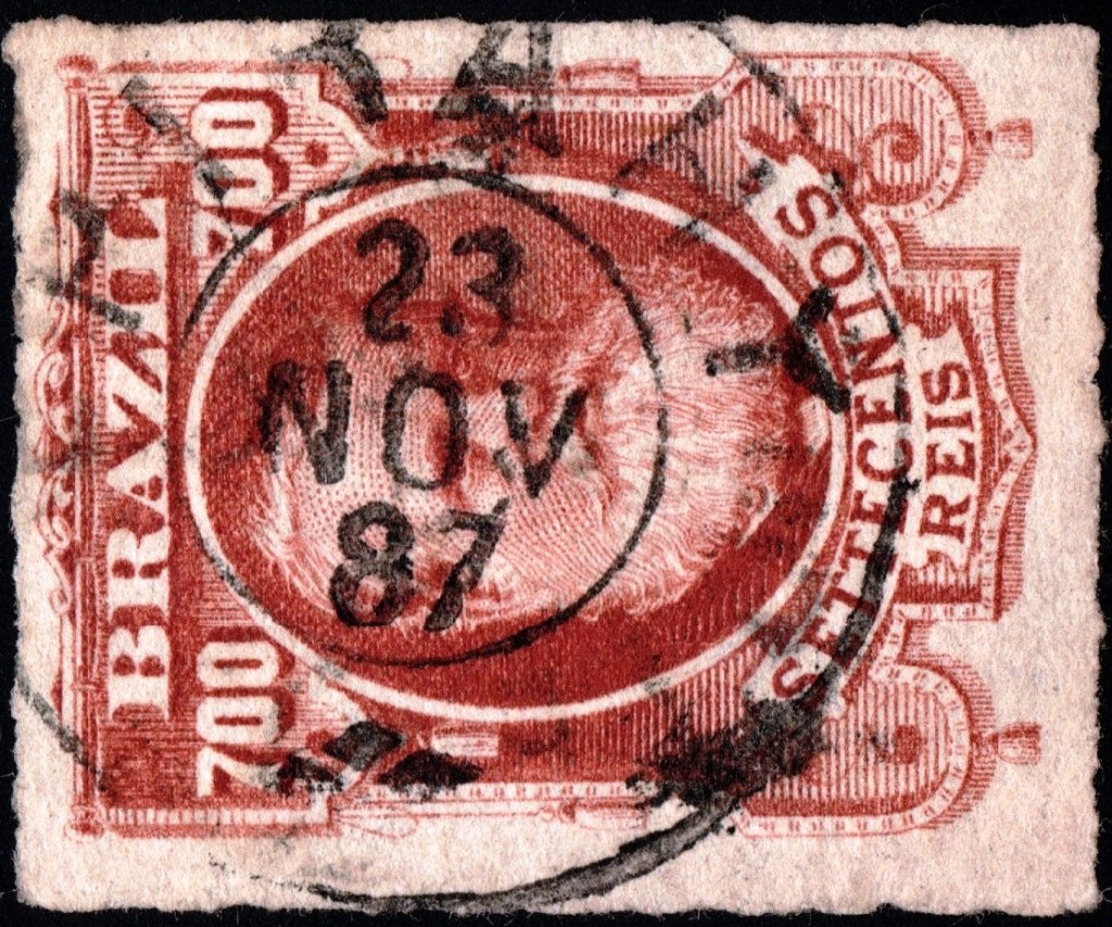
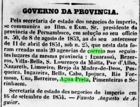
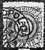
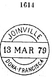
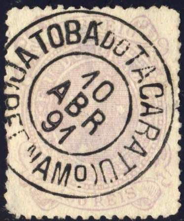
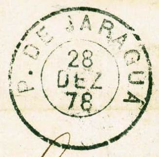
As indicated in the Postal Report (Relatório Postal) for the year 1886, there had been a post office there since February 1843. The oldest postmark to date is PMG-1955a, which is listed in the RHM catalogue under P-MG-45:

PMG-1955a (RHM P-MG-45) 1843ff–1845

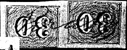
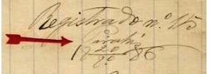
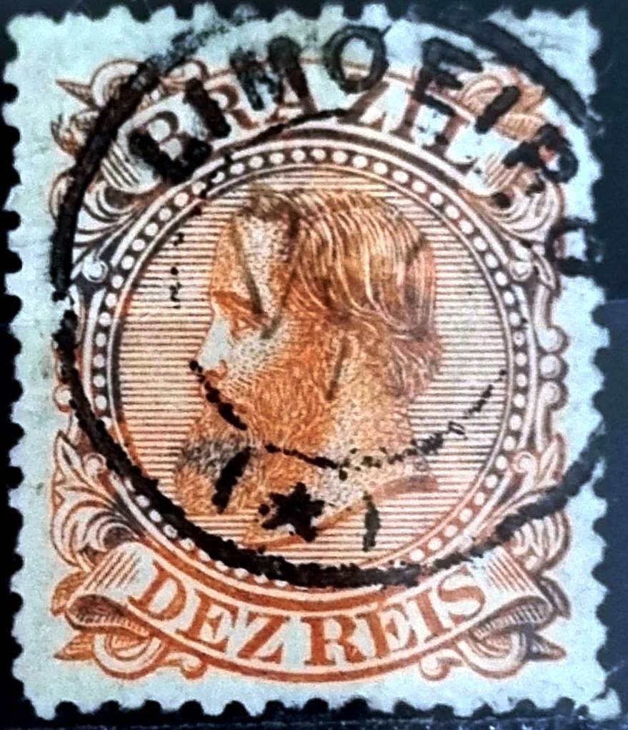
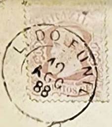
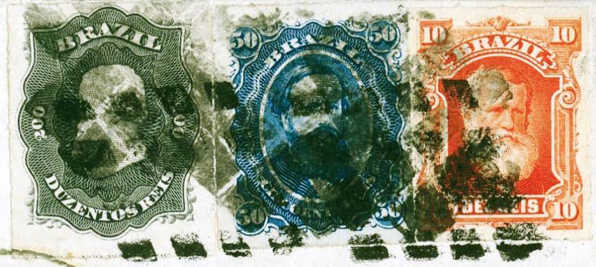
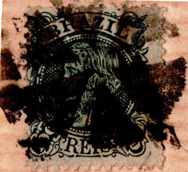
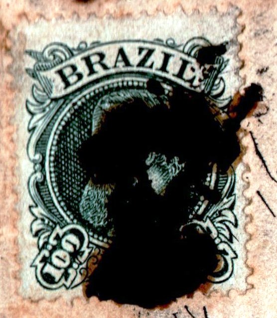
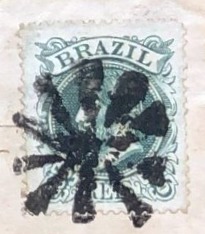
As the following postmark did not appear until much later, stamps were cancelled by hand for a long time, as shown by the example from the Fuad Ferreira Fo. collection:

1850ff (FF)

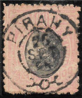
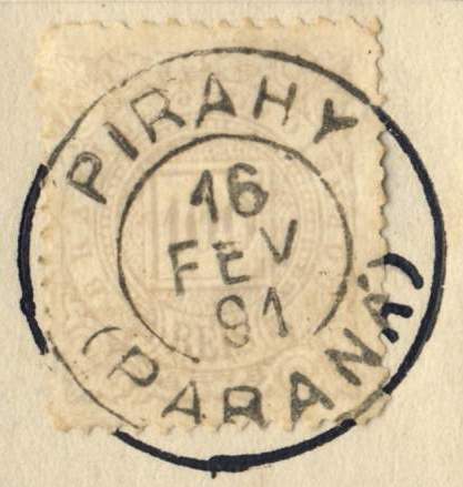
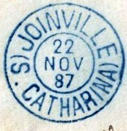
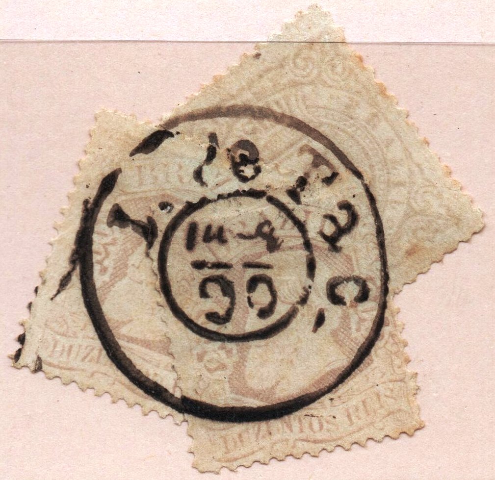
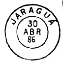
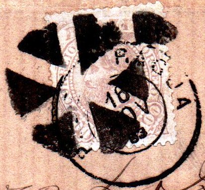
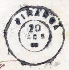
Then came the double-circle PMG-1955b (Fig. Felipe Piccinini):

PMG-1955b (FP) 1880–1889

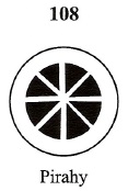
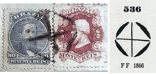
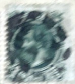
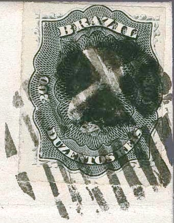
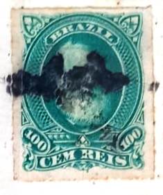
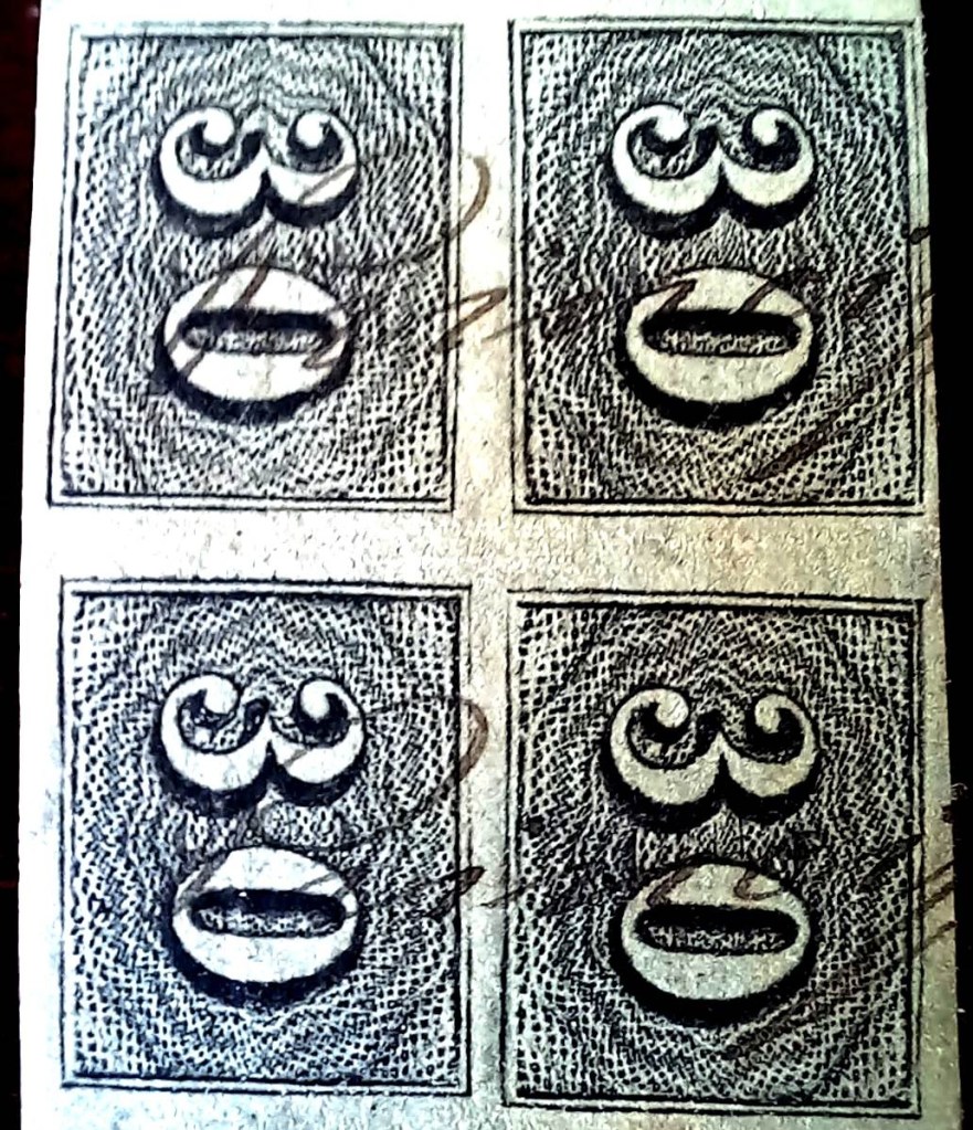
Three mute postmarks from the Empire are known to date from Piranga, here on images by José A. Junges, Fuad Ferreira Fo. and Felipe Piccinini:

1882ff (JJ)
1883 (FF)
1883 (FP)
Provincia de Minas Geraes, 1873

Outros nomes: Guará-Piranga

Veja também Pyranga (Estação, PMG-1956)

A Freguesia de N. Sra. da Conceição de Guará-Piranga existia desde fevereiro de 1724. Pertencia à Vila de Mariana e ficava na margem norte do rio Piranga, 70 km a sudeste da capital provincial, Ouro Preto. Em abril de 1841, foi elevada à categoria de vila, que em outubro de 1870 se tornou a cidade de Piranga. A palavra, de origem tupi-guarani, significa “argila vermelha”.

Conforme consta do Relatório Postal de 1886, havia ali uma agência dos correios desde fevereiro de 1843. O carimbo postal mais antigo encontrado até o momento é o PMG-1955a, registrado no catálogo RHM sob P-MG-45:

PMG-1955a (RHM P-MG-45) 1843ff-1845

Como o carimbo postal a seguir só surgiu muito mais tarde, os selos foram por muito tempo obliterados à mão, como mostra o exemplo da coleção de Fuad Ferreira Fo.:

1850ff (FF)

Em seguida, surgiu o carimbo de duplo círculo PMG-1955b (Ilustração: Felipe Piccinini):

PMG-1955b (FP) 1880-1889

De Piranga, conhecem-se até agora três carimbos mudos do Império, aqui em imagens de José A. Junges, Fuad Ferreira Fo. e Felipe Piccinini:

1882ff (JJ)
1883 (FF)
1883 (FP)
Carta da Republica dos Estados Unidos do Brazil, 1892

Andere Namen: Guará-Piranga

Siehe auch Pyranga (train station/Estação/Bahnhof, PMG-1956)

Die Freguesia de N. Sra. da Conceição de Guará-Piranga bestand seit Februar 1724. Sie gehörte zur Vila de Mariana und lag am Nordufer des Piranga, 70 km südöstlich der Provinzhauptstadt Ouro Preto. Im April 1841 stieg sie zur Vila auf, die im Oktober 1870 die Stadt Piranga wurde. Das Wort aus dem Tupi-guarani bedeutet „roter Lehm“.

Wie aus dem Postbericht (Relatorio Postal) für das Jahr 1886 hervorgeht, gab es dort ein Postamt seit Februar 1843. Der bisher älteste Poststempel ist PMG-1955a, der im RHM-Katalog unter P-MG-45 erfasst wurde:

PMG-1955a (RHM P-MG-45) 1843ff-1845

Da der folgende Poststempel erst viel später erschien, wurden die Briefmarken lange per Hand entwertet, wie das Beispiel aus der Sammlung Fuad Ferreira Fo. zeigt:

1850ff (FF)

Dann kam der Doppelkreis PMG-1955b (Abb. Felipe Piccinini):

PMG-1955b (FP) 1880-1889

Aus Piranga sind bisher drei stumme Stempel aus dem Kaiserreich bekannt, nach Vorlagen von José A. Junges, Fuad Ferreira Fo. und Felipe Piccinini:

1882ff (JJ)
1883 (FF)
1883 (FP)
Categories
Carimbologia Q-R

Pirahy, Rio de Janeiro (PRJ-0785)

Villiers de l’Ile Adam: Carta (…) da Provicnia do Rio de Janeiro, 1850

See also Sant’Anna de Pirahy (SRJ-2365)

The old curato of Sant’Anna do Pirahy was created in October 1811 and declared a freguesia in October 1817 of the now extinct municipality of São João do Príncipe. It was situated round 100 km northwest of the imperial capital Rio de Janeiro and ascended to a villa in December 1837. It became a town in October 1874, bearing since then the simplified toponym of Piraí.

According to Nova Monteiro (Administrações e Agencias Postaes do Brasil Imperio, in Brasil Filatelico/RJ, 1934-5; Reprint SPP 1994-1999), the local post office was created in October 1832. The oldest postmark bearing the place name “Pirahy” is PRJ-0785a. It was listed by P. Ayres in Catálogo de Carimbos Brasil-Império (São Paulo, 1937, 1942) under no. 1404. It can also be seen here in a corrected illustration from the collection of Marcio Duarte:

PRJ-0785a (P.A. 1404 – recte MDu) 1850ff-1884

This was followed by the double-circle PRJ-0785b (José A. Junges collection):

PRJ-0785b (JJ) 1885-1887

Towards the end of the Empire, PRJ-0785c (Karlheinz Wittig collection) also appeared: 

PRJ-0785c (KW) 1890–1900

R. Koester showed a handwritten cancellation from Pirahy in Carimbologia XXXI:

1850ff (RK)

From the Fuad Ferreira Fo. collection comes a mute cancellation resembling No. 536 by P. Ayres (op. cit.):

1866ff–1873 (FF – P.A. 536)

James Dingler and Klerman W. Lopes have illustrated a further mute postmark from Pirahy in Mute Cancellations of the Brazil Empire / Carimbos Mudos do Brasil Império (Brazil Philatelic Association, Rio de Janeiro, 2000):

BPA 108 (1885)

For postmarks bearing the inscription SANT’ANNA DE PIRAHY, see SRJ-2365.

Atlas do Imperio do Brasil, 1868

Veja também Sant’Anna de Pirahy (SRJ-2365)

O antigo curato de Sant’Anna do Pirahy fundou-se em outubro de 1811 e foi declarado uma freguesia, seis anos depois, no hoje extinto município de São João do Príncipe. Situava-se  quase 100 km a noroeste da capital imperial e foi elevado a vila em dezembro de 1837 e a cidade em outubro de 1874, adotando, desde então, o nome simplificado de Piraí.

De acordo com Nova Monteiro (Administrações e Agencias Postaes do Brasil Imperio, in Brasil Filatelico/RJ, 1934-5; Reprint SPP 1994-1999), a agência postal local foi criada em outubro de 1832. O carimbo postal mais antigo com o nome da localidade “Pirahy” é o PRJ-0785a. Ele foi listado por P. Ayres no “Catálogo de Carimbos Brasil-Império” (São Paulo, 1937, 1942) com o nº 1404. Aqui ele também pode ser visto em uma ilustração corrigida da coleção de Marcio Duarte:

PRJ-0785a (P.A. 1404 – recte MDu) 1850ff-1884

Seguiu-se o carimbo de duplo círculo PRJ-0785b (Coleção José A. Junges):

PRJ-0785b (JJ) 1885-1887

No final do Império, surgiu também o PRJ-0785c (coleção Karlheinz Wittig): 

PRJ-0785c (KW)  1890-1900

R. Koester apresentou na Carimbologia XXXI um carimbo manuscrito de lá:

1850ff (RK)

Da coleção de Fuad Ferreira Fo. provém um carimbo mudo semelhante ao n.º 536 de P. Ayres (op. cit.):

1866ff-1873 (FF – P.A. 536)

James Dingler e Klerman W. Lopes publicaram em Mute Cancellations of the Brazil Empire / Carimbos Mudos do Brasil Império (Clube Filatélico do Brasil, Rio de Janeiro, 2000) um outro carimbo mudo de Pirahy:

BPA 108 (1885)

Para carimbos com SANT’ANNA DE PIRAHY veja SRJ-2365.

Provincia de Minas Geraes, 1873

Siehe auch Sant’Anna de Pirahy (SRJ-2365)

Der alte Curato von Sant’Anna do Pirahy wurde im Oktober 1811 gegründet und sechs Jahre später zur Freguesia erklärt. Er lag im heute ausgestorbenen Município von São João do Príncipe, rund 100 km nordwestlich der kaiserlichen Hauptstadt Rio de Janeiro entfernt. Im Dezember 1837 wurde daraus eine Villa und im Oktober 1874 eine Stadt, die seitdem den vereinfachten Namen Piraí trägt.

Nova Monteiro (Administrações e Agencias Postaes do Brasil Imperio, in Brasil Filatelico/RJ, 1934-5; Reprint SPP 1994-1999) setzt das Gründungsdatum des örtlichen Postamts in October 1832. Der älteste Poststempel mit dem Ortsnamen „Pirahy” ist PRJ-0785a. Er wurde von P. Ayres in „Catálogo de Carimbos Brasil-Império” (São Paulo, 1937, 1942) mit Nr. 1404 aufgeführt. Hier ist er auch in einer korrigierten Abbildung aus der Sammlung von Marcio Duarte zu sehen:

PRJ-0785a (P.A. 1404 – recte MDu) 1850ff-1884

Es folgte der Doppelkreis PRJ-0785b (Sammlg. José A. Junges):

PRJ-0785b (JJ) 1885-1887

Gegen Ende des Kaiserreichs kam auch PRJ-0785c (Sammlg. Karlheinz Wittig): 

PRJ-0785c (KW)  1890-1900

R. Koester zeigte in Carimbologia XXXI eine handschriftliche Entwertung aus Pirahy:

1850ff (RK)

Aus der Sammlung Fuad Ferreira Fo. kommt eine stumme Entwertung, die Nr. 536 von P. Ayres (op. cit.) ähnelt:

1866ff-1873 (FF – P.A. 536)

James Dingler und Klerman W. Lopes haben in Mute Cancellations of the Brazil Empire / Carimbos Mudos do Brasil Império (Brazil Philatelic Association, Rio de Janeiro, 2000) einen weiteren stummen Stempel aus Pirahy abgebildet:

BPA 108 (1885)

Für Stempel mit der Inschrift SANT’ANNA DE PIRAHY siehe SRJ-2365.

Categories
Carimbologia Q-R

Pirahy, Paraná (PPR-0155)

Estado do Paraná, 1896

Other names: Pirahy-Mirim, Piraí do Sul (1947)

The parish of Senhor Menino Deus do Pirahy was established in April 1872 and belonged to the town of Castro. It was situated on the eastern bank of the River Piraí, 170 kilometres north-west of the provincial capital, Curitiba. In March 1881, it became a town and subsequently changed its name twice: in December 1943 to Pirahy-Mirim and in October 1947 to Piraí do Sul.

Pirahy, c. 1890 (E. F. de São Paulo ao Rio Grande do Sul, 1890–1895)

As stated in the provincial governor’s report of March 1879, the local post office was established in January of that year.

Relatório do Presidente da Província, March 1879

Initially, the postage was still noted by hand, as shown in the illustration by philatelist Mário Celso Orsi Jr.:

1886 (MO)

The oldest postmark to date is PPR-0155a (Dieter Kerkhoff collection):

PPR-0155a (DK) 1891–1893
Estado do Paraná, 1922

Outros nomes: Pirahy-Mirim, Piraí do Sul (1947)

A Freguesia de Senhor Menino Deus do Pirahy existia desde abril de 1872 e fazia parte da Vila de Castro. Estava localizada na margem leste do rio Piraí, a 170 quilômetros a noroeste da capital provincial, Curitiba. Em março de 1881, foi elevada à categoria de vila e, posteriormente, mudou de nome duas vezes: em dezembro de 1943 para Pirahy-Mirim e, em outubro de 1947, para Piraí do Sul.

Pirahy, por volta de 1890 (E. F. de São Paulo ao Rio Grande do Sul, 1890–1895)

Conforme consta do Relatório do Presidente da Província de março de 1879, a agência postal local foi inaugurada em janeiro do mesmo ano.

Relatório do Presidente da Província, março de 1879

No início, o porte ainda era anotado à mão, como mostra a ilustração do filatelista Mário Celso Orsi Jr.:

1886 (MO)

O carimbo postal mais antigo até o momento é o PPR-0155a (Coleção Dieter Kerkhoff):

PPR-0155a (DK) 1891-1893
Google Maps

Andere Namen: Pirahy-Mirim, Piraí do Sul (1947)

Die Freguesia de Senhor Menino Deus do Pirahy bestand seit April 1872 und gehörte zur Vila de Castro. Sie lag am Ostufer des Piraí, 170 Kilometer nordwestlich der Provinzhauptstadt Curitiba. Im März 1881 wurde sie zur Vila und änderte danach ihren Namen zweimal: im Dezember 1943 zu Pirahy-Mirim und im Oktober 1947 zu Piraí do Sul.

Pirahy, ca. 1890 (E. F. de São Paulo ao Rio Grande do Sul, 1890–1895)

Wie aus dem Bericht des Provinzpräsidenten vom März 1879 hervorgeht, wurde das örtliche Postamt im Januar desselben Jahres ins Leben gerufen.

Relatorio do Presidente da Província, März 1879

Zu Beginn wurde das Porto noch handschriftlich vermerkt, wie die Abbildung des Philatelisten Mário Celso Orsi Jr. Zeigt:

1886 (MO)

Der bisher älteste Poststempel ist PPR-0155a (Sammlg. Dieter Kerkhoff):

PPR-0155a (DK) 1891-1893

Categories
Carimbologia Q-R

Quatipuru, Pará (QPA-0212)

Atlas do Imperio do Brasil, 1868

From October 1868, this settlement was known as Freguesia de Nossa Senhora de Nazareth de Quatipuru and belonged to Vila de Bragança. It was located on the north bank of the Tracauteua River, 215 km northeast of the provincial capital Belém do Pará. In July 1879, it became a Vila, but lost this status in April 1900 when it was downgraded to the Distrito of Bragança. In October 1902, it was once again promoted to a vila. Quatipuru then changed district jurisdiction several times: in September 1908, it belonged to the município de Mirasselvas, in November 1919 to Capanema, in December 1930 to Siqueira Campos, in March 1938 once again to Capanema and in December 1961 to Primavera. Since October 1994, Quatipuru has once again been an independent municipality.

According to the regional press, there should have been a post office there since June 1880:

O Liberal do Pará, 4 June 1880

There is no evidence that the agency actually began operations, although postal traffic to the area still existed in October 1888.

Diario de Belem, 6 October 1888

No imperial postmark from Quatipuru has been seen to date.

Carta da Republica dos Estados Unidos do Brazil, 1892

A partir de outubro de 1868, essa localidade passou a ser a Freguesia de Nossa Senhora de Nazareth de Quatipuru e pertencia à Vila de Bragança. Situava-se na margem norte do rio Tracauteua, 215 km a nordeste da capital do estado, Belém do Pará. Em julho de 1879, tornou-se vila, mas perdeu esse status em abril de 1900, quando foi rebaixada a distrito de Bragança. Em outubro de 1902, voltou a ser elevada à categoria de vila. Depois disso, Quatipuru mudou várias vezes de jurisdição distrital: em setembro de 1908, pertencia ao município de Mirasselvas; em novembro de 1919, a Capanema; em dezembro de 1930, a Siqueira Campos; em março de 1938, novamente a Capanema; e, em dezembro de 1961, a Primavera. Desde outubro de 1994, Quatipuru é novamente um município independente.

Segundo a imprensa regional, deveria haver uma agência dos correios no local desde junho de 1880:

O Liberal do Pará, 04.06.1880

Não há registros de que a agência tenha realmente entrado em operação, embora em outubro de 1888 ainda houvesse correspondência postal para o local.

Até o momento, nenhum carimbo postal imperial de Quatipuru foi encontrado.

Google Maps

Diese Ortschaft war ab Oktober 1868 die Freguesia de Nossa Senhora de Nazareth de Quatipuru und gehörte zur Vila de Bragança. Sie lag am Nordufer des Tracauteua, 215 km nordöstlich der Provinzhauptstadt Belém do Pará. Im Juli 1879 wurde sie zur Vila, verlor diesen Status jedoch im April 1900, als sie zum Distrito von Bragança herabgestuft wurde. Im Oktober 1902 erfolgte erneut der Aufstieg zur Vila. Danach wechselte Quatipuru mehrmals die Zuständigkeit als Distrito: Im September 1908 gehörte sie zum Município de Mirasselvas, im November 1919 zu Capanema, im Dezember 1930 zu Siqueira Campos, im März 1938 erneut zu Capanema und im Dezember 1961 zu Primavera. Seit Oktober 1994 ist Quatipuru wieder ein eigenständiger Município.

Wie aus der regionalen Presse hervorgeht, sollte es dort seit Juni 1880 ein Postamt geben:

O Liberal do Pará, 04.06.1880

Ob die Agentur ihren Betrieb tatsächlich aufnahm, ist nicht belegt, wenngleich im Oktober 1888 noch Postverkehr dorthin bestand.

Diario de Belem, 06.10.1888

Bisher wurde kein kaiserlicher Poststempel aus Quatipuru gesehen.

Categories
Carimbologia Q-R

Limoeiro, Pernambuco (LPE-0380)

Villiers de l’Ila Adam: Carta (…) das Provincias de Pernambuco, Alagoas e Sergipe, 1848

The freguesia of Vila de Olinda on the north bank of the Capibaribe, 80 kilometres west of the later provincial capital of Recife, had existed since June 1786. In July 1811, it was elevated to Vila de N. Sra. da Apresentação do Limoeiro and in May 1881 to a town.

Two dates have been found for the founding of the post office. In Administrações e Agencias Postaes do Brasil Imperio (Brasil Filatelico/RJ, 1934-5; reprint SPP 1994-1999), Nova Monteiro mentions June 1855, which could mean that the agency was opened, as the decision to create a local post office had already been taken in September of the previous year, as reported in the regional press:

Diario de Pernambuco, 07/10/1854

The oldest postmark to date is probably not the first. The French type LPE-0380b (Marcio Duarte collection) already bears dates from the 1880s:

LPE-0380b (MD) 1883-1889
Atlas do Imperio do Brasil, 1868

Seit Juni 1786 bestand die Freguesia der Vila de Olinda am Nordufer des Capibaribe, 80 km westlich der späteren Provinzhauptstadt Recife. Im Juli 1811 wurde sie zur Vila de N. Sra. da Apresentação do Limoeiro und im Mai 1881 zur Stadt erhoben.

Für die Gründung des Postamtes wurden zwei Daten gefunden. Nova Monteiro nennt in Administrações e Agencias Postaes do Brasil Imperio (Brasil Filatelico/RJ, 1934-5; Reprint SPP 1994-1999) den Juni 1855, was die Inbetriebnahme der Agentur bedeuten könnte, da bereits im September des Vorjahres der Beschluss gefasst wurde, vor Ort ein Postamt einzurichten, wie die regionale Presse berichtet:

Diario de Pernambuco, 07.10.1854

Der bisher älteste Poststempel ist vermutlich nicht der erste. Der französische Typ LPE-0380b (Sammlung Marcio Duarte) trägt bereits Daten aus den 1880er Jahren:

LPE-0380b (MD) 1883-1889
Categories
Carimbologia Q-R

Leopoldina, Goiás (LGO-0100)

Carta da Republica dos Estados Unidos do Brasil, 1892

Other names: Santa Leopoldina, Aruanã (1943)

This village had been actually a prison since 1849 and was located on the east bank of the Araguaia, 170 kilometres northwest of the provincial capital Goyaz (today: Goiás Velho). In August 1875, it became the Freguesia de Santa Leopoldina, which belonged to the capital’s Município. In December 1943, the name was changed to Aruanã. Aruanã has been an independent município since December 1958. The Indian name refers to a fish from the Osteoglossidae family:

Osteoglossum bicirrhosum, Cuvier 1829 (Photo: Qwertzy2, CC BY-SA 3.0)

The list of imperial post offices (Tabella das Agencias do Correio do Imperio, Rio de Janeiro, 1885) shows that there has been a post office there since 1870. The oldest postmark to date is LGO-0100b (fig. R. Koester in Carimbologia XXVI):

LGO-0100b (RK) 1890

This was followed by LGO-0100c (fig. Koester, op. cit.):

LGO-0100c (RK) 1890
Atlas do Imperio do Brasil, 1868

Andere Namen: Santa Leopoldina, Aruanã (1943)

Diese Ortschaft war seit 1849 ein Gefängnis und lag am Ostufer des Araguaia, 170 km nordwestlich der Provinzhauptstadt Goyaz (heute: Goiás Velho). Im August 1875 wurde es zur Freguesia de Santa Leopoldina, die zum Município der Hauptstadt gehörte. Im Dezember 1943 wurde der Name in Aruanã geändert. Seit Dezember 1958 ist Aruanã ein unabhängiges Município. Der indianische Name bezieht sich auf einen Fisch aus der Familie der Osteoglossidae:

Osteoglossum bicirrhosum, Cuvier 1829 (Foto: Qwertzy2, CC BY-SA 3.0)

Aus dem Verzeichnis der kaiserlichen Postämter (Tabella das Agencias do Correio do Imperio, Rio de Janeiro, 1885) geht hervor, dass es dort seit 1870 ein Postamt gab. Der bisher älteste Poststempel ist LGO-0100b (Abb. R. Koester in Carimbologia XXVI):

LGO-0100b (RK) 1890

Es folgte LGO-0100c (Abb. Koester, op. cit.):

LGO-0100c (RK) 1890
Categories
Carimbologia Q-R

Lavras (do Funil), Minas Gerais (LMG-1490)

Atlas do Imperio do Brasil, 1868

Another name: Lavras do Funil

See also Villa de Lavras (VMG-3805)

The parish of Sant’Anna de Lavras do Funil was established in July 1813 in the Município of Turvo, close to the south bank of the Rio Grande, about 250 km southwest of the former provincial capital of Ouro Preto. Funil means funnel, and this is still the name of a dam on the Rio Grande about 30 km away. The village rose to the status of Vila in October 1831 and has been a town since July 1868, when it was simply called Lavras.

Three years of origin have been found for the local post office. First in March 1829, as Nova Monteiro writes in Administrações e Agencias Postaes do Brasil Imperio (Brasil Filatelico/RJ, 1934-5; Reprint SPP 1994-1999). Then in October 1833, as can be read in both the Directory of Imperial Post Offices (Tabella das Agencias do Correio do Imperio, Rio de Janeiro, 1885) and the Postal Report (Relatorio Postal) for 1887. And finally in October 1853, as reported by Paula Sobrinho in História Postal de Minas Gerais (Belo Horizonte, 1997). However, this could be a transcription error.

The oldest postmark is LMG-1490a, supposedly used as early as 1835 and presented by the RHM catalogue under P-MG-33: 

LMG-1490a (RHM P-MG-33)

It was followed by VMG-3805a, which was in use between 1839 and at least 1866, also occurs in brown and green and is listed by Paulo Ayres in Catálogo de Carimbos Brasil-Império (S. Paulo, 1937, 1942) under no. 1529:

VMG-3805a (P.A. 1529, RHM P-MG-34)

This was followed by the double circle LMG-3370a (illustration from the Internet):

LMG-3370a (HiltonWA) 1879-1898

James Dingler and Klerman W. Lopes have listed two mute cancellations from Lavras in Mute Cancellations of the Brazil Empire / Carimbos Mudos do Brasil Império (Brazil Philatelic Association, Rio de Janeiro, 2000):

BPA 2194-4322
Villiers de l’Ile Adam: Carta (…) da Provincia de Minas Geraes, 1849

Anderer Name: Lavras do Funil

Siehe auch Villa de Lavras (VMG-3805)

Die Pfarrei von Sant’Anna de Lavras do Funil wurde im Juli 1813 im Município von Turvo errichtet und lag nah am Südufer des Rio Grande, ca. 250 km südwestlich der ehemaligen Provinzhauptstadt Ouro Preto entfernt. Funil bedeutet Trichter, und so heißt bis heute ein ca. 30 km entfernter Staudamm des Rio Grande. Der Ort stieg im Oktober 1831 zur Vila auf und ist seit Juli 1868 eine Stadt, die lediglich Lavras heißt.

Fürs örtliche Postamt wurden drei Entstehungsjahre gefunden. Zunächst im März 1829, wie Nova Monteiro in Administrações e Agencias Postaes do Brasil Imperio, in (Brasil Filatelico/RJ, 1934-5; Reprint SPP 1994-1999) schreibt. Dann im Oktober 1833, wie sowohl im Verzeichnis der kaiserlichen Postämter (Tabella das Agencias do Correio do Imperio, Rio de Janeiro, 1885) als auch im Postbericht (Relatorio Postal) für 1887 zu lesen ist. Und schließlich im Oktober 1853, wie Paula Sobrinho in História Postal de Minas Gerais (Belo Horizonte, 1997) berichtet. Allerdings könnte es sich hier um ein Abschreibfehler handeln.

Der älteste Poststempel ist LMG-1490a, der angeblich bereits 1835 verwendet und durch den RHM-Katalog unter P-MG-33 vorgestellt wurde: 

LMG-1490a (RHM P-MG-33)

Ihm folgte VMG-3805a, der zwischen 1839 und zumindest 1866 in Gebrauch war, auch in braun und grün vorkommt und durch Paulo Ayres in Catálogo de Carimbos Brasil-Império (S. Paulo, 1937, 1942) unter Nr. 1529 aufgelistet ist:

VMG-3805a (P.A. 1529, RHM P-MG-34)

Es folgte der Doppelkreis LMG-3370a (Abb. aus dem Internet):

LMG-3370a (HiltonWA) 1879-1898

James Dingler und Klerman W. Lopes haben zwei stumme Abstempelungen aus Lavras in Mute Cancellations of the Brazil Empire / Carimbos Mudos do Brasil Império (Brazil Philatelic Association, Rio de Janeiro, 2000) aufgeführt:

BPA 2194-4322

Categories
Carimbologia Q-R

Joinville, Santa Catarina (JSC-0145)

Atlas do Imperio do Brasil, 1868

See also Colonia Dona Francisca (CSC-0055)

The original territory of the Propriedade de D. Francisca e Principe de Joinville was a gift from Emperor D. Pedro II to his sister Francisca and her fiancé, the Prince of Joinville, in May 1843. It was not until March 1851 that immigrants from Europe arrived in the colony of Dona Francisca, the centre of which became the settlement of Joinville in 1852. In April 1858, the village was elevated to the Freguesia de S. Francisco Xavier de Joinville, which belonged to the Vila de S. Francisco and was located on the west bank of the Cachoeira, 180 kilometres north of the provincial capital Desterro (today: Florianópolis). Joinville became a vila in March 1866 and a town in May 1877.

Three dates have been found for the creation of the local post office. The first in June 1857, as shown in the report of the Imperial Ministry for the following year:

Relatorio do Ministerio do Imperio/1858

Then in May 1859, as R. Koester writes in Carimbologia XII. By 1863, however, the post office had already closed again, as it no longer appears in the list of post offices in the province of Santa Catarina. The third opening was decided in January 1867, this time under the place name Joinville, as can be seen from the directory of imperial post offices (Tabella das Agencias do Correio do Imperio, Rio de Janeiro, 1885).

The oldest postmark to date with the place name Joinville is DSC-0085a, which also exists in blue and brown, and which is illustrated in P. Ayres (op. cit.) with no. 1614:

DSC-0085a (P.A. 1614) 1875-1885

This was followed by JSC-0145a (illustration from the Internet), which also exists in blue:

JSC-0145a (EB) 1887-1893

R. Koester shows the postmark with the imperial seal JSC-0145b in Carimbologia XXV:

JSC-0145b (RK)

And James Dingler and Klerman W. Lopes have also listed a mute Joinville postmark in Mute Cancellations of the Brazil Empire / Carimbos Mudos do Brasil Império (Brazil Philatelic Association, Rio de Janeiro, 2000):

BPA 3943

For cancels with Dona Francisca see CSC-0055.

Carta da Republica dos Estados Unidos do Brazil, 1892

Siehe auch Colonia Dona Francisca (CSC-0055)

Das ursprüngliche Gebiet der Propriedade de D. Francisca e Principe de Joinville war eine Schenkung des Kaisers D. Pedro II. im Mai 1843 an seine Schwester Francisca und ihren Verlobten, den Prinzen von Joinville. Erst im März 1851 kamen Einwanderer aus Europa in die Kolonie Dona Francisca, deren Kern 1852 die Siedlung Joinville wurde. Im April 1858 wurde der Ort zur Freguesia de S. Francisco Xavier de Joinville erhoben, die zur Vila de S. Francisco gehörte und am Westufer des Cachoeira, 180 km nördlich der Provinzhauptstadt Desterro (heute: Florianópolis) lag. Joinville wurde im März 1866 zur Vila und im Mai 1877 zur Stadt erhoben.

Für die Gründung des örtlichen Postamtes wurden drei Daten gefunden. Die erste im Juni 1857, wie aus dem Bericht des kaiserlichen Ministeriums für das folgende Jahr hervorgeht:

Relatorio do Ministerio do Imperio/1858

Dann im Mai 1859, wie R. Koester in Carimbologia XII schreibt. Um 1863 war das Postamt jedoch bereits wieder geschlossen, da es im damaligen Verzeichnis der Postämter der Provinz Santa Catarina nicht mehr auftaucht. Die dritte Eröffnung wurde im Januar 1867 beschlossen, diesmal unter dem Ortsnamen Joinville, wie aus dem Verzeichnis der kaiserlichen Postämter (Tabella das Agencias do Correio do Imperio, Rio de Janeiro, 1885) hervorgeht.

Der bisher älteste Poststempel mit Ortsnamen Joinville ist DSC-0085a, den es auch in blau und braun gibt, und der bei P. Ayres (op. cit.) mit der Nr. 1614 abgebildet ist:

DSC-0085a (P.A. 1614) 1875-1885

Es folgte JSC-0145a (Abb. aus dem Internet), den es auch in Blau gibt:

JSC-0145a (EB) 1887-1893

R. Koester zeigt in Carimbologia XXV den Poststempel mit dem kaiserlichen Siegel JSC-0145b:

JSC-0145b (RK)

Und James Dingler und Klerman W. Lopes haben in Mute Cancellations of the Brazil Empire (Carimbos Mudos do Brasil Império, Brazil Philatelic Association, Rio de Janeiro, 2000) auch eine stummen Poststempel aus Joinville aufgeführt:

BPA 3943

Für Poststempel mit dem Ortsnamen Dona Francisca siehe CSC-0055.

Categories
Carimbologia Q-R

Jatobá de Tacaratu (train station/Bahnhof), Pernambuco (JPE-0345)

Carta Corographica da Provincia de Pernambuco, 1880

The settlement belonged to the Vila de Tacaratu and was located on the east bank of the São Francisco, 410 kilometres west of the provincial capital Recife. In May 1887 it became the seat of the Vila de Tacaratu and in July 1909 was elevated to the Cidade de Jatobá. In September 1928, it was downgraded to Distrito de Jatobá de Tacaratu in the reconstituted Município de Tacaratu. This was followed by two renamings: in December 1937 to Itaparica (which was declared a município a year later) and in December 1943 to Petrolândia. Today there is also a Município de Jatobá in the region, located 30 kilometres further south.

As can be read in the Rio press, there had been a post office since January 1885:

O Paiz/RJ, 01/02/1885

However, the directory of imperial post offices (Tabella das Agencias do Correio do Imperio, Rio de Janeiro, 1885) lists a Jatobá station post office, founded 1884. This is probably directly related to the opening of the railway station of the E.F. Paulo Afonso railway company in July 1883. The railway line was transferred to Great Western in 1903 and belonged to Rede Ferroviária do Nordeste (estacoesferroviarias.com.br) from 1950 until its closure in 1964. The tracks are still there today, but the station building has long since been demolished.

Around 1950 (IBGE)
Around 1980 (photo: ferias.tur.br)

The oldest postmark is the archaic-looking JPE-0345a (José A. Junges collection):

JPE-0345a (JJ) 1885ff-1890

JPE-0345b (Dieter Kerkhoff collection) followed towards the end of the century:

JPE-0345b (DK) 1891
Arthur D. Ribeiro: Estado de Pernambuco, 1924

Die Siedlung gehörte zur Vila de Tacaratu und lag am Ostufer des São Francisco, 410 km westlich der Provinzhauptstadt Recife. Im Mai 1887 wurde sie Sitz der Vila de Tacaratu und im Juli 1909 zur Cidade de Jatobá erhoben. Im September 1928 erfolgte die Herabstufung zum Distrito de Jatobá de Tacaratu im wiederhergestellten Município de Tacaratu. Es folgten zwei Umbenennungen: im Dezember 1937 in Itaparica (das ein Jahr später zum Município erklärt wurde) und im Dezember 1943 in Petrolândia. Heute gibt es in der Region auch ein Município de Jatobá, dieses liegt 30 km weiter südlich.

Wie in der Presse von Rio zu lesen ist, gab es seit Januar 1885 ein Postamt:

O Paiz/RJ, 01.02.1885

Im Verzeichnis der Kaiserlichen Postämter (Tabella das Agencias do Correio do Imperio, Rio de Janeiro, 1885) ist jedoch ein Bahnhofspostamt Jatobá mit dem Gründungsjahr 1884 aufgeführt. Dies dürfte in direktem Zusammenhang mit der Eröffnung des Bahnhofs der Eisenbahngesellschaft E.F. Paulo Afonso im Juli 1883 stehen. Die Bahnlinie ging 1903 an die Great Western über und gehörte von 1950 bis zu ihrer Schließung 1964 der Rede Ferroviária do Nordeste (estacoesferroviarias.com.br). Heute sind die Gleise noch vorhanden, das Bahnhofsgebäude ist längst abgerissen.

Ca. 1950 (IBGE)
Ca. 1980 (Foto: ferias.tur.br)

Der älteste Poststempel ist der archaisch anmutende JPE-0345a (Samml. José A. Junges):

JPE-0345a (JJ) 1885ff-1890

Gegen Ende des Jahrhunderts folgte JPE-0345b (Sammlung Dieter Kerkhoff):

JPE-0345b (DK) 1891
Categories
Carimbologia Q-R

Jaraguá, Alagoas (JAL-0090)

Arthur D. Ribeiro: Estado de Alagoas, 1923

Other names: Porto de Jaraguá, Praia de Jaraguá

See also Alagoas (Carimbologia 2023)

A port in Jaraguá was already mentioned in documents before 1818, which was located east of the city centre of the later provincial capital of Maceió in Alagoas and as such gained outstanding importance in the later empire. In June 1865, the Freguesia de N. Sra. Mãe do Povo de Jaraguá was founded there, which became an administrative zone (Zona Administrativa) of Maceió in March 1938 and has been a district of the capital since January 1998.

In November 1859, it was decided to establish a post office in the harbour of Jaraguá, as can be seen from the minutes of the Ministry of the Empire:

Expediente do Ministerio do Imperio, 15/11/1859

In Administrações e Agencias Postaes do Brasil Imperio (Brasil Filatelico/RJ, 1934-5; reprint SPP 1994-1999), Nova Monteiro gives March 1864 as the date, which is probably a transcription error. The oldest cancel is MAL-0105b, which was given the number 1345 in P. Ayres’ Catálogo de Carimbos Brasil-Império (S. Paulo, 1937, 1942):

MAL-0105b (P.A. 1345) 1859ff-1866ff

This was followed by MAL-0105d (illus. Corinphila Auctions):

MAL-0105d (CO) 1877-1879

The double circle PAL-0325a (ill. Felipe Piccinini) appeared almost simultaneously:

PAL-0325a (FP) 1878-1890

Then JAL-0090a also came into use, also presented by P. Ayres:

JAL-0090a (P.A. p. 121) 1880-1904ff

Many mute cancels are known from Jaraguá, four of which have already been presented by James Dingler and Klerman W. Lopes in Mute Cancellations of the Brazil Empire / Carimbos Mudos do Brasil Império (Brazil Philatelic Association, Rio de Janeiro, 2000):

BPA 2912 – 3712 – 3771 – 3772

In the meantime, another 6 mute cancellations have been found from this port:

1877 (fig. Corinphila Auctions)
1878 (fig. Felipe Piccinini)
1879 (ill. Corinphila Auctions)
1882 (ill. José Junges)
1883 (ill. José Junges)
1890 (ill. Luiz C. Fritzen)
Atlas do Imperio do Brasil, 1868

Andere Namen: Porto de Jaraguá, Praia de Jaraguá

Siehe auch Alagoas (Carimbologia 2023)

Bereits vor 1818 wurde ein Hafen in Jaraguá urkundlich erwähnt, der östlich des Stadtzentrums der späteren Provinzhauptstadt Maceió von Alagoas lag und als solcher im späteren Kaiserreich eine herausragende Bedeutung erlangte. Im Juni 1865 wurde dort die Freguesia de N. Sra. Mãe do Povo de Jaraguá gegründet, die im März 1938 zu einer Verwaltungszone (Zona Administrativa) von Maceió wurde und seit Januar 1998 ein Stadtteil von Maceió ist.

Im November 1859 wurde die Einrichtung eines Postamtes im Hafen von Jaraguá beschlossen, wie aus dem Protokoll des Reichsministeriums hervorgeht:

Expediente do Ministerio do Imperio, 15.11.1859

Nova Monteiro gibt dafür in Administrações e Agencias Postaes do Brasil Imperio (Brasil Filatelico/RJ, 1934-5; Reprint SPP 1994-1999) den März 1864 an, was ein Abschreibfehler sein dürfte. Der älteste Stempel ist MAL-0105b, der in P. Ayres’ Catálogo de Carimbos Brasil-Império (S. Paulo, 1937, 1942) die Nummer 1345 erhielt:

MAL-0105b (P.A. 1345) 1859ff-1866ff

Es folgte MAL-0105d (Abb. Corinphila Auktionen):

MAL-0105d (CO) 1877-1879

Fast gleichzeitig erschien der Doppelkreis PAL-0325a (Abb. Felipe Piccinini):

PAL-0325a (FP) 1878-1890

Dann kam auch JAL-0090a in Gebrauch, ebenfalls von P. Ayres bekannt gemacht:

JAL-0090a (P.A. S. 121) 1880-1904ff

Aus Jaraguá sind viele stumme Stempel bekannt, vier davon wurden bereits von James Dingler und Klerman W. Lopes in Mute Cancellations of the Brazil Empire / Carimbos Mudos do Brasil Império (Brazil Philatelic Association, Rio de Janeiro, 2000) vorgestellt:

BPA 2912 – 3712 – 3771 – 3772

Inzwischen sind weitere 6 stumme Stempel aus diesem Hafen gefunden worden:

1877 (Abb. Corinphila Auktionen)
1878 (Abb. Felipe Piccinini)
1879 (Abb. Corinphila Auktionen)
1882 (Abb. José Junges)
1883 (Abb. José Junges)
1890 (Abb. Luiz C. Fritzen)