Categories
Carimbologia Q-R

Quarahy, Rio Grande do Sul (QRS-0280)

Atlas do Imperio do Brasil, 1868

Text update of August 3, 2020

Other names: Quarahi, Quarahim, Quaraí

The Brazilian Institute of Geography and Statistics (IBGE) writes in its site that Quaraí’s settlement began in 1816 at the right bank of the homonymous river. A military camp for 200 soldiers under commander José de Abreu was then created in the property of João Baptista de Castilhos, a mule merchant who came from Sorocaba (SP).

The Quaraí River is still today the natural frontier between Brazil und Uruguay, as established by the engineer José da Victória S. Andreia in 1858. One year later, the parish (freguesia) São João Baptista de Quarahy was founded, as the second district of the Alegrete municipality. In 1875, Quarahy became an independent community, and according to the report of the president of the Rio Grande do Sul province of 1879, “from June 29 (1878) on, regular postal services were provided to the newly created post office in São João Baptista de Quarahy”.

So is June 29 1878 the date of operational start, we still miss the date of the creation of this post office. Three imperial cancels are known:

QRS-0280a (Coll. Silvio Abelardo Canani): a single copy known, where the year 1885 is barely legible. On the same stamp, a second, dark-violet cancel says: “(Corr)eio de P.Al(egre)”, a possible hint to a private courier service, which was common in the region at that time.

QRS-0280b (Coll. FM): two copies known, on a 100 Réis Southern Cross stamp, one of them dated 1889 (!). It has an ornament on bottom, which consists of four three-leaf branches in cross form. Probably a train cancel from the line Uruguayana-Barra do Quarahy (established 1887).

QRS-0280c (Coll. José A. Junges): Two copies, of 1896 and 1899, presenting the typical province name (“S. Pedro do Sul”). Probably later than QRS-0280b.

Provincia de São Pedro do Rio Grande, 1877

Outros nomes: Quarahi, Quarahim, Quaraí

Atualizado em 3 de agosto de 2020

Segundo o IBGE, o povoamento de Quaraí iniciou-se em 1816, na margem direita do rio homônimo, a partir do acampamento militar do comandante José de Abreu e seus 200 soldados, nas terras da grande estância de João Batista de Castilhos, paulista de Sorocaba e mercador de mulas.

Em 1858, os limites entre o Brasil e Uruguai na região da guarnição militar foram demarcados pelo engenheiro José da Victoria S. Andreia. No ano seguinte, a freguesia de São João Batista de Quaraí foi criada como segundo distrito do município de Alegrete. Em 1875, Quaraí tornou-se vila e, segundo o Relatório de 1879 do Presidente da Província do Rio Grande, « de 29 de junho (de 1878) em diante (…) principiarão a expedir-se regularmente malas para a agencia novamente creada de São João Baptista de Quarahy. »

Ou seja, a data indicada de 29 de junho de 1878 é a do início da funcionamento da agência. Falta portanto, a data de sua criação oficial. De lá encontraram-se, até agora, três carimbos :

QRS-0280a (coleção Silvio Abelardo Canani): só um exemplar encontrado deste carimbo, onde se lê, a muito custo, o ano de 1885. No exemplar há um pedaço de outro carimbo, em cor violeta escuro, com os dizeres « (Corr)eio de P. Al(egre) ». O que poderia indicar um serviço particular de diligências postais que teria havido na região fronteiriça naquela época.

QRS-0280b (coleção FM) : dois exemplares conhecidos, sobre selo Cruzeiro de 100 réis, um deles com data de 1889(!), com um florão na parte inferior entre os círculos, formado por quatro ramos de folhas em cruz. Provavelmente é um carimbo ferroviário da linha de Uruguayana à Barra do Quarahy, inaugurada em 1887.

QRS-0280c (coleção José A. Junges) : dois exemplares conhecidos, um de 1896 e o outro de 1899, com a típica indicação da província de « S. Pedro do Sul ».
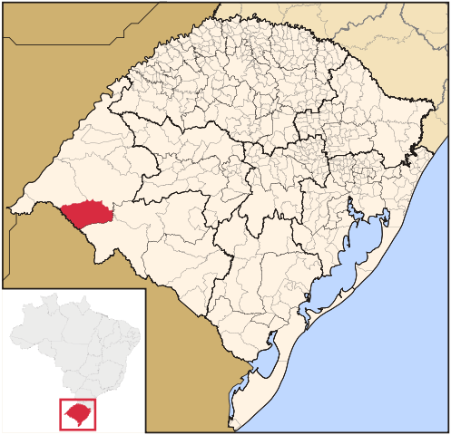
Raphael Lorenzeto de Abreu (CC-BY-SA)

Textaktualisierung vom 3. August 2020

Andere Namen: Quarahi, Quarahim, Quaraí

Die brasilianische Behörde für Geografie und Statistik (IBGE) schreibt auf ihrer Website, dass Quaraís Besiedlung in 1816 am rechten Ufer des gleichnamigen Flusses begann. Damals wurde ein Militärcamp für 200 Mann unter dem Befehlshaber José de Abreu errichtet. Der Landbesitzer hieß João Baptista de Castilhos, er kam aus Sorocaba (SP) und war Maultierhändler.

Der Fluss Quaraí stellt noch heute die natürliche Grenze zwischen Brasilien und Uruguay dar, wie bereits 1858 durch den Ingenieur José da Victória S. Andreia demarkiert wurde. Im folgenden Jahr gründete man die Pfarrei (freguesia) São João Baptista de Quarahy, als zweiten Bezirk der Gemeinde von Alegrete. In 1875 wurde Quarahy eine eigenständige Gemeinde (município), und laut Bericht des Präsidenten der Provinz Rio Grande von 1879, “ab 29. Juni (1878) startete die reguläre Postbeförderung zur neulich errichteten Postagentur von São João Baptista de Quarahy“.

Also ist der 29.06.1879 der Beginn des dortigen Postbetriebs; uns fehlt noch das Entstehungsdatum dieses Postamtes. Bisher sind drei verschiedene Stempel von dort bekannt:

QRS-0280a (Samml. Silvio Abelardo Canani): Ein einziges Exemplar bekannt, worauf man die Jahreszahl 1885 gerade noch lesen kann. Auf der gleichen Marke ein zweiter Stempel – in dunkelviolett – besagt: „(Corr)eio de P. Al(egre)“, womöglich ein Hinweis auf einen privaten Stafettenservice, wie damals in der Region üblich war.

QRS-0280b (Samml. FM): Zwei Exemplare auf Ausgabe Kreuz des Südens von 100 Réis bekannt, eines davon mit Datum 1889 (!). Hat ein Blätterzweig-Ornament unten, das aus vier Zweigen in Kreuzform besteht. Ist wohl ein Bahnstempel aus der Linie Uruguayana-Barra do Quarahy, seit 1887 in Betrieb.

QRS-0280c (Samml. José A. Junges): Zwei Exemplare, aus 1896 und aus 1899, mit der typischen Provinz-Inschrift „S. Pedro do Sul“. Dürfte später als QRS-0280b entstanden sein.

Categories
Carimbologia Q-R

Preliminary Notes

As stated in the print edition, additional texts to the Carimbologia do Brasil Clássico start hier and now. Readers’ remarks and corrections are welcome and can be posted either here or sent to jm-karlsruhe@web.de

available in Germany (arge-brasilien.de), Brazil (filatelicajunges.com.br) or on e-Bay

What you will find in the book: All important data are on pp. 8-9 (Preface and How to use). Every post office has a code with three letters and four numbers. The first letter refers to the topical name; the other two indicate the Brazilian province. The four numbers are identical with the last ones from the respective P.O. in List of the Postal Cancels in the Empire of Brazil (Wittig & Wittig, Lohmar, 2016). The same P.O. code is applied for its cancels, now completed by small letters (a, b, c, etc.). Thus, every cancel code refers directly to its province and to Wittig’s List as well.

Eventually, there are alternative local or train station names. Whenever Koester had already mentioned them, a respective marking is given.

Whenever possible, a small map was provided to every town or train station. This is generally marked in it with a red ellipse.

Almost all stamp pictures were digitally altered, to enable more clarity on their cancels. Their colours, size etc. can therefore differ from the original. Cancels, on the other hand, are supposed to be as close to the original as possible, even in cases when the original picture quality was unsatisfying.

Every cancel picture has its source (abbreviated) and applying time. Many examples of the same cancel in the archives mean a greater exactness in stating the period of use. Few examples of a cancel may lead to an estimation about it (abbreviated through “?, ff”, etc.).

Historical data is chronologically listed for all towns and train stations, occasionally accompanied by legal information (Alvará, Lei, Decreto-Lei, etc.). Thus, a cancel date can be checked with the town status. But please note: local names could switch in their cancels with considerable delay, especially in small villages. Moreover, it could take months or even years from creating to operating a P.O.

The main sources for population data are the Guia Postal do Império (1880) and the IBGE (Instituto Brasileiro de Geografia e Estatística), with estimated nunbers for 2018 and 2019. The reader can see how much a town population has increased (or decreased) between the given years. Besides, these numbers can give some hint about the rarity of a cancel. Considering that ca. 80 % of the population in imperial Brazil was illiterate – and in rural regions even more than that – a cancel from a village of about 1.000 people must have been seldom.

What you won’t find in the book. There is nothing about cancel colours, catalogue and action prices, or mute cancels. Such information can occasionally occur, provided they are relevant and confirmed. The main obstacle on describing colours in philately is the lack of international definition norms. In addition, modern technical devices have made the manipulation of colours quite easy, especially in the internet.

Acknowledgements. This work would not have been possible without the achievement of Reinhold Koester (1911-1994), who from 1961 on has published his research on cancels of Imperial Brazil in the Brasil Filatélico magazine (Clube Filatélico do Brasil, Rio de Janeiro) until initial P was completed.

Francisco da Nova Monteiro had already published his Brazilian P.O-list in the same magazine (Administrações e Agências Postaes do Brasil Império, 1934-5). In 1937, the Catálogo de Carimbos (Brasil-Império) by Paulo Ayres was released, and has become an indispensable work on this theme since then.

After Koester’s Carimbologia, Karlheinz Wittig published his List of the Postal Agencies in the Empire of Brazil with Dieter Kerkhoff in 1983 and republished it in 2016 (with Barbara Wittig, ArGe Brasilien). Finally, José Francisco de Paula Sobrinho wrote a splendid work about the História Postal de Minas Gerais in 1997.

Two outstanding websites must be mentioned, which both provided valuable help for this project through their actuality and accuracy: Paulo Novaes’s site on the postal agencies in the States of Rio de Janeiro and Espírito Santo (agenciaspostais.com.br) and Ralph M. Giesbrecht’s, on the Brazilian railroads (estacoesferroviarias.com.br).

It was absolutely necessary to build a data bank with Brazilian imperial cancels, so must the author express his gratefulness to the suppliers of these images. First of all and in name of his colleagues, to the philatelist and stamp dealer José A. Junges, who has made scans of his long-term collection of imperial cancels available. This was partly originated from the Koester estate. Junges has good reasons to see himself as a co-author of this work.

Furthermore, many other philatelists from several countries have contributed with images, suggestions, corrections and also critics. At a time when philately seems to become a niche for a minority interested in History and Culture, such an engagement will keep this History and Culture alive. The author is therefore deeply indebted to all of them.

Categories
Carimbologia Q-R

Abouts

Hello everybody. Here is Fabio Monteiro, a Brazilian/German philatelist who once upon a time decided to finish Reinhold Koesters (1911-1994) Carimbologia do Brasil Clássico, an extensive study upon early Brazilian post offices and their cancels. This study in alphabetical order was stopped in 1992, at the end of letter P. In October 2019, a 92 page booklet was released with the post offices of Imperial Brazil with letters Q and R. And here is the site where additional information, comments and corrections about it are to be found.

Aachen, Fall/Herbst 1981

Guten Tag. Hier schreibt Fabio Monteiro, ein deutsch-brasilianischer Philatelist der sich eines Tages entschloss, die Carimbologia do Brasil Clássico von Reinhold Koester (1911-1994) zu Ende zu bringen. Diese ausführliche Studie über brasilianische Postämter und ihre Abstempelungen zwischen 1798 und 1899 wurde in 1992 abgebrochen, am Ende von Buchstabe P. In Oktober 2019 wurde die Reihe fortgesetzt, mit einem 92-seitigen Büchlein über die Postämter im kaiserlichen Brasilien, die mit Q und R beginnen. In diesem Blog findet man die Ergänzungstexte, Kommentare und Korrekturen dazu.