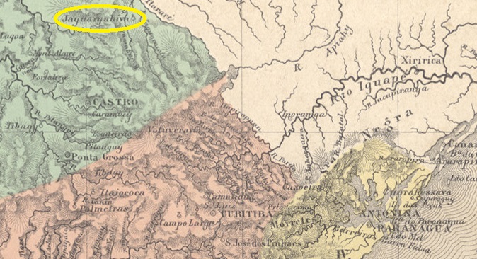
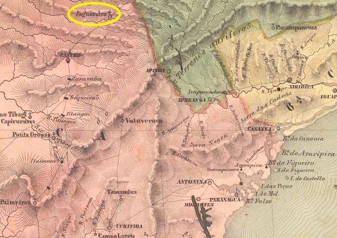
The beautiful word Jaguariahyva comes from the Tupi-guarani and means river of the aggressive jaguars. In 1795, this was the name of a fazenda on the west bank of the Jaguariaíva (the current spelling), 230 kilometres north of the future provincial capital of Curitiba. In September 1823, the settlement became the Freguesia de Senhor Bom Jesus da Pedra Fria de Jaguaryahiva, which belonged to the Vila de Castro. The Freguesia became a Vila in April 1875 and the Vila was elevated to a town in May 1908.
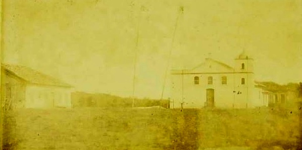
Main church (around 1890)
Nova Monteiro writes in Administrações e Agencias Postaes do Brasil Imperio (Brasil Filatelico/RJ, 1934-5; reprint SPP 1994-1999) that in August 1864 it was decided to establish a local post office, which is confirmed by the Rio press:
Diario do Rio de Janeiro, 31.08.1864
However, as no Jaguariahyva postal agency is mentioned in the following years, the post office started to operate probably only in 1868, as can be seen from the list of imperial post offices (Tabella das Agencias do Correio do Imperio, Rio de Janeiro, 1885).
The only imperial postmark to date is JPR-0255a (fig. R. Koester in Carimbologia XXV):
JPR-0255a (RK) 1880Villiers de l’Ile Adam: Carta (…) da Provincia de São Paulo, 1847
Andere Schreibweisen: Jaguaryahiva, Jaguariaíva
Das schöne Wort Jaguariahyva stammt aus dem Tupi-guarani und bedeutet Fluss der angriffslustigen Jaguare. So hieß 1795 eine Fazenda am Westufer des Jaguariaíva (so die heutige Schreibweise), 230 km nördlich der späteren Provinzhauptstadt Curitiba. Im September 1823 wurde aus der Siedlung die Freguesia de Senhor Bom Jesus da Pedra Fria de Jaguaryahiva, die zur Vila de Castro gehörte. Die Freguesia wurde im April 1875 zur Vila und diese im Mai 1908 zur Stadt erhoben.
Hauptkirche um 1890
Nova Monteiro schreibt in Administrações e Agencias Postaes do Brasil Imperio (Brasil Filatelico/RJ, 1934-5; Reprint SPP 1994-1999), dass im August 1864 beschlossen wurde, ein Postamt vor Ort zu errichten, was durch die Presse aus Rio bestätigt wird:
Diario do Rio de Janeiro, 31.08.1864
Da aber in den folgenden Jahren keine Postagentur Jaguariahyva erwähnt wird, wurde das Postamt vermutlich erst 1868 aktiv, wie aus dem Verzeichnis der kaiserlichen Postämter (Tabella das Agencias do Correio do Imperio, Rio de Janeiro, 1885) hervorgeht.
Der bisher einzige kaiserliche Poststempel ist JPR-0255a (Abb. R. Koester in Carimbologia XXV):
Colton & Colton: Provincia do Rio de Janeiro, 1880
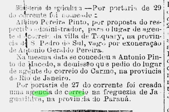
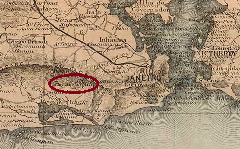
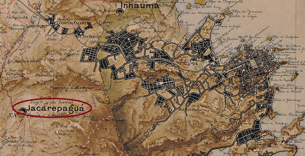
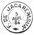
The Freguesia de N. Sra. de Loreto de Jacarepaguá, located 30 kilometres west of the capital Rio de Janeiro and since July 1981 an administrative district (Região Administrativa) of the Município do Rio de Janeiro, has been documented since 1661. The place name comes from the Tupi-guarani and means bay of crocodiles.
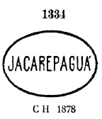
According to the list of imperial post offices (Tabella das Agencias do Correio do Imperio, Rio de Janeiro, 1885), there had been a post office there since 1878, which was closed around 1937 according to P. Novaes (agenciaspostais.com.br). The oldest postmark is JMN-2315a, which was given the no. 1334 by P. Ayres in Catálogo de Carimbos Brasil-Império (S. Paulo, 1937, 1942):
JMN-2315a (P.A. 1334) 1878ff
This was followed by the double circle JMN-2315b (fig. R. Koester, in Carimbologia XXV):
JMN-2315b (RK) 1882-1885Mappa do Municipio Neutro, ca. 1880
Seit 1661 ist die Freguesia de N. Sra. de Loreto de Jacarepaguá, 30 km westlich der Hauptstadt Rio de Janeiro gelegen und seit Juli 1981 ein Verwaltungsbezirk (Região Administrativa) des Município do Rio de Janeiro, bezeugt. Der Ortsname kommt aus dem Tupi-guarani und bedeutet Bucht der Krokodile.
Wie aus dem Verzeichnis der kaiserlichen Postämter (Tabella das Agencias do Correio do Imperio, Rio de Janeiro, 1885) hervorgeht, gab es dort seit 1878 ein Postamt, das nach P. Novaes (agenciaspostais.com.br) um 1937 geschlossen wurde. Der älteste Poststempel ist JMN-2315a, der von P. Ayres in Catálogo de Carimbos Brasil-Império (S. Paulo, 1937, 1942) die Nr. 1334 erhielt:
JMN-2315a (P.A. 1334) 1878ff
Es folgte der Doppelkreis JMN-2315b (Abb. R. Koester, in Carimbologia XXV):
Villiers de l’Ile Adam: Carta (…) das Provincias do Rio Grande do Norte e Parahiba, 1848
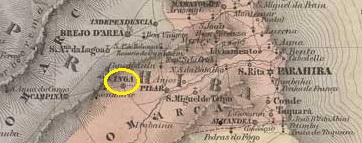
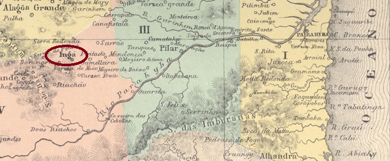
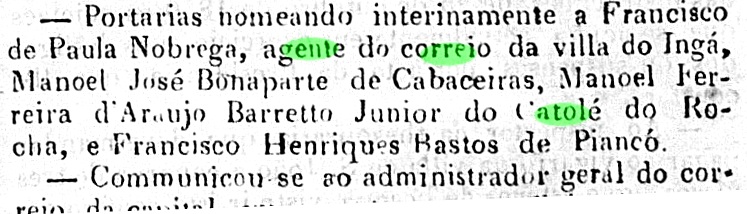
The indigenous word Ingá means ‘plenty of water’, which is vital in the drought-stricken region. A settlement was established around 1776 on the west bank of the Ingá, 100 kilometres west of the later provincial capital of Parahyba (now João Pessoa). The Freguesia de N. Sra. do Rosário de Ingá was established there around 1800 on the territory of the Vila de Pilar, which was elevated to the status of Vila do Imperador in July 1841. The place name Ingá was reintroduced in May 1846, presumably due to the risk of confusion with vilas of the same name in the empire. In May 1900, the town was downgraded to a distrito, but regained the status of a vila in November 1904.
Three periods of operation were found for the local post office. The first was decided in March 1847, as Nova Monteiro writes in Administrações e Agencias Postaes do Brasil Imperio (Brasil Filatelico/RJ, 1934-5; reprint SPP 1994-1999). This is confirmed by the report of the Ministry of the Empire:
Relatorio do Ministerio do Imperio, 1847
This first period of operation ended around 1850:
Relatorio do Ministerio do Imperio, 1850
However, the postal agency was back in operation by the following year at the latest:
O Governista Parahybano, 18/06/1851
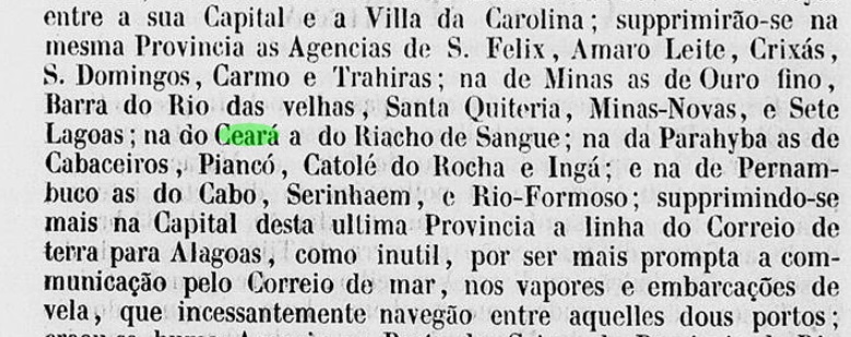
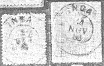
It is not known when this second period ended; the next opening took place in August 1858, as can be seen from the postal report (Relatorio dos Correios) of 1886. R. Koester has provided two illustrations of the only imperial postmark to date, IPB-0140b, in Carimbologia XXII:
IPB-0140b (RK) 1883ff-1886Atlas do Imperio do Brasil, 1868
Das indigene Wort Ingá bedeutet “viel Wasser”, was in der von Trockenheit geplagten Region lebenswichtig ist. Eine Siedlung entstand um 1776 am Westufer des Ingá, 100 km westlich der späteren Provinzhauptstadt Parahyba (heute João Pessoa). Dort entstand um 1800 die Freguesia de N. Sra. do Rosário de Ingá auf dem Gebiet der Vila de Pilar, die im Juli 1841 zur Vila do Imperador erhoben wurde. Vermutlich wegen Verwechslungsgefahr mit gleichnamigen Vilas im Kaiserreich wurde der Ortsname Ingá im Mai 1846 wieder eingeführt. Im Mai 1900 wurde der Ort zum Distrito herabgestuft, erhielt aber im November 1904 den Status einer Vila zurück.
Für das örtliche Postamt wurden drei Betriebszeiträume gefunden. Die erste wurde im März 1847 beschlossen, wie Nova Monteiro in Administrações e Agencias Postaes do Brasil Imperio (Brasil Filatelico/RJ, 1934-5; Nachdruck SPP 1994-1999) schreibt. Dies wird durch den Bericht des Ministeriums des Imperiums bestätigt:
Relatorio do Ministerio do Imperio, 1847
Diese erste Betriebsperiode endete um 1850:
Relatorio do Ministerio do Imperio, 1850
Spätestens im folgenden Jahr war die Postagentur jedoch wieder in Betrieb:
O Governista Parahybano, 18.06.1851
Wann diese zweite Periode endete, ist nicht bekannt; die nächste Eröffnung erfolgte im August 1858, wie aus dem Postbericht (Relatorio dos Correios) von 1886 hervorgeht. Von dem bisher einzigen kaiserlichen Poststempel IPB-0140b hat R. Koester in Carimbologia XXII zwei Abbildungen geliefert:
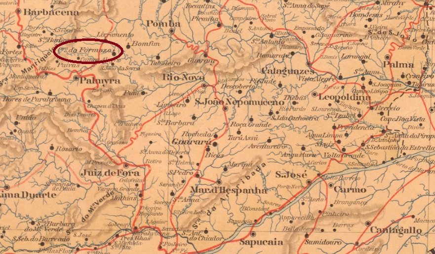
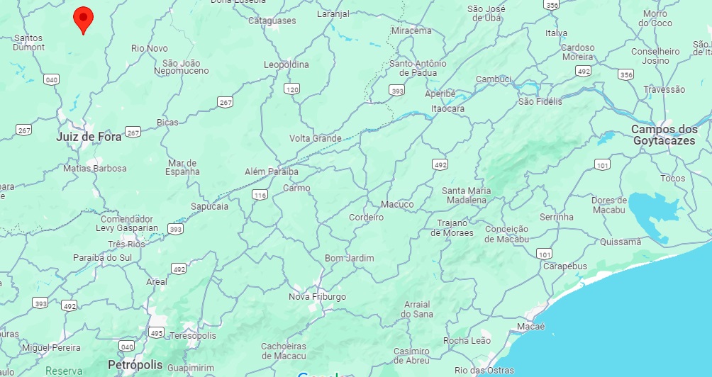
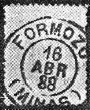
In September 1887, the Freguesia N. Sra. da Conceição do Formoso was founded, which belonged to the Vila de Barbacena and was located on the east bank of the Formoso, 200 km south of the capital Ouro Preto. In July 1889, the freguesia was transferred to the Vila de Palmira and has been a district of the Município de Santos Dumont since July 1932.
As Paula Sobrinho (História Postal de Minas Gerais, Belo Horizonte, 1997) and R. Koester (Carimbologia XIX) agree, there had been a post office there since January 1888. The imperial postmark is FMG-1190a (RK):
FMG-1190a (RK) 1888Google Maps
Andere Namen: Conceição do Formoso
Im September 1887 wurde die Freguesia N. Sra. da Conceição do Formoso gegründet, die zur Vila de Barbacena gehörte und am Ostufer des Formoso lag, 200 km südlich der Hauptstadt Ouro Preto. Im Juli 1889 wechselte die Freguesia zur Vila de Palmira und ist seit Juli 1932 ein Distrikt des Município de Santos Dumont.
Wie Paula Sobrinho (História Postal de Minas Gerais, Belo Horizonte, 1997) und R. Koester (Carimbologia XIX) übereinstimmend schreiben, gab es dort seit Januar 1888 ein Postamt. Der kaiserliche Poststempel ist FMG-1190a (RK):
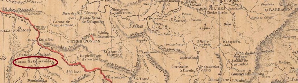
Other names: N. Sa. do Carmo dos Tocos, Carmo da Escaramuça dos Ciganos, Paraguaçu (1911)
The village was a curato of the Vila de Sto Antonio do Machado around 1828, near the west bank of the Sapucaí, 390 km southwest of the provincial capital Ouro Preto. In March 1840 it became the Freguesia de N. Sra. do Carmo da Escaramuça and in August 1911 the Município de Paraguaçu.
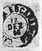
Again, Paula Sobrinho (História Postal de Minas Gerais, Belo Horizonte, 1997) and R. Koester (Carimbologia IX) agree on the February 1872 foundation date for the local post office. Accordingly, there must have been another postmark before CMG-0640b (Fig.: R. Koester):
CMG-0640b (RK) 1887-1898ffProvincia de Minas Geraes, 1873
Andere Namen: N. Sa. do Carmo dos Tocos, Carmo da Escaramuça dos Ciganos, Paraguaçu (1911)
Der Ort war um 1828 ein Curato der Vila de Sto Antonio do Machado, nahe dem Westufer des Sapucaí, 390 km südwestlich der Provinzhauptstadt Ouro Preto. Im März 1840 wurde es zur Freguesia de N. Sra. do Carmo da Escaramuça und im August 1911 zum Município de Paraguaçu.
Auch hier sind sich Paula Sobrinho (História Postal de Minas Gerais, Belo Horizonte, 1997) und R. Koester (Carimbologia IX) über das Gründungsdatum im Februar 1872 für das örtliche Postamt einig. Demnach muss es vor CMG-0640b (Abb.: R. Koester) noch einen anderen Poststempel gegeben haben:
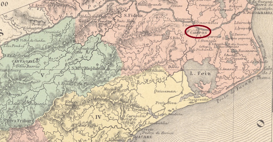
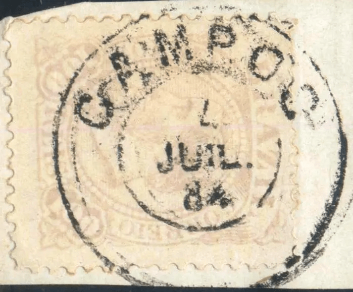
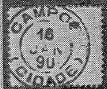
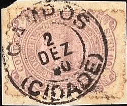
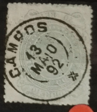
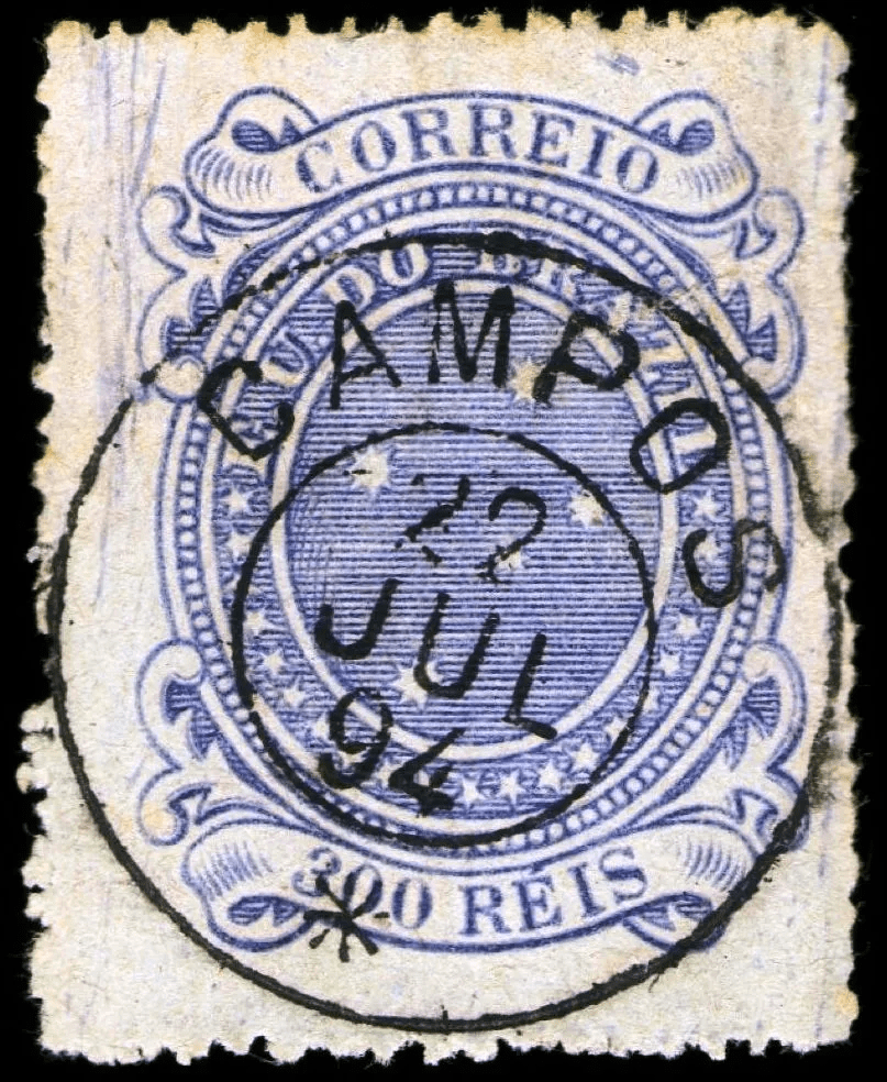
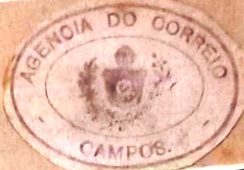
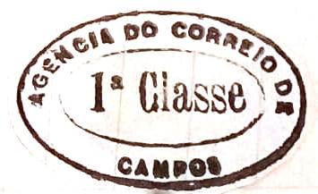
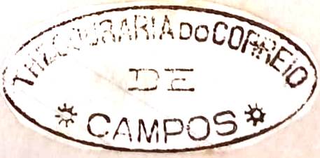
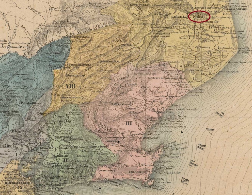
The locality, which first became a vila in 1673 and a freguesia the following year, was called São Salvador dos Campos and was on the south bank of the Paraíba do Sul, 280 km northeast of the capital Rio de Janeiro. In 1753, Campos still belonged to the Capitania do Espirito Santo (very formerly also to the Capitania of S. Thomé), but in August 1832 it changed to the imperial province of Rio de Janeiro. Since March 1835 Campos has been a town, and since October 1986 it has been called Campos dos Goitacazes.
The local post office existed as early as 1798, although Nova Monteiro in Administrações e Agencias Postaes do Brasil Imperio (Brasil Filatelico/RJ, 1934-5; reprinted by SPP 1994-1999) still gives February as the date of creation, while Paulo Novaes on agenciaspostais.com.br writes a more accurate date of June that year.
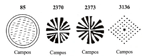
The first postmark is CRJ-0285a, with No. 1135 by P. Ayres (Catálogo de Carimbos Brasil-Império, S. Paulo, 1937, 1942), but the RHM catalogue shows an altered image under P-RJ-04:
CRJ-0285a (P.A. 1135, recte RHM P-RJ-04) 1826-1838 (also in brown)
It was followed by CRJ-0285b, also known from Ayres (op. cit.), now under No. 1256:
CRJ-0285b (P.A. 1256, RHM P-RJ-06) 1839-1869 (also in red)
The enigmatic cancel CRJ-0285c also appeared in red and sepia from around 1843. According to new findings, the letters S.I. mean Serviço Imperial:
CRJ-0285c (RHM P-RJ-05) 1843ff-1850gg
From about 1868 onwards, the French type CRJ-0285d appears (Fig. José L. Fevereiro)
CRJ-0285d (JLF) 1868-1880
In the early 1980s, two almost identical cancels appeared, differing only by the numbers 1 and 2 at the bottom: CRJ-0285e (illustration from the Internet) and CRJ-0285f (illustration by Luiz C. Fritzen):
CRJ-0285e (EB) 1884-1893CRJ-0285f (LCF) 1881-1888
Around the same time, the simple CRJ-0285g (image from the internet) was also in service:
CRJ-0285g (EB) 1884-1888
Towards the end of the Empire, two identical postmarks appeared again, this time differing in letter size: CRJ-0285h (ill. R. Koester, in Carimbologia VIII) and CRJ-0285i (ill. from the Internet):
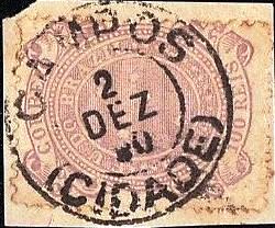
CRJ-0285 h (RK) 1888-1890CRJ-0285i (EB) 1888-1899
The last two 19th century postmarks may already be Republican, as they are dated after the November 1889 coup d’état:
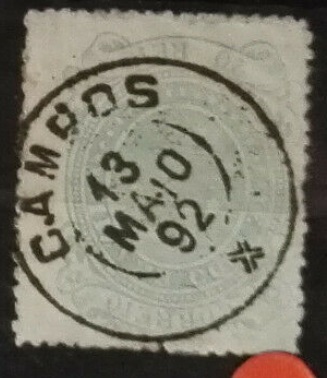
CRJ-0285j (EB) 1891-1899CRJ-0285k (CC) 1894-1896
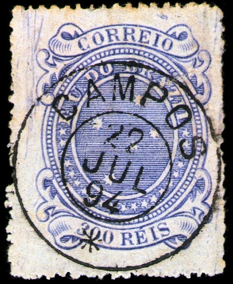
From the Fuad Ferreira Fo. collection there also came three other postmarks from Campos that were formerly in the Koester collection:
CRJ-0285f (FF/RK)CRJ-0285m (FF/RK)s.d. (FF/RK)
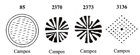
Five mute cancellations from the imperial Campos have been found so far, the first four of them in Mute Cancellations of the Brazil Empire / Carimbos Mudos do Brasil Império (Brazil Philatelic Association, Rio de Janeiro, 2000), by J. Dingler and K. W. Lopes:
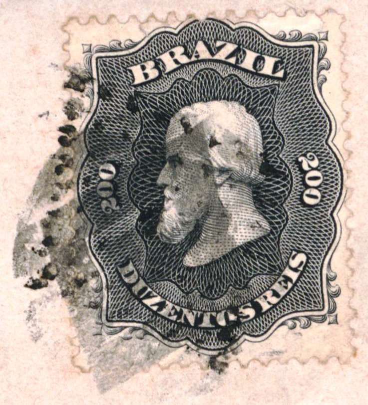
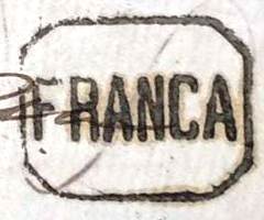
Last we have a FRANCA postmark (= fee paid to consignee) from Campos on a cover of José L. Fevereiro:
1877 (JLF)Villiers de l’Ile Adam: Carta (…) da Provincia do Rio de Janeiro, 1850
Textaktualisierung am 30. September 2023
Anderer Name: Campos dos Goitacazes (1986)
Der Ort, der 1673 zunächst eine Vila und erst im folgenden Jahr eine Freguesia wurde, hieß São Salvador dos Campos und lag am Südufer des Paraíba do Sul, 280 km nordöstlich der Hauptstadt Rio de Janeiro. Im Jahre 1753 gehörte Campos noch zur Capitania do Espirito Santo (ganz früher auch zur Capitania von S. Thomé), wechselte aber im August 1832 zur kaiserlichen Provinz Rio de Janeiro. Seit März 1835 ist Campos eine Stadt, die seit Oktober 1986 Campos dos Goitacazes heißt.
Das örtliche Postamt existierte bereits 1798, wobei Nova Monteiro im Administrações e Agencias Postaes do Brasil Imperio (Brasil Filatelico/RJ, 1934-5; Nachdruck SPP 1994-1999) noch den Februar als Gründungsdatum angibt, während Paulo Novaes auf agenciaspostais.com.br ein genaueres Datum im Juni d.J. schreibt.
Der erste Poststempel ist CRJ-0285a von P. Ayres (Catálogo de Carimbos Brasil-Império, S. Paulo, 1937, 1942) mit der Nr. 1135 versehen. Der RHM-Katalog zeigt jedoch eine veränderte Abbildung unter P-RJ-04:
CRJ-0285a (P.A. 1135, recte RHM P-RJ-04) 1826-1838 (auch in braun)
Gefolgt von CRJ-0285b, ebenfalls bekannt von Ayres (op. cit.), jetzt unter Nr. 1256:
CRJ-0285b (P.A. 1256, RHM P-RJ-06) 1839-1869 (auch in rot)
Der rätselhafte Stempel CRJ-0285c erschien um 1843 auch in Rot und Sepia. Die Buchstaben S.I. bedeuten nach neuen Erkenntnissen Serviço Imperial:
CRJ-0285c (RHM P-RJ-05) 1843ff-1850ff
Ab ca. 1868 erscheint der französische Typ CRJ-0285d (Abb. José L. Fevereiro)
CRJ-0285d (JLF) 1868-1880
Anfang der 80er Jahre erschienen zwei fast identische Stempel, die sich nur durch die Ziffern 1 und 2 unten unterscheiden: CRJ-0285e (Abb. aus dem Internet) und CRJ-0285f (Abb. Luiz C. Fritzen):
CRJ-0285e (EB) 1884-1893CRJ-0285f (LCF) 1881-1888
Parallel dazu war auch die einfache CRJ-0285g (Bild aus dem Internet) im Einsatz:
CRJ-0285g (EB) 1884-1888
Gegen Ende des Kaiserreichs erschienen wieder zwei gleichlautende Poststempel, die sich diesmal durch die Buchstabengröße unterscheiden: CRJ-0285h (Abb. R. Koester, in Carimbologia VIII) und CRJ-0285i (Abb. aus dem Internet):
CRJ-0285h (RK) 1888-1890CRJ-0285i (EB) 1888-1899
Die beiden letzten Poststempel des 19. Jahrhunderts können bereits republikanisch sein, da sie nach dem Staatsstreich vom November 1889 datiert sind:
CRJ-0285j (EB) 1891-1899CRJ-0285k (CC) 1894-1896
Aus der Sammlung Fuad Ferreira Fo. kamen auch drei weitere Poststempel aus Campos, die früher in der Sammlung Koester waren:
CRJ-0285l (FF/RK)CRJ-0285m (FF/RK)s.d. (FF/RK)
Bisher wurden fünf stumme Abstempelungen aus dem kaiserlichen Campos gefunden, die ersten vier davon in Mute Cancellations of the Brazil Empire / Carimbos Mudos do Brasil Império (Brazil Philatelic Association, Rio de Janeiro, 2000), von J. Dingler und K. W. Lopes:
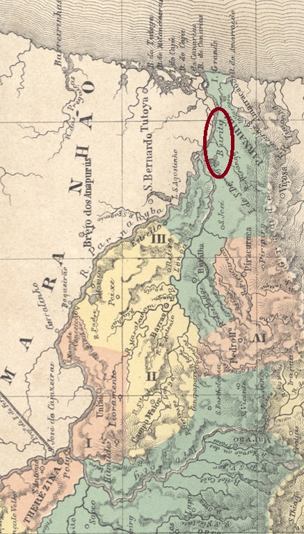
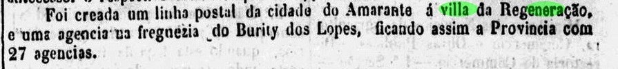
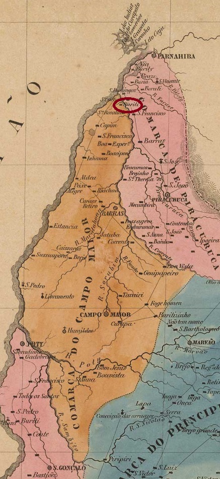
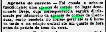
The Freguesia de N. Sa. dos Remedios de Burity dos Lopes was founded in June 1864 on the east bank of the river Longá in the Município of Parnaíba, 300 km north of the provincial capital Teresina. It was elevated to the status of a villa in August 1890 and was given the name Baixo Longá in June 1897. In July 1911, the old place name Buriti dos Lopes returned. After a good two years (June 1931 to September 1933) as a district of Parnaíba, Burity dos Lopes became an independent município again. The name commemorates the first Portuguese settler, Francisco Lopes.
Two foundation dates were found for the local post office. The first one in October 1884, as the Rio press wrote:
Gazeta de Noticias/RJ, 05.10.1884
Then again in 1885, as stated in the regional press:
A Imprensa, 07.09.1885
No imperial postmark of Burity dos Lopes has been found so far.
Villiers de l’Ile Adam: Carta (…) da Provinica do Piauhy, 1850
Anderer Name: Baixo Longá
Die Freguesia de N. Sa. dos Remedios de Burity dos Lopes wurde im Juni 1864 gegründet und lag am Ostufer des Flusses Longá im Município von Parnaíba, 300 km nördlich der Provinzhauptstadt Teresina. Im August 1890 wurde sie zur Vila erhoben und erhielt im Juni 1897 den Namen Baixo Longá. Im Juli 1911 kehrte der alte Ortsname Buriti dos Lopes zurück. Nach gut zwei Jahren (Juni 1931 bis September 1933) als Distrikt von Parnaíba wurde Burity dos Lopes wieder ein eigenständiges Município. Der Name erinnert an den ersten portugiesischen Siedler, Francisco Lopes.
Für das örtliche Postamt wurden zwei Entstehungsdaten gefunden. Die erste im Oktober 1884, wie die Presse in Rio schrieb:
Gazeta de Noticias/RJ, 05.10.1884
Dann wieder 1885, wie aus der regionalen Presse hervorgeht:
A Imprensa, 07.09.1885
Bisher wurde kein kaiserlicher Poststempel von Burity dos Lopes gefunden.
Other names: Sto. Antonio de Jacutinga, Belford Roxo (1938)
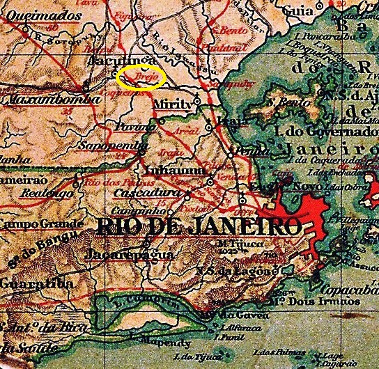
The history of this village begins around 1800, with the creation of the Fazenda do Brejo in the Freguesia of Maxambomba on the north bank of the Sarapuí River, 30 km northwest of the capital Rio de Janeiro. The settlement grew rapidly and in January 1833 became the freguesia of Sto. Antonio da Jacutinga, which belonged to the Município of Iguaçu.
Fifty years later, a station of the E.F. Rio d’Ouro railway company (Branch Line) was inaugurated there. In 1927, the railway line became the property of the E.F. Central do Brasil. In December 1938, the Freguesia do Brejo became a district called Belford Roxo, which now belonged to the Município of Nova Iguaçu, and has been an independent Município since April 1990. De name pays tribute to the engineer Raymundo Teixeira Belfort Roxo (1838-1896, spelled with a t), who was responsible for the water supply in Rio de Janeiro at the end of the century.
The railway line changed hands again in 1975 to Rede Ferroviária Federal S.A. and has belonged to the Supervias consortium since 1997.
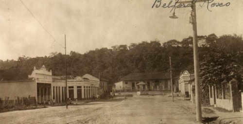
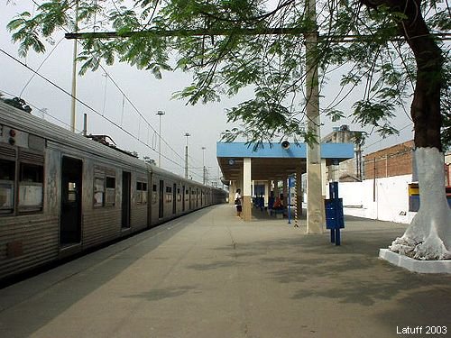
Brejo station, ca. 1920 (Photo: Wanderley Duck, in estacoesferroviarias.com.br)Belford Roxo station, 2003 (Photo: Carlos Latuff, in estacoesferroviarias.com.br)
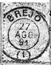
As reported by the Rio press, there had been a post office on site since November 1872:
Jornal do Commercio, 22.11.1872
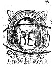
The first postmark is BRJ-0210a, used until at least 1877 and already known through R. Koester (Carimbologia VI):
BRJ-0210a (RK) 1872-1877ff.
Its successor BRJ-0210b was also shown to us by Koester (op. cit.). This postmark could be from a post office at the railway station, but the corresponding confirmation is still missing.
BRJ-0210b (RK) 1891-1894
The third postmark BRJ-0210c can also be seen at Koester:
BRJ-0210c (RK)Almanak Laemmert, 1892
Andere Namen: Sto. Antonio de Jacutinga, Belford Roxo (1938)
Die Geschichte dieser Ortschaft fängt um 1800 an, mit der Entstehung der Fazenda do Brejo in der Freguesia von Maxambomba am Nordufer des Flusses Sarapuí, 30 km nordwestlich der Hauptstadt Rio de Janeiro. Die Siedlung wuchs schnell und wurde im Januar 1833 die Freguesia von Sto. Antonio da Jacutinga, die dem Município von Iguaçu zugeordnet war.
Fünfzig Jahre später wurde dort ein Bahnhof der E.F. Rio d’Ouro Bahngesellschaft (Nebenlinie) eingeweiht. 1927 ging die Bahnlinie in Besitz der E.F. Central do Brasil. Im Dezember 1938 wurde aus der Freguesia do Brejo ein Distrikt namens Belford Roxo, der nun dem Município von Nova Iguaçu gehörte und seit April 1990 ein eigenständiger Município ist. Der Name zollt Tribut an den Ingenieur Raymundo Teixeira Belfort Roxo (1838-1896, mit t geschrieben), der am Ende des Jahrhunderts für die Wasserversorgung in Rio de Janeiro zuständig war.
Die Bahnlinie wechselte abermals 1975 zur Rede Ferroviária Federal S.A. und gehört seit 1997 dem Konsortium Supervias an.
Bahnhof Brejo, ca. 1920 (Foto: Wanderley Duck, in estacoesferroviarias.com.br)Bahnhof Belford Roxo, 2003 (Foto: Carlos Latuff, in estacoesferroviarias.com.br)
Wie die Presse aus Rio berichtete, gab es vor Ort ein Postamt seit November 1872:
Jornal do Commercio, 22.11.1872
Der erste Poststempel ist BRJ-0210a, der bis mindestens 1877 verwendet wurde und bereits durch R. Koester (Carimbologia VI) bekannt ist:
BRJ-0210a (RK) 1872-1877ff
Seinen Nachfolger BRJ-0210b zeigte uns auch Koester (op.cit.). Dieser Poststempel könnte aus einem Postamt am Bahnhof sein, allerdings fehlt die entsprechende Bestätigung.
BRJ-0210b (RK) 1891-1894
Auch der dritte Poststempel BRJ-0210c ist bei Koester zu sehen:
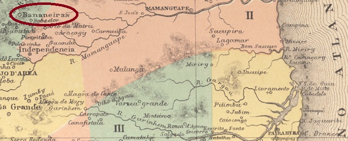
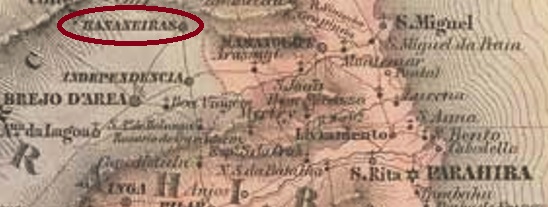
Bananeiras (Banana plants) was a settlement belonging to the vila of S. Miguel da Bahia da Traição, located 130 km northwest of the capital Parahyba do Norte (today: João Pessoa). In 1827, the local jurisdiction changed to the Vila of Areia and became a Vila in May 1833. Bananeiras has been a town since October 1879.
Nova Monteiro writes in Administrações e Agencias Postaes do Brasil Imperio (Brasil Filatelico/RJ, 1934-5; Reprint SPP 1994-1999) that there was a post office there since April 1835. This information is confirmed by the postal report (Relatorio Postal) for 1887. The only postmark of the imperial period so far is BPB-0045c, found with dates between 1884 and 1889 and already known by R. Koester in Carimbologia III:
BPB-0045c (RK) 1884-1889Villiers de l’Ile Adam: Carta (…) das Provincias do Rio Grande do Norte e Parahiba, 1848
Bananeiras (Bananenstauden) war eine Siedlung die zur Vila von S. Miguel da Bahia da Traição gehörte und 130 km nordwestlich der Hauptstadt Parahyba do Norte (heute: João Pessoa) lag. 1827 wechselte die Ortszuständigkeit zur Vila von Areia und wurde im Mai 1833 eine Vila. Seit Oktober 1879 ist Bananeiras eine Stadt.
Nova Monteiro schreibt in Administrações e Agencias Postaes do Brasil Imperio (Brasil Filatelico/RJ, 1934-5; Reprint SPP 1994-1999), dass es dort seit April 1835 ein Postamt existierte. Diese Angabe wird durch den Postbericht (Relatorio Postal) für 1887 bestätigt. Der bisher einzige Poststempel der Kaiserzeit ist BPB-0045c, der mit Daten zwischen 1884 und 1889 gefunden wurde und bereits durch R. Koester in Carimbologia III bekannt ist:
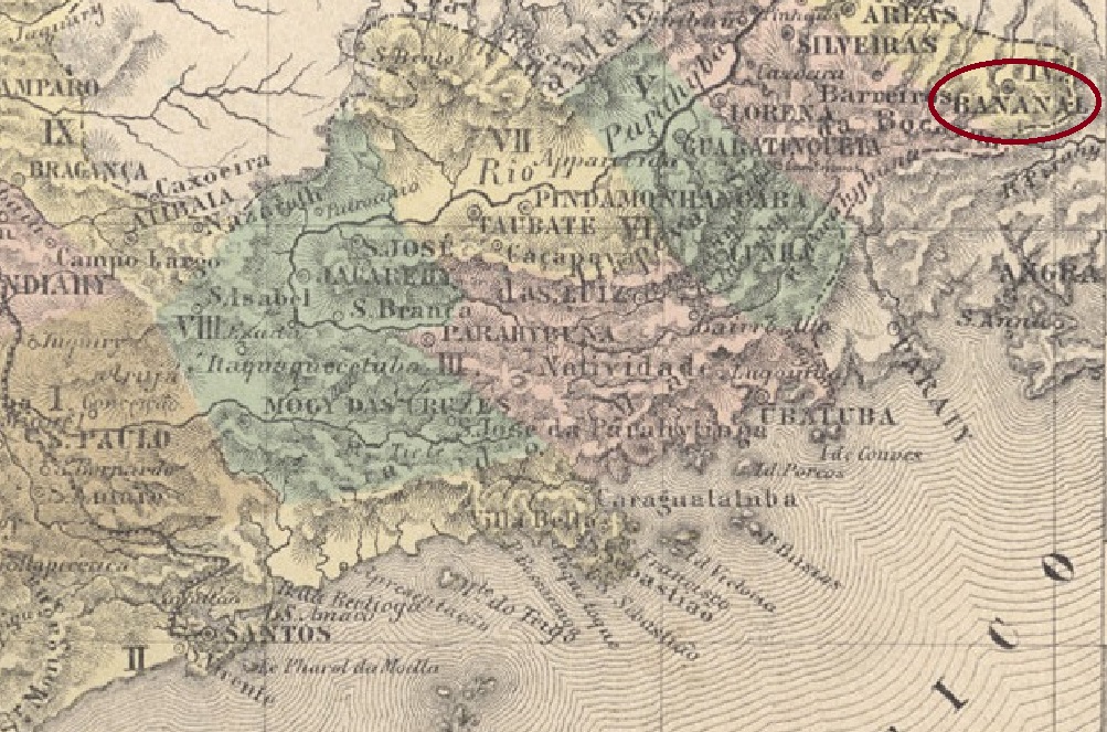
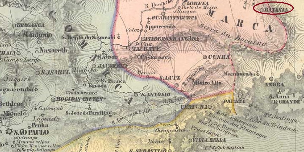
The Freguesia of Senhor Bom Jesus do Livramento do Bananal was founded in January 1811 by royal decree (Alvará Real) and was located on the south bank of the Bananal River at the Vila of Lorena, 320 km east of the provincial capital São Paulo. In November 1816, the jurisdiction changed: now it belonged to the Vila of Areias. In July 1832 Bananal became a vila and in April 1849 a town.
It has not yet been possible to find the date of origin of the local post office. Nova Monteiro (Administrações e Agencias Postaes do Brasil Imperio, in Brasil Filatelico/RJ, 1934-5; Reprint SPP 1994-1999) only writes about the appointment of a postal agent in December 1848. It is certain that there was already a functioning postal system in the village in August 1829, as reported in the regional press:
O Novo Farol Paulistano, 02.09.1829
The Directory of Imperial Post Offices (Tabella das Agencias do Correio do Imperio, Rio de Janeiro, 1885) lists a post office opening in 1856 in Bananal. However, this is probably a misprint, as neither the postal guide (Guia do Correio do Brasil) nor the imperial ministerial report (Relatorio do Ministerio do Imperio) for 1857 can confirm this information.
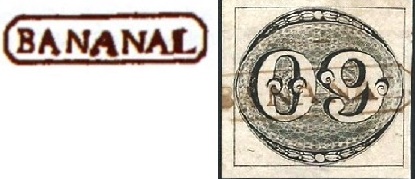
Regarding the postmarks: the first is BSP-0090a, which also occurs in brown and was already seen in the RHM catalogue under P-SP-04. However, the dot after the place name is missing in the illustration, as can be seen at right (Mario Celso Orsi Jr.):
BSP-0090a (RHM P-SP-04 – recte MO) 1830-1843ff
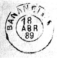
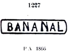
It was followed by BSP-0090b, known by Paulo Ayres (Catálogo de Carimbos Brasil-Império, S. Paulo, 1937, 1942) under no.1227:
BSP-0090b (P.A. 1227) 1866-1877ff
Then came the French type BSP-0090c, also shown in the Paulo Ayres (op. cit.):
BSP-0090c (P.A. p 117) 1877-1886
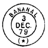
The last imperial postmark is BSP-0090d (image: Mario Celso Orsi Jr.), used from 1887 to 1896: a double circle with the inscription BANANAL above and a (C) – for Cidade – below.
Between BSP-0090a and BSP-0090b a handwritten cancellation (image: Mário Celso Orsi Jr.) was used:
(MO) 1844ff
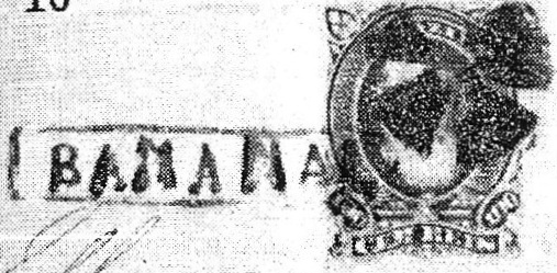
Finally, R. Koester (Carimbologia III) also presented a mute cancellation from Bananal:
(RK) 1879Villiers de l’Ile Adam: Carta (…) da Provincia de S. Paulo, 1847
Die Freguesia von Senhor Bom Jesus do Livramento do Bananal wurde im Januar 1811 durch königliche Verfügung (Alvará Real) gegründet und lag am Südufer des Flusses Bananal bei der Vila von Lorena, 320 km östlich der Provinzhauptstadt São Paulo entfernt. Im November 1816 wechselte die Zuständigkeit: nun gehörte sie der Vila von Areias. Im Juli 1832 wurde aus Bananal eine Vila und im April 1849 eine Stadt.
Es ist bisher nicht gelungen, den Entstehungstermin fürs örtliche Postamt zu ermitteln. Nova Monteiro (Administrações e Agencias Postaes do Brasil Imperio, in Brasil Filatelico/RJ, 1934-5; Reprint SPP 1994-1999) schreibt lediglich über die Ernennung eines Postagenten im Dezember 1848. Sicher ist, dass bereits im August 1829 ein funktionierendes Postwesen vor Ort gab, wie die Regionalpresse berichtet:
O Novo Farol Paulistano, 02.09.1829
Das Verzeichnis der kaiserlichen Postämter (Tabella das Agencias do Correio do Imperio, Rio de Janeiro, 1885) listet eine Posteröffnung 1856 im Bananal auf. Das dürfte aber ein Druckfehler sein, denn weder der Postführer (Guia do Correio do Brasil) noch der kaiserliche Ministerialbericht (Relatorio do Ministerio do Imperio) für 1857 können diese Angabe bestätigen.
Zu den Poststempeln: der erste ist BSP-0090a, der auch in Braun vorkommt und bereits im RHM-Katalog unter P-SP-04 zu sehen war. Allerdings fehlt in der Abbildung der Punkt nach dem Ortsnamen, wie man in der Abbildung (Mario Celso Orsi Jr.) feststellen kann:
BSP-0090a (RHM P-SP-04 – recte MO) 1830-1843ff
Ihm folgte BSP-0090b, bekannt durch Paulo Ayres (Catálogo de Carimbos Brasil-Império, S. Paulo, 1937, 1942) unter Nr.1227:
BSP-0090b (P.A. 1227) 1866-1877ff
Danach kam der französische Typus BSP-0090c, auch im Paulo Ayres (op. cit.) abgebildet:
BSP-0090c (P.A. p/S. 117) 1877-1886
Der letzte kaiserliche Poststempel ist BSP-0090d (Abb. Mario Celso Orsi Jr.), der von 1887-1896 verwendet wurde: ein Doppelkreis mit der Inschrift BANANAL oben und einem (C) – für Cidade – unten.
Zwischen BSP-0090a und BSP-0090b wurde eine handschriftliche Entwertung (Abb. Mário Celso Orsi Jr.) benutzt:
(MO) 1844ff
Schließlich zeigte R. Koester (Carimbologia III) auch eine stumme Abstempelung aus Bananal: