Other names: São José do Itamonte, Itamonte (1938)
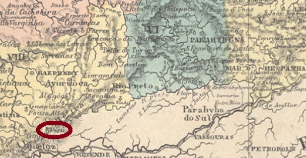
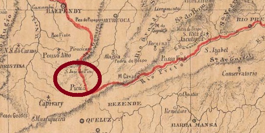
This place was a district of Pouso Alto, located on the River Capivari near the Serra da Mantiqueira, about 370 km southwest of the provincial capital Ouro Preto. In September 1923, it changed to the newly founded municipality of Itanhandu, and four years later it became the municipality of S. José do Itamonte, which since December 1938 was simply called Itamonte. The name is a composition of Ita (stone in tupi-guarani) and Monte (port. for mountain).
According to Paula Sobrinho (História Postal de Minas Gerais, Belo Horizonte, 1997), there has been a post office there since October 1873. An early cancel was to be found, unfortunately not the oldest. SMG-2475b (Coll. Márcio Protzner) is a double circle with the inscriptions S. JOSÉ DO PICÚ above and (MINAS) below. Dates at the centre so far: 1896 to 1906.
Provincia de Minas Geraes, 1873
Andere Namen: São José do Itamonte, Itamonte (1938)
Dieser Ort war seit September 1870 ein Distrikt von Pouso Alto, der am Fluss Capivari bei der Serra da Mantiqueira lag, rund 370 km südwestlich der Provinzhauptstadt Ouro Preto. Im September 1923 wechselte er als Distrikt zum neu gegründeten Município von Itanhandu und wurde vier Jahre später der Município von S. José do Itamonte, der seit Dezember 1938 einfach Itamonte heißt. Der Name ist eine Zusammensetzung von Ita (Stein in tupi-guarani) und Monte (port. für Berg).
Laut Paula Sobrinho (História Postal de Minas Gerais, Belo Horizonte, 1997) gibt es dort ein Postamt seit Oktober 1873. Ein früher Stempel war zu finden, leider nicht der älteste. SMG-2475b (Samml. Marcio Protzner) ist ein Doppelkreis mit den Inschriften S. JOSÉ DO PICÚ oben und (MINAS) unten. Daten in der Mitte bisher: 1896 bis 1906.
Carta Corographica da Provincia de Pernambuco, 1880
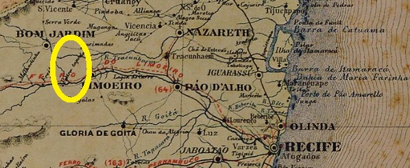
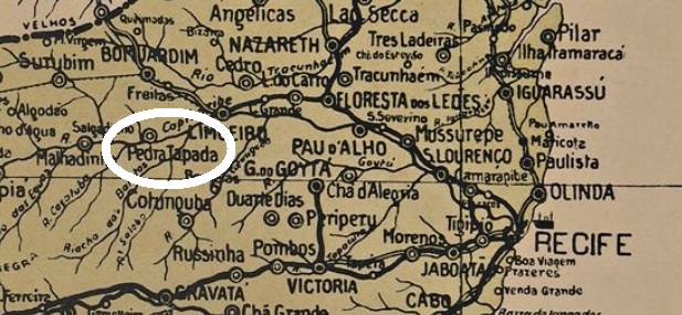
Other names: Pedra Tapada, Malhada (1938), Passira (1943)
See also Pedra Tapada (R. Koester: Carimbologia XXX)
The settlement of São José da Pedra Tapada (= of the covered stone) became as late as December 1892 a district of Limoeiro, which was located about 100 km west of the former provincial capital Recife. The place has changed its name twice since then: in December 1938 to Malhada and five years later to Passira, named after a mountain range in the area. The word from the Tupi Indian language is meant to mean arrowhead. Since December 1963, Passira has been an independent municipality.
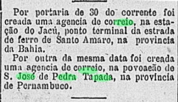
The local post office was created in May 1884, as reported by the Rio press:
Gazeta de Noticias/RJ, 31 May 1884
So far, unfortunately, no postmark of the imperial era could be found.
Arthur D. Ribeiro: Mappa do Estado de Pernambuco, 1924
Andere Namen: Pedra Tapada, Malhada (1938), Passira (1943)
Siehe auch Pedra Tapada (R. Koester: Carimbologia XXX)
Die Siedlung von São José da Pedra Tapada (= des zugedeckten Steins) wurde erst im Dezember 1892 zu einem Distrikt von Limoeiro, der gut 100 km westlich der ehemaligen Provinzhauptstadt Recife lag. Danach wechselte der Ortsname zweimal: im Dezember 1938 zu Malhada und fünf Jahre später zu Passira, genannt nach einem Gebirge der Umgebung. Das Wort aus der Tupi-Indianersprache soll Pfeilspitze bedeuten. Seit Dezember 1963 ist Passira ein eigenständiger Município.
Das örtliche Postamt wurde im Mai 1884 ins Leben gerufen, wie die Presse aus Rio berichtet:
Gazeta de Noticias/RJ, 31. Mai 1884
Bisher konnte leider kein Poststempel der Kaiserzeit gefunden werden.
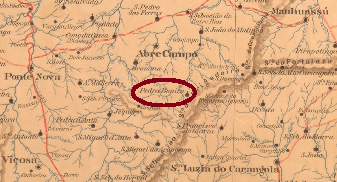
Sao José da Pedra Bonita (= of the Beautiful Stone) was a district of Abre Campo, located at the northern tip of the Serra do Brigadeiro, about 190 km east of the provincial capital Ouro Preto. In September 1923, the place name was simplified to Pedra Bonita, and since December 1995 Pedra Bonita has been an independent municipality.
As Paula Sobrinho writes in Historia Postal de Minas Gerais (Belo Horizonte, 1997), there has been a post office there since January 1884. The only postmark seen so far of the imperial period is SMG-2429a (Coll. José A. Junges): a double circle with the inscription S. JOSÉ DA PEDRA BONITA above and an ornament in cross below, which consists of four small branches. Dates inside between 1886 and 1892.
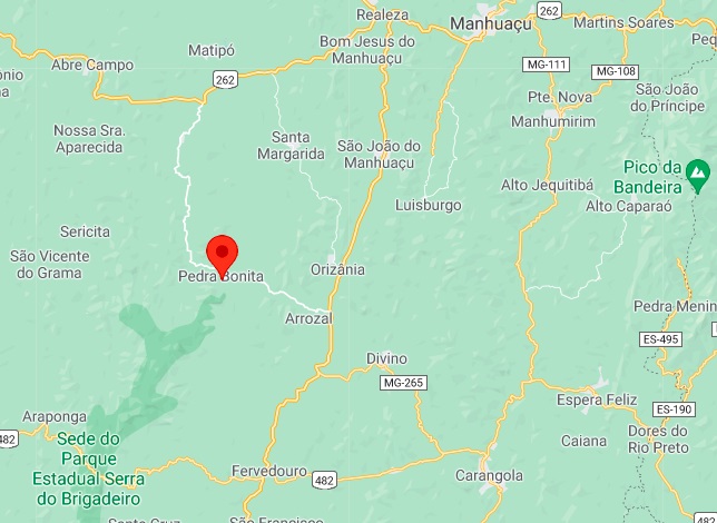
Google Maps
Anderer Name: Pedra Bonita (1923)
São José da Pedra Bonita (= des Schönen Steins) war ab Oktober 1870 ein Distrikt von Abre Campo, der an der Nordspitze der Serra do Brigadeiro lag, ca. 190 km östlich der Provinzhauptstadt Ouro Preto entfernt. Im September 1923 wurde der Ortsname zu Pedra Bonita vereinfacht, und seit Dezember 1995 ist Pedra Bonita ein eigenständiger Município.
Wie Paula Sobrinho in Historia Postal de Minas Gerais (Belo Horizonte, 1997) schreibt, gibt es dort ein Postamt seit Januar 1884. Der einzige bisher gesehene Poststempel der Kaiserzeit ist SMG-2429a (Samml. José A. Junges): ein Doppelkreis mit der Inschrift. S. JOSÉ DA PEDRA BONITA oben und einem Ornament in Kreuz unten, das aus vier kleinen Zweigen besteht. Daten in der Mitte zwischen 1886 und 1892.
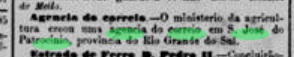
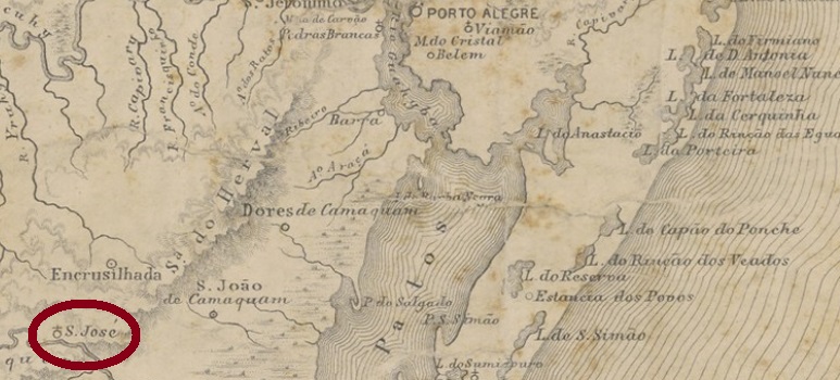
Other names: Sao José, Patrocínio, Abolição, Amaral Ferrador (1949)
The village was from May 1846 a district of Encruzilhada, located on the north bank of the river Camaquã, about 190 km southwest of the provincial capital Porto Alegre. The place changed name four more times: in March 1938 to Sao José, in December of the same year to Patrocínio, six years later to Abolição and in December 1949 to Amaral Ferrador, who has been a municipality since May 1988. The name is reminiscent of a 19th-century general who went through all wars in the region for about 30 years.
The local post office was established in April 1881, as reported by the press from Rio:
Jornal do Commercio/RJ, 23 April 1881
The oldest postmark from there is SRS-0340a (Coll. José A. Junges): a double circle with the inscription S. J. DO PATROCINIO above and an ornament in diamond form at the bottom, consisting of four small diamonds. Dates at the centre between 1887 and 1892.
Provincia de São Pedro do Rio Grande, 1877
Andere Namen: São José, Patrocínio, Abolição, Amaral Ferrador (1949)
Die Ortschaft war ab Mai 1846 ein Distrikt von Encruzilhada, der am Nordufer des Flusses Camaquã lag, ca. 190 km südwestlich der Provinzhauptstadt Porto Alegre entfernt. Der Ortsname wechselte noch viermal: im März 1938 zu São José, im Dezember desselben Jahres zu Patrocínio, sechs Jahre später zu Abolição und im Dezember 1949 zu Amaral Ferrador, der seit Mai 1988 ein eigener Município ist. Der Name erinnert an einem General des 19. Jahrhunderts, der ca. 30 Jahre lang alle Kriege im Umland durchgemacht hat.
Das örtliche Postamt entstand im April 1881, wie die Presse aus Rio berichtet:
Jornal do Commercio/RJ, 23. April 1881
Der älteste Poststempel des Orts ist SRS-0340a (Samml. José A. Junges): ein Doppelkreis mit der Inschrift S. J. DO PATROCINIO oben und einem Ornament in Raute unten, das aus vier kleinen Rauten besteht. Daten in der Mitte zwischen 1887 und 1892.
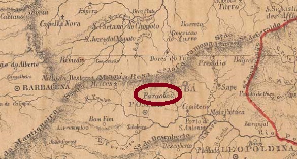
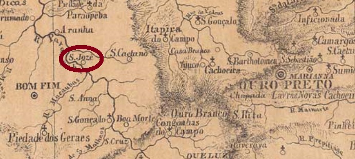
In the imperial province of Minas Gerais there were two rivers called Paraopeba, and two localities named São José do Paraopeba! See also SMG-2469.
This S. José do Paraopeba was from July 1868 a freguesia of Pomba, located on the south bank of the smaller river Paraopeba (35 km long, a tributary to the Rio Pomba) in Minas Gerais, about 200 km southeast of the provincial capital Ouro Preto. In December 1878, the place name was changed to S. José de Tocantins, probably to avoid further confusion with the place of the same name near Ouro Preto. In September 1923, the district was simply called Tocantins and received its political emancipation as a municipality in December 1948.
According to Paula Sobrinho (História Postal de Minas Gerais, Belo Horizonte, 1997), there has been a post office there since August 1866. We have each found a stamp in the imperial era with each place name and a mute cancel. SMG-2470a (Coll. José A. Junges) has a double circle with the inscription S. J. DE PARAOPEBA above. The dates inside were found for the period 1878-1883, i.e. mainly from the time when the place was already renamed. However, the year is sometimes missing.
Meanwhile, an evidently older postmark has appeared: PMG-2470a (Col. Fuad Ferreira Fo.) on a D. Pedro issue of 1866. Since it is not listed in Carimbologia S2, it is presented here:
PMG-2470a (FF) 1866ff “ex-Nacinovic”
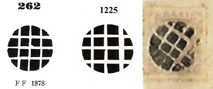
SMG-2435a (Coll. José A. Junges) has now the inscription S. JOSÉ DE TOCANTINS between circles above and below an ornament in cross, formed by four converging arrowheads. Dates inside: 1885-1895. The mute cancel was placed on a letter (Coll. José L. Fevereiro) from 1883, together with SMG-2470a. It is very similar to templates No. 262 by Paulo Ayres (Catalogo de Carimbos Brasil-Império, S. Paulo, 1937, 1942) and No. 1225 by James Dingler/Klerman W. Lopes (Mute Cancellations of the Brazil Empire/Carimbos Mudos do Brasil Império, Brazil Philatelic Association, Rio de Janeiro, 2000):
P.A. 262/BPA 1225, 1883 (Coll. José L. Fevereiro)Provincia de Minas Geraes, 1873
Aktualisierung der Druckausgabe, am 12. November 2021
In der kaiserlichen Provinz Minas Gerais gab es zwei Flüsse namens Paraopeba und zwei verschiedene Orte mit dem Namen São José do Paraopeba! Siehe auch SMG-2469.
Dieser S. José do Paraopeba war ab Juli 1868 eine Freguesia von Pomba, die am Südufer des kleineren Flusses Paraopeba (35 km lang, ein Zufluss des Rio Pomba) in Minas Gerais lag, knapp 200 km südöstlich der Provinzhauptstadt OuroPreto entfernt. Im Dezember 1878 wurde der Ortsnamen zu S. José de Tocantins geändert, wohl um weitere Verwechslungen mit dem gleichnamigen Ort bei Ouro Preto zu vermeiden. Im September 1923 hieß der Distrikt einfach Tocantins und erhielt seine politische Emanzipation als Municipio im Dezember 1948.
Laut Paula Sobrinho (História Postal de Minas Gerais, Belo Horizonte, 1997) gibt es dort ein Postamt seit August 1866. Wir haben jeweils einen Stempel in der Kaiserzeit mit jedem Ortsnamen und eine stumme Entwertung gefunden. SMG-2470a (Samml. José A. Junges) hat einen Doppelkreis mit der Inschrift S. J. DE PARAOPEBA oben. Die Daten in der Mitte wurden für den Zeitraum 1878-1883 gefunden, also überwiegend aus der Zeit, als der Ort bereits anders hieß. Allerdings fehlt ab und zu die Jahresangabe.
Inzwischen wurde ein offensichtlich älterer Stempel gefunden: PMG-2470a (Col. Fuad Ferreira Fo.) erschien auf einer D. Pedro-Ausgabe von 1866. Da er nicht im Carimbologia S2 enthalten ist, wird er hier vorgestellt:
PMG-2470a (FF) 1866ff “ex-Nacinovic”
SMG-2435a (Samml. José A. Junges) hat im Doppelkreis nun die Inschrift S. JOSÉ DE TOCANTINS oben und unten ein Ornament in Kreuz, durch vier konvergierende Pfeilspitzen gebildet. Daten in der Mitte: 1885-1895. Der stumme Stempel wurde auf einem Brief (Samml. José L. Fevereiro) aus 1883 gefunden, zusammen mit SMG-2470a. Er ähnelt stark den Vorlagen Nr. 262 von Paulo Ayres (Catálogo de Carimbos Brasil-Império, S. Paulo, 1937, 1942) und Nr. 1225 von James Dingler/Klerman W. Lopes (Mute Cancellations of the Brazil Empire/Carimbos Mudos do Brasil Império, Brazil Philatelic Association, Rio de Janeiro, 2000):
P.A. 262/BPA 1225, 1883 (Samml. José L. Fevereiro)
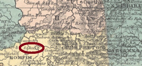
In the imperial province of Minas Gerais there were two rivers called Paraopeba, and two different localities named São José do Paraopeba! See also SMG-2470, today the municipality of Tocantins.
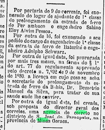
This village was since December 1873 a parish located on the east bank of the Paraopeba River, about 100 km west of the provincial capital Ouro Preto. After that, the place changed twice: in September 1923 to Itabirito and in December 1938 to Brumadinho, which is still the actual status.
Paula Sobrinho writes in Historia Postal de Minas Gerais (Belo Horizonte, 1997) that the local post office was created in November 1881. This is ratified by the Rio press:
Gazeta de Noticias/RJ, 18 November 1881
SMG-2469a (Coll. José A. Junges) has a double circle with the inscription S. JOSÉ DO PARAOPEBA above and an ornament in cross below, which consists of four branches. The dates inside were found for the period 1890-1898.
Provincia de Minas Geraes, 1873
In der kaiserlichen Provinz Minas Gerais gab es zwei Flüsse namens Paraopeba und zwei verschiedene Orte mit dem Namen São José do Paraopeba! Siehe auch SMG-2470, heute Município von Tocantins.
Diese Ortschaft war seit Dezember 1873 eine Pfarrei am Ostufer des Flusses Paraopeba, die ca. 100 km westlich der Provinzhauptstadt Ouro Preto entfernt lag. Danach wechselte der Ort noch zweimal: im September 1923 zu Itabirito und im Dezember 1938 zu Brumadinho, was der aktuelle Stand noch ist.
Paula Sobrinho schreibt in seiner Historia Postal de Minas Gerais (Belo Horizonte, 1997) dass das örtliche Postamtim November 1881 entstanden ist. Das ist auch belegt durch eine Pressemeldung aus Rio:
Gazeta de Noticias/RJ, 18. November 1881
SMG-2469a (Samml. José A. Junges) hat einen Doppelkreis mit der Inschrift S. JOSÉ DO PARAOPEBA oben und einem Ornament in Kreuz unten, das aus vier Zweigen besteht. Daten in der Mitte: 1890 bis 1898.
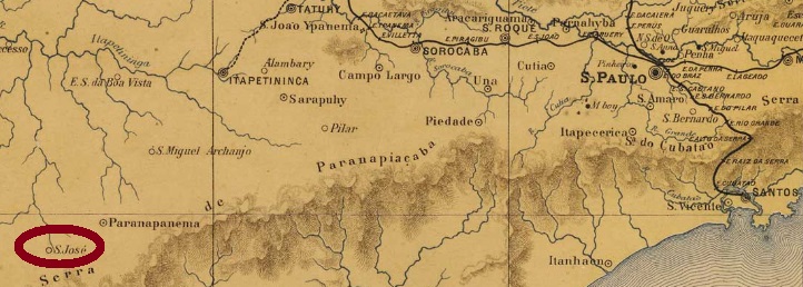
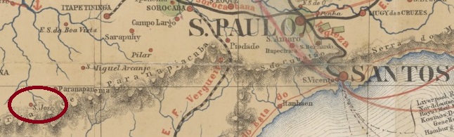
Other names: S. José, S. José de Guapiara, Guapiara (1905)
From April 1878, this village was a freguesia of Capão Bonito, about 260 km southwest of the provincial capital of São Paulo. In October 1902, it became a district called S. José do Guapiara, which three years later was renamed simply Guapiara. Since December 1948, Guapiara has been a town in own municipality. The tupi-guarani word means Valley Road.
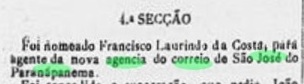
The philatelist Mario Orsi writes that there has been a post office there since June 1887. This will probably be correct, for the first employee was announced shortly afterwards in the press from S. Paulo:
Correio Paulistano, 21 August 1887
The only early cancel found so far is SSP-1175a (Coll. José A. Junges): a double circle with the inscription AGIA DE S. JOSÉ DO PARANAPANEMA above and a dot between circles below. One copy seen, dated 1896 inside.
Provincia de São Paulo, 1886
Andere Namen: S. José, S. José de Guapiara, Guapiara (1905)
Diese Ortschaft war ab April 1878 eine Freguesia bei Capão Bonito, die ca. 260 km südwestlich der Provinzhauptstadt São Paulo entfernt lag. Im Oktober 1902 wurde daraus ein Distrikt namens S. José do Guapiara, der drei Jahre später lediglich Guapiara hieß. Seit Dezember 1948 ist Guapiara eine Stadt im eigenen Município. Das Wort aus der Tupi-Guarani-Sprache bedeutet Weg zum Tal.
Der Philatelist Mario Orsi schreibt, es gibt dort ein Postamt seit Juni 1887. Das wird wohl stimmen, den der erste Angestellte wurde kurz darauf in der Presse aus S. Paulo angekündigt:
Correio Paulistano, 21. August 1887
Der einzige bisher gefundene Stempel ist SSP-1175a (Samml. José A. Junges): ein Doppelkreis mit der Inschrift AGIA DE S. JOSÉ DO PARANAPANEMA oben und einem Punkt zwischen den Kreisen unten. Ein Exemplar vorhanden, datiert 1896 in der Mitte.
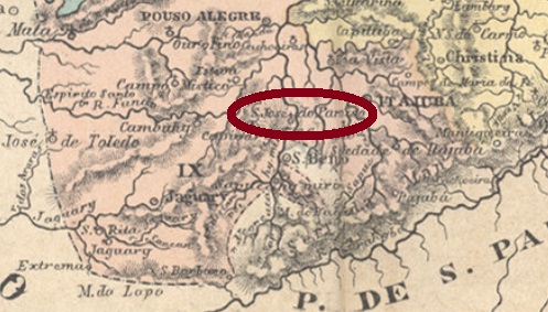
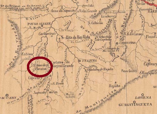
Other names: Campo do Lima (1826), São José da Ventania (1827), São José das Formigas (1831), Paraiso (1850), Paraisópolis (1914)
The history of this village began around 1826 with the settlement of Campo do Lima (Lima’s Field), which was located on the west bank of the Sapucahy-Mirim River, about 470 km southwest of the provincial capital Ouro Preto. There were several renamings: to São José da Ventania, São José das Formigas, and São José do Paraíso, as the parish in the municipality of Itajubá was called in 1850. In November 1867, the municipality was elevated to a villa, but less than a year later it was demoted to a district of Pouso Alegre. In July 1872, S. José do Paraíso became a villa in own municipality, which has been called Paraisópolis since September 1914.
As Paula Sobrinho reports in Historia Postal de Minas Gerais (Belo Horizonte, 1997), there has been a post office there since May 1872. Two postmarks in the Empire could be found. SMG-2465a (Coll. José A. Junges) is the first one: a frame cancel with the inscription S. JOSÉ/ DO /PARAISO, without date. Found on numeral editions from 1850, which means a rather late use of these stamps. It was followed by SMG-2465b (Coll. José A. Junges): a double circle with the inscriptions S. JOSÉ DO PARAIZO above and (MINAS) below. Dates inside between 1888 and 1891.
Provinica de Minas Geraes, 1873
Andere Namen: Campo do Lima (1826), São José da Ventania (1827), São José das Formigas (1831), Paraiso (1850), Paraisópolis (1914)
Die Geschichte dieser Ortschaft fing ca. 1826 mit der Siedlung Campo do Lima (Limas Feld) an, die am Westufer des Flusses Sapucahy-Mirim lag, ca. 470 km südwestlich der Provinzhauptstadt Ouro Preto entfernt. Danach gab es mehrere Umbenennungen: zu São José da Ventania, São José das Formigas und São José do Paraíso, wie die Pfarrei im Município von Itajubá 1850 hieß. Im November 1867 wurde die Gemeinde zur Villa erhoben, aber knapp ein Jahr später wieder zum Distrikt von Pouso Alegre degradiert. Im Juli 1872 wurde S.José do Paraíso wieder eine Villa im eigenen Município, die seit September 1914 Paraisópolis heißt.
Wie Paula Sobrinho in Historia Postal de Minas Gerais (Belo Horizonte, 1997) berichtet, gibt es dort ein Postamt seit Mai 1872. Zwei Poststempel im Kaiserreich konnten hierzu gefunden werden. SMG-2465a (Samml. José A. Junges) ist der erste: ein Rahmenstempel mit der Inschrift S. JOSÉ / DO /PARAISO, ohne Datum. Gefunden auf Ziffern-Ausgaben von 1850, was eine ziemlich späte Verwendung dieser Marken bedeutet. Ihm folgte SMG-2465b (Samml. José A. Junges): ein Doppelkreis mit den Inschriften S. JOSÉ DO PARAIZO oben und (MINAS) unten. Daten in der Mitte von 1888-1891.
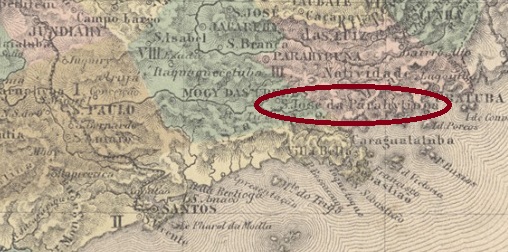
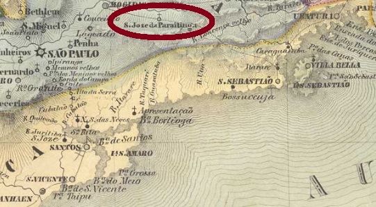
From February 1838, this place was a freguesia of Mogy das Cruzes, which was located on the upper reaches of the Rio Tietê, about 100 km west of the provincial capital of São Paulo. In March 1857 it rose to a villa, which changed its name to Salesopolis in November 1905 and was elevated to a town the following year. The name is reminiscent of the lawyer Manuel Ferraz de Campos Sales (1841-1913), the Brazilian president from 1898 to 1902, who was born in Campinas.
As can be read in the Imperial Mail Register (Tabella das Agencias do Correio do Imperio) from 1885, there is a post office there since 1872. So far only one postmark of the imperial period has been found. SSP-1170a (Coll. José A. Junges) is a French-ype: a double circle with the inscription S. J. DO PARAHYTINGA above and the typical star between brackets below. The date inside shows the year 1888.
Villiers de l’Ile Adam: Carta (…) da Provincia de São Paulo, 1847
Anderer Name: Salesópolis (1905)
Dieser Ort war ab Februar 1838 eine Freguesia von Mogy das Cruzes, die am Oberlauf des Rio Tietê, gut 100 km westlich der Provinzhauptstadt São Paulo lag. Im März 1857 stieg er zu einer Villa auf, die im November 1905 den Namen zu Salesópolis wechselte und im darauffolgenden Jahr zur Stadt erhoben wurde. Der Name erinnert an den Juristen Manuel Ferraz de Campos Sales (1841-1913), den in Campinas geborenen brasilianischen Präsidenten von 1898 bis 1902.
Wie im Verzeichnis der kaiserlichen Postämter (Tabella das Agencias do Correio do Imperio) aus 1885 zu lesen ist, gibt es dort ein Postamt seit 1872. Bisher wurde nur ein Poststempel der Kaiserzeit gefunden. SSP-1170a (Samml. José A. Junges) ist ein Französischer-Typ: ein Doppelkreis mit der Inschrift S. J. DO PARAHYTINGA oben und dem typischen Stern zwischen Klammern unten. Das Datum in der Mitte zeigt das Jahr 1888.
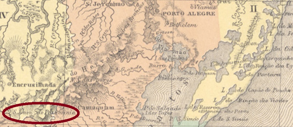
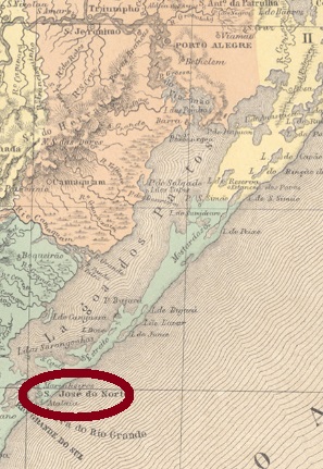
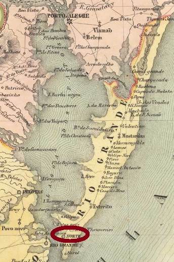
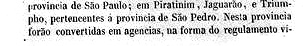
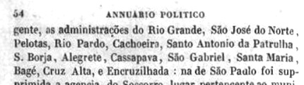
From April 1820, this village was a freguesia of Rio Grande, which was elevated to a villa in October 1831 and was located about 330 km south of the provincial capital Porto Alegre. The name do Norte (“from the north”) refers either to the location north of the mouth of the Lagoa dos Patos, or perhaps in contrast to another place of the same name, which was further south.
Here, too, two dates of origin for the local post office were found: once before, once after the Farroupilha Revolution (1835-1845). It follows that the postal service was temporarily paralyzed during the uprising. According to Nova Monteiro, the post office was first created in October 1831. The Imperial Mail Register (Tabella das Agencias do Correio do Imperio) from 1885 lists the agency from 1847, but this is probably the installing year, since the official creation to open was announced a year earlier:
Annuario Politico, Historico e Estatistico do Brazil, 1846
The oldest cancel is SRS-0335a, which was thought to be from Porto Alegre, for post towards north (Norte). Reinhold Koester nevertheless wrote in Porto Alegre and its cancels until the end of the imperial period (in Brazil, 140 years of postage stamps, ArGe Brazil, 1983) that it was also used on mail from north to Porto Alegre, and thus would be a transit cancel of São José do Norte. The cancel was used until about 1835 and is presented in the RHM catalogue under P-RS-06:
SRS-0335a (RHM P-RS-06)
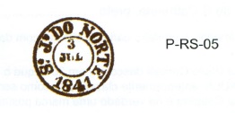
It was followed by SRS-0335b, which is also found in red and brown. Sometimes the year is missing, and this cancel is also shown by RHM:
SRS-0335b (RHM P-RS-05), 1841-1844ff
The last cancel, SRS-0335c (Coll. José A. Junges) is a double circle with the inscription S. JOSÉ DO NORTE above. It also appears in blue and its dates in the middle were found for the period 1876-1886.
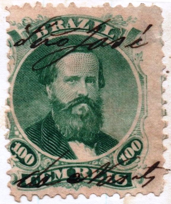
Between SRS-0335b and -0335c manuscript cancellations were also common, as this image from a letter of 1873 shows:
1873 (Coll. José A. Junges)Villiers de l’Ile Adam: Carta (…) da Provincia de São Pedro do Sul, 1847
Anderer Name: Norte
Diese Ortschaft war ab April 1820 eine Freguesia von Rio Grande, die bereits im Oktober 1831 zur Villa erhoben wurde, und ca. 330 km südlich der Provinzhauptstadt Porto Alegre lag. Der Name do Norte („aus dem Norden“) bezieht sich entweder aus der Lage nördlich der Mündung der Lagoa dos Patos, oder vielleicht auch in Unterschied zu einem anderen Ort gleichen Namens, der weiter südlich lag.
Auch hier wurden zwei Entstehungsdaten fürs örtliche Postamt gefunden: einmal vor, einmal nach der Farroupilha-Revolution (1835-1845). Daraus folgt, dass der Postbetrieb zeitweise während des Aufstands lahmgelegt wurde. Laut Nova Monteiro entstand das Postamt erstmals im Oktober 1831. Das Verzeichnis der kaiserlichen Postämter(Tabella das Agencias do Correio do Imperio) aus 1885 listet die Agentur ab 1847, das dürfte aber der Zeitpunkt der Inbetriebnahme sein, da die offizielle Anweisung zur Eröffnung ein Jahr zuvor veröffentlicht wurde:
Annuario Politico, Historico e Estatistico do Brazil, 1846
Der älteste Stempel ist SRS-0335a, von dem man dachte, er wäre aus Porto Alegre und für Post nach Norden (Norte) bestimmt. Reinhold Koester schrieb dennoch in Porto Alegre und seine Stempel bis zum Ende der Kaiserzeit (in Brasilien, 140 Jahre Briefmarken, ArGe Brasilien, 1983), dass der Stempel auch auf Post aus Norden nach Porto Alegre verwendet wurde, und dadurch ein Transitstempel von São José do Norte wäre. Der Stempel wurde bis ca. 1835 gebraucht und wird im RHM-Katalog unter P-RS-06 vorgestellt:
SRS-0335a (RHM P-RS-06)
Ihm folgte SRS-0335b, der auch in rot und braun vorkommt und manchmal die Jahresangabe nicht bringt. Ebenfalls im RHM abgebildet:
SRS-0335b (RHM P-RS-05), 1841-1844ff
Der letzte Stempel, SRS-0335c (Samml. José A. Junges) ist ein Doppelkreis mit der Inschrift S. JOSÉ DO NORTE oben. Er kommt auch in blau vor und seine Daten in der Mitte wurden für den Zeitraum 1876-1886 gefunden.
Zwischen SRS-0335b und -0335c wurde offenbar auch per Hand entwertet, wie diese Abbildung aus einem Brief aus 1873 zeigt: