Bellegard-Niemeyer: Carta Corographica da Provincia do Rio de Janeiro, 1867
Another name: São José das Rolinhas
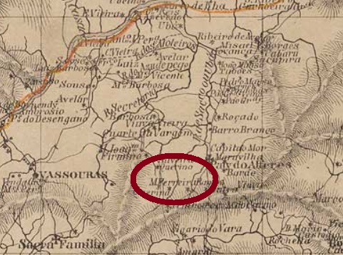
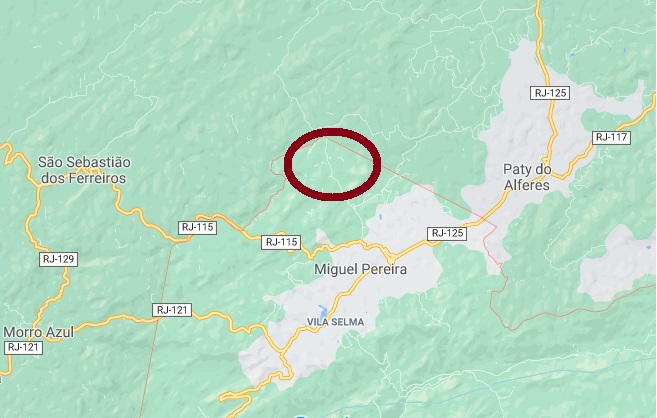
This village was from December 1864 a small settlement in the freguesia of S. Sebastião dos Ferreiros in the municipality of Vassouras, which was located on the hillside, about 120 km north of the imperial capital Rio de Janeiro. And it remained so until December 1943, when the political emancipation of Miguel Pereira as Municipio took place. Today it is a rural suburb of this town, now called S. José das Rolinhas, a peaceful tourist destination.
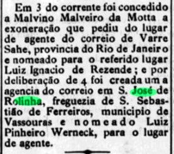
The local post office was established in February 1887, as can be read in the Rio press:
O Fluminense, 9 February 1887
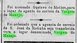
However, eight months later this agency has moved further north to Vargem do Manejo:
Novidades, 8 October 1887
No postmark of the imperial era has been found so far. This cancel must be a great rarity, given that the agency was small – and had a very short operating time.
Google Maps
Anderer Name: São José das Rolinhas
Diese Ortschaft war ab Dezember 1864 eine kleine Siedlung der Freguesia von S. Sebastião dos Ferreiros im Município von Vassouras, die am Berghang, gut 120 km nördlich der kaiserlichen Hauptstadt Rio de Janeiro entfernt lag. Und so blieb es bis Dezember 1943, als die politische Emanzipation von Miguel Pereira als Município stattfand. Heute ist es ein ländlicher Vorort dieses Städtchens, der nun S. José das Rolinhas heißt und vom Tourismus lebt.
Das örtliche Postamt entstand im Februar 1887, wie aus der Rio-Presse hervorgeht:
O Fluminense, 9. Februar 1887
Allerdings wurde diese Agentur acht Monate später weiter nördlich nach Vargem do Manejo verlegt:
Novidades, 8. Oktober 1887
Kein Poststempel der Kaiserzeit wurde bisher gefunden. Dieser Stempel muss eine große Seltenheit sein, da die Agentur sein klein war – und eine sehr kurze Betriebszeit hatte.
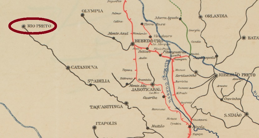
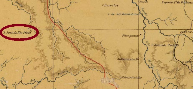
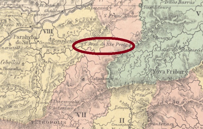
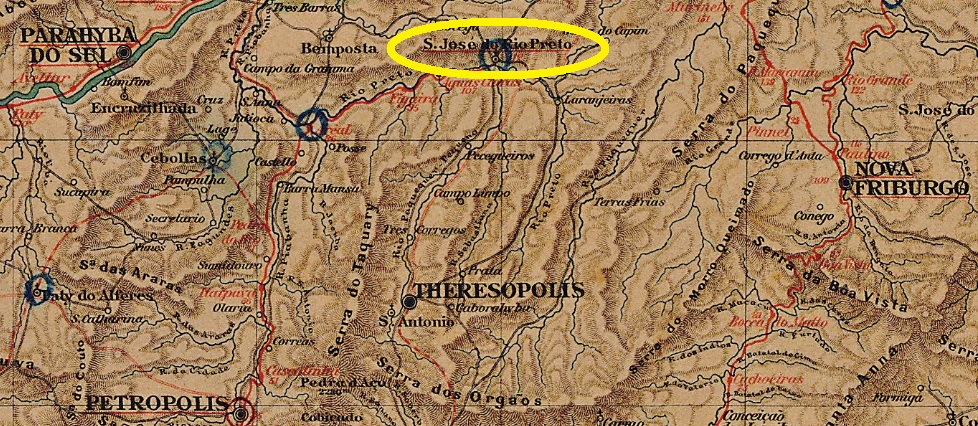
This village was from March 1879 a district in the municipality of Jaboticabal, which was located directly on the Rio Preto, about 440 km northwest of the provincial capital of São Paulo. In July 1894, it ascended to a Município, which was simply called Rio Preto between 1906 and 1944, before the original name returned.
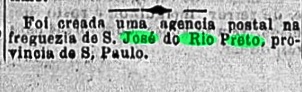
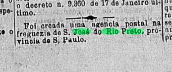
As the philatelist Mario Celso Orsi Jr. found out, the local post office was established in March 1885, which is confirmed by the Rio press:
Gazeta de Noticias, 18 March 1885
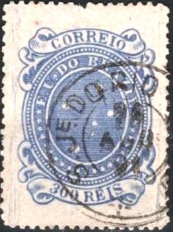
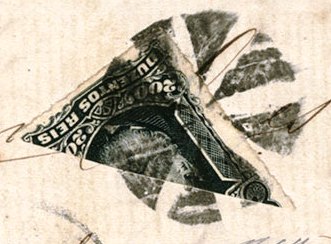
The only imperial postmark seen so far is SSP-1185a (Coll. Fuad Ferreira Fo.): a double circle with the inscription S. JOSÉ DO R. PRETO above and (S. PAULO) below. A single copy was found, dated 1887 inside.
SSP-1185b (coll. Mário Celso Orsi Jr.) also appeared at the beginning of the Republic:
SSP-1185b (MO) 1891-1897J. M. Ribeiro Lisboa: Provincia de São Paulo, 1884
Textaktualisierung am 25.12.2024
Anderer Name: Rio Preto
Diese Ortschaft war ab März 1879 ein Distrikt im Município von Jaboticabal, der direkt am Rio Preto lag, gut 440 km nordwestlich der Provinzhauptstadt São Paulo entfernt. Im Juli 1894 steig sie zum Município auf, der zwischen 1906 und 1944 einfach Rio Preto hieß, bevor der ursprüngliche Ortsname zurückkehrte.
Wie der Philatelist Mario Celso Orsi Jr. ermittelt hat, entstand das örtliche Postamt im März 1885, was durch die Presse aus Rio bestätigt wird:
Gazeta de Noticias, 18. März 1885
Der einzige bisher gesehene Poststempel der Kaiserzeit ist SSP-1185a (Samml. Fuad Ferreira Fo.): ein Doppelkreis mit der Inschrift S. JOSÉ DO R. PRETO oben und (S. PAULO) unten. Ein Exemplar gefunden, datiert 1887 in der Mitte.
Am Anfang der Republik erschien auch SSP-1185b (Samml. Mário Celso Orsi Jr.):
Other names: São José da Serra, São José, Paraúna, São José do Vale do Rio Preto (1987)
See also Rio Preto (SRJ-0853)
This Rio Preto (= Black River) emerges from the mountains of the same name in the north of the province of Rio de Janeiro. From November 1815, the village of Rio Preto was a freguesia of Niteroi, about 130 km north of the colonial capital Rio de Janeiro. The freguesia went from 1833 as a district to Parahyba do Sul and from May 1892 to Petropolis. Since then, the place changed its name three times: in March 1938 to São José, in December 1943 to Paraúna, and in June 1947 to the district of São José do Rio Preto. Since December 1987, it has been the municipality of S. José do Vale do Rio Preto.
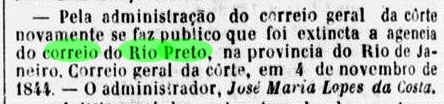
The local post office opened twice: first, about 1839, and it was closed in November 1844, as can be read in the press from Rio:
Jornal do Commercio, 06 November 1844
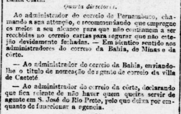
As Paulo Novaes (agenciaspostais.com.br) informs, this post office was created for the second time in November 1860. However, it is questionable whether the operation started immediately, for at the beginning of 1862 a postal clerk was still sought for this agency:
Expediente do Ministerio da Agricultura, 21 January 1862
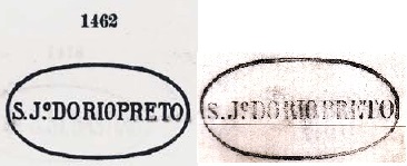
Two town and two mute cancels in the imperial period were found. SRJ-1460a was in circulation from about 1860 to at least 1876 and was already depicted by Paulo Ayres (Catalogo de Carimbos Brasil-Império, S. Paulo, 1937, 1942) under No. 1462. This figure, however, has a false letter: the original e became an o, as if an abbreviation for Sao João was instead of José:
P.A. 1462 – SRJ-1460a recte
It was followed by SRJ-1460b (Coll. José A. Junges): a double circle with the inscription S. J. DO RIO PRETO above. The dates inside were found so far for the period 1879-1899.
The first mute cancel was found on a letter from 1879 and circulated until at least 1882:
(Coll. Paulo R. Risi) 1879-1882
The second one was seen on a letter from 1880:
(EB) 1880Almanak Laemmert, 1892
Andere Namen: São José da Serra, São José, Paraúna, São José do Vale do Rio Preto (1987)
Siehe auch Rio Preto (SRJ-0853)
Dieser Rio Preto (= Schwarzer Fluss) entspringt dem gleichnamigen Gebirge im Norden der Provinz Rio de Janeiro. São José do Rio Preto war ab November 1815 eine Freguesia von Niteroi, die ca. 130 km nördlich der kolonialen Hauptstadt Rio de Janeiro lag. Die Freguesia ging ab 1833 als Distrikt zu Parahyba do Sul und ab Mai 1892 zu Petrópolis. Danach wechselte der Ortsname dreimal: im März 1938 zu São José, im Dezember 1943 zu Paraúna und im Juni 1947 zurück zu São José do Rio Preto. Seit Dezember 1987 ist es der Município von S. José do Vale do Rio Preto.
Das örtliche Postamt eröffnete zweimal: erstens ca. 1839, und es wurde im November 1844 geschlossen, wie man in der Presse aus Rio lesen kann:
Jornal do Commercio, 06. November 1844
Wie Paulo Novaes (agenciaspostais.com.br) informiert, entstand dieses Postamt zum zweiten Mal im November 1860. Allerdings ist es fraglich, ob der Betrieb gleich aufgenommen wurde, zumal noch am Anfang 1862 ein Postangestellter für diese Agentur gesucht war:
Expediente do Ministerio da Agricultura, 21. Januar 1862
Zwei Ortsstempel und zwei stumme Entwertungen der Kaiserzeit wurden gefunden. SRJ-1460a war von ca. 1860 bis mindestens 1876 im Umlauf und wurde zwar bereits durch Paulo Ayres (Catálogo de Carimbos Brasil-Império, S. Paulo, 1937, 1942) unter Nr. 1462 abgebildet. Diese Abbildung hat aber einen falschen Buchstaben: aus dem ursprünglichen e wurde ein o, als wäre eine Abkürzung für São João statt José:
P.A. 1462 – SRJ-1460a recte
Ihm folgte SRJ-1460b (Samml. José A. Junges): ein Doppelkreis mit der Inschrift S. J. DO RIO PRETO oben. Die Daten in der Mitte wurden bisher für den Zeitraum 1879-1899 gefunden.
Der erste stumme Stempel wurde auf einem Brief aus 1879 gefunden und wurde zumindest bis 1882 verwendet:
From May 1850, this village was a district of Santo Antonio do Parahybuna (now Juiz de Fora), located about 260 km south of the provincial capital Ouro Preto. Since then, the place name has changed three times: in September 1923 to Torreão, in September 1927 to São José das Três Ilhas, and four years later to the simplified Três Ilhas. It has been a district of Belmiro Braga since December 1962. The name (=Three Islands) is somewhat enigmatic, as there is no river or island in the area.
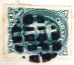
According to Paula Sobrinho (História Postal de Minas Gerais, Belo Horizonte, 1997), there has been a post office there since June 1879. A place cancel was found. SMG-2480a (Coll. Fuad Ferreira Fo.) has a double circle with the inscription. S. JOSÉ DO RIO PRETO above and an ornament in cross below consisting of four converging arrows. Dates inside from 1885 to 1902.
Provincia de Minas Geraes, 1873
Andere Namen: São José, Torreão, Três Ilhas (1938)
Diese Ortschaft war ab Mai 1850 ein Distrikt von Santo Antonio do Parahybuna (heute: Juiz de Fora), der ca. 260 km südlich der Provinzhauptstad Ouro Preto entfernt lag. Seitdem wechselte der Ortsname dreimal: im September 1923 zu Torreão, im September 1927 zu São José das Três Ilhas, und vier Jahre später zum vereinfachten Três Ilhas. Seit Dezember 1962 ist Três Ilhas ein Distrikt von Belmiro Braga. Der Name (Drei Insel) ist etwas rätselhaft, da weder ein Fluss noch Insel in der Umgebung vorhanden sind.
Laut Paula Sobrinho (História Postal de Minas Gerais, Belo Horizonte, 1997) gibt es dort ein Postamt seit Juni 1879. Ein Ortsstempel wurde gefunden. SMG-2480a (Samml. Fuad Ferreira Fo.) hat einen Doppelkreis mit der Inschrift. S. JOSÉ DO RIO PRETO oben und ein Ornament in Kreuz unten, das aus vier konvergierenden Pfeilen besteht. Daten in der Mitte von 1885 bis 1902.
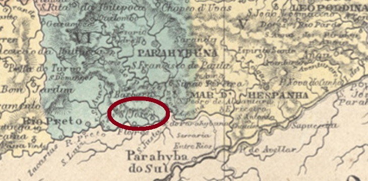
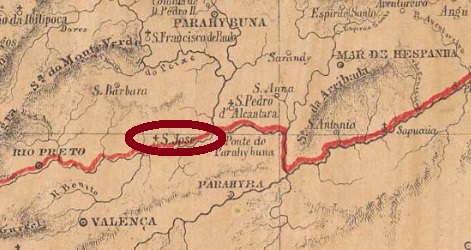
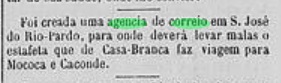
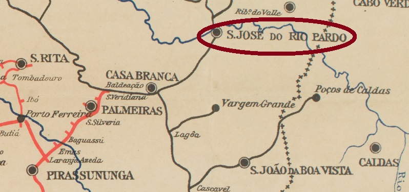
From April 1874, this village was a freguesia near Casa Branca, located on the southern bank of the Rio Pardo, about 260 km north of the provincial capital São Paulo. In May 1877, it became a district of Caconde, which in April 1880 changed to the municipality of Casa Branca. Since March 1885, the town has been a villa in the municipality of Rio Pardo, and became a town in May 1891.
The local post office was established in July 1879, as can be read in the press in São Paulo:
Jornal da Tarde, 1 August 1879
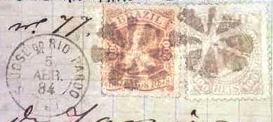
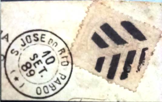
One local and one mute cancel were found. SSP-1180a (Coll. Fuad Ferreira Fo.) is a French type, with the inscription S. JOSÉ DO RIO PARDO above and the typical star between brackets below. The dates inside were found for the period 1884-1890. The mute cancellation (Coll. Fuad Ferreira Fo.) was found on a fragment from 1884, in connection with SSP-1180:
SSP-1180a (Coll. Fuad Ferreira Fo.) 1884
After the opening of the train station in 1887 with the construction of a line branch from Casa Branca, a cancellation for itinerant railway mail was also used. As this postmark has not yet been seen in Carimbologia S2, SSP-1181a is shown here:
SSP-1181a (Coll. Fuad Ferreira Fo.) 1889
In the meantime, another mute cancel from this locality has also shown up, which was to be used at the end of the Empire in connection with SSP-1180a. However, caution is advised here, as such a late date and a hitherto unknown design are very unusual:
1889 (Coll. Fuad Ferreira Fo.)Companhia Paulista
Aktualisierung der Printausgabe, am 19. Dezember 2021
Diese Ortschaft war ab April 1874 eine Freguesia bei Casa Branca, die am Südufer des Rio Pardo lag, knapp 260 km nördlich der Provinzhauptstadt São Paulo entfernt. Im Mai 1877 wurde sie ein Distrikt von Caconde, der im April 1880 zum Município von Casa Branca wechselte. Seit März 1885 ist São José do Rio Pardo eine Villa im eigenen Município, die sich seit Mai 1891 eine Stadt nennen darf.
Das örtliche Postamt ist im Juli 1879 entstanden, wie aus der Presse im São Paulo hervorgeht:
Jornal da Tarde, 1. August 1879
Ein Orts- und ein stummer Stempel wurden gefunden. SSP-1180a (Samml. Fuad Ferreira Fo.) ist ein Französischer-Typ, mit der Inschrift S. JOSÉ DO RIO PARDO oben und dem typischen Stern zwischen Klammern unten. Die Daten in der Mitte wurden für den Zeitraum 1884-1890 gefunden. Der stumme Stempel (Samml. Fuad Ferreira Fo.) wurde auf einem Fragment aus 1884 gefunden, in Verbindung mit SSP-1180:
SSP-1180a (Samml. Fuad Ferreira Fo.) 1884
Nach der Eröffnung des Bahnhofs im Jahr 1887 durch den Bau einer Linienabzweigung von Casa Branca aus wurde auch eine Abstempelung für die ambulante Bahnpost verwendet. Da dieser Poststempel in Carimbologia S2 noch nicht zu sehen war, wird SSP-1181a hier gezeigt:
SSP-1181a (Samml. Fuad Ferreira Fo.) 1889
Inzwischen ist auch ein weiterer stummer Stempel aus dieser Ortschaft aufgetaucht, der am Ende des Kaiserreichs in Verbindung mit SSP-1180a verwendet werden sollte. Allerdings ist hier Vorsicht geboten, da solch ein spätes Datum und auch ein bisher unbekanntes Muster sehr unüblich sind:
José Ribeiro Lisboa: Mappa da Provincia de São Paulo, 1884
Other names: Nuretama (1944), Campos Novos Paulista (1948)
See also Campos Novos do Paranapanema (R. Koester: Carimbologia VIII)
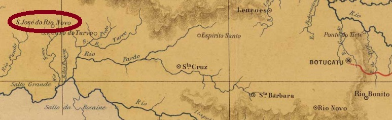
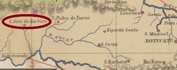
In the imperial province of São Paulo, there were two others that bring a risk of confusion with this village (SSP-1178): Rio Novo (RSP-1125) and São José do Paranapanema (SSP-1175). This São José do Rio Novo was a settlement on the eastern bank of the Novo River, a tributary of the Paranapanema – located about 400 km west of the provincial capital São Paulo. In April 1880, it became a district of Santa Cruz do Rio Pardo, bearing the long name of São José do Rio Novo de Campos Novos do Paranapanema. In March 1885, it became a villa in his own municipality and in December 1906 a town. After that, the municipality must have fared so badly economically that in November 1944 it was degraded to a district called Nuretama in the municipality of Ibirarema. But four years later, in December 1948, it rose again – to the still current municipality of Campos Novos Paulista.
The local post office was established in April 1881, as can be read from the press in São Paulo:
Jornal da Tarde, April 9, 1881
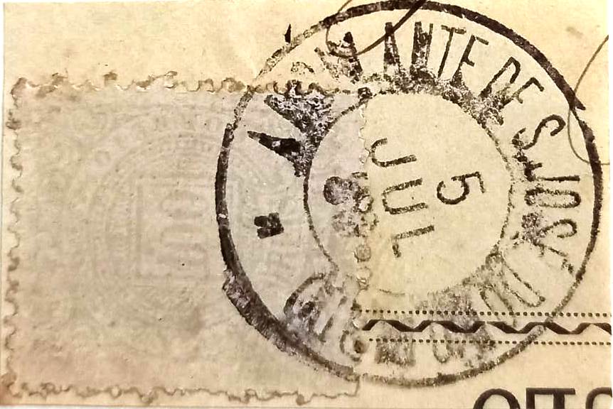
A cancel of the imperial period was found, apparently a French-type: SSP-1178a (Coll. José A. Junges) has a double circle with the inscription S. JOSÉ DO RIO NOVO above and apparently a star between brackets below. Dates inside from 1889 to 1896. For cancels with CAMPOS NOVOS DO PARANAPANEMA see Koester, Carimbologia VIII.
Provincia de São Paulo, 1886
Andere Namen: Nuretama (1944), Campos Novos Paulista (1948)
Siehe auch Campos Novos do Paranapanema (R. Koester: Carimbologia VIII)
In der kaiserlichen Provinz São Paulo gab es – außer dieser Ortschaft – zwei weitere, die durch ihre Namen Verwechslungsgefahr damit bringen: Rio Novo (RSP-1125) und São José do Paranapanema (SSP-1175). Dieser São José do Rio Novo war eine Siedlung am Ostufer des Rio Novo – ein Zufluss des Paranapanema – die gut 400 km westlich der Provinzhauptstadt São Paulo entfernt lag. Im April 1880 wurde der Ort ein Distrikt von Santa Cruz do Rio Pardo, unter dem langen Namen São José do Rio Novo de Campos Novos do Paranapanema. Im März 1885 wurde er eine Villa im eigenen Município und im Dezember 1906 eine Stadt. Danach muss es der Gemeinde wirtschaftlich so schlecht ergangen sein, dass sie im November 1944 zu einem Distrikt namens Nuretama im Município von Ibirarema wurde. Aber vier Jahre später, im Dezember 1948, stieg sie wieder auf – zum noch aktuellen Município von Campos Novos Paulista.
Das örtliche Postamt entstand im April 1881, wie aus der Presse in São Paulo entnommen werden kann:
Jornal da Tarde, 09.04.1881
Ein Stempel der Kaiserzeit war zu finden, scheinbar ein Französischer-Typ: SSP-1178a (Samml. José A. Junges) hat einen Doppelkreis mit der Inschrift S. JOSÉ DO RIO NOVO oben und – wie es aussieht – einen Stern zwischen Klammern unten. Daten in der Mitte: 1889-1896. Für Stempel mit CAMPOS NOVOS DO PARANAPANEMA siehe Koester, Carimbologia VIII.
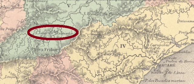
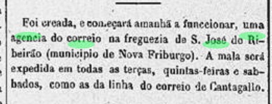
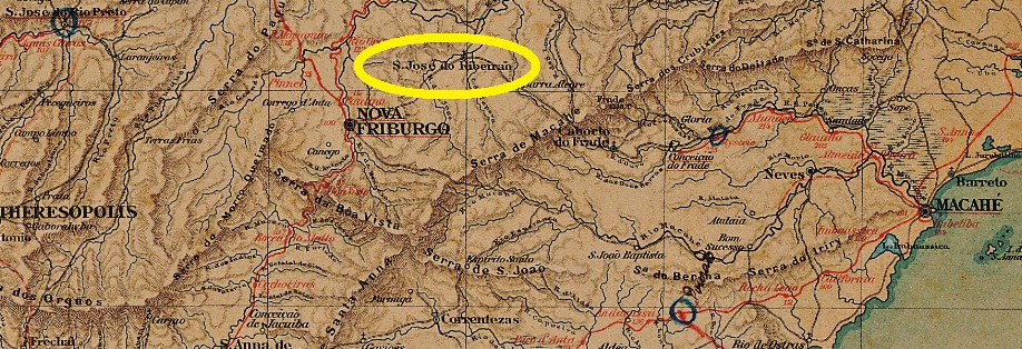
From May 1850, this village was a freguesia of Nova Friburgo, located about 200 km northeast of the imperial capital Rio de Janeiro. In December 1892, it became a district of Bom Jardim. After that, the place name changed twice. In December 1938 to Ribeirão and five years later to Paraim, before the original name finally returned in October 1949.
In the Imperial Mail Register (Tabella das Agencias do Correio do Imperio) of 1885, the local post office is listed from 1877, but apparently the operation only began the following year, as can be read in the Rio press:
Diario do Rio de Janeiro, 18 January 1878
Three early postmarks from there are known. SRJ-1455a is the first one, as registered by Paulo Ayres (Catalogo de Carimbos Brasil-Império, S. Paulo, 1937, 1942) under No. 1467:
SRJ-1455a (P. Ayres 1467) 1877ff-1884ff
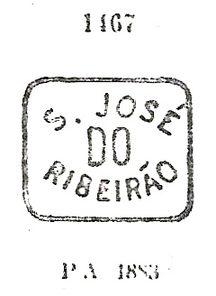
It was followed by SRJ-1455b (Coll. José A. Junges): a double circle with the inscription S. JOSÉ DO RIBEIRĀO above and an ornament in diamond form at the bottom, consisting of four small diamonds. Dates inside from ca.1887 to 1890. The last cancel will already be Republican: SRJ-1455c (image from the Internet) is also a double circle. The inscription above is now S. JE do RIBEIRÃO, there is an ornament in cross below. Dated 1896-1897 inside.
Almanak Laemmert, 1892
Andere Namen: Ribeirão, Paraim
Diese Ortschaft war ab Mai 1850 eine Freguesia von Nova Friburgo, die knapp 200 km nordöstlich der kaiserlichen Hauptstadt Rio de Janeiro lag. Im Dezember 1892 wurde sie ein Distrikt von Bom Jardim. Danach wechselte der Ortsname zweimal. Im Dezember 1938 zu Ribeirão und fünf Jahre später zu Paraim, bevor der ursprüngliche Name im Oktober 1949 definitiv zurückkehrte.
Ihm folgte SRJ-1455b (Samml. José A. Junges): ein Doppelkreis mit der Inschrift S. JOSÉ DO RIBEIRĀO oben und einem Ornament in Raute unten, das aus vier kleinen Rauten besteht. Daten in der Mitte von 1887 bis 1890. Der letzte Stempel wird bereits republikanisch sein: SRJ-1455c (Abb. aus dem Internet) ist auch ein Doppelkreis. Die Inschrift oben lautet nun S. JE do RIBEIRÃO, unten sieht man ein Ornament in Kreuz. Datiert 1896-1897 in der Mitte.
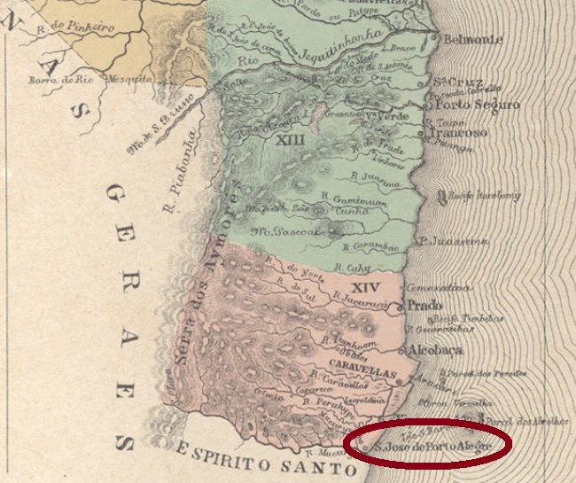
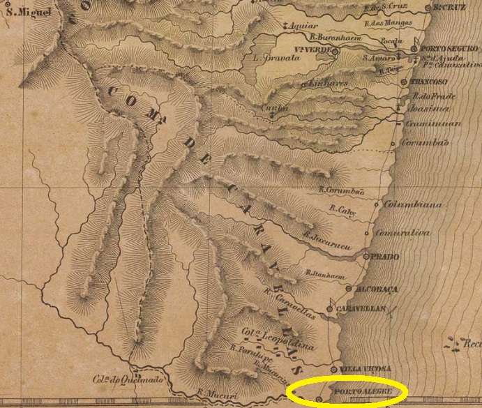
This village was an old freguesia on the beach of Viçosa, which rose to a villa already in October 1769, and was located north of the mouth of the Mucury River, 900 km south of the former colonial capital Salvador da Bahia. In January 1931, the place name was changed to Mucury, now written Mucuri.
Three different dates were found for the creation of the local postal agency. The oldest of these would be July 1855, as Aureo G. Santos reports in Agências de Correio Criadas e Suprimidas 1851, 1855, 1856 e 1857 (in Brasil Filatélico 181, Rio de Janeiro, 1977):
Aureo Santos (op. cit.)
Nova Monteiro lists the post office in Administrações e Agencias Postaes do Brasil Imperio (in Brasil Filatelico/RJ, 1934-5; Reprint SPP 1994-1999) of December 1855), and the Imperial Mail Register (Tabella das Agencias do Correio do Imperio) of 1885 writes the year 1867. Apparently the post office was closed there at least once.
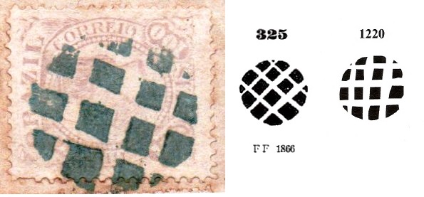
A local cancel and a mute cancellation were found, both from near the end of the Empire. SBA-0625b (Coll. José A. Junges) has a double circle with the inscription S. J. DE PORTO ALEGRE above. The dates inside vary from 1881 until 1883. The mute cancel was found on a fragment from 1883 and bears great resemblance to cancel No.325 by Paulo Ayres (Catalogo de Carimbos Brasil-Império, S. Paulo, 1937, 1942), as well as to cancel No. 1220 by J. Dingler and K. W. Lopes (Mute Cancellations of the Brazil Empire / Carimbos Mudos do Brasil Império, Brazil Philatelic Association, Rio de Janeiro, 2000):
1883 (Coll. José A. Junges) – P. Ayres 325 – BPA 1220Villiers de l’Ile Adam: Carta (…) da Provincia da Bahia, 1848
Andere Namen: Porto Alegre, Mucury
Diese Ortschaft war eine alte Freguesia am Strand von Viçosa, die bereits in der Kolonialzeit, im Oktober 1769, zur Villa erhoben wurde und nördlich der Mündung des Flusses Mucury lag, 900 km südlich der ehemaligen Kolonialhauptstadt Salvador da Bahia entfernt. Im Januar 1931 wurde der Ortsname zu Mucury geändert, der sich heute Mucuri schreibt.
Ein Ortsstempel und eine stumme Entwertung wurden gefunden, beide aus späteren Betriebszeiten im Kaiserreich. SBA-0625b (Samml. José A. Junges) hat einen Doppelkreis mit der Inschrift S. J. DE PORTO ALEGRE oben. Die Daten in der Mitte wurden für die Jahre 1881-1883 gefunden. Der stumme Stempel wurde auf einem fragment von 1883 gefunden und zeit große Ähnlichkeit mit dem Stempel Nr.325 von Paulo Ayres (Catálogo de Carimbos Brasil-Império, S. Paulo, 1937, 1942), der Stempel-Nr. 1220 von J. Dingler und K. W. Lopes (Mute Cancellations of the Brazil Empire / Carimbos Mudos do Brasil Império, Brazil Philatelic Association, Rio de Janeiro, 2000) entspricht:
1883 (Samml. José A. Junges) – P. Ayres 325 – BPA 1220
Carta da Republica dos Estados Unidos do Brazil, 1892
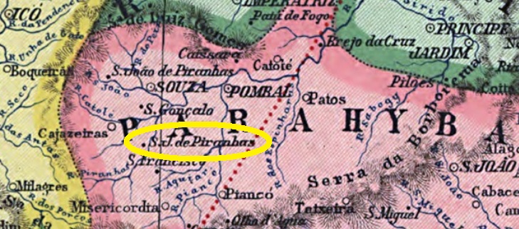
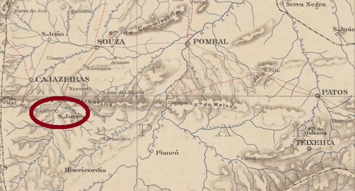
This village, whose name merges Jesus father with a carnivorous fish, was from November 1840 a freguesia of Cajazeiras, located on the west bank of the Piranhas River, 470 km west of the provincial capital Parahyba do Norte (today: João Pessoa). It was elevated to villa in September 1875 and was called Jatobá from November 1938 to December 1952. This is the Brazilian name for a tree of the Fabaceae family (Hymenaea courbaril, Linnaeus), native to whole South America and economically quite important.
Hymenaea courbaril (Photo: Mauro Guanandi, CC BY-2.0)
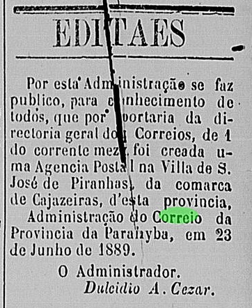
The local post office was established in June 1889, as can be read in the regional press:
Liberal Parahybano, 10 July 1889
So far, no postmark of the imperial era has been seen from this place.
Serviço Geológico e Mineralógico do Brasil, 1910
Anderer Name: Jatobá (1938-1952)
Diese Ortschaft, dessen Namen Jesus Vater mit einem fleischfressenden Fisch verbindet, war ab November 1840 eine Freguesia von Cajazeiras, die am Westufer des Flusses Piranhas lag, 470 km westlich der Provinzhauptstadt Parahyba do Norte (heute: João Pessoa) entfernt. Sie wurde im September 1875 zur Villa erhoben, und hieß von November 1938 bis Dezember 1952 Jatobá. So wird in Brasilien ein Baum der Johannisbrotgewächse (Hymenaea courbaril, Linnaeus) genannt, der im ganz Südamerika beheimatet und vielfach nützlich ist.
Hymenaea courbaril (Foto: Mauro Guanandi, CC BY-2.0)
Das örtliche Postamt entstand im Juni 1889, wie aus der Regionalpresse hervorgeht:
Liberal Parahybano, 10. Juli 1889
Bisher wurde kein Poststempel der Kaiserzeit aus diesem Ort gesehen.
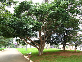
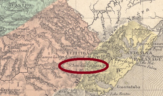
Already in the 18th century, São José dos Pinhais was a freguesia of Curitiba, which was located about 15 km southeast of the later provincial capital. It was elevated to a villa in July 1852, the year before the founding of the province of Paraná and has been a city since December 1897. Today, S. José dos Pinhais is practically the industrial suburb of Curitiba, where the capital’s airport is located.
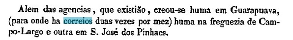
Two operating periods for the local post office were found, the first of which was in the time when São José dos Pinhaes still belonged to the province of São Paulo. It first opened in 1831, according to Pereira and Oliveira Filho (Subsídios Historicos e Estatisticos de Correios e Telegrafos, Rio de Janeiro, 1938). This first period ended around 1846, as can be read in the Official Annual Report (Annuario Politico, Historico e Estatistico do Brazil) for 1847. The second postal opening took place in June 1854, according to Nova Monteiro (Administrações e Agencias Postaes do Brasil Imperio, in Brasil Filatelico/RJ, 1934-5; Reprint SPP 1994-1999). This is confirmed by the Provincial President’s report from the following month:
Relatório do Presidente da Provincia, July 1854
Only one imperial postmark in the second period of this agency’s operation was found. SPR-0195c (Coll. José A. Junges) exists also in blue and is a simple double circle with the inscription S. J. DOS PINHAES. The dates inside are from 1878 to 1885.
Villiers de l’Ile Adam: Carta (…) da Provincia de São Paulo, 1847
Anderer Name: São José
São José dos Pinhaes (heute Pinhais geschrieben) war schon im 18. Jahrhundert eine Freguesia der Villa Curitiba, die gut 15 km südöstlich der späteren Provinzhauptstadt entfernt lag. Sie wurde im Juli 1852 zur Villa erhoben, also im Jahr vor der Gründung der Provinz Paraná, und ist eine Stadt seit Dezember 1897. Heute ist S. José dos Pinhais praktisch der Industrievorort von Curitiba, wo der Flughafen der Hauptstadt liegt.
Zwei Betriebsperioden fürs örtliche Postamt wurde gefunden, die erste davon in der Zeit, als São José dos Pinhaes noch der Provinz São Paulo gehörte. Erstmals eröffnet wurde es um 1831, wie Pereira und Oliveira Filho (Subsídios Historicos de Estatisticos de Correios e Telegrafos, Rio de Janeiro, 1938) berichten. Diese erste Periode endete um 1846, wie im Amtlichen Jahresbericht (Annuario Politico, Historico e Estatistico do Brazil) für 1847 zu lesen ist. Die zweite Posteröffnung fand im Juni 1854 statt, laut Nova Monteiro (Administrações e Agencias Postaes do Brasil Imperio, in Brasil Filatelico/RJ, 1934-5; Reprint SPP 1994-1999). Die wird durch den Bericht des Provinzpräsidenten im folgenden Monat bestätigt:
Relatório do Presidente da Provincia, Juli 1854
Nur ein kaiserlicher Poststempel im zweiten Betriebsperiode dieser Agentur wurde gefunden. SPR-0195c (Samml. José A. Junges) kommt auch in blau vor und ist ein schlichter Doppelkreis mit der Inschrift S. J. DOS PINHAES. Die Daten in der Mitte gehen von 1878 bis 1885.