Categories
Carimbologia S

São Francisco de Paula dos Pinheiros, São Paulo (SSP-1565)

Atlas do Imperio do Brasil, 1868

Print edition update, on February 23, 2021

See also Pinheiros/SP (R. Koester: Carimbologia XXXI)

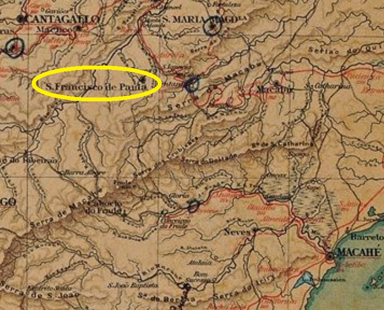
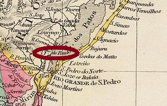
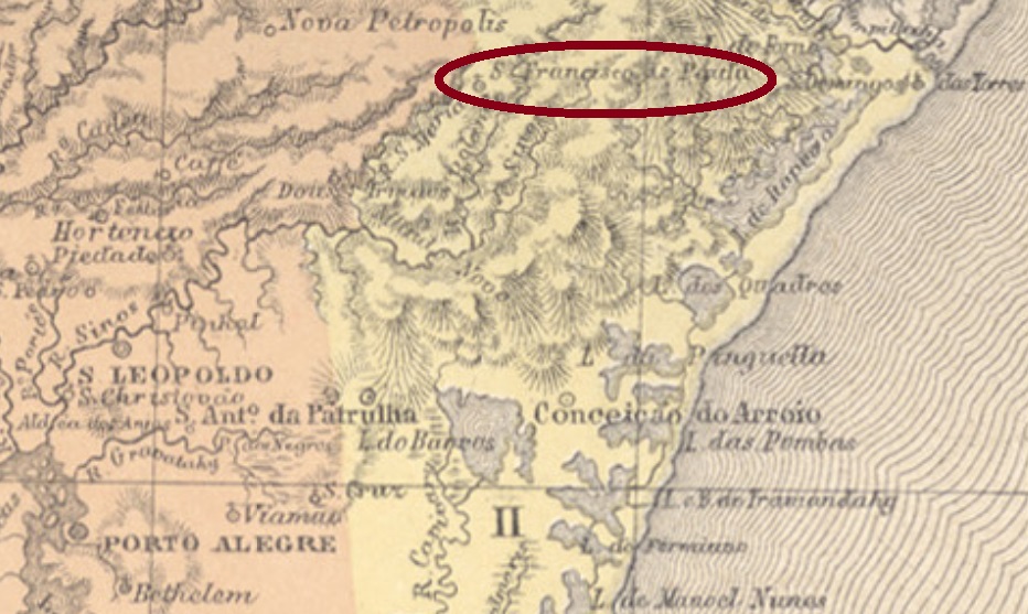
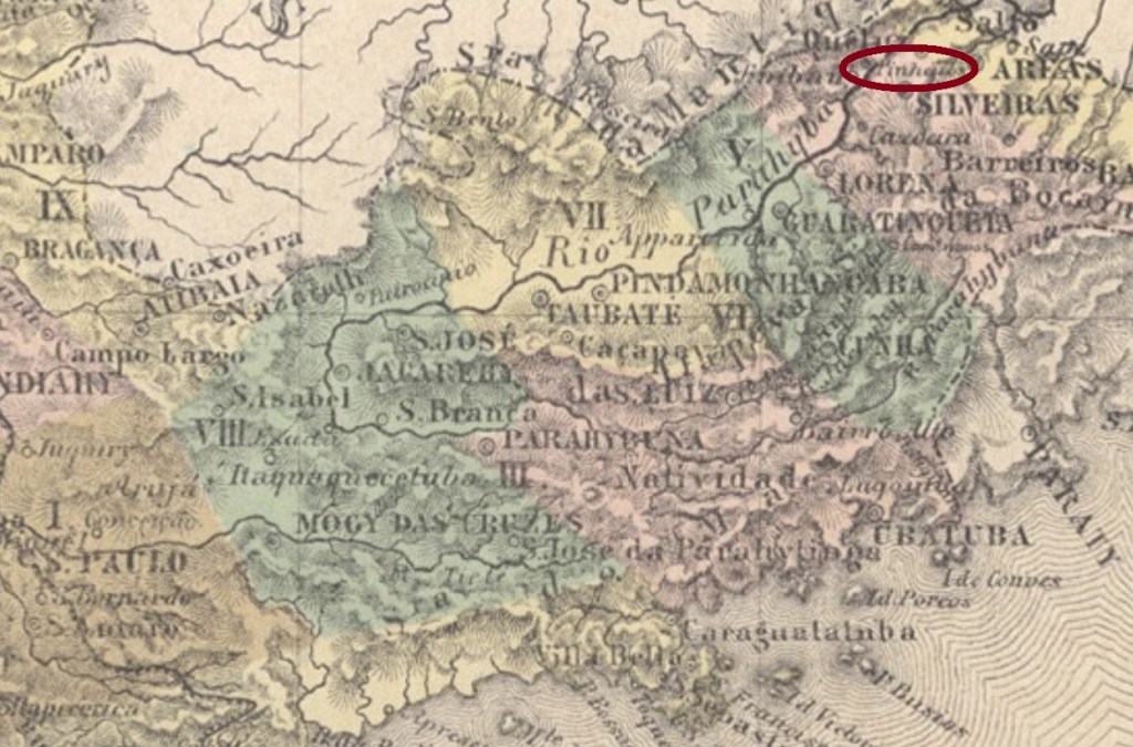
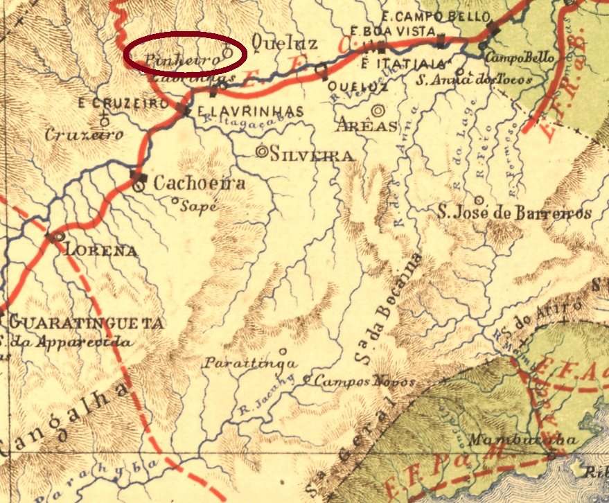
São Francisco de Paula dos Pinheiros was from March 1846 on a freguesia located in the municipality of Queluz, about 230 km northeast of the provincial capital of São Paulo. The village arose twice to a municipality, in December 1917 and in September 1937. It then descended twice to a district: in May 1934 and in November 1944, most recently in the municipality of Lavrinhas. Time seems to have stopped here: in 1880 there were more than 2.7 thousand people living there, in 2010 there were just 2,000 inhabitants on place.

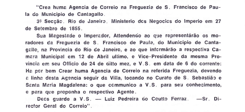
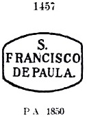
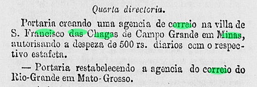
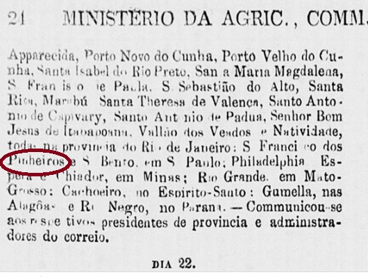
This ups and downs were reflected in the postal system. Nova Monteiro (Administrações e Agencias Postaes do Brasil Imperio, in Brasil Filatelico/RJ, 1934-5; Reprint SPP 1994-1999) reports a post office creation in September 1860. But as early as June 1861, the locality was on a list of deleted postal agencies:

Expediente do Ministério do Império, 21 June 1861

It took a while until the reopening, because it was not until November 1867 that Pinheiros reappeared in reports about postal routes. No cancel of the imperial period has been found yet under this name. For postmarks with Pinheiros/SP, see Koesters Carimbologia XXXI.

Estrada de Ferro Central do Brasil, 1890

Buchtext-Aktualisierung vom 23. Februar 2021

Siehe auch Pinheiros/SP (R. Koester: Carimbologia XXXI)

São Francisco de Paula dos Pinheiros war ab März 1846 eine Freguesia im Município von Queluz, ca. 230 km nordöstlich der Provinzhauptstadt São Paulo gelegen. Der Ort stieg zweimal zum Município auf, im Dezember 1917 und im September 1937. Und stieg anschließend zweimal zum Distrikt ab: im Mai 1934 und im November 1944, zuletzt im Município von Lavrinhas. Hier scheint die Zeit stehen geblieben zu sein: 1880 lebten dort über 2,7 tausend Menschen, im Jahre 2010 waren gerade 2.000 Einwohner dort gemeldet.

Dieses Auf und Ab spiegelte sich im Postwesen wider. Nova Monteiro (Administrações e Agencias Postaes do Brasil Imperio, in Brasil Filatelico/RJ, 1934-5; Reprint SPP 1994-1999) berichtet, das dortige Postamt eröffnete im September 1860. Aber bereits im Juni 1861 stand dieser Ort auf einer Liste von gelöschten Postagenturen:

Expediente do Ministério do Império, 21. Juni 1861

Es dauerte noch eine Weile bis zur Neueröffnung, denn erst im November 1867 erschien Pinheiros in Meldungen über Postrouten wieder. Kein Stempel der Kaiserzeit wurde bisher unter diesem Namen gefunden. Für Stempel mit Pinheiros/SP siehe Koesters Carimbologia XXXI.

Categories
Carimbologia S

São Francisco de Paula de Oliveira, Minas Gerais (SMG-2275)

Atlas do Imperio do Brasil, 1868

Other names: Jacareguai, São Francisco de Oliveira, Wenceslau Braz

From December 1867 on, this São Francisco de Paula from the province of Minas Gerais was a freguesia of Oliveira, which was located more than 200 km west of the capital Ouro Preto. In September 1923, the place name changed to Jacareguai. This name is an Indian-looking merge of crocodile (yacaré) and human (guai) and did not please the population at all. A year later, the town was called S. Francisco de Oliveira, and in December 1962 the political emancipation came under the name of Município of Wenceslau Braz, in memory of the former president of Brazil (1868-1966).  However, given that in 1964 another municipality with the same name was created in Minas Gerais, the original name of S. Francisco de Paula returned definitively in June 1976.

According to Paula Sobrinho (História Postal de Minas Gerais, Belo Horizonte, 1997), there has been a post office there since December 1879. Unfortunately, there is a single copy of the only cancel in the Empire so far, which shows only its right half. SMG-2275a (Coll. Dieter Kerkhoff) appears in purple in an edition of 1885 and consists of a double circle with the inscriptions (…) E PAULA above and (…) LIVEIRA below. Date at the centre.

Provincia de Minas Geraes, 1873

Andere Namen: Jacareguai, São Francisco de Oliveira, Wenceslau Braz

Dieser São Francisco de Paula aus der Provinz Minas Gerais war ab Dezember 1867 eine Freguesia von Oliveira, die über 200 km westlich von der Hauptstadt Ouro Preto entfernt lag. Im September 1923 wechselte der Ortsname zu Jacareguai. Dieser Name ist eine indianisch anmutende Erfindung aus Krokodil (yacaré) und Mensch (guai) und kam überhaupt nicht bei der Bevölkerung an. Ein Jahr später hieß der Ort São Francisco de Oliveira, und im Dezember 1962 kam die politische Emanzipation, unter dem Namen Município von Wenceslau Braz, in Erinnerung an den ehemaligen Präsidenten Brasiliens (1868-1966).  Da aber 1964 ein weiterer Município mit gleichem Name in Minas Gerais entstanden ist, kehrte der ursprüngliche Name São Francisco de Paula im Juni 1976 definitiv zurück.

Laut Paula Sobrinho (História Postal de Minas Gerais, Belo Horizonte, 1997), gibt es dort ein Postamt seit Dezember 1879. Vom bisher einzigen Stempel im Kaiserreich gibt es leider nur ein Exemplar, das obendrein nur seine rechte Hälfte zeigt. SMG-2275a (Samml. Dieter Kerkhoff) kommt in violett in einer Ausgabe von 1885 vor und besteht aus einem Doppelkreis mit den Inschriften (…)E PAULA oben und (…)LIVEIRA unten. Datum in der Mitte.

Categories
Carimbologia S

São Francisco de Paula (de Cantagallo), Rio de Janeiro (SRJ-0930)

Atlas do Imperio do Brasil, 1868

Other names: S. Francisco de Paula, Trajano de Morais (1938)

This place became a freguesia in the municipality of Cantagallo (= Crowing Cock) in May 1856 and was located about 250 km northeast of the imperial capital Rio de Janeiro. In October 1861 it switched as a district to Santa Maria Magdalena and ascended in May 1891 to a villa in own municipality. Since March 1938, the place is called Trajano de Morais. This was the name of an important landowner of noble family in the region, who died in 1911.

As Nova Monteiro writes in Administrações e Agencias Postaes do Brasil Imperio (Brasil Filatelico/RJ, 1934-5; Reprint SPP 1994-1999), the local post office was established in October 1855. This is confirmed by Aureo G. Santos in Agencias de Correio Criadas e Suprimidas 1851, 1855, 1856 e 1857 (Brasil Filatélico 181, Rio de Janeiro, 1977):

Aureo G. Santos (op. cit.)

The first postmark, SRJ-0930a, is also available in blue; it circulated until at least 1866 and was already presented by Paulo Ayres (Catalogo de Carimbos Brasil-Império, S. Paulo, 1937, 1942) under No. 1457:

SRJ-0930a (P.A. 1457)

Three cancels with double circles followed. At SRJ-0930b (agenciaspostais.com.br) we have the inscription S.F. DE PAULA above and an (I) below. Dates at the centre: 1877-1888. The upper inscription in SRJ-0930c (agenciaspostais.com.br) is S. Fco. DE PAULA DE CANTAGALLO, below there is an oval ornament, which consists of four small triangles, and has a diamond space in its centre. Dates: ca.1884-1893. SRJ-0930d (Coll. Dieter Kerkhoff) could already be Republican, for its dates at the centre cover the period 1894-1897. Here is the inscription S. FRANco. DE PAULA DE CANTAGALLO above, with a cross-shaped ornament at the bottom.

Almanak Laemmert, 1892

Andere Namen: S. Francisco de Paula, Trajano de Morais (1938)

Dieser Ort wurde im Mai 1856 zur Freguesia im Município von Cantagallo (= Krähender Hahn) und lag ca. 250 km nordöstlich der kaiserlichen Hauptstadt Rio de Janeiro. Im Oktober 1861 stieg er zum Distrikt und, im Mai1891, zur Villa im eigenem Município. Seit März 1938 gilt der Ortsname Trajano de Morais. So hieß ein Großgrundbesitzer aus einer Adelsfamilie der Region, der 1911 starb.

Wie Nova Monteiro im Administrações e Agencias Postaes do Brasil Imperio (Brasil Filatelico/RJ, 1934-5; Reprint SPP 1994-1999) schreibt, entstadn das örtliche Postamt im Oktober 1855. Das wird durch Aureo G. Santos in Agências de Correio Criadas e Suprimidas 1851, 1855, 1856 e 1857 (Brasil Filatélico 181, Rio de Janeiro, 1977) bestätigt:

Aureo G. Santos (op. cit.)

Den ersten Poststempel SRJ-0930a gibt es auch in Blau; er war bis mindestens 1866 im Umlauf und wurde bereits durch Paulo Ayres (Catálogo de Carimbos Brasil-Império, S. Paulo, 1937, 1942) unter Nr. 1457 vorgestellt:

SRJ-0930a (P.A. 1457)

Es folgten drei Stempel mit Doppelkreisen. Bei SRJ-0930b (agenciaspostais.com.br) haben wir die Inschrift S.F. DE PAULA oben und einem (I) unten. Die Daten in der Mitte: 1877-1888. Die obere Inschrift in SRJ-0930c (agenciaspostais.com.br) lautet S. Fco. DE PAULA DE CANTAGALLO, unten gibt es ein Ornament im Oval, das aus vier kleinen Dreiecken besteht und einen Leerraum in Rautenform in seiner Mitte hat. Daten: ca.1884-1893. SRJ-0930d (Samml. Dieter Kerkhoff) könnte bereits republikanisch sein, da seine Daten in der Mitte den Zeitraum 1894-1897 umfassen. Hier lautet die Inschrift S. FRANco. DE PAULA DE CANTAGALLO oben, mit einem kreuzförmigen Ornament unten.

Categories
Carimbologia S

São Francisco de Paula de Cacimbas, Rio de Janeiro (SRJ-1370)

Atlas do Imperio do Brasil, 1868

Other names: Cacimbas, Sao Francisco de Itabapoana (1995)

The word Cacimba probably has African origin and means pit. São Francisco de Paula de Cacimbas was since October 1857 a district of São João da Barra, situated more than 300 km northeast of the imperial capital Rio de Janeiro. In 1916, the place name was shortened to Cacimbas. In January 1995 came the political emancipation, as a municipality of S. Francisco do Itabapoana.

Nova Monteiro writes in Administrações e Agencias Postaes do Brasil Imperio (Brasil Filatelico/RJ, 1934-5; Reprint SPP 1994-1999) that there is a post office on place since December 1866. An early postmark could be found, probably not the oldest, since it has dates between 1891 and 1897. SRJ-1370b (agenciaspostais.com.br) has a double circle with the inscription S. FRANco DE PAULA DE CACIMBAS above and a three-point column below, along with date at the centre.

Villiers de l’Ile Adam: Carta (…) da Provincia do Rio de Janeiro, 1850

Andere Namen: Cacimbas, São Francisco de Itabapoana (1995)

Das Wort Cacimba hat wohl afrikanischen Ursprung und bedeutet Grube. São Francisco de Paula de Cacimbas war ab Oktober 1857 ein Distrikt von São João da Barra und lag über 300 km nordöstlich der kaiserlichen Hauptstadt Rio de Janeiro. 1916 wurde der Ortsname zu Cacimbas gekürzt. Im Januar 1995 kam die politische Emanzipation, als Município von São Francisco do Itabapoana.

Wie Nova Monteiro in Administrações e Agencias Postaes do Brasil Imperio (Brasil Filatelico/RJ, 1934-5; Reprint SPP 1994-1999) schreibt, gibt es dort ein Postamt seit Dezember 1866. Ein früher Poststempel war noch zu finden, wahrscheinlich nicht der älteste, da seine Daten zwischen 1891 und 1897 liegen. SRJ-1370b (agenciaspostais.com.br) hat einen Doppelkreis mit der Inschrift S. FRANco DE PAULA DE CACIMBAS oben und drei aufeinander liegende Punkte unten, dazu Datum in der Mitte.

Categories
Carimbologia S

São Francisco de Paula (Pelotas), Rio Grande do Sul (SRS-0311)

John Arrowsmith: Brazil, 1844

See also Pelotas (R. Koester: Carimbologia XXX)

This is the original name of the traditional city of Pelotas. Founded in July 1812 as the freguesia of São Francisco de Paula de Pelotas, the locality became a villa in December 1832 and a town in June 1835.

Two creation dates for the local post office were found. Nova Monteiro (Administrações e Agencias Postaes do Brasil Imperio, in Brasil Filatelico/RJ, 1934-5; Reprint SPP 1994-1999) writes 12 October 1831, while Reinhold Koester (Carimbologia XXX) indicates the year 1847. Both are probably correct, as one can assume an agency closure during the Farroupilha Revolution (1835-1845). However, there would have to be a third, earlier date, for there is the cancel SRS-0311a. This was found in documents between 1824 and 1828 in sepia and red and was already shown in the RHM catalogue under P-RS-24:

SRS-0311a (RHM P-RS-24)

For cancels featuring PELOTAS see Koester’s Carimbologia XXX.

Villiers de l’Ile Adam: Carta (…) da Provincia de São Pedro do Sul, 1847

Siehe auch Pelotas (R. Koester: Carimbologia XXX)

Dieser ist der ursprüngliche Name der traditionsreichen Stadt Pelotas. Gegründet im Juli 1812 als die Freguesia von São Francisco de Paula de Pelotas, wurde die Ortschaft im Dezember 1832 zur Villa und im Juni 1835 zur Stadt.

Zwei Gründungsdaten fürs örtliche Postamt wurden ermittelt. Nova Monteiro (Administrações e Agencias Postaes do Brasil Imperio, in Brasil Filatelico/RJ, 1934-5; Reprint SPP 1994-1999) schreibt dafür den 12. Oktober 1831, während Reinhold Koester (Carimbologia XXX) das Jahr 1847 angibt. Beide werden wohl stimmen, da man von einer Agenturschließung während der Farroupilha-Revolution (1835-1845) ausgehen kann. Allerdings müsste es noch ein drittes, früheres Datum geben, weil es den Stempel SRS-0311a gibt. Dieser wurde in Belegen zwischen 1824 und 1828 in den Farben Sepia und Rot gefunden und war bereits im RHM Katalog unter P-RS-24 zu sehen:

SRS-0311a (RHM P-RS-24)

Für Stempel mit PELOTAS siehe Koester: Carimbologia XXX.

Categories
Carimbologia S

São Francisco de Paula (Juiz de Fora), Minas Gerais (SMG-2274)

Atlas do Imperio do Brasil, 1868

Another name: Torreões (1943)

From March 1840, this São Francisco de Paula was a parish in the municipality of Parahybuna (now Juiz de Fora), located on the eastern bank of the Rio do Peixe, about 250 km south of the provincial capital Ouro Preto. In May 1858 it became a district, which since December 1943 is called Torreões.

According to Paula Sobrinho (História Postal de Minas Gerais, Belo Horizonte, 1997), there has been a post office there since July 1881. A cancel of the imperial period was found. SMG-2274a (Coll. Alf Dombrowe) consists of a double circle with the inscriptions S. FRANco. DE PAULA above and (JUIZ DE FORA) below. The only copy has a date from 1885 at the centre.

Provincia de Minas Geraes, 1873

Anderer Name: Torreões (1943)

Dieser São Francisco de Paula war ab März 1840 eine Pfarrei im Município von Parahybuna (heute Juiz de Fora) und lag am Ostufer des Rio do Peixe, rund 250 km südlich der Provinzhauptstadt Ouro Preto. Im Mai 1858 wurde daraus ein Distrikt, der seit Dezember 1943 Torreões heißt.

Laut Paula Sobrinho (História Postal de Minas Gerais, Belo Horizonte, 1997), gibt es dort ein Postamt seit Juli 1881. Ein Stempel der Kaiserzeit wurde gefunden. SMG-2274a (Samml. Alf Dombrowe) besteht aus einem Doppelkreis mit den Inschriften S. FRANco. DE PAULA oben und (JUIZ DE FORA) unten. Das einzige Exemplar bisher ist mit einem Datum aus 1885 in der Mitte versehen.

Categories
Carimbologia S

São Francisco de Paula, Rio Grande do Sul (SRS-0310)

Atlas do Imperio do Brasil, 1868

Print edition update, on March 3, 2021

Other names: São Francisco de Paula de Cima da Serra, Cima da Serra, Serra

See also Cima da Serra (R. Koester: Carimbologia XI)

São Francisco de Paula de Cima da Serra (= on the Mountains) was a district in the municipality of Taquara do Mundo Novo (now Taquara), about 120 km northeast of the provincial capital Porto Alegre. The political emancipation as an independent municipality came in December 1902, and since about 1920 the city has been called only S. Francisco de Paula, although in southern Brazil the pet name São Chico is often used.

According to Nova Monteiro (Administrações e Agencias Postaes do Brasil Imperio, in Brasil Filatelico/RJ, 1934-5; Reprint SPP 1994-1999) the local post office was established in July 1866. Only one cancel could be surely assigned here, probably not the oldest one. SRS-0310b (Coll. Klerman W. Lopes) has a double circle with the inscriptions S. F. DE PAULA above and (2) below. Dates of 1884 and 1885 at the centre.

Villiers de l’Ile Adam: Carta (…) da Provincia de São Pedro do Sul, 1847

Aktualisierung der Printausgabe, am 3. März 2021

Andere Namen: S. Francisco de Paula de Cima da Serra, Cima da Serra, Serra

Siehe auch Cima da Serra (R. Koester, Carimbologia XI)

São Francisco de Paula de Cima da Serra (=auf dem Gebirge) war ab November 1852 ein Distrikt im Município von Taquara do Mundo Novo (heute einfach Taquara), der ca. 120 km nordöstlich der Provinzhauptstadt Porto Alegre entfernt lag. Die politische Emanzipation als eigenständiger Município kam im Dezember 1902, und seit ca. 1920 heißt die Stadt lediglich São Francisco de Paula, obwohl im Südbrasilien die Koseform São Chico gern und oft angewendet wird.

Laut Nova Monteiro (Administrações e Agencias Postaes do Brasil Imperio, in Brasil Filatelico/RJ, 1934-5; Reprint SPP 1994-1999) entstand das örtliche Postamt im Juli 1866. Nur ein Stempel konnte sicher dorthin zugeordnet werden, und dieser ist wohl nicht der Älteste. SRS-0310b (Samml. Klerman W. Lopes) hat einen Doppelkreis mit den Inschriften S. F. DE PAULA oben und (2) unten. Daten von 1884 und 1885 in der Mitte.

Categories
Carimbologia S

São Francisco do Glória, Minas Gerais (SMG-2290)

Atlas do Imperio do Brasil, 1868

São Francisco do Glória (also written da Glória) was a district in the municipality of São Paulo de Muriahé, close to the eastern bank of the River Glória, about 200 km east of the provincial capital Ouro Preto. In November 1878, it switched to the municipality of Carangola and acquired political emancipation as a municipality in December 1953.

According to Paula Sobrinho (História Postal de Minas Gerais, Belo Horizonte, 1997), there has been a post office there since November 1882. This can be ratified through the Rio press:

Jornal do Commercio/RJ, November 17, 1882

No imperial postmark of this village has been seen so far.

Provincia de Minas Geraes, 1873

São Francisco do Glória (auch da Glória geschrieben) war ab Juni 1858 ein Distrikt im Município von São Paulo de Muriahé, der nah am Ostufer des Flusses Glória, ca. 200 km östlich der Provinzhauptstadt Ouro Preto entfernt lag. Im November 1878 wechselte er zur Gemeinde von Carangola und erhielt die politische Emanzipation als Município im Dezember 1953.

Laut Paula Sobrinho (História Postal de Minas Gerais, Belo Horizonte, 1997) gibt es dort ein Postamt seit November 1882. Dieses wird von der Rio-Presse bestätigt:

Jornal do Commercio/RJ, 17.11.1882

Kein Poststempel dieser Ortschaft aus der Kaiserzeit wurde bisher gesichtet.

Categories
Carimbologia S

São Francisco das Chagas do Monte Alegre, Minas Gerais (SMG-2262)

Atlas do Imperio do Brasil, 1868

Book text update from February 15, 2021

Other name: Monte Alegre de Minas (1948)

See also Monte Alegre (R. Koester: Carimbologia XXVII)

From July 1843 on, the locality of Sao Francisco de Chagas do Monte Alegre was a district in the municipality of Prata, located almost 700 km west of the provincial capital Ouro Preto. In September 1870 the village rose to a villa, and in January 1880 to a town called Monte Alegre de Minas since December 1948.

According to Paula Sobrinho (História Postal de Minas Gerais, Belo Horizonte, 1997), there has been a post office there since June 1872. In Carimbologia S1 a cancel was presented under SMG-2262a, which supposedly would be assigned to this place. In the meantime, it turned out that the cancel was more likely to belong to São Francisco das Chagas de Campo Grande (as SMG-2260c). As can be read in R. Koester’s Carimbologia XXVII, all postmarks found so far from S. Francisco das Chagas do Monte Alegre bear the abbreviated toponym MONTE ALEGRE.

Villiers de l’Ile Adam: Carta (…) da Provincia de Minas Geraes, 1849

Buchtext-Aktualisierung v. 15. Februar 2021

Anderer Name: Monte Alegre de Minas (1948)

Siehe auch Monte Alegre (R. Koester: Carimbologia XXVII)

São Francisco de Chagas do Monte Alegre war ab Juli 1843 ein Distrikt im Município von Prata, der fast 700 km westlich der Provinzhauptstadt Ouro Preto entfernt lag. Im September 1870 stieg der Ort zur Villa, und im Januar 1880 zu einer Stadt, die seit Dezember 1948 Monte Alegre de Minas heißt.

Laut Paula Sobrinho (História Postal de Minas Gerais, Belo Horizonte, 1997) gibt es dort ein Postamt seit Juni 1872. Im Carimbologia S1 wurde ein Stempel unter SMG-2262a vorgestellt, der vermeintlich diesem Ort zuzuordnen wäre. Inzwischen stellte sich heraus, dass der Stempel eher zu São Francisco das Chagas do Campo Grande (als SMG-2260c) gehören soll. Wie aus R. Koesters Carimbologia XXVII hervorgeht,  tragen alle bisher gefundenen postalischen Entwertungen aus São Francisco das Chagas do Monte Alegre den gekürzten Ortsnamen MONTE ALEGRE.

Categories
Carimbologia S

São Francisco das Chagas do Campo Grande, Minas Gerais (SMG-2260)

Mappa de Minas Geraes, 1910

Print edition update, on February 14, 2021

Other name: Rio Paranaíba (1911-14, 1923)

This village was located more than 400 km northwest of the provincial capital Ouro Preto, just a few kilometers away from the source of the Paranaiba River. From April 1846 on it was a district of Araxá, which arose to a villa as early as September 1848. However, it was not until June 1861 that the new administration was installed. From August 1911 to September 1914, the municipality was called Rio Paranaíba, after which it was demoted as a district of São Gotardo. The political independence of the municipality returned in September 1923 together with the name Rio Paranaíba.

Two dates were found for the creation of the local post office. Nova Monteiro writes November 28, 1861 in Administrações e Agencias Postaes do Brasil Imperio (Brasil Filatelico /RJ, 1934-5; Reprint SPP 1994-1999), which is confirmed both by the Imperial Mail Register (Tabella das Agencias do Correio do Imperio) of 1885 and by ministerial protocols:

Boletim do Expediente do Governo, 28.11.1861

The second date of creation for the agency would be 28 October 1873, as Paula Sobrinho reports (História Postal de Minas Gerais, Belo Horizonte, 1997). But there may be a mix-up with the neighbouring town of Carmo do Arraial Novo, whose post office was created on that very date.

The earliest cancel for this place is probably SMG-2260a (Coll. Fuad Ferreira Fo.). Since its illustration appeared after the printing of Carimbologia S1, it is shown here: 

SMG-2260a (Coll. Fuad Ferreira Fo.)

There follows SMG-2260b (Coll. José A. Junges): a double circle with the inscription S. FRAN.CO DAS CHAGAS DO CAMPO GR.DE above and a cross-shaped ornament at the bottom. The only seen copy has a date of 1890 at the centre. The third cancel is likely to be Republican. SMG-2260c (Coll. Dieter Kerkhoff) was mistakenly attributed to the São Francisco das Chagas do Monte Alegre (as SMG-2262a) in Carimbologia S1: a double circle with inscription S. FRAN. DAS CHAGAS above and (MINAS) below. Also here there is only one copy, dated 1899 at  the centre.

At the start of the postal services, from about 1866, a handwritten cancellation in blue ink was also used, although the place name is not fully written (Coll. José A. Junges):

Coll. José A. Junges
Atlas do Imperio do Brasil, 1868

Buchtext-Aktualisierung v. 14. Februar 2021

Anderer Name: Rio Paranaíba (1911-14, 1923)

Diese Ortschaft lag über 400 km nordwestlich der Provinzhauptstadt Ouro Preto, wenige Kilometer von der Quelle des Paranaiba-Flusses entfernt, und war ab April 1846 ein Distrikt von Araxá, der schon im September 1848 zur Villa erhoben wurde. Allerdings konnte erst im Juni 1861 die neue Verwaltung installiert werden. Vom August 1911 bis September 1914 hieß der Município Rio Paranaíba, danach wurde der Ort als Distrikt von São Gotardo degradiert. Die politische Eigenständigkeit der Gemeinde kehrte dann doch im September 1923 zusammen mit dem Namen Rio Paranaíba zurück.

Es liegen zwei Daten fürs örtliche Postamt vor. Nova Monteiro (Administrações e Agencias Postaes do Brasil Imperio, in Brasil Filatelico/RJ, 1934-5; Reprint SPP 1994-1999) schreibt dafür den 28. November 1861, was sowohl durch das Verzeichnis der kaiserlichen Postämter (Tabella das Agencias do Correio do Imperio) von 1885 als auch durch das ministeriale Behördenprotokoll bestätigt wird:

Boletim do Expediente do Governo, 28.11.1861

Das zweite Entstehungsdatum für die Agentur wäre der 28. Oktober 1873, wie Paula Sobrinho berichtet (História Postal de Minas Gerais, Belo Horizonte, 1997). Aber hier liegt womöglich eine Verwechslung mit dem Nachbarort Carmo do Arraial Novo vor, dessen Postamt zu genau diesem Datum entstanden ist.

Der früheste Stempel für diesen Ort wird wohl SMG-2260a sein (Samml. Fuad Ferreira Fo.). Da dessen Abbildung nach der Drucklegung von Carimbologia S1 auftauchte, wird sie hier gezeigt:  

SMG-2260a (Samml. Fuad Fereira Fo.)

Ihm folgt SMG-2260b (Samml. José A. Junges): ein Doppelkreis mit der Inschrift S. FRAN.CO DAS CHAGAS DO CAMPO GR.DE oben und einem kreuzförmigen Ornament unten. Das einzig gesichtete Exemplar hat ein Datum von 1890 in der Mitte. Der dritte Stempel wird wohl republikanisch sein. SMG-2260c (Samml. Dieter Kerkhoff) wurde in Carimbologia S1 irrtümlich São Francisco das Chagas do Monte Alegre (als SMG-2262a) zugeschrieben: ein Doppelkreis mit Inschriften S. FRAN. DAS CHAGAS oben und (MINAS) unten. Auch hier nur ein Exemplar, datiert 1899 in der Mitte.

Zu Beginn des Postbetriebs, ab ca. 1866, wurde auch eine handgeschriebene Entwertung in blauer Tinte verwendet, wobei der Ortsname nicht vollständig zu lesen ist (Samml. José A. Junges):

Samml. José A. Junges