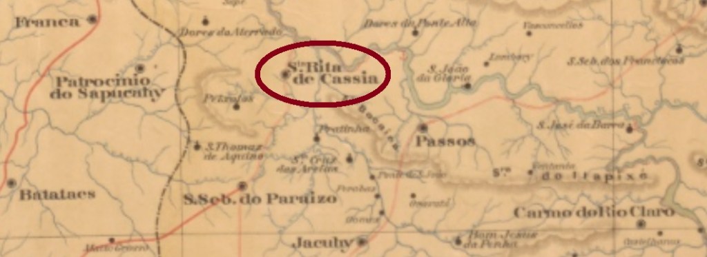
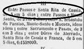
According to the Postal Guide (Guia Postal do Imperio) of 1880, there were two localities named Santa Rita de Cassia in Minas Gerais. The bigger one (ca. 2.4 thousand inhabitants) was Santa Rita de Cássia do Rio Claro near Caldas, the smaller (less than 2 thousand people), near Passos. It seems that the post office was created in the small Santa Rita, as this mail route reveals:
A Provincia de Minas, September 12, 1887
This Santa Rita de Cassia was since May 1855 a district of the municipality of Passos, which passed in January 1866 to Jacuhy. In 1890 it was elevated to a villa, and two years later, to a town, which simplified its toponym to Cássia in 1919.
Paula Sobrinho (História Postal de Minas Gerais, Belo Horizonte, 1997) tells us that the post office was created in July 1881. One imperial cancel is known: SMG-2905a (Coll. José A. Junges) features a double circle with the inscription S. RITA DE CASSIA above and a diamond ornament below, whose four sides are open. The dates in the centre come from the period 1881ff-1894.
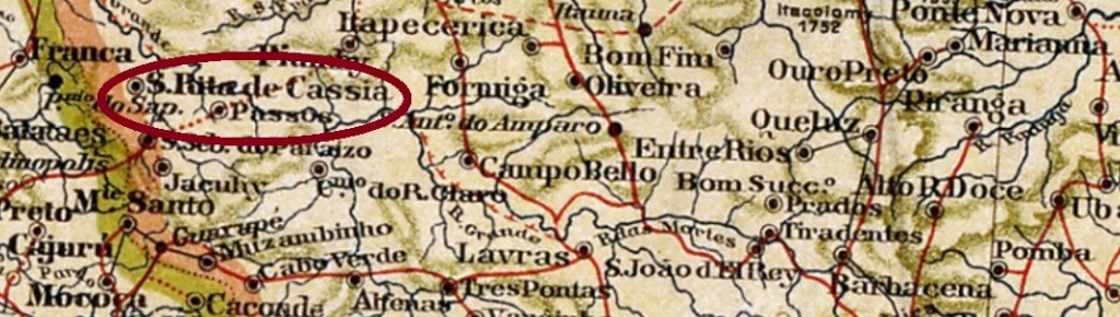
Mapa de Minas Geraes, 1911
Anderer Name: Cássia (1919)
Laut dem Postführer (Guia Postal do Imperio) vom 1880 gab es zwei Ortschaften in Minas Gerais, die Santa Rita de Cássia hießen. Die größte davon (ca. 2,4 tausend Einwohner) war Santa Rita de Cássia do Rio Claro bei Caldas, die andere (knapp 2 tausend Seelen) lag bei Passos. Es scheint, dass das gesuchte Postamt in der kleineren Santa Rita de Cássia errichtet wurde, wie diese Postroute uns zeigt:
A Provincia de Minas, 12. September 1887
Diese Santa Rita de Cassia war seit Mai 1855 ein Distrikt im Município von Passos, der 1866 zu Jacuhy wechselte. 1890 wurde daraus eine Villa, und zwei Jahre später eine Stadt, die 1919 den Ortsnamen auf Cássia vereinfachte.
Paula Sobrinho (História Postal de Minas Gerais, Belo Horizonte, 1997) sagt uns, dass das Postamt im Juli 1881 entstand. Eine Abstempelung des Kaiserreichs ist überliefert: SMG-2905a (Samml. José A. Junges) zeigt einen Doppelkreis mit der Inschrift S. RITA DE CASSIA oben und einem rautenförmigen Ornament unten, dessen vier Seiten offen sind. Die Daten in der Mitte stammen aus dem Zeitraum 1881ff-1894.
Other names: Trahiry, Santa Cruz da Ribeira do Trahiry
See also: Santa Cruz (SRN-0220)
Santa Rita da Cachoeira was since March 1835 a freguesia, situated over 130 km southwest of the province capital Natal. In 1864 it changed as a district of São José de Mipibu and became the Villa of Trahiry in own municipality in December 1876. Since November 1914 it is the municipality of Santa Cruz.
Carta da Republica dos Estados Unidos do Brazil, 1892
Andere Namen: Trahiry, Santa Cruz da Ribeira do Trahiry
See also: Santa Cruz (SRN-0220)
Santa Rita da Cachoeira war seit März 1835 eine Freguesia und lag über 130 km südwestlich der Provinzhauptstadt Natal entfernt. 1864 wechselte sie als ein Distrikt zum Município von São José de Mipibu und wurde im Dezember 1876 die Villa von Trahiry. Seit November 1914 ist es der Município von Santa Cruz.
Im Verzeichnis der kaiserlichen Postämter (Tabella das Agencias do Correio do Imperio) von 1885 wird das örtliche Postamt mit Entstehungsjahr 1874 bereits unter dem Namen Santa Cruz aufgelistet. Kein Poststempel aus der Kaiserzeit ist bisher erschienen.
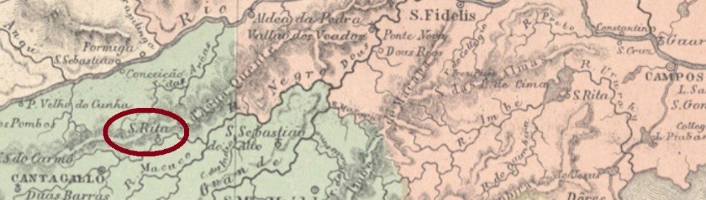
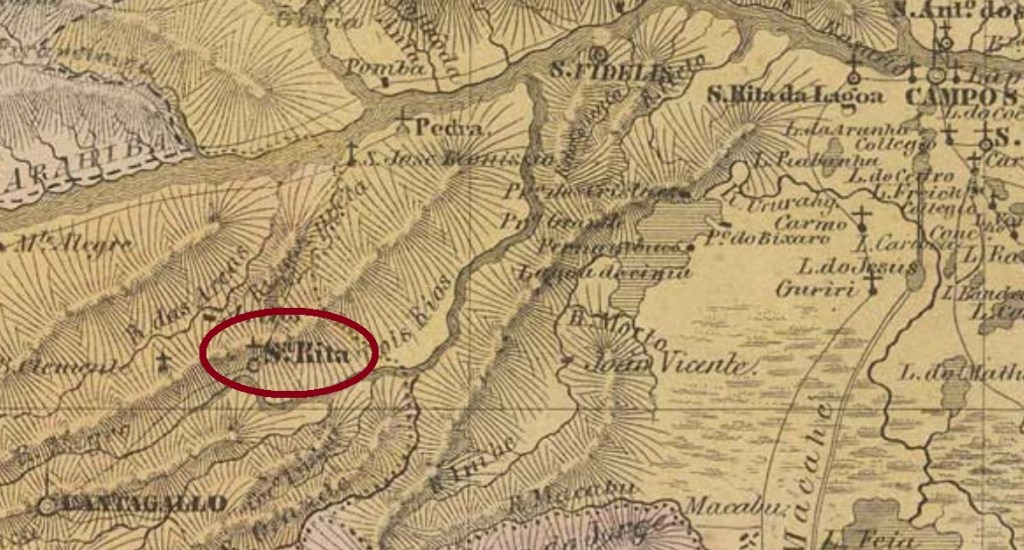
Santa Rita (also written Ritta) was since May 1842 a district of the municipality of Cantagallo, situated on the north bank of the Rio Negro, an affluent to the Rio Grande, over 200 km northeast of the imperial capital Rio de Janeiro. In December 1938 the toponym changed to Rio Negro, but only five years later it changed again, to the actual Euclidelândia. This name is a tribute to the prominent Brazilian writer and engineer Euclides da Cunha (1866-1909), who was born in the region.
The earliest Santa Rita cancel originates from the first period. SRJ-0885a was already presented by Henrique B. Ferreira (Catálogo ilustrado dos carimbos sobre os olhos-de-boi, 4a. ed, Porto Alegre, 2017) and was used from the beginning until at least 1843:
In the real cancel images (Coll. José A. Junges) there is no DE above right. Instead, there are twigs on both upper sides between ovals. Furthermore, there are missing dots after A and C, as shown below:
SRJ-0885b (Coll. José A. Junges)
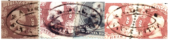
It was followed by SRJ-0885c (Coll. José A. Junges): a double circle with the inscription SANTA RITA above and date in the centre. The examples were found for the period 1877-1885.
From ca. 1886 on the cancels show a complementary DO RIO NEGRO, possibly because there was another locality called Santa Rita in Cantagallo, which was growing fast and had already its own post office, awaiting for the district status, under the toponym Santa Rita da Floresta (SRJ-2295). So the last imperial cancel for the original Santa Rita, SRJ-1545a (agenciaspostais.com.br), has a double circle with the inscription S. RITA DO RIO NEGRO above and the date in the centre. Found with dates between 1886 and 1892.
Villiers de l’Ile Adam: Carta (…) da Provincia do Rio de Janeiro, 1850
Textaktualisierung vom 1. September 2020
Andere Namen: Rio Negro, Euclidelândia (1943)
Santa Rita (auch Ritta geschrieben) war ab Mai 1842 ein Distrikt im Município von Cantagallo und lag am Nordufer des Rio Negro, ein Zufluss des Rio Grande, über 200 km nordöstlich der kaiserlichen Hauptstadt Rio de Janeiro entfernt. Im Dezember 1938 wechselte der Ortsname zu Rio Negro, doch nur fünf Jahre später wechselte er wieder, diesmal zum aktuellen Euclidelândia. Der Name soll an Euclides da Cunha (1866-1909) erinnern, einen prominenten Sohn der Region, der als Literat und Ingenieur eine wichtige Rolle in der Landesgeschichte spielte.
Laut Nova Monteiro (Administrações e Agencias Postaes do Brasil Imperio, in Brasil Filatelico/RJ, 1934-5; Reprint SPP 1994-1999) entstand das örtliche Postamt im November 1833, Paulo Novaes (agenciaspostais.com.br) schreibt dennoch ein Gründungsdatum am 1. Januar 1862. Da diese Agentur noch im Postbericht (Relatorio Postal) für 1860 aufgelistet war, wurde sie wahrscheinlich zwischen beiden Jahren geschlossen.
Der früheste Santa Rita-Stempel stammt noch aus der ersten Betriebsperiode. SRJ-0885a wurde bereits durch Henrique B. Ferreira (Catálogo ilustrado dos carimbos sobre os olhos-de-boi, 4a. ed, Porto Alegre, 2017) vorgestellt und wurde wohl vom Beginn an bis mindestens 1843 gebraucht:
SRJ-0885a (HBF)
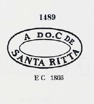
Leider ist die durch Paulo Ayres (unter Nr. 1489 im Catálogo de Carimbos Brasil-Império, S. Paulo, 1937, 1942) überlieferte Abbildung für SRJ-0885b erheblich fehlerhaft:
P. Ayres (op. cit.) Nr. 1489
Tatsächlich zeigen die echten Stempelbilder (Samml. José A. Junges) kein DE oben rechts. Stattdessen sieht man Zweige oben auf beiden Seiten. Außerdem fehlen noch Punkte nach den Buchstaben A und C, wie unten abgebildet:
SRJ-0885b (Samml. José A. Junges)
Dieser Stempel war zwischen 1862 und 1866ff in Gebrauch. Ihm folgte SRJ-0885c (Samml. José A. Junges): ein Doppelkreis mit der Inschrift SANTA RITA oben und das Datum in der Mitte. Die gefundenen Exemplare kommen aus dem Zeitraum 1877-1885.
Ab ca. 1886 zeigen die Abstempelungen den Zusatz DO RIO NEGRO, womöglich weil eine andere Ortschaft gleichen Namens im Município von Cantagallo schnell wuchs und schon ein eigenes Postamt unter Santa Rita da Floresta (SRJ-2295) besaß. So hat der letzte kaiserliche Stempel für die ursprüngliche Santa Rita, SRJ-1545a (agenciaspostais.com.br), einen Doppelkreis mit der Inschrift S. RITA DO RIO NEGRO oben, dazu Datum in der Mitte. Die vorhandenen Exemplare wurden 1886-1892 gebraucht.
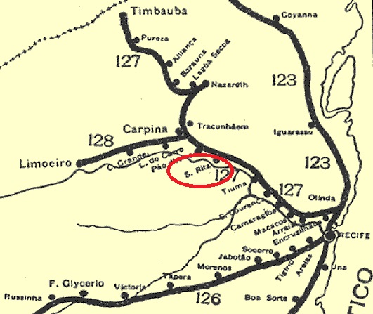
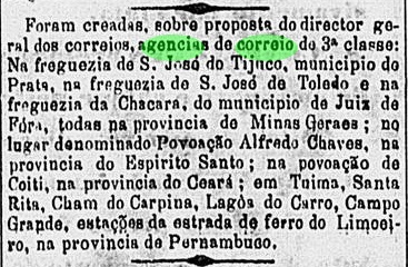
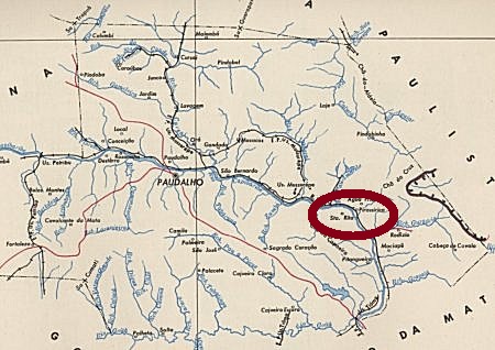
The Santa Rita train station was built in october 1881 by the Estrada de Ferro do Recife ao Limoeiro (Great Western do Brazil), North Line, in the municipality of Pau d’Alho, round 35 km northwest of the province capital Recife. Early in 20th century the station was renamed Pirassirica. In 1950 the railway passed to the Rede Ferroviária do Nordeste, and from 1975 until operation end in 1996, to the Rede Ferroviária Federal SA. Now the station is demolished, but the tracks are still there, in a militar area (estacoesferroviarias.com.br).
The station post office was created in October 1882, as reported by the Rio press:
O Globo, Rio de Janeiro, October 28, 1882
One early cancel is known: SPE-0585a (Coll. José A. Junges) has a double circle with the inscriptions SANTA RITA above and PERNAMO. below. The date of the only found copy (on a Southern Cross issue of 1890) shows SET for September.
IBGE (estacoesferroviarias.com.br)
Anderer Name: Pirassirica
Der Bahnhof Santa Rita train station wurde im Oktober 1881 durch die Estrada de Ferro do Recife ao Limoeiro (Great Western do Brazil), Linie Nord, gebaut und lag im Município von Pau d’Alho, rund 35 km nordwestlich der Provinzhauptstadt Recife entfernt. Im frühen 20. Jahrhundert wurde die Station auf Pirassirica umbenannt. 1950 ging die Bahnklinie in Besitz der Rede Ferroviária do Nordeste über, und von 1975 bis zum Betriebsende 1996 gehörte sie der Rede Ferroviária Federal SA. Nun ist das Gebäude abgerissen, aber die Schiene liegen noch, in einem Militärgebiet (estacoesferroviarias.com.br).
Das Bahnhofspostamt entstand im Oktober 1882, wie die Presse aus Rio berichtet:
O Globo, Rio de Janeiro, 28. Oktober 1882
Ein früher Stempel ist überliefert: SPE-0585a (Samml. José A. Junges) hat einen Doppelkreis mit den Inschriften SANTA RITA oben und PERNAMO. unten. Das einzige vorhandene Exemplar (auf einer Kreuz-des-Südens-Ausgabe von 1890) zeigt in der Mitte SET, für September.
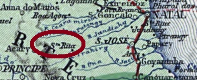
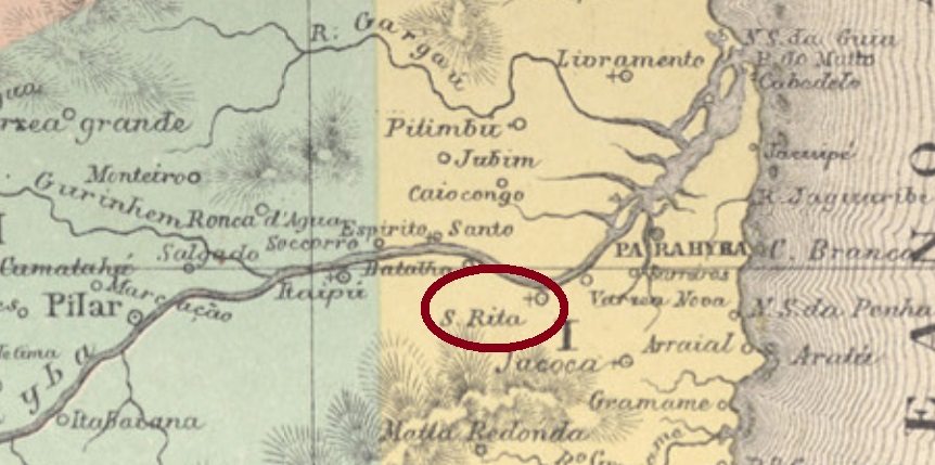
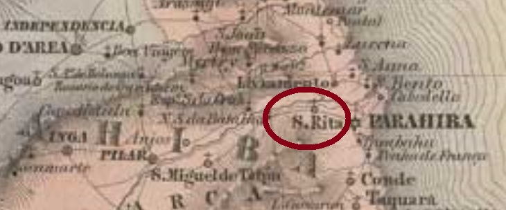
Santa Rita was since February 1839 a freguesia situated ca. 20 km west of the province capital Parahyba (today João Pessoa), behind the actual international airport. In March 1890 it was elevated to a villa in own municipality, and it is a town since December 1924.
The Imperial Mail Register (Tabella das Agencias do Correio do Imperio) of 1885 does not list this post office, but given that a postmark from there was found dated May 1885, it must have opened shortly before. SPB-0270a (Coll. José A. Junges) has a double circle with the inscription STA. RITA DO PARAHYBA above and a diamond ornament below, formed by four small diamonds. Date in the centre. SPB-0270b (Coll. José A. Junges) could be already republican, for it is dated 1892. Within the double circle the inscriptions are now S.RITA above and (PARAHYBA) below, with date in the centre.
Villiers de l’Ile Adam: Carta (…) das Provincias do Rio Grande do Norte e Parahiba, 1848
Anderer Name: Santa Rita do Parahyba
Santa Rita war seit Februar 1839 eine Freguesia der 20 km östlich gelegenen Provinzhauptstadt Parahyba (heute João Pessoa), die heute hinter dem internationalem Flughafen liegt. Im März 1890 wurde sie eine Villa im eigenen Município, und seit Dezember 1924 ist sie eine Stadt.
Im Verzeichnis der kaiserlichen Postämter (Tabella das Agencias do Correio do Imperio) von 1885 sucht man vergebens nach diesem Postamt. Da es aber einen mit Mai 1885 datierten Stempel von dort gibt, muss diese Agentur kurz davor geöffnet haben. SPB-0270a (Samml. José A. Junges) hat einen Doppelkreis mit der Inschrift STA. RITA DO PARAHYBA oben und einem rautenförmigen Ornament unten, das aus vier kleinen Rauten besteht, dazu das Datum in der Mitte. SPB-0270b (Samml. José A. Junges) könnte bereits republikanisch sein, da es aus 1892 kommt: im Doppelkreis lauten die Inschriften nun S.RITA oben und (PARAHYBA) unten, mit Datum in der Mitte.
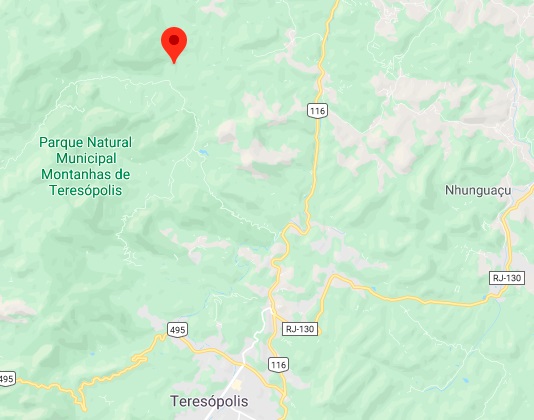
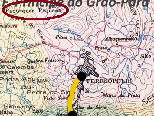
Santa Rachel was a tiny locality in the freguesia of Barra de Santa Rita, municipality of Magé, situated round 120 km north of the empire capital Rio de Janeiro. In May 1892 it was declared a district of the recently founded municipality of Theresopolis and has changed its name twice since then: in December 1938 to Paquequer Pequeno, and in April 1990 to Vale do Paquequer.
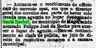
The local post office was created in January 1874, as noticed by the Rio press, but was already closed five months later, according to Paulo Novaes (agenciaspostais.com.br):
Diario do Rio de Janeiro, February 8, 1874
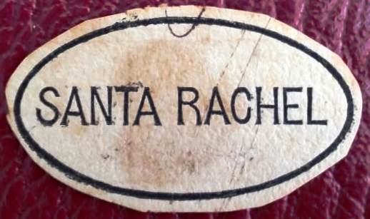
The only postal cancel of Santa Rachel, SRJ-0883a, (Coll. Fuad Ferreira Fo.) must be very rare, given the short operation time of an agency in such a small village:
SRJ-0883a (FF)agenciaspostais.com.br
Santa Rachel war eine kleine Ortschaft der Freguesia von Barra de Santa Rita im Município von Magé, die rund 120 km nördlich der kaiserlichen Hauptstadt Rio de Janeiro entfernt lag. Im Mai 1892 wurde sie ein Distrikt des kurz zuvor gegründeten Município von Theresopolis und hat seitdem den Ortsnamen zweimal gewechselt: im Dezember 1938 zu Paquequer Pequeno und im April 1990 zu Vale do Paquequer.
Das örtliche Postamt entstand im Januar 1874, wie die Presse aus Rio berichtet, wurde aber bereits fünf Monate später wieder geschlossen, laut Paulo Novaes (agenciaspostais.com.br):
Diario do Rio de Janeiro, 8. Februar 1874
Der einzige Poststempel aus Santa Rachel, SRJ-0883a, (Samml. Fuad Ferreira Fo.) muss sehr selten sein, wenn man betrachtet, wie kurz die Betriebszeit einer so kleinen Agentur war:
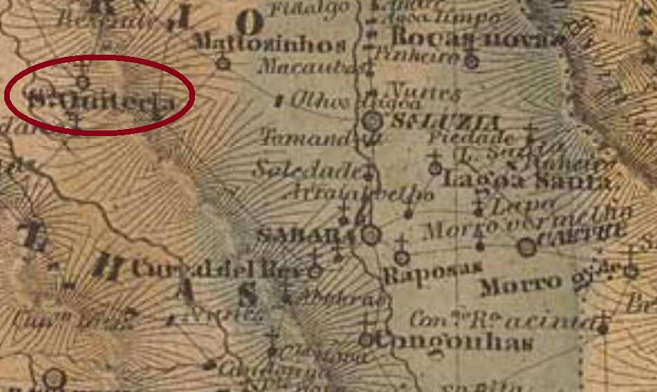
The Santa Quitéria of the Minas Gerais province was originally a district of the municipality of Sabará, created in July 1832 and situated ca. 150 km northwest of the ancient province capital Ouro Preto. In September 1901 it became an own municipality, and has since December 1943 the name Esmeraldas.
Three imperial cancels are known. SMG-2890a was already presented by the RHM catalogue as a pre-philatelic cancel, which would be not exactly correct, if we consider Nova Monteiro’s creation date:
SMG-2890a, RHM P-MG-53
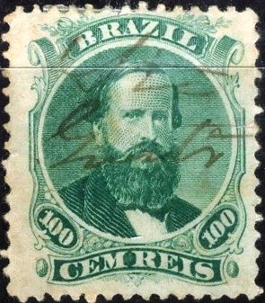
There follows the manuscript cancel SMG-2890b (Coll. Marcio Protzner), which was found on the first D. Pedro issue of 1866 (“black beard”). Sometimes Quiteria is written completely:
SMG-2890b (MP)
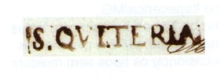
The last imperial cancel, SMG-2890c (Coll. José A. Junges), has a double circle with the inscription SANTA QUITERIA above, and the date in the centre. Found for the period 1888-1890.
Villiers de l’Ile Adam: Carta (…) da Provincia de Minas Geraes, 1849
Santa Quiteria aus der Provinz Minas Gerais war zu Beginn ein Distrikt von Sabará, gegründet im Juli 1832 und ca. 150 km nordwestlich von der ehemaligen Hauptstadt Ouro Preto entfernt. Im September 1901 stieg der Ort zur Villa auf und seit Dezember 1943 heißt er Esmeraldas.
Laut Nova Monteiro (Administrações e Agencias Postaes do Brasil Imperio, in Brasil Filatelico/RJ, 1934-5; Reprint SPP 1994-1999) entstand das örtliche Postamt im September 1845. Da aber sowohl Paula Sobrinho (História Postal de Minas Gerais, Belo Horizonte, 1997) als auch das Verzeichnis der kaiserlichen Postämter (Tabella das Agencias do Correio do Imperio) von 1885 behaupten, dies sei im März 1864 geschehen, war die Agentur wohl zwischendurch geschlossen.
Wir kennen drei Entwertungen aus der Kaiserzeit. SMG-2890a wurde bereits durch den RHM Katalog als ein Vorphila-Stempel vorgestellt. Das stimmt nicht ganz, falls die Datumsangabe von Nova Monteiro über das Postamt stimmt:
SMG-2890a , RHM P-MG-53
Es folgt eine handschriftliche Entwertung: SMG-2890b (Coll. Marcio Protzner) ist auf der ersten D. Pedro-Ausgabe (mit schwarzem Bart) von 1866 zu finden. Das Wort Quiteria wird gelegentlich ausgeschrieben.
SMG-2890b(MP)
Der letzte kaiserliche Stempel, SMG-2890c (Samml. José A. Junges), hat einen Doppelkreis mit der Inschrift SANTA QUITERIA oben, dazu das Datum in der Mitte. Gefunden mit Daten aus dem Zeitraum 1888-1890.
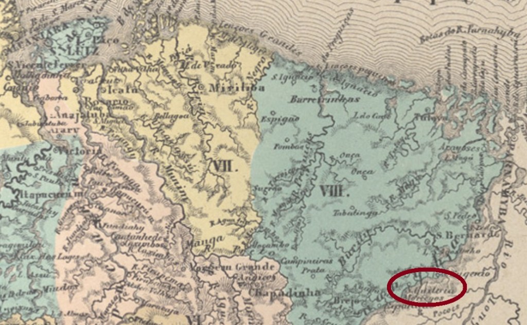
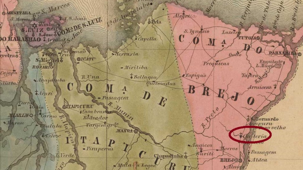
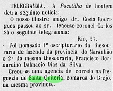
The Santa Quitéria in the Maranhão province was a district of the municipality of Brejo, situated ca. 350 km east of the province capital São Luís. In December 1943 it emancipated as the municipality of Bacuri, but this toponym was apparently not very popular, for five years later the locality was renamed Santa Quitéria do Maranhão.
According to the Postal Report (Relatorio Postal) of 1886, the local post office started in August 1885, but its creation was already in July, as stated by the local press:
Publicador Maranhense, July 28, 1885
No postal cancel from the Empire has been surely identified until now.
Villiers de l’Ile Adam: Carta (…) da Provincia do Maranhão, 1850
Die Santa Quitéria in der Provinz Maranhão war ursprünglich ein Distrikt im Município von Brejo und lag ca. 350 km östlich der Hauptstadt São Luís. Im Dezember 1943 stieg er zum Município von Bacuri auf. Dieser Ortsname war offenbar nicht sehr beliebt, denn fünf Jahre später bekam die Ortschaft den aktuellen Namen Santa Quitéria do Maranhão.
Laut Postbericht (Relatorio Postal) von 1886 startete das örtliche Postamt den Betrieb im August 1885, aber die gesetzliche Gründung fand bereits im Juli statt, wie die Lokalpresse berichtet:
Publicador Maranhense, 28. Juli 1885
Kein Stempel aus der Kaiserzeit konnte sicher dieser Ortschaft zugeordnet werden.
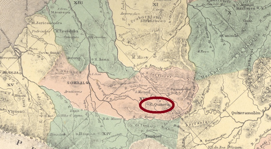
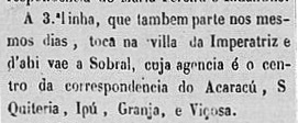
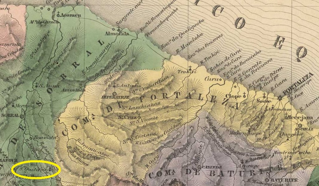
Santa Quitéria was since March 1823 a district of the municipality of Sobral, situated over 200 km southwest of the province capital Fortaleza. In August 1856 it emancipated as a villa.
No postal cancel from the Empire has been surely identified until now.
Villers de l’Ile Adam: Carta (…) da Provincia do Ceará
Santa Quitéria war seit März 1823 ein Distrikt des Município von Sobral und lag über 200 km südwestlich der Provinzhauptstadt Fortaleza entfernt. Er stieg zur Villa im August 1856 auf.
Laut Nova Monteiro (Administrações e Agencias Postaes do Brasil Imperio, in Brasil Filatelico/RJ, 1934-5; Reprint SPP 1994-1999) entstand das örtliche Postamt im August 1866, aber bereits 1861 gab es eine Stafettenlinie der Post zwischen Imperatriz und Santa Quitéria, wie die Regionalpresse berichtet:
Cearense, 2. August 1861
Kein Stempel aus der Kaiserzeit konnte dieser Ortschaft sicher zugeordnet werden.
Carta da Republica dos Estados Unidos do Brazil, 1892
Text update of September 5, 2020
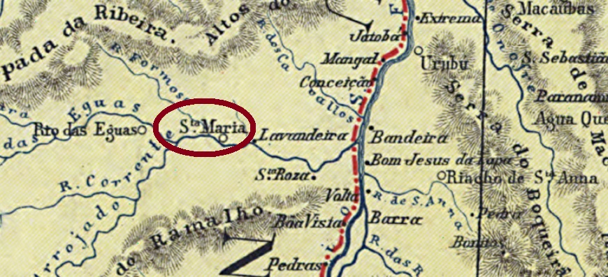
The history of this locality is closely related to the neighbour locality Rio das Éguas (RBA-0605). It began in May 1866, when Santa Maria da Victoria was founded as a freguesia of Rio das Éguas, situated over 850 km west of the province capital Salvador da Bahia. In June 1880 the situation inverted: Santa Maria ascended to a villa, of which Rio das Éguas was a district. Six years later, in May 1886 the original status quo returned, remaining so for the next two years. In May 1888 Santa Maria da Victoria recovered its municipality definitively, and became the town of Santa Maria in June 1909, which recovered the original toponym in 1943.
The exact date for the creation of the local post office has still to be discovered, but given that it was not yet listed in theImperial Mail Register (Tabella das Agencias do Correio do Imperio) of 1885, and that in 1889 the postal agent was replaced (see note below), it must have taken place between those years:
Diario da Bahia, June 12, 1889
One early post cancel was found: SBA-0662a (Coll. Alexandre Andrade) has a double circle with the inscriptions S. MARIA DA VICTORIA above and (BAHIA) below, dated 1908 at the centre.
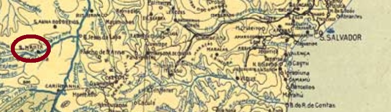
Arthur D. Ribeiro: Mappa do Estado da Bahia, 1925
Textaktualisierung am 5. September 2020
Die Geschichte dieser Ortschaft ist eng mit der des Nachbarorts Rio das Éguas (RBA-0605) verknüpft. Es begann im Mai 1866, als Santa Maria als eine Freguesia von Rio das Éguas gegründet wurde, die über 850 km westlich der Provinzhauptstadt Salvador da Bahia entfernt lag. Im Juni 1880 war die Lage umgekehrt: Santa Maria steig zur Villa auf, und Rio das Éguas wurde ein Distrikt davon. Sechs Jahre später, im Mai 1886, kehrte der ursprüngliche statusquo zurück, und so verblieb es für die nächsten zwei Jahre. Im Mai 1888 erhielt Santa Maria da Victoria ihre Eigenständigkeit endgültig wieder und wurde im Juni 1909 die Stadt Santa Maria. Seit 1943 ist der ursprüngliche Ortsname Santa Maria da Vitória wieder offiziell.
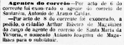
Das exakte Datum für die Entstehung des Postamts wurde noch nicht ermittelt. Da aber dieses noch nicht im Verzeichnis der kaiserlichen Postämter (Tabella das Agencias do Correio do Imperio) von 1885 aufgelistet war, und der Postangestellte bereits 1889 ersetzt wurde (s. unten), muss diese Agentur zwischen beiden Jahren eröffnet gewesen sein:
Diario da Bahia, 12. Juni 1889
Eine frühe postalische Entwertung wurde gefunden: SBA-0662a (Samml. Alexandre Andrade) hat einen Doppelkreis mit den Inschriften S. MARIA DA VICTORIA oben und (BAHIA) unten, datiert 1908 in der Mitte.