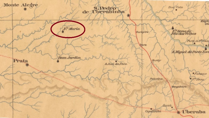
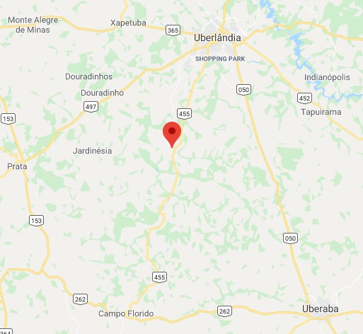
This is another rare locality that never developed from the district status. It was founded in August 1864 within the municipality of Monte Alegre (today Monte Alegre de Minas), situated over 650 km west from the early province capital Ouro Preto, quite near the Goiás border. Oddly enough, in spite of the Uberaba in the name, it apparently never belonged to this community. In August 1888 it changed to São Pedro de Uberabinha, which was renamed Uberabinha in March 1891, and since October 1929 it is a district of Uberlândia, having switched the toponym to the actual Miraporanga in December 1943. This tupi word means beautiful people.
According to Paula Sobrinho (História Postal de Minas Gerais, Belo Horizonte, 1997), the local post office was created in February 1884. No imperial post cancel has appeared until now.
Google Maps
Andere Namen: Santa Maria, Miraporanga (1943)
Diese ist wieder eine der seltenen Ortschaften, die niemals den Distrikt-Status hinter sich gelassen haben. Sie wurde im August 1864 im Município von Monte Alegre (heute Monte Alegre de Minas) gegründet und lag über 650 km westlich der alten Provinzhauptstadt Ouro Preto entfernt, nah an der Grenze zu Goiás. Und obwohl der Ort Uberaba von Beginn an im Ortsnamen war, seltsamerweise gehörte Santa Maria niemals direkt dazu. Im August 1888 wechselte die Ortschaft zu São Pedro de Uberabinha, dessen Name im März 1891 als Uberabinha vereinfacht wurde, und seit Oktober 1929 ist sie ein Distrikt von Uberlândia. Der Ortsname wechselte im Dezember 1943 zu Miraporanga, ein Wort der Tupi-Sprache, das hübsche Menschen bedeutet.
Laut Paula Sobrinho (História Postal de Minas Gerais, Belo Horizonte, 1997) gibt es ein Postamt dort seit Februar 1884. Bisher ist kein Poststempel aus der Kaiserzeit aufgetaucht.
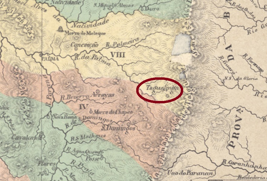
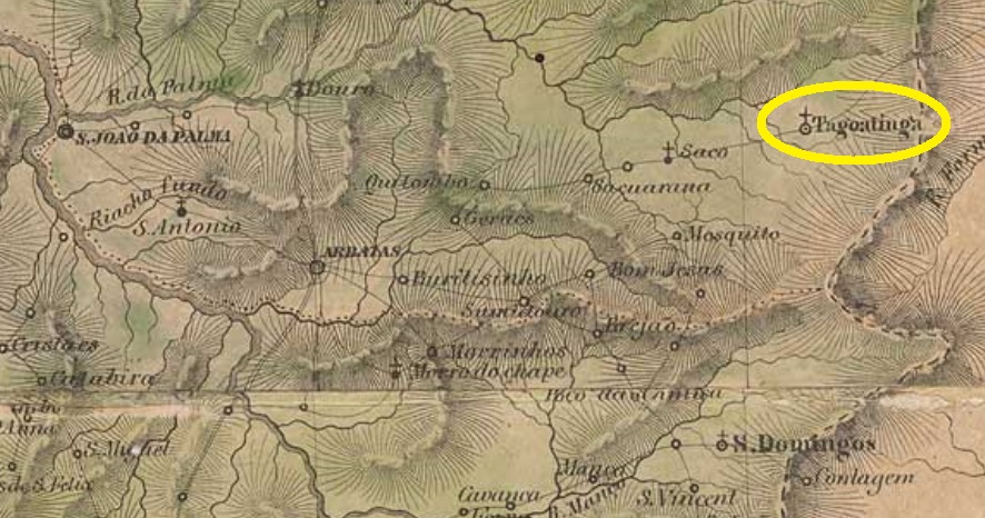
Taguatinga is a tupi word that means white clay. Santa Maria de Taguatinga was since October 1840 a freguesia of São Domingos, situated round 850 km northeast of the ancient province capital Goyaz (now Goiás Velho). In November 1855 it ascended to a villa, but between 1863 and 1868 it was a district of the municipality of Arraias. In 1948 the toponym was simplified to Taguatinga, and since October 1988 this municipality belongs to the newly created Tocantins State.
Only one early post cancel has appeared by now, most probably not the first one. SGO-0251b (image from the internet) has a double circle with the inscription S.M. DE TAGUATINGA and date of 1909 in the centre.
Villiers de l’Ile Adam: Carta (…) da Provincia de Goyaz, 1849
Taguatinga ist ein Begriff der Tupi-Sprache, der weisser Ton bedeutet. Santa Maria de Taguatinga war seit Oktober 1840 eine Freguesia von São Domingos und lag rund 850 km nordöstlich der ehemaligen Provinzhauptstadt Goyaz (heute Goiás Velho) entfernt. Im November 1855 stieg sie zur Villa auf, wurde dennoch zwischen 1863 und 1868 wieder ein Distrikt, diesmal vom Município von Arraias. 1948 wurde der Ortsname zu Taguatinga vereinfacht, und seit Oktober 1988 gehört dieser Município zum neu gegründeten Staat Tocantins.
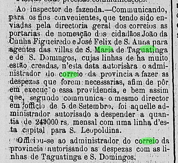
Laut Verzeichnis der kaiserlichen Postämter (Tabella das Agencias do Correio do Imperio) von 1885 entstand das örtlich Postamt in 1874, was durch die Amtspresse bestätigt werden kann:
Correio Official de Goyaz, 18. November 1874
Nur ein früher Poststempel ist bisher aufgetaucht, höchstwahrscheinlich nicht der früheste: SGO-0251b (Abb. aus dem Internet) hat eine Doppelkreis mit der Inschrift S.M. DE TAGUATINGA, dazu ein Datum aus 1909 in der Mitte.
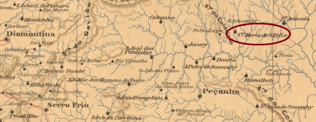
Santa Maria de São Felix was a district of the municipality of Pessanha, founded in June 1876 and situated almost 400 km north of the province capital Ouro Preto. In September 1923 it emancipated as the Villa of Santa Maria do Suassuhy. Suassuhy (since 1948 written Suaçuí) is a river of the surroundings whose tupi-guarani name means river of big wild game.
According to Paula Sobrinho (História Postal de Minas Gerais, Belo Horizonte, 1997), the local post office was created in August 1881. The only early cancel which was found until now, SMG-2880a (Coll. José A. Junges) has a double circle with the inscription S.MARIA DE S. FELIX above and a diamond ornament below, which consists of four little diamonds. The dates in the centre were found for the period 1888ff-1901.
Raphael Lorenzeto de Abreu
Santa Maria de São Felix war ein im Juni 1876 gegründeter Distrikt der Gemeinde Pessanha, der fast 400 km nördlich der ehemaligen Provinzhauptstadt Ouro Preto entfernt lag. Im September 1923 stieg die Ortschaft zur Villa von Santa Maria do Suassuhy auf. Suassuhy (seit 1948 Suaçuí geschrieben) ist ein Fluss der Umgebung, dessen Tupi-guarani Name Fluss der großen Jagdtiere bedeutet.
Laut Paula Sobrinho (História Postal de Minas Gerais, Belo Horizonte, 1997) entstand das örtliche Postamt im August 1881. Bisher wurde nur ein früher Stempel gefunden: SMG-2880a (Samml. José A. Junges) hat einen Doppelkreis mit der Inschrift S.MARIA DE S. FELIX oben und einem rautenförmigen Ornament unten, das aus vier kleinen Rauten besteht. Die Daten in der Mitte wurden für den Zeitraum 1888ff-1901 gefunden.
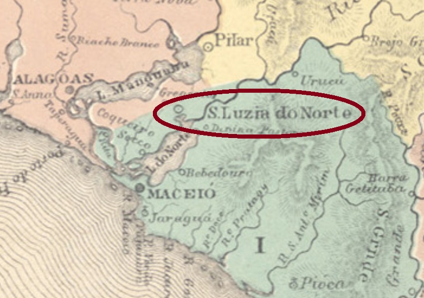
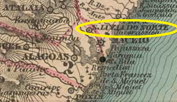
Santa Luzia do Norte was originally a district of the former province capital Alagoas (today: Marechal Deodoro), situated ca. 40 km north, near the Mundaú Lagoon. In December 1830 it was elevated to a Villa in own municipality, which became a town in July 1915. In March 1938 it lost the town status, to remain as a district of Rio Largo, ascending again as a município only in August 1962.
The only early postal cancel of this locality which was found to date, SAL-0240a (Coll. José A. Junges), might be already republican, for it is dated 1899: a double circle with the inscriptions S.LUZIA DO NORTE above and (ALAGOAS) below, with the date in the centre.
Villiers de l’Ile Adam: Carta (…) das Provincias de Pernambuco, Alagoas e Sergipe, 1848
Santa Luzia do Norte war ursprünglich ein Distrikt der ehemaligen Provinzhauptstadt Alagoas (heute: Marechal Deodoro) und lag 40 km weiter nördlich, nah am Mundaúsee. Im Dezember 1830 wurde daraus eine Villa im eigenen Município, die im Juli 1915 den Stadtstatus erhielt. Dieser ging allerdings im März 1938 verloren, Santa Luzia do Norte wurde ein Distrikt von Rio Largo und erlangte erst im August 1962 den höheren Status wieder.
Laut Nova Monteiro (Administrações e Agencias Postaes do Brasil Imperio, in Brasil Filatelico/RJ, 1934-5; Reprint SPP 1994-1999) eröffnete das örtliche Postamt im September 1855, obwohl das Verzeichnis der kaiserlichen Postämter (Tabella das Agencias do Correio do Imperio) von 1885 das Jahr 1860 dafür angibt. Auf der anderen Seite schreibt Aldo Cardoso (Contribuição para a História dos Correios de Alagoas, Maceió, 1969), dass bereits 1834 der Steuereinnehmer des Orts als Postbeamter fungierte, obwohl damals keine Postagentur vorhanden war.
Der bisher einzige frühe Poststempel für diese Ortschaft könnte bereits republikanisch sein, da er 1899 datiert ist: SAL-0240a (Samml. José A. Junges) hat einen Doppelkreis mit den Inschriften S.LUZIA DO NORTE oben und (ALAGOAS) unten, dazu das Datum in der Mitte.
Carta da Republica dos Estados Unidos do Brazil, 1892
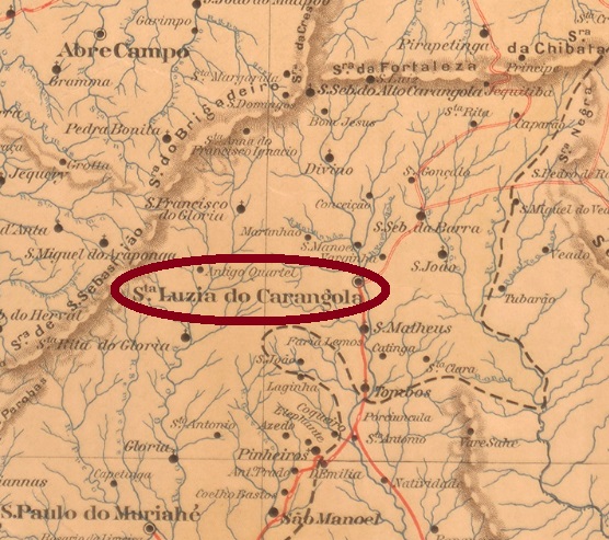
Other name: Carangola
Santa Luzia do Carangola was since October 1860 a district of the municipality of São Paulo de Muriahé, situated on the Carangola River, over 270 km east of the old provincial capital Ouro Preto. In November 1878 it emancipated as a villa in own municipality, and since October 1881 it is the town of Carangola.
According to Paula Sobrinho (História Postal de Minas Gerais, Belo Horizonte, 1997), the local post ofice was created in April 1881, which is confirmed by the Bahia press, despite of the wrong toponym:
O Monitor, Bahia, May 3, 1881
Two early cancels werde found, both showing the name which officially disappeared in October 1881. SMG-2685a (Coll. José A. Junges) has a double circle with the inscription S.LUZIA DO CARANGOLA above and a diamond ornament below, whose four sides are open. The dates in the centre present years between 1885 and 1892, sometimes the day or month indication is substituted by two horizontal bars. SMG-2685b (Coll. Dieter Kerkhoff) might be already republican, for the recorded dates are between 1894 and 1908. It is similar to its predecessor, but here there is an inscription below: (MINAS).
Minas Geraes, 1910
Anderer Name: Carangola
Santa Luzia do Carangola war seit Oktober 1860 ein Distrikt des Municipio von São Paulo de Muriahé und lag am Fluss Carangola River, über 270 km östlich der alten Provinzhauptstadt Ouro Preto entfernt. Im November 1878 wurde daraus eine Villa in eigenem Municipio, und seit Oktober 1881 ist es die Stadt Carangola.
Laut Paula Sobrinho (História Postal de Minas Gerais, Belo Horizonte, 1997) entstand das örtliche Postamt im April 1881, was durch die Presse aus Bahia bestätigt wird, wobei hier der Ortsname fehlerhaft ist:
O Monitor, Bahia 3. Mai 1881
Zwei frühe Poststempel wurden gefunden, beide zeigen noch den Ortsnamen, der offiziell seit Oktober 1881 verschwunden sein sollte. SMG-2685a (Samml. José A. Junges) hat einen Doppelkreis mit der Inschrift S.LUZIA DO CARANGOLA oben und einem rautenförmigen Ornament unten, dessen vier Seiten offen sind. Die Daten in der Mitte weisen Jahrgänge von 1885 bis 1892 auf, manchmal wird die Tages- oder Monatsangabe durch zwei waagerechte Balken ersetzt. SMG-2685b (Samml. Dieter Kerkhoff) könnte bereits republikanisch sein, da die bisher ermittelten Jahrgänge zwischen 1894 und 1908 liegen. Er ist ähnlich wie der Vorgänger, aber hier lautet die untere Inschrift: (MINAS).
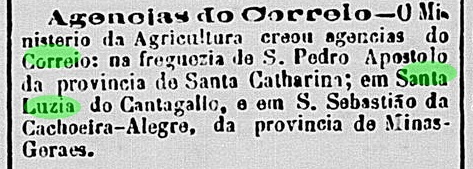
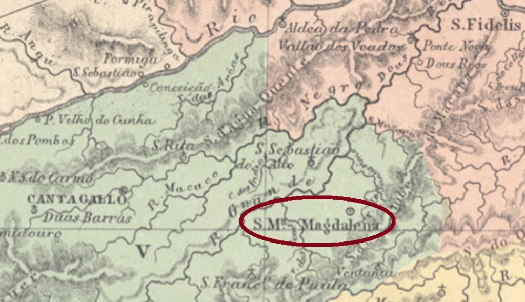
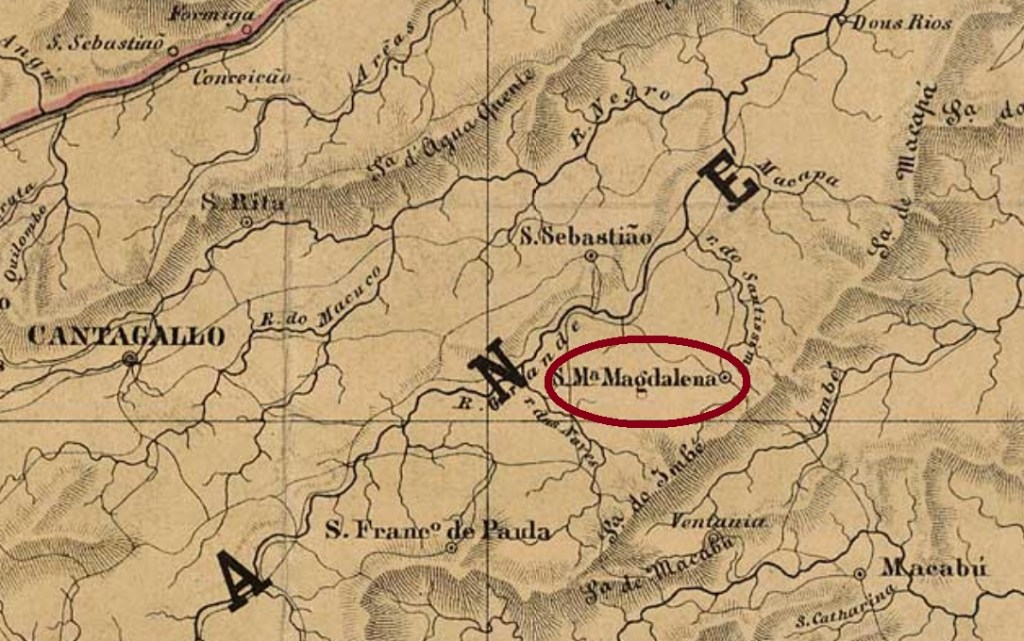
The freguesia of Santa Maria Magdalena was founded in September 1855 in the municipality of Cantagallo, round 250 km northeast of the imperial capital Rio de Janeiro. In October 1861 it emancipated as a villa, and since July 1890 it is a town.
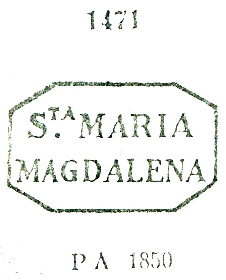
The first postal cancel is a well known one, already presented by Paulo Ayres (Catálogo de Carimbos Brasil-Império, S. Paulo, 1937, 1942) under #1471. SRJ-0880a occurs in black and blue and was used until ca. 1876:
SRJ-0880a, P.A. 1471
It was followed by SRJ-0880b (Coll. José A. Junges): a double circle with the inscription S. M. MAGDALENA, also in black and blue, whose inner dates show years between 1877 and 1894.
Almanak Laemmert, 1866
Die Freguesia von Santa Maria Magdalena wurde im September 1855 im Município von Cantagallo gegründet und lag rund 250 km nordöstlich der kaiserlichen Hauptstadt Rio de Janeiro entfernt. Im Oktober 1861 wurde sie eine eigenständige Villa, und seit Juli 1890 ist sie eine Stadt.
Laut Nova Monteiro (Administrações e Agencias Postaes do Brasil Imperio, in Brasil Filatelico/RJ, 1934-5; Reprint SPP 1994-1999) entstand das örtliche Postamt im Oktober 1855. Aureo G. Santos (Agências de Correio Criadas e Suprimidas 1851,1855,1856 e 1857, in Brasil Filatélico 181, Rio de Janeiro) liefert uns den Originaltext dazu:
Aureo G. Santos (op.cit.)
Der erste Poststempel ist ein alter Bekannter, bereits durch Paulo Ayres (Catálogo de Carimbos Brasil-Império, S. Paulo, 1937, 1942) unter Nr. 1471 vorgestellt. SRJ-0880a kommt in schwarz und blau vor und wurde bis ca. 1876 benutzt:
SRJ-0880a, P.A. 1471
Ihm folgte SRJ-0880b (Samml. José A. Junges): ein Doppelkreis mit der Inschrift S. M. MAGDALENA, auch in schwarz und blau zu finden, dessen Daten in der Mitte aus dem Zeitraum 1877-1894 kommen.
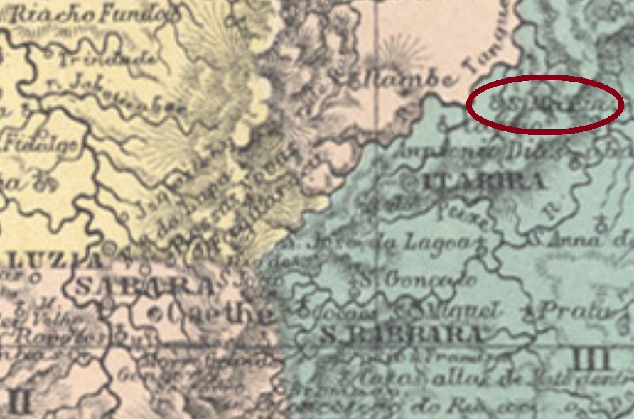
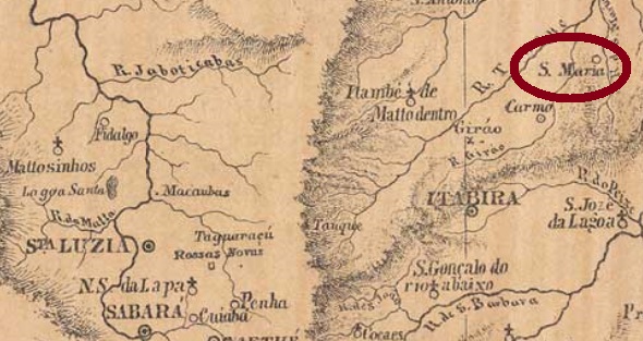
The freguesia of Nossa Senhora do Rosário de Santa Maria was founded in September 1870 in the muncipality of Conceição, round 170 km north of the ancient province capital Ouro Preto. In the following year it passed as a district to the municipality of Itabira. The toponym was simplified to Santa Maria de Itabira in December 1938, which is an own municipality since 1943.
According to Paula Sobrinho (História Postal de Minas Gerais, Belo Horizonte, 1997), the local post office was created in January 1876. Two imperial cancels were found. SMG-2875a (Coll. José A. Junges) has a double circle with the inscriptions S . MARIA above and (MINAS) below. The only copy has a date of 1889 in the centre. SMG-3715a (image from the internet) is similar to before, but here the inscription below is (MUNo. DE ITABIRA). Dates in the centre between 1886 and 1897.
Mappa da Provincia de Minas Geraes, 1873
Die Freguesia von Nossa Senhora do Rosário de Santa Maria wurde im September 1870 im Município von Conceição gegründet und lag rund 170 nördlich der ehemaligen Provinzhauptstadt Ouro Preto entfernt. Im darauf folgenden Jahr ging sie als Distrikt zum Município von Itabira über. Im Dezember 1938 wurde der Ortsname als Santa Maria de Itabira vereinfacht, und seit 1943 ist es ein eigenständiger Município.
Laut Paula Sobrinho (História Postal de Minas Gerais, Belo Horizonte, 1997) entstand das örtliche Postamt im Januar 1876. Zwei Abstempelungen der Kaiserzeit wurden gefunden. SMG-2875a (Samml. José A. Junges) hat einen Doppelkreis mit den Inschriften S . MARIA oben und (MINAS) unten. Das einzige bekannte Exemplar hat Datum von 1889 in der Mitte. SMG-3715a (Abb. aus dem Internet) ist ähnlich wie sein Vorgänger, nun lautet hier die untere Inschrift (MUNo. DE ITABIRA). Daten in der Mitte zwischen 1886 und 1897.
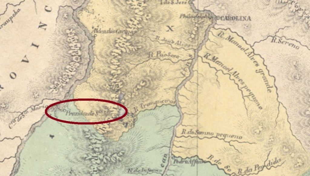
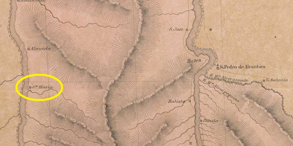
This locality began as a prision“to make the navigation safer”, which was built in November 1859 on the east bank of the Araguaya River, ca. one thousand km north of the ancient province capital Goyaz (now Goiás Velho). In July 1874 it was elevated to a freguesia, in the following year it was already a villa, which changed the name in March 1931 to Santa Maria do Araguaya, a couple of weeks before becoming a town. Since December 1943 it is the municipality of Araguacema, which since 1988 belongs to the recently created Tocantins State.
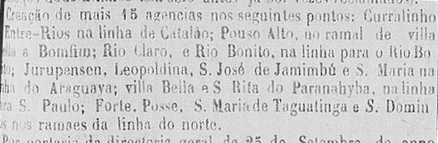
We have found two different years for the creation of the post office. While the Imperial Mail Register (Tabella das Agencias do Correio do Imperio) of 1885 sustains it took place in 1870, there is a note published by the Correio Official de Goyaz of September 1875 referring to a recent post office creation in Santa Maria do Araguaya:
Correio Official de Goyaz, September 15, 1879
No imperial post cancel has appeared to date.
Villiers de l’Ile Adam: Carta (…) da Provincia de Goyaz, 1849
Andere Namen: Araguaya, Araguacema (1943)
Diese Ortschaft entstand aus einem Gefängnis, im November 1859 am Ostufer des Flusses Araguaya errichtet, “um die Schifffahrt sicherer zu machen”. Sie lag ca. tausend km nördlich der ehemaligen Provinzhauptstadt Goyaz (heute: Goiás Velho) entfernt. Im Juli 1874 wurde daraus eine Freguesia und ein Jahr später schon eine Villa, die im März 1931 einen Namenswechsel zu Santa Maria do Araguaya vollzog, ein Paar Wochen bevor sie eine Stadt wurde. Seit Dezember 1943 ist es der Município von Araguacema, der seit 1988 dem neu gegründeten Bundesstaat Tocantins gehört.
Zwei verschiedene Gründungsjahre fürs örtliche Postamt wurden gefunden. Während das Verzeichnis der kaiserlichen Postämter (Tabella das Agencias do Correio do Imperio) von 1885 die Agentur ab 1870 auflistet, notiert der Correio Official de Goyaz im September 1875 die Neugründung eines Postamts in Santa Maria do Araguaya:
Correio Official de Goyaz, 15. September 1875
Bisher war von dort kein Poststempel aus dem Kaiserreich zu sehen.
Arthur D. Ribeiro: Mappa do Estado de São Paulo, 1925
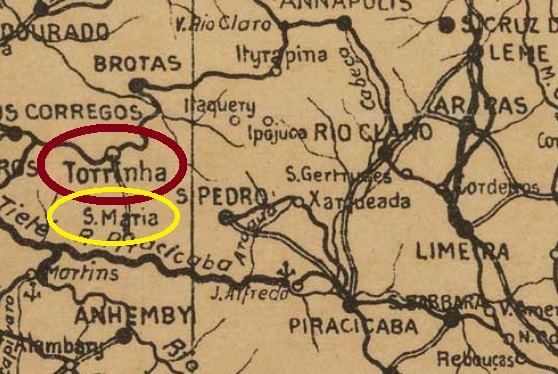
Other names: Santa Maria de Piracicaba, Tupancy, Santa Maria da Serra
Santa Maria was since February 1881 a district of the newly founded municipality of São Pedro, situated on the north bank of the Piracicaba River, over 200 km northwest of the provincial capital São Paulo. In November 1944 the toponym changed to Tupancy (which means Mother of God in tupi), and since February 1959 it is the municipality of Santa Maria da Serra.
According to the Imperial Mail Register (Tabella das Agencias do Correio do Imperio) of 1885, the local post office was created in 1882. Only one imperial post cancel could be safely identified. SSP-1300a (Coll. José A. Junges) has a double circle with the inscription SANTA MARIA S. PAULO and the date inside. The sole known copy was applied on a D.Pedro issue of 1876, whose date is unfortunately illegible.
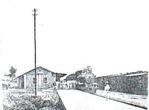
Santa Maria station, 1918 (Photo: Filemon Peres, apud estacoesferroviarias.com.br)
Other name : Torrinha
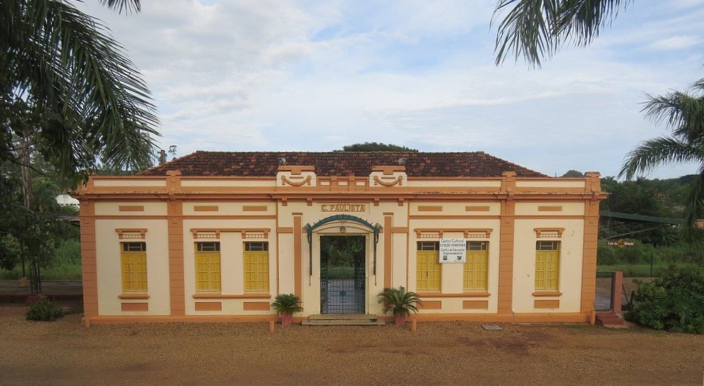
The Santa Maria train station was built in September 1886 by the Estrada de Ferro Rio Clarense, Jahú Branch, in the municipality of Brotas, over 20 km north of the district of Santa Maria de Piracicaba. In 1888 the railway control passed to the Rio Claro Railway. In 1893 or 1894, the station was renamed Torrinha, giving its name later to the municipality created in November 1922. Between 1892 and 1971 the railway belonged to the Cia. Paulista de Estradas de Ferro, and from then on until the end of activities in 1998, to the FEPASA. The station house was rebuilt in neoclassical style in 1924, now it hosts the local office of the SEBRAE enterprise (estacoesferroviarias.com.br).
The station post office must have been created by May 1887, for at that time a post agent was first mentioned by the regional press:
Correio Paulistano, May 10, 1887
No imperial cancel for the train station has been found until now.
In 2016. (Photo: Daniel Gentili, apud estacoesferroviarias.com.br)
Andere Namen: Santa Maria de Piracicaba, Tupancy, Santa Maria da Serra
Santa Maria war seit Februar 1881 ein Distrikt des damals neu gegründeten Município von São Pedro und lag am Nordufer des Flusses Piracicaba, über 200 km nordwestlich der Provinzhauptstadt São Paulo entfernt. Im November 1944 wechselte der Orstname zu Tupancy, ein Begriff der Tupi-Sprache, der Mutter Gottes bedeutet. Seit Februar 1959 ist es der Município von Santa Maria da Serra.
Laut Verzeichnis der kaiserlichen Postämter (Tabella das Agencias do Correio do Imperio) von 1885 entstand 1882 das örtliche Postamt. Nur ein Stempel der Kaiserzeit konnte gefunden werden: SSP-1300a (Samml. José A. Junges) hat einen Doppelkreis mit der Inschrift SANTA MARIA S. PAULO, dazu das Datum in der Mitte. Das einzige bekannte Exemplar wurde auf einer D.-Pedro-Ausgabe von 1876 gefunden, dessen Datum leider unleserlich ist.
Bahnhof Santa Maria, 1918 (Foto: Filemon Peres, apud estacoesferroviarias.com.br)
Anderer Name : Torrinha
Der Bahnhof Santa Maria wurde im September 1886 durch die Estrada de Ferro Rio Clarense, Jahú-Abzweigung gebaut und lag im Município von Brotas, über 20 km nördlich der Ortschaft Santa Maria de Piracicaba entfernt. 1888 wechselte die Bahnlinie zur Gesellschaft Rio Claro Railway. Die Station wurde 1893 oder 1894 Torrinha umbenannt und gab den Namen an den Município weiter, der im November 1922 entstand. Zwischen 1892 und 1971 gehörte die Bahnstrecke der Cia. Paulista de Estradas de Ferro, und von 1971 bis Betriebsende 1998, der FEPASA. Das Bahnhaus wurde 1924 im feierlichen, neoklassischen Stil neu gebaut und heute beherbergt den Regionalsitz der Firma SEBRAE (estacoesferroviarias.com.br).
Das Bahnhofspostamt wurde wohl bis Mai 1887 ins Leben gerufen, denn zu dieser Zeit wurde erstmals ein Postangestellter durch die Regionalpresse bekannt gemacht:
Correio Paulistano, 10. Mai 1887
Bisher wurde kein Stempel der Kaiserzeit für den Bahnhof gefunden.
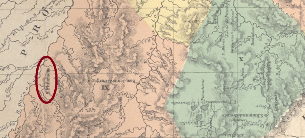
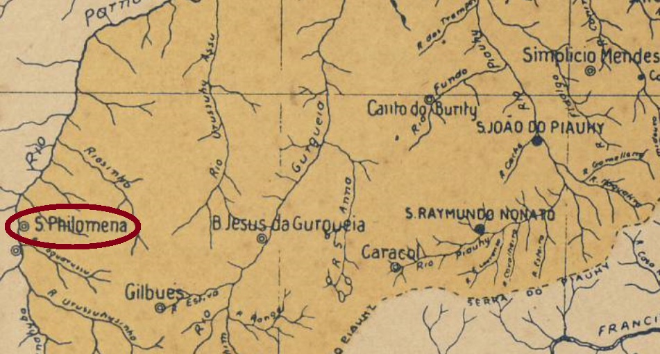
The district of Santa Philomena was founded in January 1856 in the municipality of Parnaguá, situated on the east bank of the Parnaíba River at the border to Maranhão, over 800 km southwest of the recently created province capital Teresina. It was twice elevated to a villa, in 1865 and in 1873, for in-between it returned as a Parnaguá district in 1871. Now it is the municipality of Santa Filomena.
Nova Monteiro (Administrações e Agencias Postaes do Brasil Imperio, in Brasil Filatelico/RJ, 1934-5; Reprint SPP 1994-1999) writes a creation date of November 1864 for the postal office. Since the Imperial Mail Register (Tabella das Agencias do Correio do Imperio) of 1885lists this agency as established in 1883, it was probably closed in the meantime. We found one imperial cancel of the second period: SPI-0205a (Coll. José A. Junges) has a double circle with the inscription S.PHILOMENA above. The sole copy is dated 1885 in the centre.
Arthur D. Ribeiro: Mappa do Estado do Piauhy, 1924
Der Distrikt von Santa Philomena wurde im Januar 1856 im Município von Parnaguá gegründet und lag am Ostufer des Flusses Parnaíba River an der Grenze zu Maranhão, über 800 km südwestlich der damals neu gegründeten Provinzhauptstadt Teresina entfernt. Er stieg zweimal zur Villa auf, 1865 und 1873, und inzwischen (1871) war er wieder Distrikt von Parnaguá. Nun heißt der Município Santa Filomena.
Nova Monteiro (Administrações e Agencias Postaes do Brasil Imperio, in Brasil Filatelico/RJ, 1934-5; Reprint SPP 1994-1999) schreibt ein Entstehungsdatum im November 1864 für dieses Postamt. Da aber dasVerzeichnis der kaiserlichen Postämter (Tabella das Agencias do Correio do Imperio) von 1885 hierfür das Jahr 1883 angibt, war die Agentur wohl in der Zwischenzeit geschlossen. Für die zweite Betriebsperiode wurde ein kaiserlicher Stempel gefunden: SPI-0205a (Samml. José A. Junges) hat einen Doppelkreis mit der Inschrift S.PHILOMENA oben. Das einzig gesichtete Exemplar trägt ein Datum aus 1885 in der Mitte.