Categories
Carimbologia S

Santa Maria, Rio Grande do Sul (SRS-0400)

Atlas do Imperio do Brasil, 1868

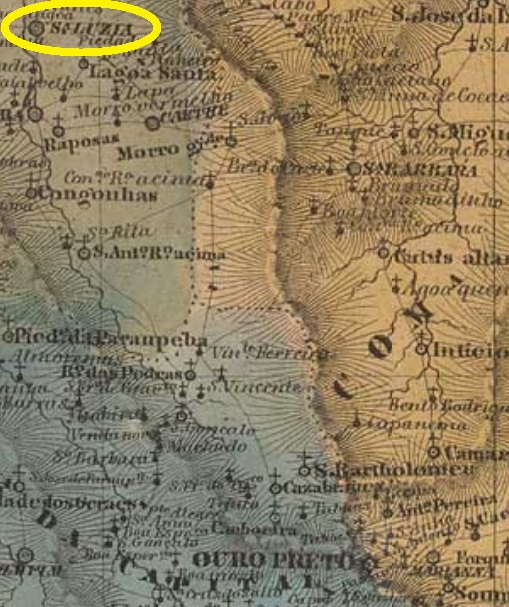
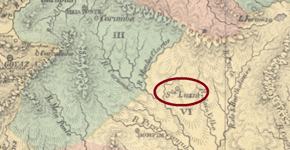
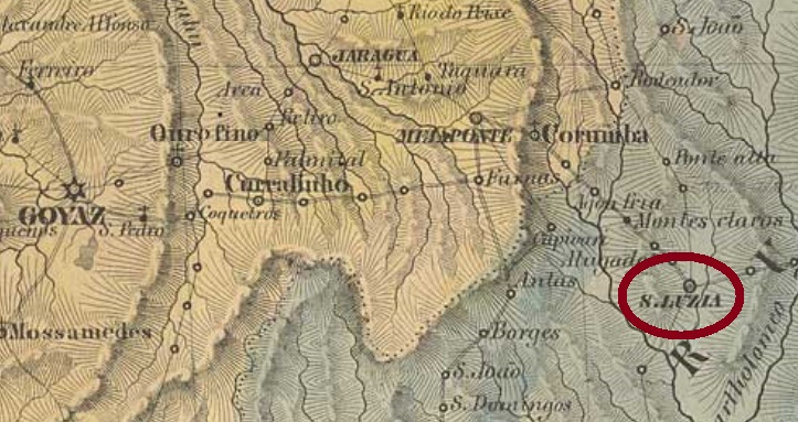
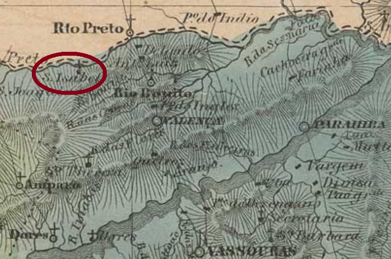
The district of Santa Maria da Bocca do Monte was founded in November 1837 in the municipality of Rio Pardo, round 300 km west of the province capital Porto Alegre. In December 1857 it was elevated to a villa, which became a town in April 1876. Since December 1936 it has officially the simplified name of Santa Maria.

According to Nova Monteiro (Administrações e Agencias Postaes do Brasil Imperio, in Brasil Filatelico/RJ, 1934-5; Reprint SPP 1994-1999), the local post office was created in October 1831. The Imperial Mail Register (Tabella das Agencias do Correio do Imperio) of 1885 lists this agency from 1832 on, probably when it was installed.

The first imperial cancel is a pre-philatelic one: SRS0400a was already presented by the RHM Catálogo Enciclopédico under P-RS-25:

SRS-0400a, RHM P-RS-25

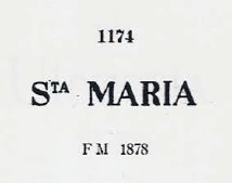
It was followed by SRS-0400b, which occurs in black, red and blue between ca.1866 and ca. 1878, as shown by Paulo Ayres (Catálogo de Carimbos Brasil-Império, S. Paulo, 1937, 1942) under #1174:

SRS-0400b, P.A. 1174

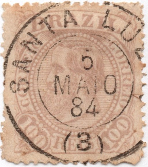
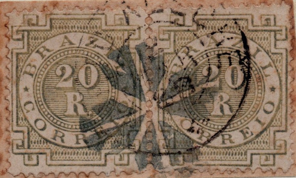
SRS-0400c (Coll. Karlheinz Wittig) has a double circle with the inscription SANTA MARIA above and the date in the centre. Found in black, blue, lilac, red and violet on objects used 1877-1890. Sometimes the year line is missing.

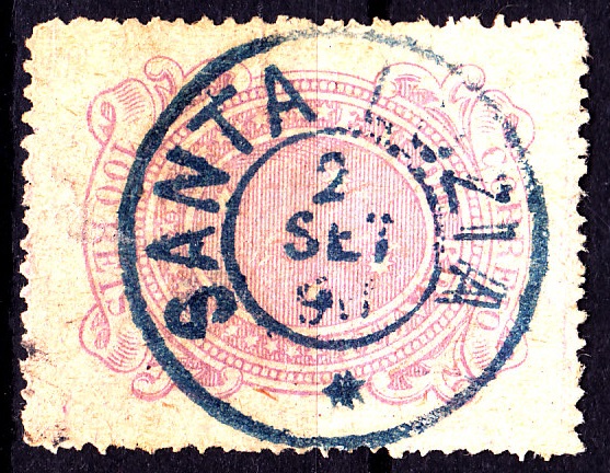
The last cancel could be already republican: SRS-0400d (Coll. Dieter Kerkhoff) has a double circle with the inscriptions SANTA MARIA above and (S. PEDRO DO SUL) below. Dates in the centre found for the period 1892-1896.

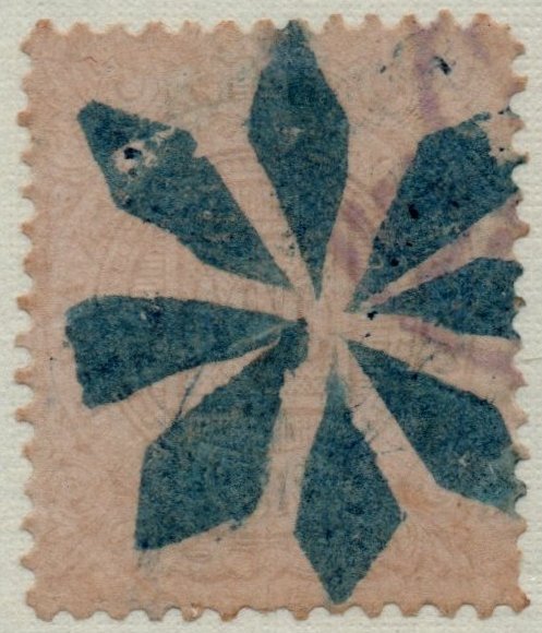
In the eighties three mute cancels were also used (all coll. José A. Junges):

1885ff (JJ), BPA # 849?
1885ff (JJ),P.Ayres #600? BPA #3938?
1888 (JJ), BPA #4010?

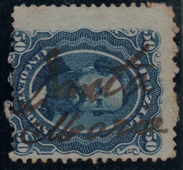
One manuscript cancellation is also known, used 1866ff (Coll. José A. Junges):

1866ff (JJ)
Villiers de l’Ile Adam: Carta (…) da Provincia de São Pedro do Sul, 1847

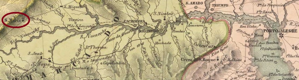
Der Distrikt von Santa Maria da Bocca do Monte wurde im November 1837 im Município von Rio Pardo gegründet und lag rund 300 km westlich der Provinzhauptstadt Porto Alegre entfernt. Im Dezember 1857 stieg er zur Villa auf und wurde im April 1876 eine Stadt. Seit Dezember 1936 ist der vereinfachte Name Santa Maria offiziell.

Laut Nova Monteiro (Administrações e Agencias Postaes do Brasil Imperio, in Brasil Filatelico/RJ, 1934-5; Reprint SPP 1994-1999) entstand das örtliche Postamt im Oktober 1831. Das Verzeichnis der kaiserlichen Postämter (Tabella das Agencias do Correio do Imperio) von 1885 listet die Agentur von 1832 an, dann wurde sie wohl in Betrieb genommen.

Der erste Stempel stammt noch aus der Vorphila-Zeit: SRS0400a wurde bereits durch das RHM Catálogo Enciclopédico unter P-RS-25 vorgestellt:

SRS-0400a, RHM P-RS-25

Ihm folgte SRS-0400b, der in schwarz, rot und blau zwischen ca. 1866 und ca. 1878 vorkommt, wie durch Paulo Ayres (Catálogo de Carimbos Brasil-Império, S. Paulo, 1937, 1942) unter Nr. 1174 abgebildet:

SRS-0400b, P.A. 1174

SRS-0400c (Samml. Kalrheinz Wittig) hat einen Doppelkreis mit der Inschrift SANTA MARIA oben und dem Datum in der Mitte. Gefunden in schwarz, blau, lila, rot und violett auf Objekten im Zeitraum 1877-1890. Manchmal fehlt die Jahresangabe.

Der letzte frühe Stempel könnte bereits republikanisch sein: SRS-0400d (Samml. Dieter Kerkhoff) hat einen Doppelkreis mit den Inschriften SANTA MARIA oben und (S. PEDRO DO SUL) unten. Die Daten in der Mitte wurden für den Zeitraum 1892-1896 gefunden.

In den 80er Jahren des 19. Jahrhunderts sind auch drei stumme Stempel zu sehen (alle Samml. José A. Junges):

1885ff (JJ), BPA Nr. 849?
1885ff (JJ), P. Ayres Nr. 600?, BPA Nr. 3938?
1888 (JJ), BPA Nr. 4010?

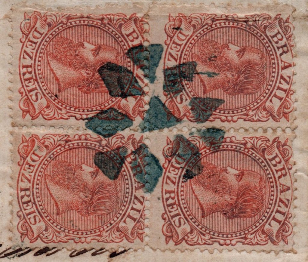
Eine handschriftliche Entwertung sei noch erwähnt, die auf einer D. Pedro-Ausgabe von 1866 vorkommt (Samml. José A. Junges):

1866ff (JJ)
Categories
Carimbologia S

Santa Margarida, Minas Gerais (SMG-2870)

Atlas do Imperio do Brasil, 1868

The district of Santa Margarida was founded in June 1859 in the municipality of Ponte Nova, over 180 km east of the province capital Ouro Preto. After that, it changed three times to other municipalities, as long as these were established: in November 1877 to São Simão, in September 1881 to Manhuassú, and in December 1938 to Matipó. Finally, in December 1948 it emancipated as the actual municipality of Santa Margarida.

According to Paula Sobrinho (História Postal de Minas Gerais, Belo Horizonte, 1997), the local post office was created in June 1881. This is confirmed by the regional press:

A Actualidade, June 18, 1881

The only known imperial cancel, SMG-2780a (Coll. Marcio Protzner) shows a double circle with the inscriptions S.MARGARIDA above and (MINAS) below. The dates in the centre were found for the period 1885-1888.

Minas Geraes e Espirito Santo, 1873

Der Distrikt von Santa Margarida wurde im Juni 1859 im Município von Ponte Nova gegründet und lag gut 180 km östlich der Provinzhauptstadt Ouro Preto entfernt. Danach wechselte er dreimal seine Zugehörigkeit, je nachdem weitere Municípios ins Leben gerufen wurden: im November 1877 zu São Simão, im September 1881 zu Manhuassú und im Dezember 1938 zu Matipó. Schließlich stieg Santa Margarida im Dezember 1948 zum eigenen Município auf.

Laut Paula Sobrinho (História Postal de Minas Gerais, Belo Horizonte, 1997) entstand das örtliche Postamt im Juni 1881, was durch die Regionalpresse bestätigt wird:

A Actualidade, 18. Juni 1881

Der einzige überlieferte Poststempel der Kaiserzeit, SMG-2780a (Samml. Marcio Protzner) zeigt einen Doppelkreis mit den Inschriften S.MARGARIDA oben und (MINAS) unten. Die Daten in der Mitte wurden für den Zeitraum 1885-1888 gefunden.

Categories
Carimbologia S

Santa Mafalda (train station/Bahnhof), Rio de Janeiro (SRJ-1893)

Mappa do Estado de Minas Geraes, 1910

The Santa Mafalda train station was built after 1882 by the Estrada de Ferro Rio das Flores in the municipality of Parahyba do Sul, over 180 km north of the capital Rio de Janeiro. From 1910 until operation end in 1965, the railroad belonged to the E.F. Central do Brasil. Now the station house has been demolished, and the tracks are removed (estacoesferroviarias.com.br).

According to Paulo Novaes (agenciaspostais.com.br), the station post office was created in August 1889. Given that regular mail service started only two weeks before the end of the Empire, early cancels must be very rare:

Diario de Noticias, November 1, 1889

No imperial cancel has been seen until now.

Almanak Laemmert, 1892

Der Bahnhof Santa Mafalda wurde nach 1882 durch die Estrada de Ferro Rio das Flores im Município von Parahyba do Sul gebaut und lag gut 180 km nördlich der kaiserlichen Hauptstadt Rio de Janeiro entfernt. Von 1910 bis Betriebsende 1965 gehörte die Bahnlinie der E. F. Central do Brasil. Nun ist das Bahnhofsgebäude abgerissen, und die Schienen wurden entfernt (estacoesferroviarias.com.br).

Laut Paulo Novaes (agenciaspostais.com.br) entstand das Bahnhofspostamt im August 1889. Da aber der reguläre Postverkehr erst zwei Wochen vor Ende des Kaiserreichs startete, müssen frühe Poststempel sehr selten sein:

Diario de Noticias, 1. November 1889

Kein Stempel der Kaiserzeit konnte bisher gesehen werden.

Categories
Carimbologia S

Santa Luzia, Sergipe (SSE-0155)

Atlas do Imperio do Brasil, 1868

Other names: Inajaroba, Santa Luzia do Itanhy

The district of Santa Luzia was reported as early as in 1629, subordinated to Estancia and situated over 80 km southwest from the later province capital São Cristóvão. In February 1835 it was elevated to a villa in own municipality, which in December 1943 was renamed Inajaroba. This name was apparently not very popular, for five years later, in December 1948, the toponym was changed again, to the actual Santa Luzia do Itanhy. Itanhy is allegedly the indigenous name for the Real River in the surroundings.

According to Nova Monteiro (Administrações e Agencias Postaes do Brasil Imperio, in Brasil Filatelico/RJ, 1934-5; Reprint SPP 1994-1999), the local post office was created in March 1863.

For actual information about the different Santa Luzia cancels see also:

Santa Luzia: Differentiation / Unterscheidung

Carta da Republica dos Estados Unidos do Brazil, 1892

Andere Namen: Inajaroba, Santa Luzia do Itanhy

Der Distrikt von Santa Luzia wurde bereits 1629 urkundlich erwähnt, er gehörte zur Gemarkung Estancia und lag über 80 km südwestlich der späteren Provinzhauptstadt São Cristóvão entfernt. Im Februar 1835 wurde daraus eine Villa im eigenen Município, die im Dezember 1943 zu Inajaroba umbenannt wurde. Dieser Name war scheinbar nicht sehr beliebt, den fünf Jahre später, im Dezember 1948, wurde der Ortsname abermals geändert, zum aktuellen Santa Luzia do Itanhy. Itanhy ist angeblich der indianische Name für den nah gelegenen Fluss Real.

Laut Nova Monteiro (Administrações e Agencias Postaes do Brasil Imperio, in Brasil Filatelico/RJ, 1934-5; Reprint SPP 1994-1999) entstand das örtliche Postamt im März 1863.

Für aktuelle Angaben über die Problematik der Santa Luzia-Stempel siehe auch:https://carimbologia.car.blog/2020/08/03/santa-luzia-differentiation-unterscheidung/

Categories
Carimbologia S

Santa Luzia do Sabugy, Paraíba (SPB-0225)

Mappa dos estados do Ceará, Rio Grande do Norte e Parahyba, 1910

Print edition update (October 19, 2021)

Other names: Santa Luzia, Sabugi

The district of Santa Luzia do Sabugy was created in October 1857 in the municipality of Patos, under 300 km west of the province capital Parahyba (today: João Pessoa). Sabugy/Sabugi is a small river in the surroundings. In November 1871 the locality was elevated to a villa, and in November 1938 it had the name simplified to Santa Luzia. Five years later, in December 1943, the municipality was called Sabugi, but the old toponym Santa Luzia returned in June 1947.

According to the Postal Report (Relatorio Postal) of 1886, the local post office was created in November 1872. In the meantime, a postmark of the imperial period has appeared: SPB-0225a (Coll. Fuad Ferreira Fo.) was not shown in Carimbologia S1. Therefore, we present it here:

SPB-0225a (FF), 1886

For actual information about the different Santa Luzia cancels see also:

Santa Luzia: Differentiation / Unterscheidung

Arthur D. Ribeiro: Estado da Parahyba, 1923

Printausgabe-Aktualisierung v. 19. Oktober 2021

Andere Namen: Santa Luzia, Sabugi

Der Distrikt von Santa Luzia do Sabugy wurde im Oktober 1857 im Município von Patos, rund 300 km westlich der Provinzhauptstadt Parahyba (heute: João Pessoa) gegründet. Der Sabugy/Sabugi ist ein kleiner Fluss der Umgebung. Im November 1871 stieg die Ortschaft zur Villa auf, die im November 1938 den vereinfachten Namen Santa Luzia bekam. Fünf Jahre später, im Dezember 1943, hieß der Município Sabugi, aber der alte Ortsname Santa Luzia kehrte im Juni 1947 zurück.

Laut dem Postbericht (Relatorio Postal) von 1886, entstand das örtliche Postamt im November 1872. Inzwischen ist ein Poststempel der Kaiserzeit aufgetaucht: SPB-0225a (Samml. Fuad Ferreira Fo.) wurde nicht in Carimbologia S1 abgebildet. Daher stellen wir ihn hier vor:

SPB-0225a (FF), 1886

Für aktuelle Angaben über die Problematik der Santa Luzia-Stempel siehe auch:https://carimbologia.car.blog/2020/08/03/santa-luzia-differentiation-unterscheidung/

Categories
Carimbologia S

Santa Luzia, Minas Gerais (SMG-2860) – Santa Luzia do Sabará, Minas Gerais (SMG-3709)

Atlas do Imperio do Brasil, 1868

Other name: Santa Luzia do Rio das Velhas

The district of Santa Luzia do Rio das Velhas (or simply Santa Luzia) was founded in February 1724 through Royal License (Alvará Régio), subordinated to Sabará and situated round 120 km northwest of the later province capital Ouro Preto. In March 1847 it ascended to a villa, but lost this status in May 1850. Only in April 1856 it was elevated again to villa, to become a town in May 1858. Since September 1924 the municipality bears the simplified official name of Santa Luzia. In spite of the absence of an official record establishing the toponym Santa Luzia de Sabará, this name was also found in the press and legal documents as early as 1879, also appearing in postal cancels.

At least three dates for the creation of the postal office were found. Paula Sobrinho (História Postal de Minas Gerais, Belo Horizonte, 1997) writes January 8, 1842, while the ImperialMailRegister (Tabella das Agencias do Correio do Imperio) of 1885 lists this agency from 1853 on, and both Post Reports (Relatórios Postais) of 1860 and 1886 register the September 17, 1858. If we assume that all dates are correct, the office was closed at least twice within the period 1842-1858.

The sole cancel found for this Santa Luzia until now is certainly not the earliest one, and its attribution has still to be confirmed, but given that it is the most common among all Santa Luzia cancellations, it should be applicable to the biggest locality with this name. SMG-2860b (Coll. José A. Junges) has a double circle with the inscription SANTA LUZIA above and a (3) below. The dates in the centre were found for the period 1882-1889. One cancel for Santa Luzia de Sabará is also known: SMG-3709a (Coll. Karlheinz Wittig) exists in black and turquoise and consists of a double circle with the inscription SANTA LUZIA DO SABARÁ above and a four-winged leaflet ornament below. Used with dates 1887-1893.

For actual information about the different Santa Luzia cancels see also:

Santa Luzia: Differentiation / Unterscheidung

Villiers de l’Ile Adam: Carta (…) da Provincia de Minas Geraes, 1849

Anderer name: Santa Luzia do Rio das Velhas

Der Distrikt von Santa Luzia do Rio das Velhas (oder einfach Santa Luzia) wurde im Februar 1724 durch königliche Verfügung (Alvará Régio) im Bezirk Sabará gegründet und lag rund 120 km nordwestlich der späteren Provinzhauptstadt Ouro Preto entfernt. Im März 1847 stieg er zur Villa auf, dennoch ging dieser Status im Mai 1850 verloren. Erst im April 1856 wurde Santa Luzia wieder eine Villa, und im Mai 1858 eine Stadt. Seit September 1924 trägt der Município offiziell den vereinfachten Ortsnamen Santa Luzia. Obwohl bisher keine gesetzliche Grundlage für den Namen Santa Luzia de Sabará zu finden war, erschien ab 1879 diese Bezeichnung in der Presse und sogar in amtlichen Dokumenten, später auch auf Poststempeln.

Mindestens drei Daten fürs Postamt sind überliefert. Paula Sobrinho (História Postal de Minas Gerais, Belo Horizonte, 1997) schreibt den 8. Januar 1842, während das Verzeichnis der kaiserlichen Postämter (Tabella das Agencias do Correio do Imperio) von 1885 diese Agentur mit Entstehungsjahr 1853 auflistet, und zwei Post-Jahresberichte (Relatórios Postais), von 1860 und 1886, nennen dafür den 17. September 1858. Wenn wir davon ausgehen, dass alle Daten richtig sind, wurde das örtliche Postamt im Zeitraum 1842-1858 mindestens zweimal geschlossen.

Der einzige bisher gefundene Poststempel aus der Kaiserzeit für diese Ortschaft ist sicher nicht der früheste. Seine Zuordnung ist ebenso wenig zweifelsfrei, aber da er mit Abstand die am häufigsten vorkommende Abstempelung darstellt, sollte diese zur größten Ortschaft namens Santa Luzia gehören. SMG-2860b (Samml. José A. Junges) hat einen Doppelkreis mit der Inschrift SANTA LUZIA oben und eine (3) unten. Die Daten in der Mitte weisen auf den Zeitraum 1882-1889 auf. Auch für Santa Luzia de Sabará ist ein früher Stempel überliefert: SMG-3709a (Samml. Karlheinz Wittig) kommt in schwarz und türkis vor und besteht aus einem Doppelkreis mit der Inschrift SANTA LUZIA DO SABARÁ oben und einem Ornament unten, das aus vier Blättchen in Kreuzform formiert wird. Benutzt im Zeitraum 1887-1893.

Für aktuelle Angaben über die Problematik der Santa Luzia-Stempel siehe auch:

Santa Luzia: Differentiation / Unterscheidung

Categories
Carimbologia S

Santa Luzia, Goiás (SGO-0210)

Atlas do Imperio do Brasil, 1868

Santa Luzia was a district founded by gold miners in September 1759, situated over 380 km east of the former province capital Goyaz (today: Goiás Velho). In April 1834 it was elevated to a villa in own municipality, and in October 1867 it ascended to a town. Since December 1943 it is called the municipality of Luziânia.

Nova Monteiro (Administrações e Agencias Postaes do Brasil Imperio, in Brasil Filatelico/RJ, 1934-5; Reprint SPP 1994-1999) lists this post office with creation date in March 1829, but the Imperial Mail Register (Tabella das Agencias do Correio do Imperio) of 1885 states it took place in 1853. Possibly this agency was closed for a while, in the meantime. From the first period we have SGO-0210a (RHM- Catálogo Enciclopédico), a cancel which was found on Bull’s Eyes:

SGO-0210a (RHM)

For actual information about the different Santa Luzia cancels see also:

Santa Luzia: Differentiation / Unterscheidung

Villiers de l’Ile Adam: Carta (…) da Provincia de Goyaz, 1849

Santa Luzia war ein Distrikt, durch Goldsucher im September 1759 gegründet, der über 380 km östlich der ehemaligen Provinzhauptstadt Goyaz (heute: Goiás Velho) entfernt lag. Im April 1834 stieg er zur Villa im eigenen Município auf, die sich ab Oktober 1867 eine Stadt nennen durfte. Seit Dezember 1943 ist es der Município von Luziânia.

Nova Monteiro (Administrações e Agencias Postaes do Brasil Imperio, in Brasil Filatelico/RJ, 1934-5; Reprint SPP 1994-1999) listet dises Postamt mit Entstehungsdatum im  März 1829 auf, aber im Verzeichnis der kaiserlichen Postämter (Tabella das Agencias do Correio do Imperio) aus 1885 liest man das Jahr 1853. Wahrscheinlich war die Agentur in der Zwischenzeit mal geschlossen. Aus der ersten Betriebszeit haben wir den Stempel SGO-0210a (RHM- Catálogo Enciclopédico), der auch auf Ochsenaugen zu finden ist:

SGO-0210a (RHM)

Für aktuelle Angaben über die Problematik der Santa Luzia-Stempel siehe auch:

Santa Luzia: Differentiation / Unterscheidung

Categories
Carimbologia S

Santa Luzia: Differentiation / Unterscheidung

The Santa Luzia cancels represent a similar challenge like Santa Cruz (see also https://wordpress.com/block-editor/post/carimbologia.car.blog/1552). We have also here small post offices with a scarce number of cancels and postal objects that make a clear differentiation quite hard. Let’s begin by presenting all SANTA LUZIA agencies – without complements e.g. „…do Carangola“ – from the oldest to newest one (in parentheses the local population, as referred by the Imperial Mail Guide – Guia Postal do Imperio – of 1880):

  • Santa Luzia/Goyaz (SLGO): agency of 1829 and/or 1853 (6.071)
  • Santa Luzia/Minas Gerais (SLMG): agency of 1843 and/or 1853 and/or 1858 (21.478), also called SL de Sabará or SL do Rio das Velhas
  • Santa Luzia/Sergipe (SLSE): agency of 1863 (4.194)
  • Santa Luzia/Parahyba do Norte (SLPB): agency of 1872 (3.964)

Die Stempel aus Santa Luzia stellen ein ähnliches Problem als die aus Santa Cruz dar (siehe auch https://wordpress.com/block-editor/post/carimbologia.car.blog/1552). Auch hier haben wir mit kleineren Postämtern zu tun, aus denen wenige Stempel und Ganzsachen vorhanden sind, was eine Unterscheidung schwerer macht. Zunächst stellen wir alle SANTA LUZIA-Postämter vor – ohne Zusätze wie z.B. „…do Carangola“, in chronologischer Folge (in Klammern die Einwohnerzahl, laut “Guia Postal do Imperio” aus 1880):

  • Santa Luzia/Goyaz (SLGO): Agentur aus 1829 und/oder 1853 (6.071)
  • Santa Luzia/Minas Gerais (SLMG): Agentur aus 1843 und/oder 1853 und/oder 1858(21.478), auch SL de Sabará oder SL do Rio das Velhas genannt.
  • Santa Luzia/Sergipe (SLSE): Agentur aus 1863 (4.194)
  • Santa Luzia/Parahyba do Norte (SLPB): Agentur aus 1872 (3.964)

And now for the cancel types / Und nun zu den verschiedenen Stempeln:

(Catálogo Enciclopédico-RHM)

a) attributed by the RHM Catálogo Enciclopédico of 1999 and by Henrique B. Ferreira  (Catálogo ilustrado dos carimbos sobre os olhos-de-boi, Porto Alegre, 2017) as SLGO, for its similarity with other cancels of the Goyaz province. Used 1843ff. / Vom RHM “Catálogo Enciclopédico” (S. Paulo, 1999) und auch von Henrique B. Ferreira (“Catálogo ilustrado dos carimbos sobre os olhos-de-boi”, Porto Alegre, 2017) als SLGO identifiziert, durch die Ähnlichkeit mit anderen Goyaz-Stempeln der Zeit.

(Coll. José A. Junges)

 b) used 1882-1889. Possibly SLMG, for due to relatively high number of copies it should belong to the biggest locality. / Benutzt 1882-1889. Möglicherweise SLMG, denn bei der relativ hohen Zahl an Beispielen dürfte der Stempel der größten Gemeinde zugeordnet sein.

(Coll. Karlheinz Wittig)

c) only one copy of 1890. Possibly SLPB or SLSE. / Nur ein Exemplar aus 1890 vorhanden. Möglicherweise SLPB oder SLSE.

What next? To identify all cancels, we ask for images of further examples showing letters, dates, destinations, stamps, different colours or even undiscovered cancels. Every hint may be useful. Please at least 300 dpi. Images can be sent to jm-karlsruhe@web.de. Thank you!/ Nächster Schritt: Um alle Stempel bestimmen zu können, benötigen wir Bilder von weiteren Marken, Briefen, Zielorten, Farben, oder auch von unbekannten Stempeln. Jedes Bild hilft, bitte mit mindestens 300 dpi Auflösung. Alle Bilder sollen dann an jm-karlsruhe@web.de versendet werden. Vielen Dank!

Categories
Carimbologia S

Santa Leopoldina, Espírito Santo (SES-0170)

Ch. Krauss: Mappa da Provincia do Espirito Santo, 1865

Other names: Cachoeiro de Santa Leopoldina, Porto Cachoeiro

See also Colônia Leopoldina (R. Koester: Carimbologia XII)

Santa Leopoldina was a former European colony, founded in 1856 by 60 swiss immigrants and situated round 60 km northwest of the provincial capital Victoria. Further settlers from Germany, Luxemburg and Austria joined the swiss families in the next decades, and the locality was elevated to the villa of Cachoeiro de Santa Leopoldina in April 1884. Six years later, already in the republic, it became the town of Porto Cachoeiro, but in December 1943 the old name Santa Leopoldina returned to remain until today.

There are three different dates for the creation of the local post office. According to the Imperial Mail Register (Tabella das Agencias do Correio do Imperio) of 1885, it took place in 1878, while R. Koester (Carimbologia XII) asserts the March 18, 1879, and Paulo Novaes (agenciaspostais.com.br) states another date: April 14, 1881. Last one can be confirmed by the Rio press:

Jornal do Commercio, Rio de Janeiro, April 14, 1881

Possibly the agency was closed in-between. One imperial cancel is known: SES-0170a (Coll. José A. Junges) occurs in black and blue and has a double circle with the inscription SANTA LEOPOLDINA above and a diamond ornament below, formed by four small diamonds. The dates in the centre were found for the period 1885-1890.

Provincia do Espirito Santo, 1873

Andere Namen: Cachoeiro de Santa Leopoldina, Porto Cachoeiro

Siehe auch Colônia Leopoldina (R. Koester: Carimbologia XII)

Santa Leopoldina war ursprünglich eine europäische Kolonie, die 1856 durch 60 Einwanderer aus der Schweiz gegründet wurde und rund 60 km nordwestlich der Provinzhauptstadt Victoria entfernt lag. In den folgenden Jahrzehnten kamen weitere Siedler aus Deutschland, Luxemburg und Österreich dazu, und im April 1884 wurde aus der Ortschaft die Villa von Cachoeiro de Santa Leopoldina. Sechs Jahre später, schon in der Republik, stieg die Villa zur Stadt Porto Cachoeiro auf, aber im Dezember 1943 kehrte der alte Name Santa Leopoldina zurück und blieb bis heute.

Fürs örtliche Postamt wurden drei verschiedene Gründungsdaten gefunden. Laut Verzeichnis der kaiserlichen Postämter (Tabella das Agencias do Correio do Imperio) von 1885 fand es 1878 statt, während R. Koester (Carimbologia XII) das Datum 18. März 1879 schreibt, und Paulo Novaes (agenciaspostais.com.br) seinerseits für den 14. April 1881 plädiert. Letzteres kann durch die Presse aus Rio bestätigt werden:

 Jornal do Commercio, Rio de Janeiro, 14. April 1881

Womöglich war die Agentur zwischendurch geschlossen. Ein Stempel der Kaiserzeit ist bekannt: SES-0170a (Samml. José A. Junges), in schwarz und blau vorkommend, hat einen Doppelkreis mit der Inschrift SANTA LEOPOLDINA oben und einem rautenförmigen Ornament unten, das aus vier kleinen Rauten besteht. Die Daten in der Mitte stammen aus dem Zeitraum 1885-1890.

Categories
Carimbologia S

Santa Izabel do Rio Preto, Rio de Janeiro (SRJ-0875)

Atlas do Imperio do Brasil, 1868

The district of Santa Izabel do Rio Preto was created in October 1851 in the municipality of Valença, over 170 km northwest of the empire capital Rio de Janeiro. This status quo has remained until today, a remarkable steadiness in a changeful country.

According to Nova Monteiro (Administrações e Agencias Postaes do Brasil Imperio, in Brasil Filatelico/RJ, 1934-5; Reprint SPP 1994-1999), the local post office was created in May 1853. This can be confirmed by the Rio press:

Diario do Rio de Janeiro, June 14, 1853

Five different early cancels were found. The first of them, SRJ-0875a, has been already presented by Paulo Ayres (Catálogo de Carimbos Brasil-Império, S. Paulo, 1937, 1942) under #1593 and was used from the beginning until at least 1866:

SRJ-0875a, P.A. 1593

It was followed by SRJ-0875b (Coll. José A. Junges): a double circle with the inscription S. I. DO RIO PRETO, and date in the centre. Copies found for 1883 and 1884. SRJ-0875c (image from the internet) has a double circle with the inscription S. IZABEL DO RIO PRETO above and a diamond ornament below whose four sides are open, else than dates in the centre. Found in black and blue on objects dated 1886-1889. SRJ-0875d (Coll. José A. Junges) is similar to the former, but here the S is inverted, the DO-letters are smaller, and there is no ornament below. A single exemplar found, dated 1889. SRJ-0875e (agenciaspostais.com.br) has a double circle with the inscription S. IZABEL DO RIO PRETO above and a cross-like ornament below, with date in the centre. Found on objects used between 1889 and 1898.

Villiers de l’Ile Adam: Carta (…) da Provincia do Rio de Janeiro, 1847

Der Distrikt von Santa Izabel do Rio Preto wurde im Oktober 1851 im Município von Valença gegründet und lag über 170 km nordwestlich der Reichshauptstadt Rio de Janeiro entfernt. Dieser Status ist bis heute geblieben, eine bemerkenswerte Regularität in einem Land mit wechselvoller Geschichte.

Laut Nova Monteiro (Administrações e Agencias Postaes do Brasil Imperio, in Brasil Filatelico/RJ, 1934-5; Reprint SPP 1994-1999) entstadt das örtliche Postamt im Mai 1853. Dies kann durch die Presse aus Rio bestätigt werden:

Diario do Rio de Janeiro, 14. Juni 1853

Fünf verschiedene Poststempel aus der Kaiserzeit sind überliefert. Der erste davon, SRJ-0875a, wurde bereits durch Paulo Ayres (Catálogo de Carimbos Brasil-Império, S. Paulo, 1937, 1942) unter Nr.1593 vorgestellt und war vom Betriebsanfang bis mindestens 1866 in Gebrauch:

SRJ-0875a, P.A. 1593

Ihm folgte SRJ-0875b (Samml. José A. Junges): ein Doppelkreis mit der Inschrift S. I. DO RIO PRETO und Datum in der Mitte. Beispiele für 1883 und 1884 sind vorhanden. SRJ-0875c (Abb. aus dem Internet) hat einen Doppelkreis mit der Inschrift S. IZABEL DO RIO PRETO oben und einem rautenförmigen Ornament unten, dessen vier Seiten offen sind, dazu Datum in der Mitte. Gefunden in schwarz und blau auf Objekten mit Daten 1886-1889. SRJ-0875d (Samml. José A. Junges) ist ähnlich wie sein Vorgänger, nun hier ist der Buchstabe S spiegelverkehrt, das Wort DO ist kleiner, und die Verzierung unten ist verschwunden. Das einzig gesichtete Exemplar ist mit 1889 datiert. SRJ-0875e (agenciaspostais.com.br) hat einen Doppelkreis mit der Inschrift S. IZABEL DO RIO PRETO oben und einem kreuzförmigen Ornament unten, dazu Datum in der Mitte. Gefunden auf Objekten, die zwischen 1889 und 1898 datiert sind.