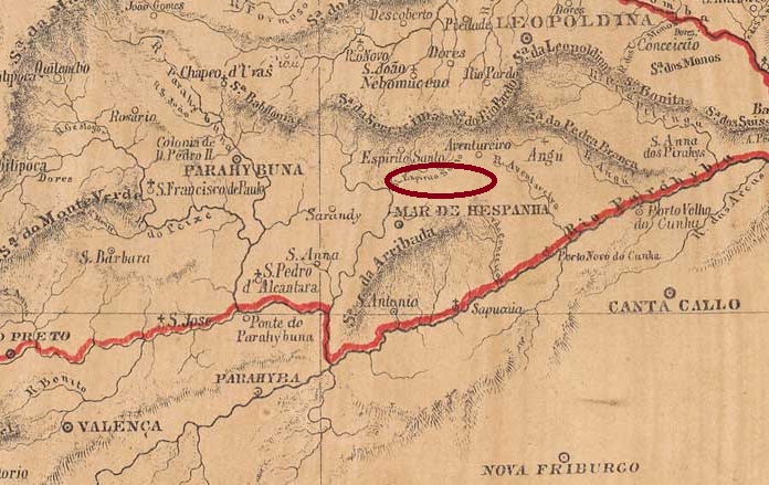
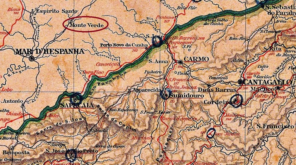
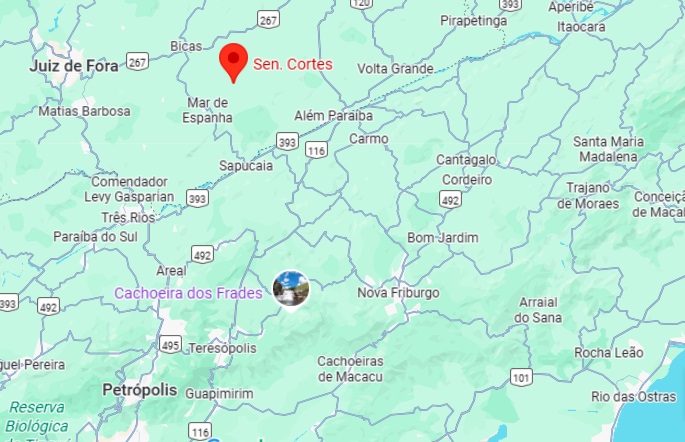
The Freguesia de São Sebastião do Monte Verde existed since October 1881, belonged to the Municipality of Mar de Espanha and was located 2.80 km south of the provincial capital Ouro Preto. In December 1943, it was assigned to the district of Senador Cortes, which has been an independent municipality since December 1962.
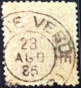
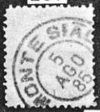
Paula Sobrinho (História Postal de Minas Gerais, Belo Horizonte, 1997) and R. Koester (Carimbologia XXVII) agree that there has also been a post office there since October 1881. The imperial postmark for this is MMG-1640a (image from the internet):
MMG-1640a (EB) 1885Almanak Laemmert, 1892
Outros nomes: Senador Cortes (1943)
A Freguesia de São Sebastião do Monte Verde existia desde outubro de 1881, pertencia ao Município de Mar de Espanha e ficava a 2,80 km ao sul da capital provincial, Ouro Preto. Em dezembro de 1943, foi incorporada ao distrito de Senador Cortes, que desde dezembro de 1962 é um município independente.
Paula Sobrinho (História Postal de Minas Gerais, Belo Horizonte, 1997) e R. Koester (Carimbologia XXVII) concordam que havia uma agência dos correios no local desde outubro de 1881. O carimbo postal imperial é MMG-1640a (figura da Internet):
MMG-1640a (EB) 1885Google Maps
Andere Namen: Senador Cortes (1943)
Die Freguesia de São Sebastião do Monte Verde bestand seit Oktober 1881, gehörte zum Municipio de Mar de Espanha und lag 2.80 km südlich der Provinzhauptstadt Ouro Preto. Im Dezember 1943 wurde sie dem Distrikt Senador Cortes zugeordnet, der seit Dezember 1962 ein eigenständiger Munizip ist.
Paula Sobrinho (História Postal de Minas Gerais, Belo Horizonte, 1997) und R. Koester (Carimbologia XXVII) sind sich einig, dass es dort auch seit Oktober 1881 ein Postamt gab. Der kaiserliche Poststempel davon ist MMG-1640a (Abb. aus dem Internet):
The official history of this town began in March 1849 with the construction of the Nossa Senhora da Conceição da Medalha Milagrosa de Jaboticabal chapel on the provincial border with São Paulo, 530 kilometres southwest of the capital Ouro Preto. According to local legend, the neighbouring Morro Pelado (Bald Mountain) was also called Monte Silhão because it was shaped like a saddle. But the missionaries turned it into Sião (Sion) …
Mount Sião, July 1925 (Photo: Alexandre Marangoni, on Google Maps)
Be that as it may, Monte Sião became a district of Vila de Ouro Fino in April 1854, a Freguesia de Nossa Senhora da Conceição de Monte Sião in December 1874 and an independent municipality in November 1936.
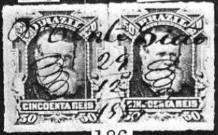
As can be seen from the postal report (Relatorio dos Correios) for the year 1886, there had been a post office there since July 1881. The stamps were initially cancelled by hand, as shown in the picture from R. Koester’s Carimbologia XXVII:
1883 (RK)
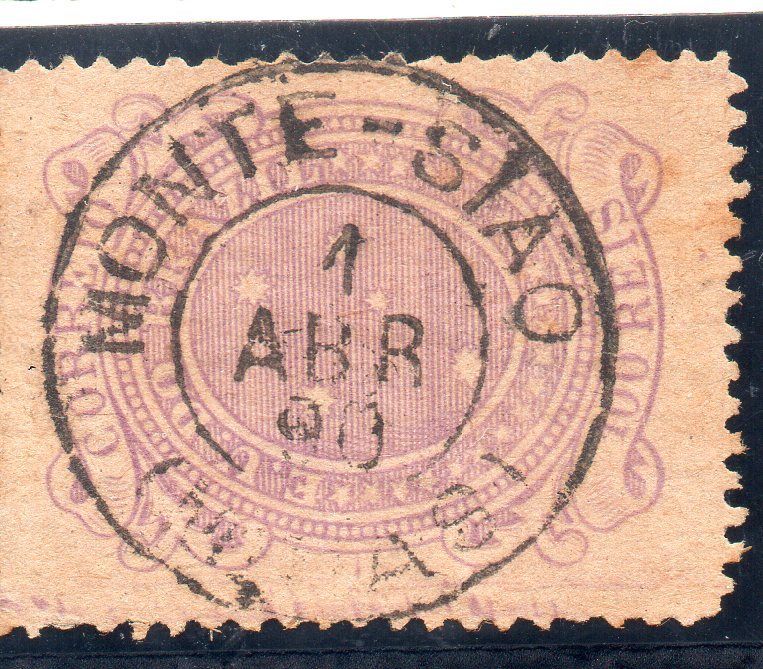
The oldest postmark is MMG-1635a, also illustrated in Koester (op. cit.):
MMG-1635a (RK) 1885
Towards the end of the century, MMG-1635b also appeared (illustration from the internet):
MMG-1635b (EB) 1890Estrada de Ferro Central do Brasil, 1890
Outros nomes: Morro Pelado, Jaboticabal
A história oficial desta localidade começou em março de 1849 com a construção da capela Nossa Senhora da Conceição da Medalha Milagrosa de Jaboticabal, na fronteira com o estado de São Paulo, 530 quilômetros a sudoeste da capital Ouro Preto. Segundo uma lenda local, o vizinho Morro Pelado também era chamado de Monte Silhão, por ter a forma de uma sela. Mas os missionários teriam transformado esse nome em Sião …
Seja como for, Monte Sião tornou-se um distrito da Vila de Ouro Fino em abril de 1854, uma Freguesia de Nossa Senhora da Conceição de Monte Sião em dezembro de 1874 e um município independente em novembro de 1936.
Conforme consta no Relatório dos Correios de 1886, havia uma agência postal no local desde julho de 1881. Inicialmente, os selos eram carimbados à mão, como mostra a imagem de R. Koester em Carimbologia XXVII:
1883 (RK)
O carimbo postal mais antigo é o MMG-1635a, também ilustrado em Koester (op. cit.):
MMG-1635a (RK) 1885
No final do século, surgiu também o MMG-1635b (imagem da Internet):
MMG-1635b (EB) 1890Google Maps
Andere Namen: Morro Pelado, Jaboticabal
Die offizielle Geschichte dieser Ortschaft begann im März 1849 mit dem Bau der Kapelle Nossa Senhora da Conceição da Medalha Milagrosa de Jaboticabal an der Provinzgrenze zu São Paulo, 530 Kilometer südwestlich der Hauptstadt Ouro Preto. Einer lokalen Legende zufolge hieß der benachbarte Morro Pelado (Kahlberg) auch Monte Silhão, da er die Form eines Sattels habe. Doch die Missionare hätten daraus Sião (Sion) gemacht …
Der Berg Sião, Juli 1925 (Foto: Alexandre Marangoni, auf Google Maps)
Wie dem auch sei, Monte Sião wurde im April 1854 ein Distrikt der Vila de Ouro Fino, im Dezember 1874 eine Freguesia de Nossa Senhora da Conceição de Monte Sião und im November 1936 eine eigenständige Gemeinde.
Wie aus dem Postbericht (Relatorio dos Correios) für das Jahr 1886 hervorgeht, gab es dort seit Juli 1881 ein Postamt. Die Briefmarken wurden zunächst per Hand entwertet, wie das Bild aus R. Koesters Carimbologia XXVII zeigt:
1883 (RK)
Der älteste Poststempel ist MMG-1635a, auch im Koester (op. cit.) abgebildet):
MMG-1635a (RK) 1885
Gegen Ende des Jahrhunderts erschien auch MMG-1635b (Abb. aus dem Internet):
Other names: S. Francisco do Tejuco, Monte Santo de Minas (1948)
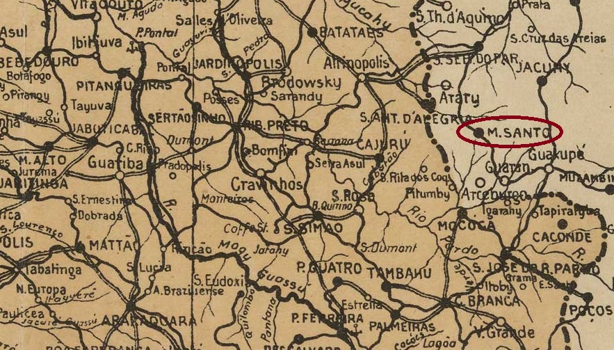
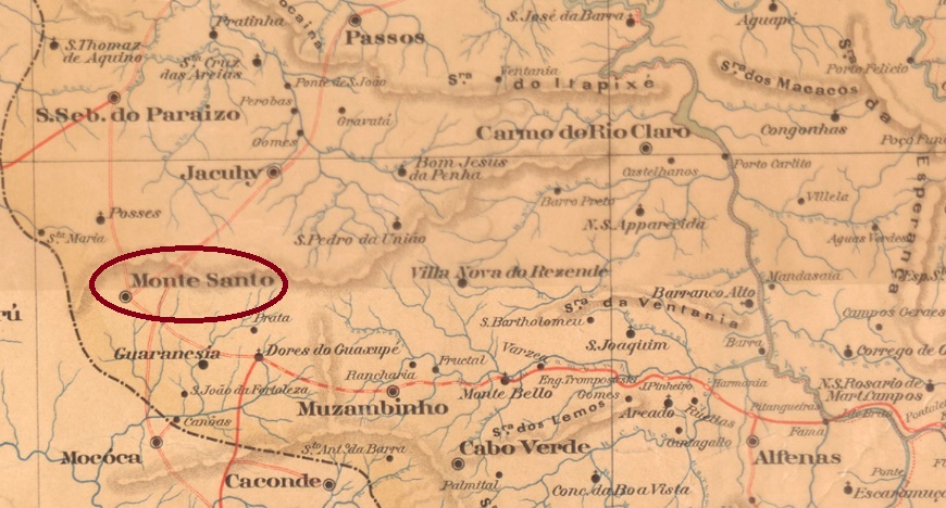
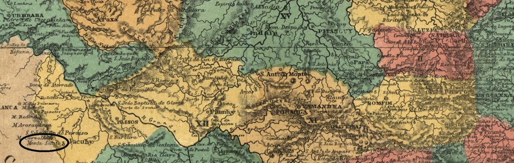
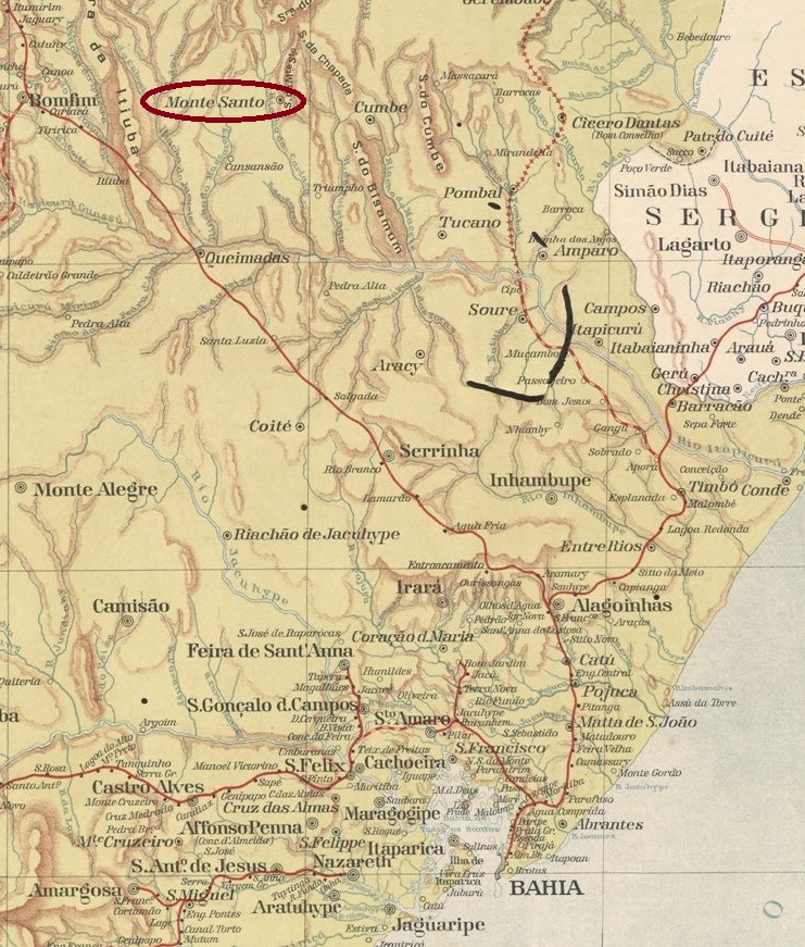
Arraial de São Francisco de Paula do Tejuco was first mentioned in documents in 1820. It was located 520 kilometres west of what would later become the provincial capital, Ouro Preto. In June 1858, the town was renamed Freguesia de São Francisco das Chagas do Monte Santo and belonged to Vila de Jacuhy. Monte Santo was designated a vila in November 1890 and a town in May 1892. As there was also a place with this name in Bahia, it was declared the município de Montesanto by decree in December 1943 and renamed Monte Santo de Minas five years later.
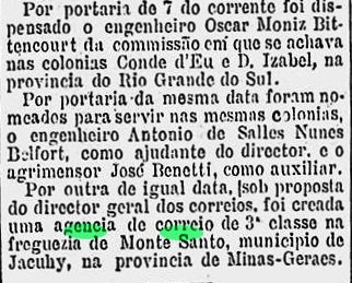
As reported by the Rio press, there had been a post office there since November 1881:
Gazeta de Noticias/RJ, 09.11.1881
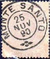
The only imperial postmark to date is MMG-1630a (image from the internet):
MMG-1630a (EB) 1885-1893Estado de Minas Geraes, 1910
Outros nomes: S. Francisco do Tejuco, Monte Santo de Minas (1948)
Desde 1820, o Arraial de São Francisco de Paula do Tejuco era mencionado em documentos. Ele ficava a 520 quilômetros a oeste da futura capital provincial, Ouro Preto. Em junho de 1858, o local foi renomeado para Freguesia de São Francisco das Chagas do Monte Santo e passou a pertencer à Vila de Jacuhy. Monte Santo foi nomeada vila em novembro de 1890 e cidade em maio de 1892. Como esse nome também existia na Bahia, em dezembro de 1943 foi declarado município de Montesanto por decreto e, cinco anos depois, renomeado Monte Santo de Minas.
Conforme divulgado pela imprensa do Rio, havia uma agência dos correios no local desde novembro de 1881:
Gazeta de Notícias/RJ, 09.11.1881
O único carimbo postal imperial conhecido até o momento é o MMG-1630a (figura da internet):
MMG-1630a (EB) 1885-1893Atlas do Imperio do Brasil, 1868
Andere Namen: S. Francisco do Tejuco, Monte Santo de Minas (1948)
Seit 1820 war der Arraial de São Francisco de Paula do Tejuco urkundlich erwähnt. Er lag 520 Kilometer westlich der späteren Provinzhauptstadt Ouro Preto. Im Juni 1858 wurde der Ort in Freguesia de São Francisco das Chagas do Monte Santo umbenannt und gehörte zur Vila de Jacuhy. Monte Santo wurde im November 1890 zur Vila und im Mai 1892 zur Stadt ernannt. Da es diesen Ortsnamen auch in Bahia gab, wurde er im Dezember 1943 per Dekret zum Município de Montesanto erklärt und fünf Jahre später in Monte Santo de Minas umbenannt.
Wie die Presse aus Rio bekannt gab, gab es dort seit November 1881 ein Postamt:
Gazeta de Noticias/RJ, 09.11.1881
Der bisher einzige kaiserliche Poststempel ist MMG-1630a (Abb. aus dem Internet):
Villiers de l’Ile Adam: Carta (…) da Provincia da Bahia, 1848
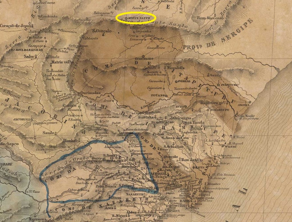
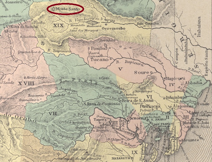
Originally, this village was called Freguesia de Nossa Senhora da Conceição e Santíssimo Coração de Jesus de Monte Santo and belonged to Vila de Itapicuru. It was located 360 km north of the colonial capital Salvador da Bahia. In March 1837, it became a vila and in July 1929 a city.
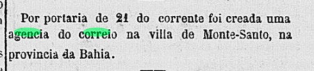
As reported by the Rio press, there had been a post office there since October 1865:
Correio Mercantil/RJ, 25 October 1865
The oldest postmark to date, MBA-0495b (image from the internet), is not the first, as it already bears a date from the 20th century:
MBA-0495b (EB) 1902Estado da Bahia, 1913
Originalmente, essa localidade era a Freguesia de Nossa Senhora da Conceição e Santíssimo Coração de Jesus de Monte Santo e pertencia à Vila de Itapicuru. Ela ficava a 360 km ao norte da capital colonial Salvador da Bahia. Em março de 1837, tornou-se vila e, em julho de 1929, cidade.
Conforme divulgado pela imprensa do Rio, havia uma agência dos correios no local desde outubro de 1865:
Correio Mercantil/RJ, 25.10.1865
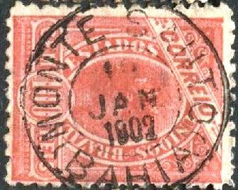
O carimbo postal mais antigo até agora, MBA-0495b (figura da Internet), não é o primeiro, pois já traz uma data do século XX:
MBA-0495b (EB) 1902
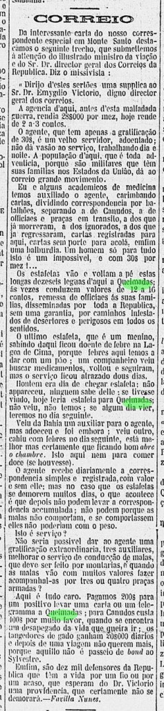
Mas a vila de Monte Santo tem uma importância histórica, pois lá se desenrolou a tragédia de Canudos, o segundo massacre promovido pelo exército republicano (o primeiro foi em Anhatomirim, durante a Revolução Federalista de 1893, em Santa Catarina). Existe um depoimento tão curioso como importante sobre os serviços postais em Monte Santo logo após Canudos, publicado pela imprensa carioca:
Gazeta de Notícias/RJ, 24.09.1897Atlas do Imperio do Brasil, 1868
Ursprünglich war diese Ortschaft die Freguesia de Nossa Senhora da Conceição e Santíssimo Coração de Jesus de Monte Santo und gehörte zur Vila de Itapicuru. Sie lag 360 km nördlich der Kolonialhauptstadt Salvador da Bahia. Im März 1837 wurde sie zur Vila und im Juli 1929 zur Stadt.
Wie die Presse aus Rio bekannt gab, gab es dort seit Oktober 1865 ein Postamt:
Correio Mercantil/RJ, 25.10.1865
Das bisher älteste Poststempel MBA-0495b (Abb. aus dem Internet) ist nicht der erste, denn er trägt bereits ein Datum aus dem 20. Jahrhundert:
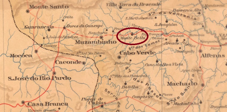
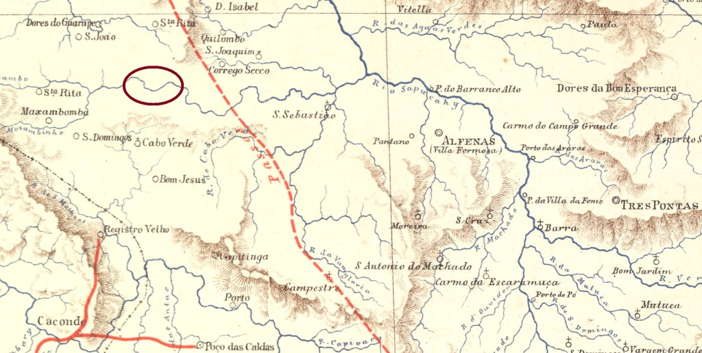
The former settlement of Capela dos Lopes was located on the southern bank of the Muzambinho River, 450 kilometres southwest of the provincial capital Ouro Preto. In November 1880, it became a district of Vila de Cabo Verde and in November 1882, it became Freguesia de Nossa Senhora Imaculada Conceição de Monte Bello. Since December 1938, Monte Belo (the current spelling) has been a município.
R. Koester writes in Carimbologia XXVII that there had been a post office there since August 1888.
The imperial postmark is MMG-1620a (Fig. Koester, op. cit.):
MMG-1620a (RK) 1890Estrada de Ferro Central do Brasil, 1890
Outros nomes: Capela dos Lopes
A antiga povoação de Capela dos Lopes ficava na margem sul do rio Muzambinho, 450 quilômetros a sudoeste da capital provincial, Ouro Preto. Em novembro de 1880, tornou-se um distrito da Vila de Cabo Verde e, em novembro de 1882, a Freguesia de Nossa Senhora Imaculada Conceição de Monte Bello. Desde dezembro de 1938, Monte Belo (segundo a grafia atual) é um município.
R. Koester escreve em Carimbologia XXVII que havia uma agência dos correios no local desde agosto de 1888.
O carimbo postal imperial é MMG-1620a (fig. Koester, op. cit.):
MMG-1620a (RK) 1890Google Maps
Andere Namen: Capella dos Lopes
Die ehemalige Siedlung Capela dos Lopes lag am Südufer des Muzambinho, 450 Kilometer südwestlich der Provinzhauptstadt Ouro Preto. Im November 1880 wurde sie zu einem Distrikt der Vila de Cabo Verde und im November 1882 zur Freguesia de Nossa Senhora Imaculada Conceição de Monte Bello. Seit Dezember 1938 ist Monte Belo (so die heutige Schreibweise) ein Município.
R. Koester schreibt in Carimbologia XXVII, dass es dort seit August 1888 ein Postamt gab.
Der kaiserliche Poststempel ist MMG-1620a (Abb. Koester, op. cit.):
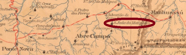
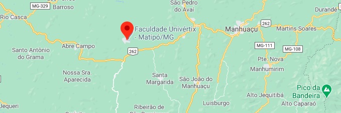
São João do Matipoó was, from September 1887, a district in the municipality of Abre Campo, 170 km east of the provincial capital Ouro Preto. It achieved his political emancipation in December 1938 as the Municipality of Matipó.
As Paula Sobrinho writes in his Historia Postal de Minas Gerais (Belo Horizonte, 1997), there had been a post office there since July 1882. The oldest cancel found here is MMG-2380a (image: Felipe Piccinini):
MMG-2380a (FP) 1889
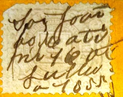
There is also a letter from S. João do Matipoó to Cattas Altas in the province of Minas Gerais, showing a handwritten cancellation, dated 16.7.1888 (although the numbers rather suggest 1855):
Coll. Fuad Ferreira Fo.
For cancels with S. João do Matipoó see SMG-2380.
Google Maps
Andere Schreibweise: Matipó
Siehe auch S. João do Matipoó (SMG-2380)
São João do Matipoó war ab September 1887 ein Distrikt im Município von Abre Campo, der gut 170 km östlich der Provinzhauptstadt Ouro Preto entfernt lag. Er erlangte seine politische Emanzipation im Dezember 1938 als Município von Matipó.
Wie Paula Sobrinho in seiner Historia Postal de Minas Gerais (Belo Horizonte, 1997) schreibt, gab es dort ein Postamt seit Juli 1882. Der älteste dort gefundene Stempel ist MMG-2380a (Bild: Felipe Piccinini):
MMG-2380a (FP) 1889
Es ist auch ein Brief vom S. João do Matipoó nach Cattas Altas in der Provinz Minas Gerais aufgetaucht, der eine handschriftliche Entwertung enthält, datiert 16.7.1888 (wobei die Zahlen eher 1855 vermuten lassen):
Samml. Fuad Ferreira Fo.
Für Stempel mit S. João do Matipoó siehe SMG-2380.
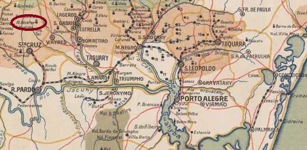
Since 1859, Monte Alverne had been a colony of Vila de Rio Pardo, located 150 kilometres west of the provincial capital Porto Alegre. In March 1877, this colony was transferred to the then newly founded Vila de Santa Cruz (today: Santa Cruz do Sul) and became a district of this municipality in December 1907.
As reported by the Rio press, there had been a post office there since October 1882:
Gazeta da Tarde/RJ, 19 October 1882
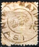
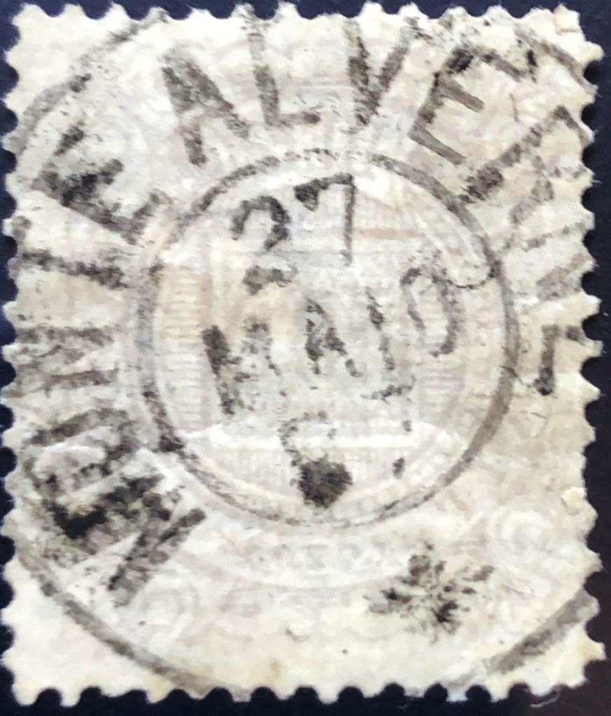
The oldest postmark to date is the double circle MRS-0220a (fig. Robson Peniche):
MRS-0220a (RP) 1887-1891
R. Koester also shows the stamp with the imperial seal MRS-0220b in Carimbologia XXVII:
MRS-0220b (RK)Provincia de São Pedro do Rio Grande, 1877
Desde 1859, Monte Alverne era uma colônia da Vila de Rio Pardo, localizada 150 quilômetros a oeste da capital do estado, Porto Alegre. Em março de 1877, essa colônia passou a fazer parte da então recém-fundada Vila de Santa Cruz (hoje: Santa Cruz do Sul) e, em dezembro de 1907, tornou-se um distrito desse município.
Conforme divulgado pela imprensa do Rio, havia uma agência dos correios no local desde outubro de 1882:
Gazeta da Tarde/RJ, 19/10/1882
O carimbo postal mais antigo até agora é o círculo duplo MRS-0220a (fig. Robson Peniche):
MRS-0220a (RP) 1887-1891
R. Koester também mostra na Carimbologia XXVII o carimbo com o sinete imperial MRS-0220b:
MRS-0220b (RK)Estado do Rio Grande do Sul, 1924
Seit 1859 war Monte Alverne eine Kolonie der Vila de Rio Pardo, die 150 Kilometer westlich der Provinzhauptstadt Porto Alegre lag. Im März 1877 ging diese Kolonie zur damals neu gegründeten Vila de Santa Cruz (heute: Santa Cruz do Sul) über und wurde im Dezember 1907 zu einem Distrikt dieses Municípios.
Wie die Presse aus Rio bekannt gab, gab es dort seit Oktober 1882 ein Postamt:
Gazeta da Tarde/RJ, 19.10.1882
Der bisher älteste Poststempel ist der Doppelkreis MRS-0220a (Abb. Robson Peniche):
MRS-0220a (RP) 1887-1891
R. Koester zeigt auch im Carimbologia XXVII den Stempel mit dem kaiserlichen Siegel MRS-0220b:
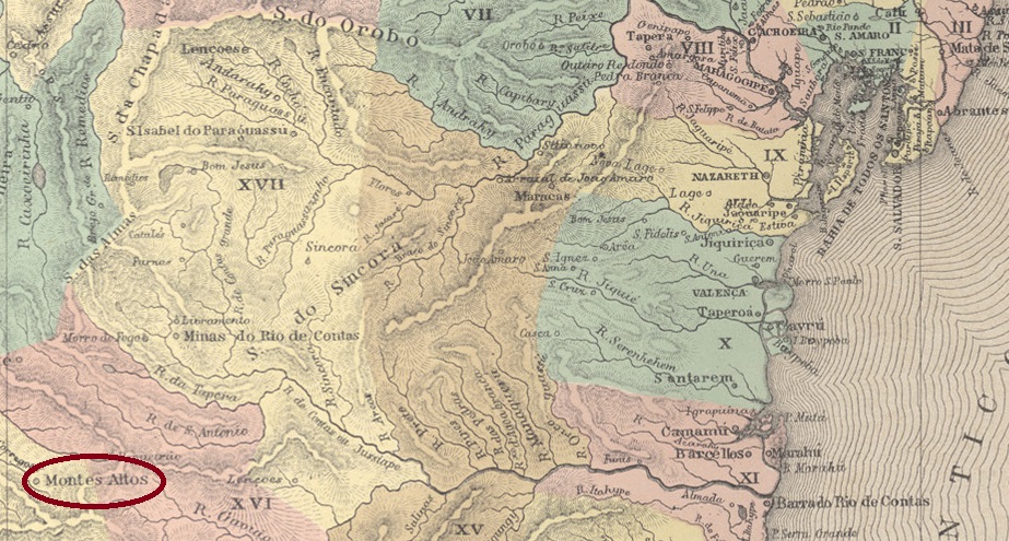
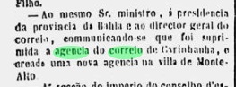
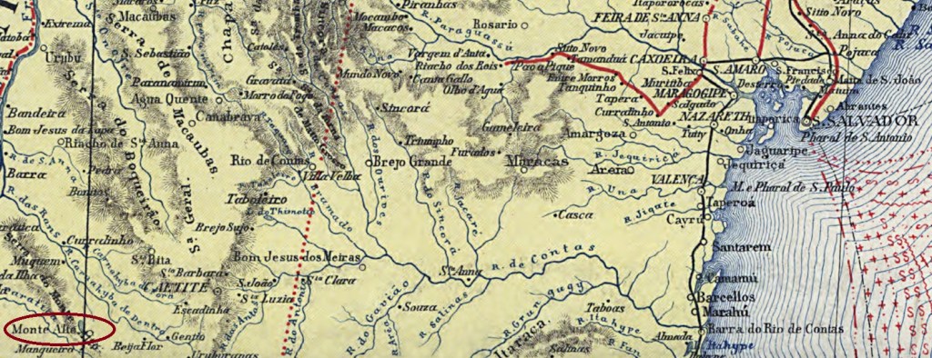
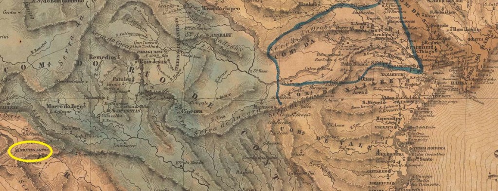
Other names: Montes Altos, Palmas de Monte Alto (1943)
The settlement of Praia das Palmas de Monte Alto was located 680 km west of the colonial capital Salvador da Bahia and had existed since 1742. In May 1840, it became the Freguesia de Nossa Senhora da Mãe de Deus e dos Homens de Monte Alto and, at the same time, the Vila de Monte Alto. In July 1918, it was granted city status. In July 1931, Monte Alto was downgraded to a district of the Município de Guanambi, but regained its independence in May 1933. Since December 1943, the municipality has been called Palmas de Monte Alto.
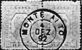
R. Koester writes in Carimbologia XXVII that there had been a post office there since March 1864. However, this was a reopening, as the Monte Alto post office had already been created in May 1852, as announced by the press in Rio de Janeiro.
Diario do Rio de Janeiro, 26 May 1852
It was closed by the end of 1856, as the agency is not listed in the ‘Guia do Correio do Brasil’ (Rio de Janeiro, 1857). The only imperial postmark to date is MBA-0490b (Fig. Koester, op. cit.):
MBA-0490b (RK) 1883-1892Carta da Republica dos Estados Unidos do Brazil, 1892
Outros nomes: Montes Altos, Palmas de Monte Alto (1943)
O povoado Praia das Palmas de Monte Alto ficava a 680 km a oeste da capital colonial Salvador da Bahia e existia desde 1742. Em maio de 1840, tornou-se a Freguesia de Nossa Senhora da Mãe de Deus e dos Homens de Monte Alto e, ao mesmo tempo, a Vila de Monte Alto. Em julho de 1918, recebeu o status de cidade. Em julho de 1931, Monte Alto foi rebaixada a distrito do município de Guanambi, mas recuperou sua autonomia em maio de 1933. Desde dezembro de 1943, o município se chama Palmas de Monte Alto.
R. Koester escreve em Carimbologia XXVII que havia uma agência dos correios no local desde março de 1864. No entanto, trata-se de uma reabertura, pois já em maio de 1852 fora criada a agência postal de Monte Alto, conforme divulgado pela imprensa do Rio de Janeiro.
Diário do Rio de Janeiro, 26/05/1852
Ela foi fechada até o final de 1856, pois a agência não consta mais no “Guia do Correio do Brasil” (Rio de Janeiro, 1857). O único carimbo postal imperial conhecido até o momento é o MBA-0490b (fig. Koester, op. cit.):
MBA-0490b (RK) 1883-1892Villiers de l’Ile Adam: Carta (…) da Provincia da Bahia, 1848
Textaktualisierung am 25. Dezember 2025
Andere Namen: Montes Altos, Palmas de Monte Alto (1943)
Die Siedlung Praia das Palmas de Monte Alto lag 680 km westlich der Kolonialhauptstadt Salvador da Bahia und existierte seit 1742. Im Mai 1840 wurde sie zur Freguesia de Nossa Senhora da Mãe de Deus e dos Homens de Monte Alto und gleichzeitig zur Vila de Monte Alto. Im Juli 1918 erhielt sie den Stadtstatus. Im Juli 1931 wurde Monte Alto zum Distrikt des Município de Guanambi herabgestuft, erhielt jedoch im Mai 1933 die Selbstständigkeit zurück. Seit Dezember 1943 heißt der Munizip Palmas de Monte Alto.
R. Koester schreibt in Carimbologia XXVII, dass es dort seit März 1864 ein Postamt gab. Hierbei handelt es sich jedoch um eine Wiedereröffnung, denn bereits im Mai 1852 wurde beschlossen, eine Postagentur Monte Alto einzurichten, wie die Presse aus Rio de Janeiro bekannt gab.
Diario do Rio de Janeiro, 26.05.1852
Das Postamt wurde vor dem Ende des Jahres 1856 geschlossen, da es im „Guia do Correio do Brasil” (Rio de Janeiro, 1857) nicht aufgeführt wird. Der bisher einzige kaiserliche Poststempel ist MBA-0490b (Abb. Koester, op. cit.):
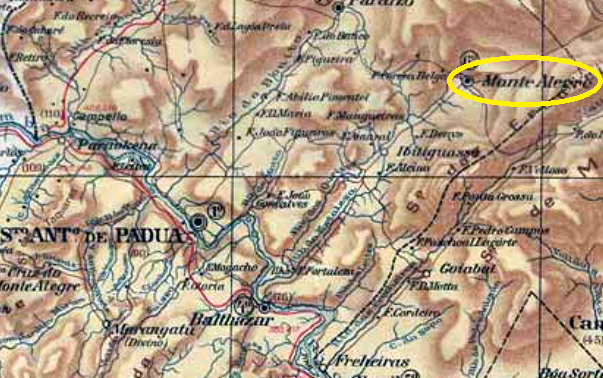
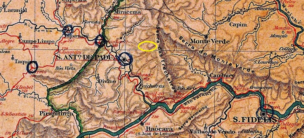
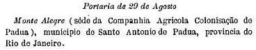
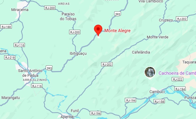
The Monte Alegre farm was located in the Vila de Santo Antonio de Padua area, 270 kilometres northeast of the capital Rio de Janeiro. In December 1886, it was converted into an agricultural colony by imperial decree – an unorthodox measure, to say the least, which ultimately failed. However, the settlement continued to grow and in November 1915 became a district, which was renamed Ibitiporã in December 1943. In January 1967, the old place name Monte Alegre was finally restored.
According to the 1889 Post Bulletin (Boletim Postal), there had been a post office there since August 1889.
Boletim Postal No. 5, September 1889
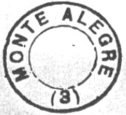
Paulo Novaes states on agenciaspostais.com.br that the agency was moved to Ibitiguassu in May 1892. According to R. Koester (Carimbologia XXVII), the postmark MRJ-2425a belongs to Monte Alegre in the province of Rio de Janeiro:
MRJ-2425a (RK)Almanak Laemmert, 1892
Outros nomes: Ibitiporã
A Fazenda Monte Alegre ficava na área da Vila de Santo Antônio de Pádua, 270 quilômetros a nordeste da capital Rio de Janeiro. Em dezembro de 1886, ela foi transformada em colônia agrícola por decreto imperial – uma medida pouco ortodoxa, que acabou fracassando. No entanto, o povoado continuou a crescer e, em novembro de 1915, tornou-se um distrito, que em dezembro de 1943 foi renomeado para Ibitiporã. Em janeiro de 1967, finalmente voltou a ser chamado pelo antigo nome de Monte Alegre.
Conforme consta no Boletim Postal de 1889, a agência dos correios local foi driada em agosto de 1889.
Boletim Postal nº 5, setembro de 1889
Paulo Novaes escreve em agenciaspostais.com.br que a agência foi transferida para Ibitiguassu em maio de 1892. Segundo R. Koester (Carimbologia XXVII), o carimbo postal MRJ-2425a pertence a Monte Alegre, na província do Rio de Janeiro:
MRJ-2425a (RK)Google Maps
Andere Namen: Ibitiporã
Die Fazenda Monte Alegre lag im Gebiet der Vila de Santo Antonio de Padua, 270 Kilometer nordöstlich der Hauptstadt Rio de Janeiro. Im Dezember 1886 wurde sie per kaiserlichem Dekret in eine Landwirtschaftskolonie umgewandelt – eine zumindest unorthodoxe Maßnahme, die jedoch scheiterte. Die Siedlung wuchs jedoch weiter und wurde im November 1915 zu einem Distrito, der im Dezember 1943 in Ibitiporã umbenannt wurde. Im Januar 1967 kehrte schließlich der alte Ortsname Monte Alegre zurück.
Wie dem Postbulletin (Boletim Postal) von 1889 zu entnehmen ist, gab es dort seit August 1889 ein Postamt.
Boletim Postal Nr. 5, September 1889
Laut Paulo Novaes auf agenciaspostais.com.br wurde die Agentur im Mai 1892 nach Ibitiguassu verlegt. Laut R. Koester (Carimbologia XXVII) gehört der Poststempel MRJ-2425a zu Monte Alegre in der Provinz Rio de Janeiro:
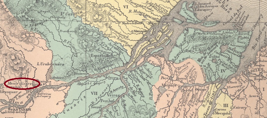
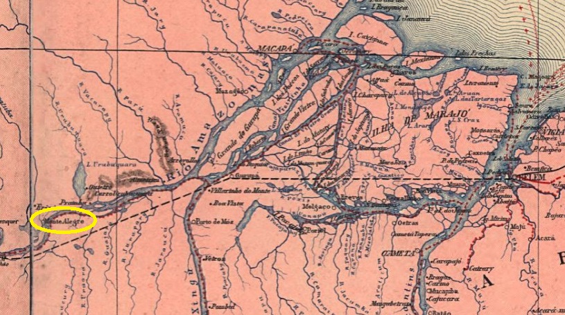
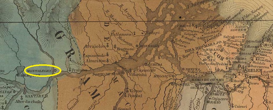
The Indian settlement of Gurupatuba was founded around 1710 on the west bank of the Amazon River, near Lake Monte Alegre, 1,340 kilometres west of what would later become the provincial capital of Belém do Pará. In February 1758, it was declared the Vila de S. Francisco de Assis de Monte Alegre and in March 1880, it was declared a city.
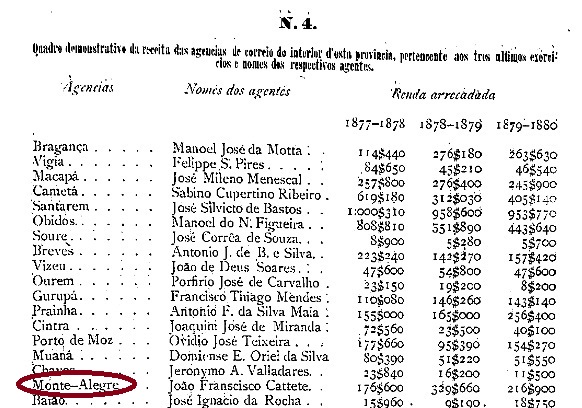
According to Nova Monteiro, there had been a post office there since March 1829, as described in Administrações e Agencias Postaes do Brasil Imperio (Brasil Filatelico/RJ, 1934–1935; reprinted SPP 1994–1999). This was closed around 1852, as can be seen from the report of the Imperial Ministry the following year.
Relatório do Ministério do Império, 1853
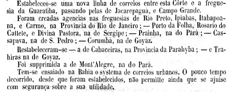
We do not know when the agency reopened, but according to the provincial president’s report from February 1881, it was already in operation in 1877:
Relatório do Presidente da Provincia, February 1881
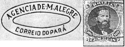
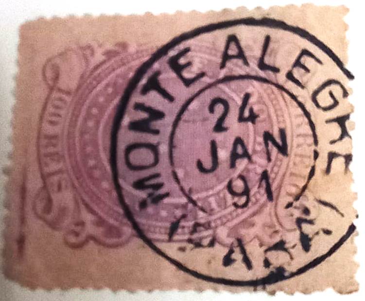
The oldest postmark to date is MPA-0175b (Fig. R. Koester, in Carimbologia XXVII):
MPA-0175b (RK) 1876ff
Later came MPA-0175c (Fuad Ferreira Fo. collection), which also occurs in red and dark purple:
MPA-0175c (FF) 1890-1891Carta da Republica dos Estados Unidos do Brazil, 1892
Outros nomes: Gurupatuba
A aldeia indígena Gurupatuba foi fundada por volta de 1710 na margem oeste do rio Amazonas, perto do lago Monte Alegre, 1.340 quilômetros a oeste da futura capital do estado, Belém do Pará. Em fevereiro de 1758, foi declarada Vila de S. Francisco de Assis de Monte Alegre e, em março de 1880, cidade.
Segundo Nova Monteiro, havia uma agência dos correios no local desde março de 1829, conforme descrito em Administrações e Agências Postais do Brasil Império (Brasil Filatélico/RJ, 1934–1935; reimpressão SPP 1994–1999). Esta foi fechada por volta de 1852, conforme consta do relatório do Ministério Imperial do ano seguinte.
Relatório do Ministério do Império, 1853
Não sabemos quando a agência foi reaberta, mas, de acordo com o relatório do presidente da província de fevereiro de 1881, ela já estava em funcionamento em 1877:
Relatório do Presidente da Província, fevereiro de 1881
O carimbo postal mais antigo até agora é o MPA-0175b (fig. R. Koester, em Carimbologia XXVII):
MPA-0175b (RK) 1876ff
Mais tarde surgiu o MPA-0175c (Coleção Fuad Ferreira Fo.), que também existe em vermelho e violeta escuro:
MPA-0175c (FF) 1890-1891Villiers de l’Ile Adam: Carta (…) da Republica dos Estados Unidos do Brasil, 1850
Andere Namen: Gurupatuba
Die Indianersiedlung Gurupatuba entstand um 1710 am Westufer des Amazonas, in der Nähe des Monte-Alegre-Sees, 1.340 Kilometer westlich der späteren Provinzhauptstadt Belém do Pará. Im Februar 1758 wurde sie zur Vila de S. Francisco de Assis de Monte Alegre und im März 1880 zur Stadt erklärt.
Laut Nova Monteiro gab es dort seit März 1829 ein Postamt, wie in Administrações e Agencias Postaes do Brasil Imperio (Brasil Filatelico/RJ, 1934–1935; Nachdruck SPP 1994–1999) beschrieben. Dieses wurde um 1852 geschlossen, wie aus dem Bericht des kaiserlichen Ministeriums des Folgejahres hervorgeht.
Relatório do Ministério do Império, 1853
Wir wissen nicht, wann die Agentur wiedereröffnet wurde, doch war sie laut dem Bericht des Provinzpräsidenten aus dem Februar 1881 bereits 1877 in Betrieb:
Relatorio do Presidente da Provincia, Februar 1881
Der bisher älteste Poststempel ist MPA-0175b (Abb. R. Koester, in Carimbologia XXVII):
MPA-0175b (RK) 1876ff
Später kam MPA-0175c (Samml. Fuad Ferreira Fo.), den es auch in rot und dunkelviolett gibt: