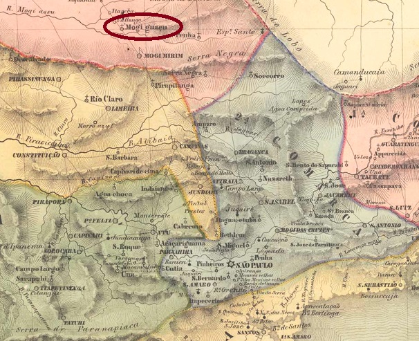
Villiers de l’Ile Adam: Carta (…) da Provincia de São Paulo, 1947
Other spellings: Moji-Guaçu, Mogi Guaçu
The Freguesia de Nossa Senhora da Conceição de Mogi Guaçu existed since 1740, belonged to the Vila de Jundiaí and was located on the north bank of the Mogi Guaçu (as the river is spelled today). It was located 160 kilometres north of the later provincial capital São Paulo. In 1769, the Freguesia moved to the Vila de Mogi Mirim and became a Vila itself in April 1877. It has been a city since December 1906, adopting the spelling ‘Moji-Guaçu’ in November 1944 and ‘Mogi Guaçu’ since March 1991.
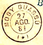
As can be seen from the directory of imperial post offices (Tabella das Agencias do Correio do Imperio, Rio de Janeiro, 1885), there has been a post office there since 1876. The imperial postmark is the French type MSP-0815a (Fig. Rodrigo Baldassare):
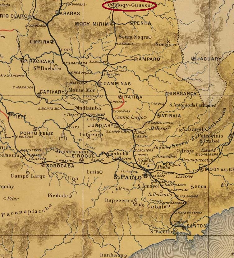
MSP-0815a (RB) 1880-1897J. M. Ribeiro Lisboa: Provincia de São Paulo, 1884
Outras grafias: Moji-Guaçu, Mogi Guaçu
A Freguesia de Nossa Senhora da Conceição de Mogi Guaçu existia desde 1740, pertencia à Vila de Jundiaí e ficava na margem norte do Mogi Guaçu (como é escrito hoje). Ela ficava a 160 quilômetros ao norte da futura capital provincial, São Paulo. Em 1769, a Freguesia mudou para a Vila de Mogi Mirim e, em abril de 1877, tornou-se ela própria uma vila. Desde dezembro de 1906, é uma cidade que, em novembro de 1944, adotou a grafia “Moji-Guaçu” e, desde março de 1991, é escrita como “Mogi Guaçu”.
Conforme consta na Tabella das Agências do Correio do Império (Rio de Janeiro, 1885), havia um correio no local desde 1876. O carimbo postal imperial é do tipo francês MSP-0815a (fig. Rodrigo Baldassare):
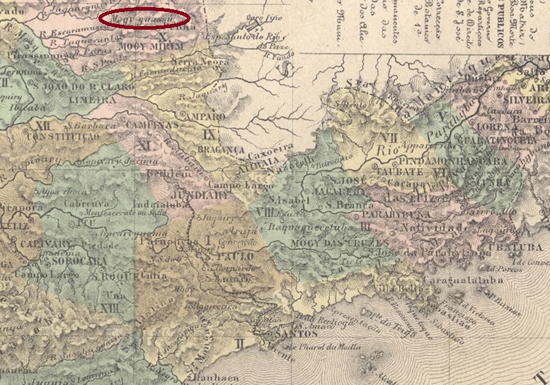
MSP-0815a (RB) 1880-1897Atlas do Imperio do Brasil, 1868
Andere Schreibweisen: Moji-Guaçu, Mogi Guaçu
Die Freguesia de Nossa Senhora da Conceição de Mogi Guaçu bestand seit 1740, gehörte zur Vila de Jundiaí und lag am Nordufer des Mogi Guaçu (wie der Fluss heute geschrieben wird). Sie befand sich 160 Kilometer nördlich der späteren Provinzhauptstadt São Paulo. 1769 wechselte die Freguesia zur Vila de Mogi Mirim und wurde im April 1877 selbst zur Vila. Seit Dezember 1906 ist sie eine Stadt, die im November 1944 die Schreibweise „Moji-Guaçu” annahm und seit März 1991 „Mogi Guaçu” geschrieben wird.
Wie aus dem Verzeichnis der kaiserlichen Postämter (Tabella das Agencias do Correio do Imperio, Rio de Janeiro, 1885) hervorgeht, gab es dort seit 1876 ein Postamt. Der kaiserliche Poststempel ist der französische Typ MSP-0815a (Abb. Rodrigo Baldassare):
Villiers de l’Ile Adam: Carta (…) da Provincia de São Paulo, 1847
Other names: Sant’Anna das Cruzes de Boijy-Mirim
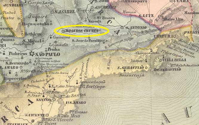
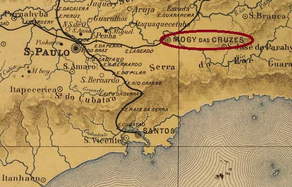
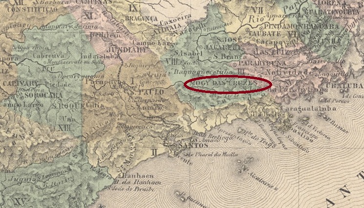
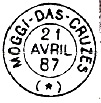
This locality is said to have been a village called Sant’Anna das Cruzes de Boijy-Mirim since November 1611. It was located 60 km east of what would later become the provincial capital of São Paulo. It is not known exactly when the place name was shortened to Mogy das Cruzes, only that Mogi das Cruzes (as it is spelled today) has been a city since March 1855. The name Mogi means ‘river of snakes’ in Tupi-Guaraní.
The dates regarding the local post office are also unclear. Nova Monteiro writes in Administrações e Agencias Postaes do Brasil Imperio (Brasil Filatelico/RJ, 1934–35; reprinted by SPP 1994–99) that a postmaster was appointed in July 1850. The directory of imperial post offices (Tabella das Agencias do Correio do Imperio, Rio de Janeiro, 1885) lists 1845 as the year of establishment.
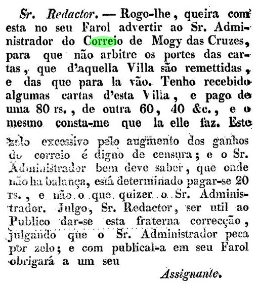
However, a functioning post office in Mogi das Cruzes was already mentioned in the regional press in November 1829:
O Farol Paulistano, 07.11.1829
The agency was probably operated by the provincial administration of São Paulo, as was the case in other towns along the Paraíba do Sul Valley at the time.
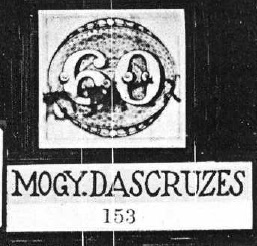
The oldest postmark to date is MSP-0810a (see R. Koester, Carimbologia XXVII):
MSP-0810a (RK – RHM P-SP-021) 1843ff – 1866ff
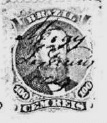
Koester showed a following handwritten cancellation.
1868 (RK)
This was followed by the French type MSP-0810b, which also appears in blue. An illustration of this can be found in P. Ayres’ ‘Catálogo de Carimbos Brasil-Império’ (São Paulo, 1937, 1942):
MSP-0810b (P. A. p. 117) 1877–1888
Towards the end of the Empire, MSP-0810c also appeared (illustration from the Internet):
MSP-0810c (EB) 1889–1909
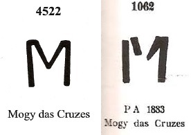
James Dingler and Klerman W. Lopes show in Mute Cancellations of the Brazil Empire / Carimbos Mudos do Brasil Império (Brazil Philatelic Association, Rio de Janeiro, 2000) under No. 4522, they show a postmark with the initial of the place name, which looks slightly different from the template by P. Ayres (No. 1062, op. cit.):
BPA 4522 /P.A. 1062 (1883ff)J.M. Ribeiro Lisboa: Provincia de São Paulo, 1884
Outros nomes: Sant’Anna das Cruzes de Boijy-Mirim
Esta localidade teria sido, desde novembro de 1611, uma vila chamada Sant’Anna das Cruzes de Boijy-Mirim. Ela ficava a 60 km a leste da futura capital provincial, São Paulo. Não se sabe ao certo quando o nome da localidade foi abreviado para Mogy das Cruzes, apenas que Mogi das Cruzes (como é escrito hoje) é uma cidade desde março de 1855. O nome Mogi significa “rio das cobras” em tupi-guarani.
Quanto às datas de criação dos correios locais, também não há clareza. Nova Monteiro escreve em Administrações e Agencias Postaes do Brasil Imperio (Brasil Filatelico/RJ, 1934–35; reimpressão SPP 1994–99) que um agente postal foi nomeado em julho de 1850. Na Tabella das Agencias do Correio do Império (Rio de Janeiro, 1885), o ano de 1845 é indicado como de criação.
No entanto, já em novembro de 1829, uma agência postal em funcionamento em Mogi das Cruzes foi mencionada na imprensa regional:
O Farol Paulistano, 07.11.1829
Presumivelmente, a agência era administrada pela administração provincial de São Paulo, como era o caso na época em outras localidades ao longo do vale do Paraíba do Sul.
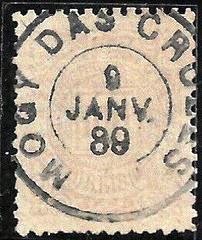
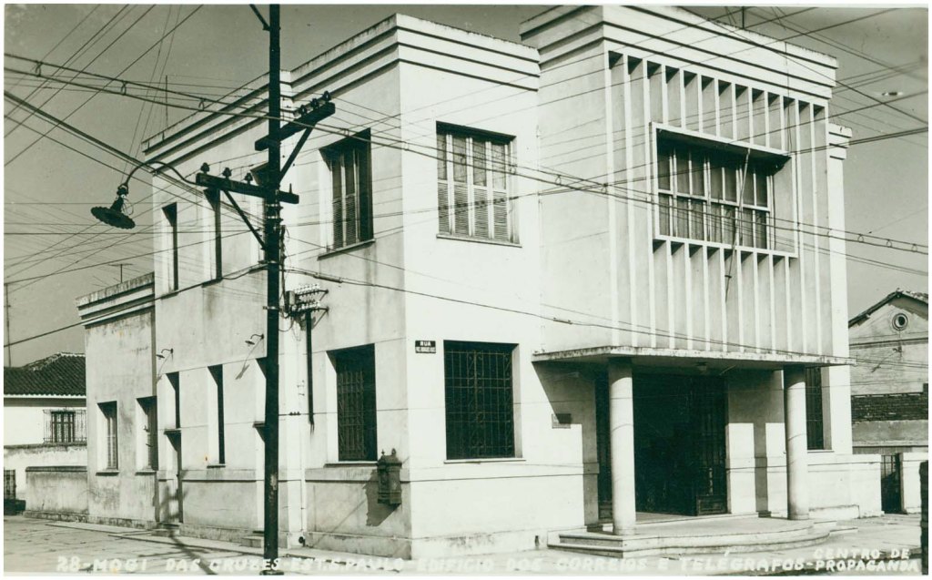
Correio de Mogi das Cruzes, ca. 1960 (IBGE)
O carimbo postal mais antigo até agora é o MSP-0810a (ver R. Koester, Carimbologia XXVII):
MSP-0810a (RK – RHM P-SP-021) 1843 ff – 1866 ff
Koester mostrou em seguida uma obliteração manuscrita.
1868 (RK)
Seguiu-se o tipo francês MSP-0810b, que também existe em azul. Uma ilustração do mesmo pode ser encontrada no “Catálogo de Carimbos Brasil-Império” de P. Ayres (São Paulo, 1937, 1942):
MSP-0810b (P. A. p. 117) 1877–1888
No final do Império, surgiu também o MSP-0810c (imagem da Internet):
MSP-0810c (EB) 1889–1909
James Dingler e Klerman W. Lopes mostram em Mute Cancellations of the Brazil Empire / Carimbos Mudos do Brasil Império (Clube Filatélico do Brasil, Rio de Janeiro, 2000), sob o nº 4522, um carimbo postal com a inicial do nome do local, que parece ligeiramente diferente do modelo de P. Ayres (nº 1062, op. cit.):
BPA 4522 /P.A. 1062 (1883ff)Atlas do Imperio do Brasil, 1868
Andere Namen: Sant’Anna das Cruzes de Boijy-Mirim
Diese Ortschaft soll seit November 1611 eine Vila namens Sant’Anna das Cruzes de Boijy-Mirim gewesen sein. Sie lag 60 km östlich der späteren Provinzhauptstadt São Paulo. Wann genau der Ortsname zu Mogy das Cruzes gekürzt wurde, ist nicht bekannt, nur dass Mogi das Cruzes (wie es heute geschrieben wird) seit März 1855 eine Stadt ist. Der Name Mogi bedeutet „Fluss der Schlangen” in Tupi-Guaraní.
Was das örtliche Postamt betrifft, sind die Daten ebenfalls unklar. Nova Monteiro schreibt in Administrações e Agencias Postaes do Brasil Imperio (Brasil Filatelico/RJ, 1934–35; Nachdruck SPP 1994–99), dass im Juli 1850 ein Postagent ernannt wurde. Im Verzeichnis der kaiserlichen Postämter (Tabella das Agencias do Correio do Imperio, Rio de Janeiro, 1885) wird das Jahr 1845 als Gründungsjahr angegeben.
Allerdings wurde bereits im November 1829 ein funktionierendes Postamt in Mogi das Cruzes in der regionalen Presse erwähnt:
O Farol Paulistano, 07.11.1829
Vermutlich wurde die Agentur von der Provinzverwaltung São Paulos betrieben, wie es damals in anderen Ortschaften entlang des Paraíba-do-Sul-Tals der Fall war.
Der bisher älteste Poststempel ist MSP-0810a (siehe R. Koester, Carimbologia XXVII).
MSP-0810a (RK – RHM P-SP-021) 1843 ff – 1866 ff
Koester zeigte im Anschluss eine handschriftliche Entwertung.
1868 (RK)
Es folgte der französische Typ MSP-0810b, der auch in Blau vorkommt. Eine Abbildung davon findet sich in P. Ayres‘ „Catálogo de Carimbos Brasil-Império” (São Paulo, 1937, 1942):
MSP-0810b (P. A. S. 117) 1877–1888
Gegen Ende des Kaiserreichs erschien auch MSP-0810c (Abbildung aus dem Internet):
MSP-0810c (EB), 1889–1909
James Dingler und Klerman W. Lopes zeigen in Mute Cancellations of the Brazil Empire / Carimbos Mudos do Brasil Império (Brazil Philatelic Association, Rio de Janeiro, 2000) unter Nr. 4522 einen Poststempel mit der Initiale des Ortsnamens, der leicht anders als die Vorlage bei P. Ayres (Nr. 1062, op. cit.) aussieht:
J. M. Ribeiro Lisboa: Provincia de São Paulo, 1884
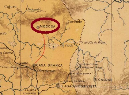
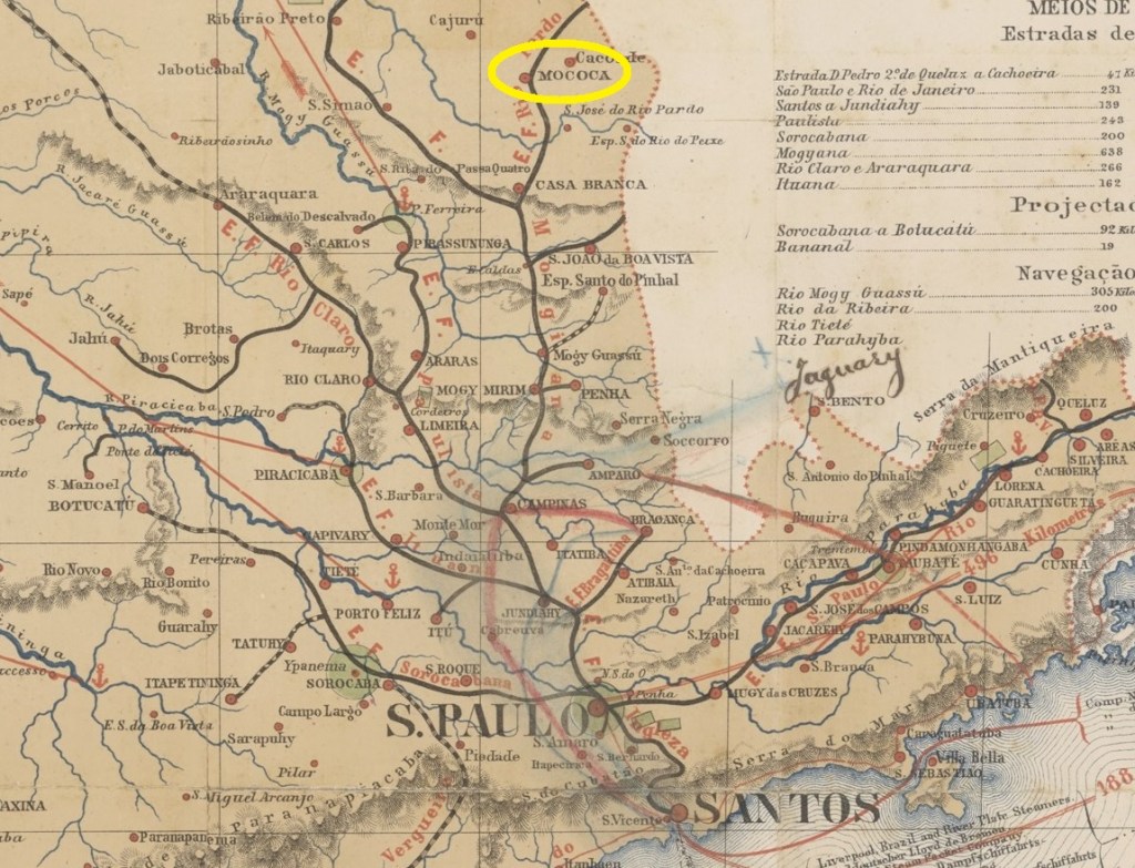
See also São Sebastião da Boa Vista (SSP-1860)
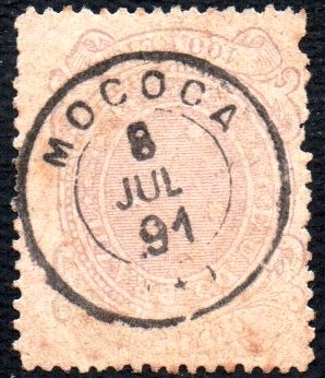
São Sebastião da Boa Vista had been a settlement of Casa Branca since December 1847 and was located close to the border with Minas Gerais, approximately 260 km north of the provincial capital São Paulo. In April 1856, the locality was designated a freguesia and belonged as a district to the vila of Caconde for three years from April 1868 before returning to Casa Branca. Shortly afterwards, it became a vila and has been the city of Mococa since April 1875.
As can be seen in the directory of imperial post offices (Tabella das Agencias do Correio do Imperio, Rio de Janeiro, 1885), there has been a post office there since 1870.
The first postmarks (until around 1886) bear the inscription ‘São Sebastião da Boa Vista’. These were followed by the French-style Mococa postmark MSP-0805a (illustration by Felipe Piccinini):
MSP-0805a (FP) 1885-1892Provincia de São Paulo, 1886
Siehe auch São Sebastião da Boa Vista (SSP-1860)
São Sebastião da Boa Vista war seit Dezember 1847 eine Siedlung von Casa Branca und lag nah an der Grenze zu Minas Gerais, ca. 260 km nördlich der Provinzhauptstadt São Paulo. Im April 1856 wurde der Ort zur Freguesia ernannt und gehörte ab April 1868 für drei Jahre als Distrikt zu Caconde, bevor er wieder zu Casa Branca zurückkehrte. Kurz darauf wurde er zur Vila und ist seit April 1875 die Stadt Mococa.
Wie im Verzeichnis der kaiserlichen Postämter (Tabella das Agencias do Correio do Imperio, Rio de Janeiro, 1885) zu lesen ist, gab es dort seit 1870 ein Postamt.
Die ersten Poststempel (bis ca. 1886) tragen die Inschrift „São Sebastião da Boa Vista”. Danach kam der Mococa-Stempel im französischen Stil MSP-0805a (Abb. von Felipe Piccinini):
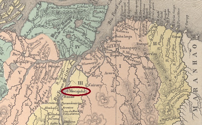
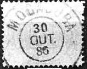
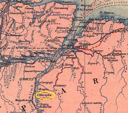
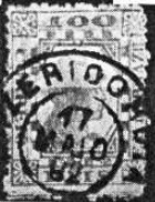
Since around 1800, there had been a settlement called Maxi (or Moxi) on the east bank of the Tocantins River. It was located 240 km southwest of the later provincial capital Belém do Pará. In December 1853, it became the Freguesia de Nossa Senhora da Conceição de Mocajuba and was under the jurisdiction of the Vila de Cametá. In April 1872, Mocajuba was designated a vila and in July 1895 a city. After a brief demotion to distrito in the município de Baião (from November 1930 to October 1935), Mocajuba regained its status as a município. The name comes from the Tupi language and is said to be derived from Mucajá (very fertile palm tree).
R. Koester writes in Carimbologia XXVII that the Mocajuba post office dates to 1882. He probably took this information from the directory of imperial post offices (Tabella das Agencias do Correio do Imperio, Rio de Janeiro, 1885). In fact, the agency was promoted to second class in March 1882, as announced by the Rio press:
O Globo/RJ, 24 March 1882
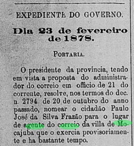
We do not know exactly when this post office was established, only that it happened between April and the end of 1877. This is because in April of that year, the village applied to establish a post office, as reported in the regional press:
Jornal do Pará, 10 May 1877
The same newspaper reported in March 1878 that the agency had been in operation ‘for some time’ (há bastante tempo):
Jornal do Pará, 3 March 1878
The imperial postmark is MPA-0165a (Fig. Koester, op. cit.):
MPA-0165a (RK) 1886Carta da Republica dos Estados Unidos do Brazil, 1892
Andere Namen: Maxi/Moxi
Seit ca. 1800 ist eine Siedlung namens Maxi (oder Moxi) am Ostufer des Tocantins überliefert. Sie lag 240 km südwestlich der späteren Provinzhauptstadt Belém do Pará. Im Dezember 1853 wurde sie zur Freguesia de Nossa Senhora da Conceição de Mocajuba und unterstand der Vila de Cametá. Im April 1872 wurde Mocajuba zur Vila und im Juli 1895 zur Stadt ernannt. Nach einer kurzen Degradierung zum Distrito im Município de Baião (von November 1930 bis Oktober 1935) erhielt Mocajuba den Status eines Municípios wieder. Der Name stammt aus der Tupi-Sprache und soll von Mucajá (sehr fruchtbare Palme) abgeleitet sein.
R. Koester schreibt in Carimbologia XXVII, dass das Postamt Mocajuba aus dem Jahr 1882 stammt. Vermutlich übernahm er diese Angabe aus dem Verzeichnis der kaiserlichen Postämter (Tabella das Agencias do Correio do Imperio, Rio de Janeiro, 1885). Tatsächlich wurde die Agentur im März 1882 in die zweite Klasse befördert, wie die Presse aus Rio bekannt gab.
O Globo/RJ, 24.03.1882
Wir wissen nicht genau, wann dieses Postamt entstand, nur, dass es zwischen April und Ende 1877 geschah. Denn im April desselben Jahres richtete die Vila einen Antrag zur Errichtung einer Postagentur, wie aus der regionalen Presse hervorgeht:
Jornal do Pará, 10.05.1877
Die gleiche Zeitung berichtete im März 1878, dass die Agentur „seit einiger Zeit” (há bastante tempo) in Betrieb stand:
Jornal do Pará, 03.03.1878
Der kaiserliche Poststempel ist MPA-0165a (Abb. Koester, op. cit.):
Villiers de l’Ile Adam: Carta (…) das Provincias do Rio Grande do Norte e Parahiba, 1848
Other names: Itaporanga (1938-43, 1947)
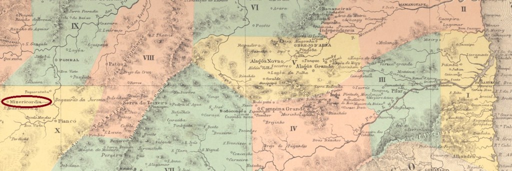
The Freguesia de N. Sr. da Conceição da Misericordia existed since July 1860. It belonged to the Vila de Piancó, was located on the north bank of the Piancó and was 420 km away from the provincial capital Paraíba do Norte (today: João Pessoa). In December 1863, it became a Vila, which has since changed its name three times: in November 1938, it was renamed Itaporanga, in December 1943 it was renamed Misericórdia, and in June 1947 it was renamed Itaporanga again. The name comes from the Tupi-Guaraní language and means ‘beautiful stone’.
As Nova Monteiro writes in Administrações e Agencias Postaes do Brasil Imperio (Brasil Filatelico/RJ, 1934–1935; reprinted by SPP 1994–1999), the establishment of a local post office was decided in September 1867. This is confirmed by the postal report (Relatorio Postal) for 1886. The only postmark known to date is MPB-0155b (illustration Koester, in Carimbologia XXVII):
MPB-0155b (RK) 1891-1893Atlas do Imperio do Brasil, 1868
Andere Namen: Itaporanga (1938-43, 1947)
Die Freguesia de N. Sr. da Conceição da Misericordia bestand seit Juli 1860. Sie gehörte zur Vila de Piancó, lag am Nordufer des Piancó und war 420 km von der Provinzhauptstadt Paraíba do Norte (heute: João Pessoa) entfernt. Im Dezember 1863 wurde sie zur Vila, die seitdem ihren Namen dreimal gewechselt hat: Im November 1938 erhielt sie den Namen Itaporanga, im Dezember 1943 wurde sie wieder in Misericórdia umbenannt und im Juni 1947 erneut in Itaporanga. Der Name stammt aus dem Tupi-Guaraní und bedeutet „Schöner Stein”.
Wie Nova Monteiro in Administrações e Agencias Postaes do Brasil Imperio (Brasil Filatelico/RJ, 1934–1935; Nachdruck SPP 1994–1999) schreibt, wurde im September 1867 die Einrichtung eines Postamts vor Ort beschlossen. Dies wird durch den Postbericht (Relatorio Postal) für 1886 bestätigt. Der bisher einzige Poststempel ist MPB-0155b (Abb. Koester, in Carimbologia XXVII):
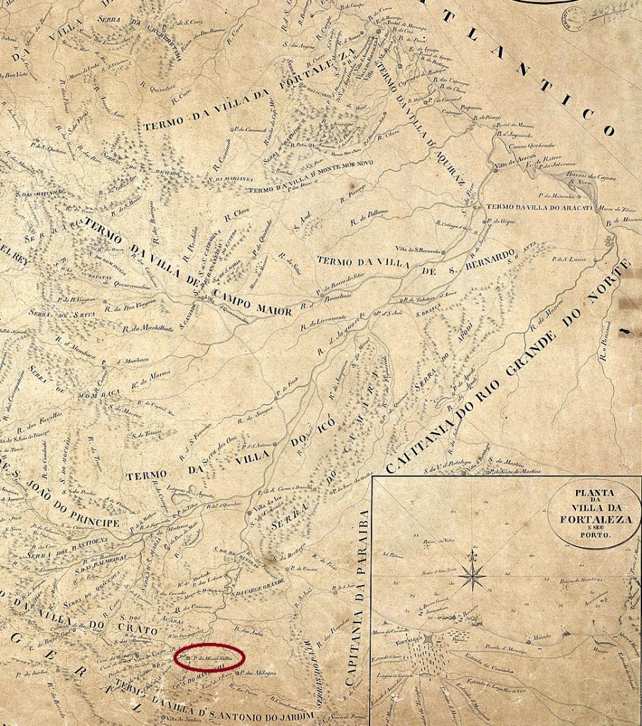
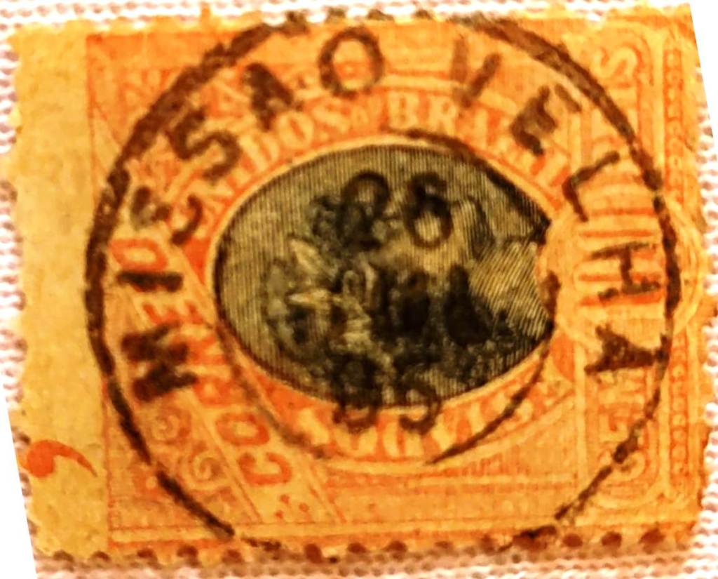
Originally, the place was called Missão dos Cariris Novos, located near the southern bank of the Rio Salgado and 500 kilometres south of the future provincial capital Fortaleza. In January 1748, it was named Freguesia de São José da Missão Velha. From August 1763, it belonged to Vila do Crato and from August 1846 to Vila de Barbalha. In November 1864, Missão Velha became an independent vila and has been a town since July 1931.
As R. Koester writes in Carimbologia XXVII, there has been a post office there since November 1837. The only imperial postmark to date is MCE-0225b (Fig. J.L. Pedreira):
MCE-0225b (JLP) 1882-1895Villiers de l’Ile Adam: Carta (…) da Provincia do Ceará, 1849
Andere Namen: Missão dos Cariris Novos
Ursprünglich hieß der Ort Missão dos Cariris Novos, lag nah am Südufer des Rio Salgado und befand sich 500 Kilometer südlich der späteren Provinzhauptstadt Fortaleza. Im Januar 1748 erfolgte die Ernennung zur Freguesia de São José da Missão Velha. Ab August 1763 gehörte sie zur Vila do Crato und ab August 1846 zur Vila de Barbalha. Im November 1864 wurde Missão Velha eine selbstständige Vila und ist seit Juli 1931 eine Stadt.
Wie R. Koester in Carimbologia XXVII schreibt, gab es dort seit November 1837 ein Postamt. Der bisher einzige kaiserliche Poststempel ist MCE-0225b (Abb. J.L. Pedreira):
Villiers de l’Ile Adam: Carta (…) da Provincia do Maranhão, 1850
Other names: São José do Periá, Humberto de Campos (1934)
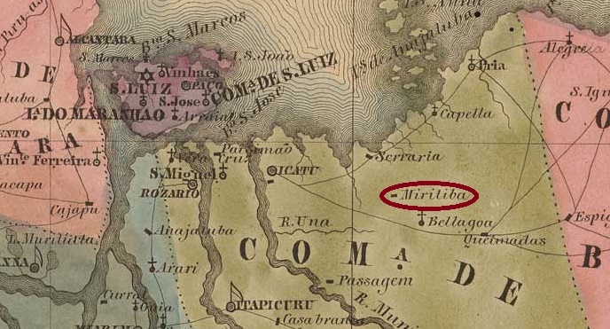
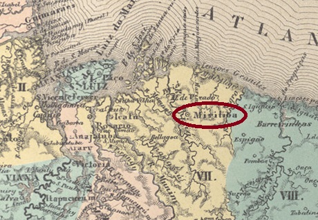
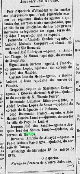
The place was originally called Arraial de São José do Periá and was located on the west bank of the Rio Periá, 180 kilometres east of the later provincial capital São Luís do Maranhão. In May 1835, it became a parish of the Vila de Icatu. In July 1859, it was elevated to the status of a vila under the name Miritiba de São José do Periá. Since December 1934, the town has been called Município de Humberto de Campos in honour of the politician, journalist and writer (1886–1934) who was born in Miritiba. The word ‘Miritiba’ comes from the Tupi language and means ‘many reeds’.
Humberto de Campos, in 1926 (Correio da Manhã)
As reported by the regional press, there had been a post office there since February 1875:
Diario do Maranhão, 25 March 1875
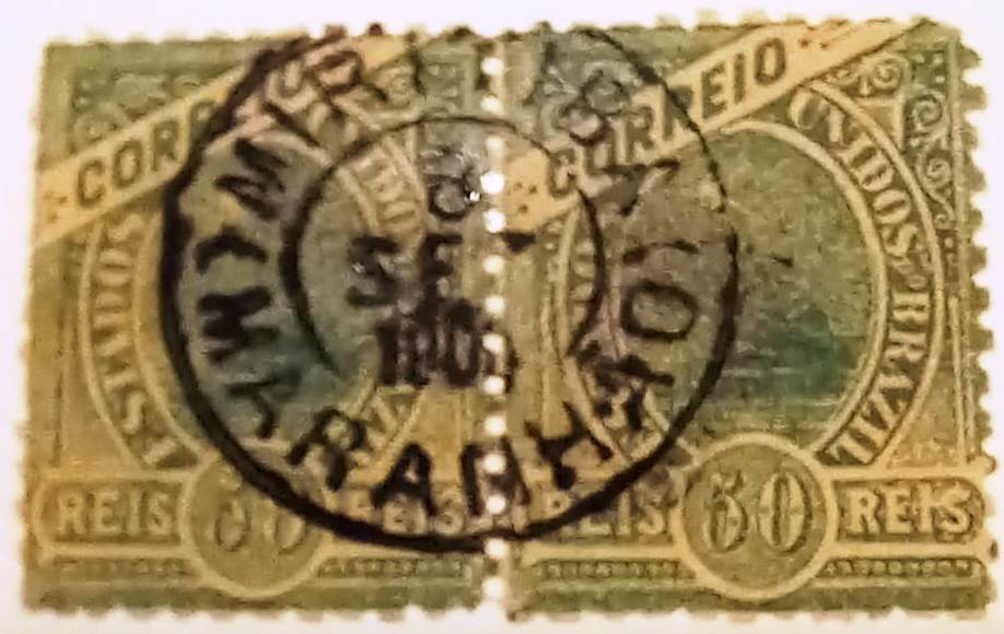
The oldest postmark to date, MMA-0165b (Fuad Ferreira Fo. collection), already bears a date from the Republic:
MMA-0165b (FF) 1904Atlas do Imperio do Brasil, 1868
Andere Namen: São José do Periá, Humberto de Campos (1934)
Der Ort hieß ursprünglich Arraial de São José do Periá und lag am Westufer des Rio Periá, 180 Kilometer östlich der späteren Provinzhauptstadt São Luís do Maranhão. Im Mai 1835 wurde er zur Freguesia der Vila de Icatu. Im Juli 1859 erfolgte der Aufstieg zur Vila unter dem Namen Miritiba de São José do Periá. Seit Dezember 1934 trägt der Ort den Namen Município de Humberto de Campos zu Ehren des Politikers, Journalisten und Schriftstellers (1886–1934), der in Miritiba geboren wurde. Das Wort „Miritiba” kommt aus dem Tupi und bedeutet „viele Schilfröhrchen”.
Humberto de Campos, 1926 (Correio da Manhã)
Wie die regionale Presse bekannt gab, gab es dort seit Februar 1875 ein Postamt:
Diario do Maranhão, 25.03.1875
Der bisher älteste Poststempel MMA-0165b (Samml. Fuad Ferreira Fo.) trägt bereits ein Datum der Republik:
Villiers de l’Ile Adam: Carta (…) da Provincia do Mato Grosso, 1850
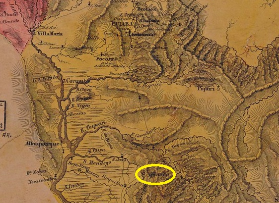
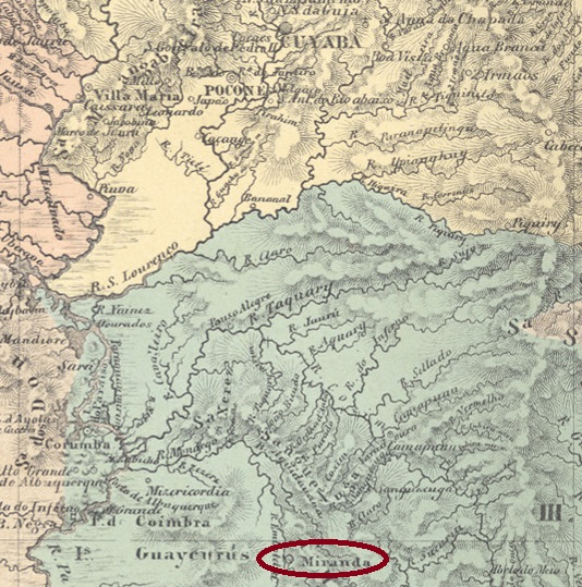
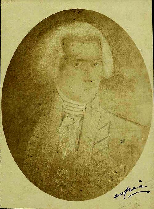
The Nossa Senhora do Carmo do Rio Mondego prison was built in July 1778 on the east bank of the Mondego River (now Miranda), 810 kilometres south of what would later become the provincial capital of Cuiabá. In August 1835, the village was declared Freguesia de Nossa Senhora do Carmo de Miranda in the territory of Vila de Corumbá. This was followed by two promotions to Vila in May 1857 and October 1871, as Miranda had been downgraded to Freguesia again in November 1869 at the end of the war against Paraguay. Since July 1918, Miranda has been a city, which has been in the state of Mato Grosso do Sul since January 1979. The place name commemorates the Portuguese Caetano Pinto de Miranda Montenegro (1748–1827), Marquês de Vila Real de Praia Grande, who was governor of the Captaincy of Mato Grosso from 1796 to 1803.
Miranda Montenegro (Wikipedia)
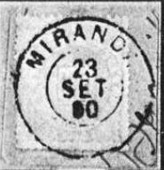
Two dates of origin have been found for the local post office: first in June 1850, as R. Koester writes in Carimbologia XXVII, then again in October 1853, as noted in Nova Monteiro’s Administrações e Agencias Postaes do Brasil Imperio (Brasil Filatelico/RJ, 1934–1935; reprinted SPP 1994–1999).
The only imperial postmark to date is MMT-0040b (Fig. Koster, op. cit.):
MMT-0040b (RK) 1883-1890Atlas do Imperio do Brasil, 1868
Das Gefängnis Nossa Senhora do Carmo do Rio Mondego wurde im Juli 1778 am Ostufer des Flusses Mondego (heute Miranda) erbaut, 810 Kilometer südlich der späteren Provinzhauptstadt Cuiabá. Im August 1835 wurde die Ortschaft als Freguesia de Nossa Senhora do Carmo de Miranda im Gebiet der Vila de Corumbá erklärt. Es folgten zwei Aufstiege zur Vila im Mai 1857 und im Oktober 1871, da Miranda im November 1869, am Ende des Krieges gegen Paraguay, wieder zur Freguesia herabgestuft wordem war. Seit Juli 1918 ist Miranda eine Stadt, die seit Januar 1979 im Bundesstaat Mato Grosso do Sul liegt. Der Ortsname erinnert an den Portugiesen Caetano Pinto de Miranda Montenegro (1748–1827), Marquês de Vila Real de Praia Grande, der von 1796 bis 1803 Gouverneur der Kapitanerie von Mato Grosso war.
Miranda Montenegro (Wikipedia)
Für das örtliche Postamt wurden zwei Entstehungsdaten gefunden: erstmals im Juni 1850, wie R. Koester in Carimbologia XXVII schreibt, dann wieder im Oktober 1853, wie in Nova Monteiros Administrações e Agencias Postaes do Brasil Imperio (Brasil Filatelico/RJ, 1934–1935; Nachdruck SPP 1994–1999) vermerkt.
Der bisher einzige kaiserliche Poststempel ist MMT-0040b (Abb. Koster, op. cit.):
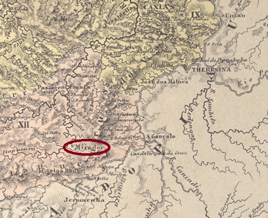
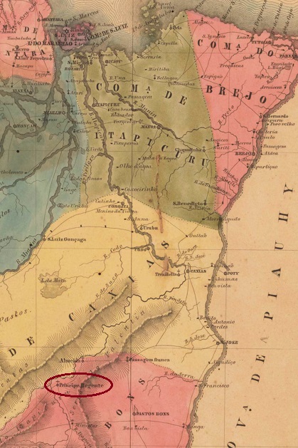
Arraial do Príncipe Regente was founded around 1820 on the Itapecuru River, 490 km south of the future provincial capital São Luís do Maranhão. On old maps, the settlement is located on the east bank, but today it lies on the west bank. The crown prince (Príncipe Regente) here is the Brazilian emperor Dom Pedro I, who later became the Portuguese king Dom Pedro IV. Under this name, it was elevated to the status of a vila in June 1855, which became a district of Vila de Pastos Bons in September 1861. In June 1866, it was renamed Freguesia de S. Bento do Mirador, which became a municipality in July 1870 and a town in 1938. According to local legend, the place name Mirador comes from a short-sighted resident. However, it is more likely that the name means ‘viewpoint’ and refers to a hill along the Itapecuru.
In Carimbologia XXVII, R. Koester mentions two dates for the establishment of the local post office: in October 1872 and in 1879. The first date is confirmed in the postal report (Relatorio dos Correios) for 1886, and postal activities are documented for 1874 and 1875. In this respect, the second date – if correct – refers to a reopening.
No imperial postmark from Mirador has been found to date.
Villiers de l’Ile Adam: Carta (…) da Provncia do Maranhão, 1850
Andere Namen: Principe Regente
Der Arraial do Príncipe Regente entstand um 1820 am Fluss Itapecuru, 490 km südlich der späteren Provinzhauptstadt São Luís do Maranhão. Auf alten Karten liegt die Siedlung am Ostufer, heute liegt sie jedoch am Westufer. Der Kronprinz (Príncipe Regente) ist hier der brasilianische Kaiser Dom Pedro I., der später der portugiesische König Dom Pedro IV. wurde. Unter diesem Namen erfolgte im Juni 1855 der Aufstieg zur Vila, die im September 1861 ein Distrikt der Vila de Pastos Bons wurde. Im Juni 1866 erfolgte die Umbenennung in Freguesia de S. Bento do Mirador, die im Juli 1870 zur Gemeinde und 1938 zur Stadt wurde. Einer lokalen Legende zufolge stammt der Ortsname Mirador von einem kurzsichtigen Bewohner. Wahrscheinlicher ist jedoch, dass der Name Aussichtspunkt bedeutet und sich auf eine Anhöhe entlang des Itapecuru bezieht.
R. Koester nennt in Carimbologia XXVII zwei Zeitpunkte für die Entstehung des örtlichen Postamts: Oktober 1872 bzw. 1879. Der erste Termin wird im Postbericht (Relatorio dos Correios) für 1886 bestätigt und es sind Postaktivitäten für 1874 und 1875 belegt. Insofern handelt es sich beim zweiten Termin – falls er korrekt ist – um eine Wiedereröffnung.
Bisher wurde kein kaiserlicher Poststempel aus Mirador gefunden.
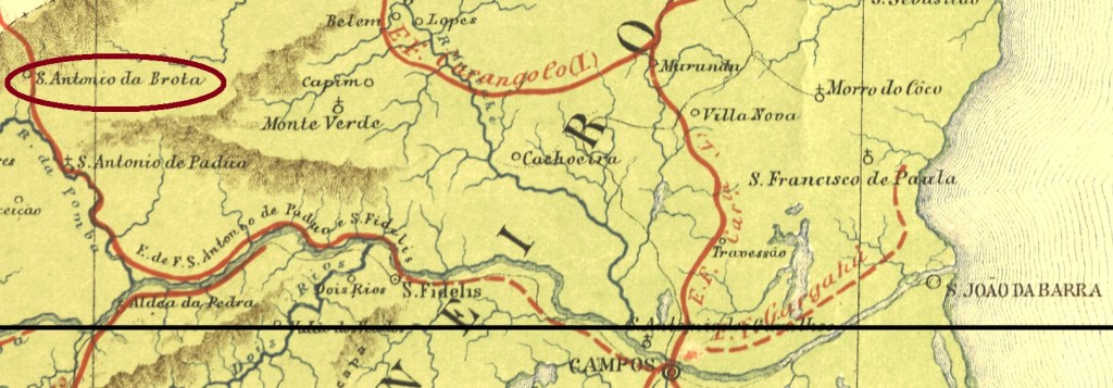
See also Brotos (BRJ-1565) and Santo Antonio dos Brotos (SRJ-1565)
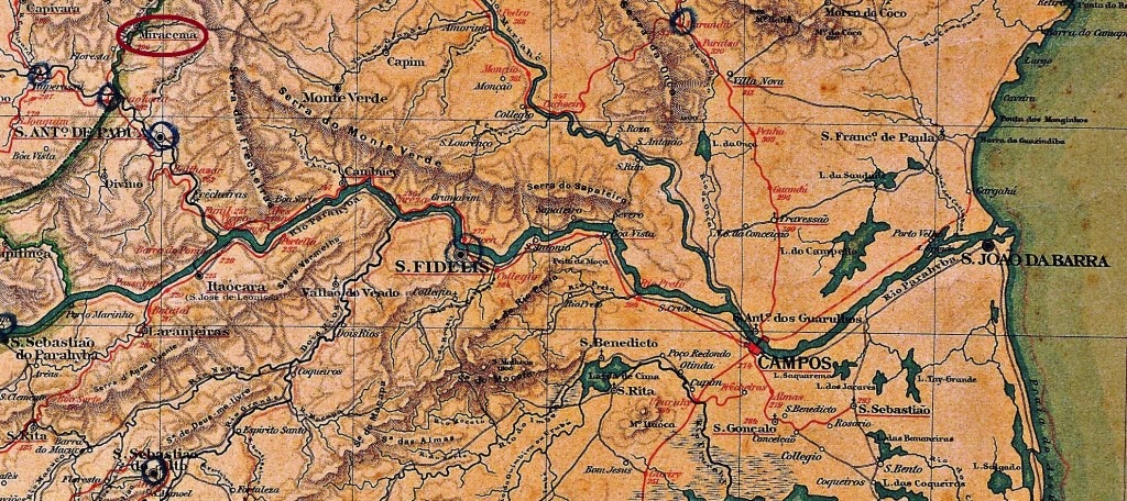
Santo Antonio dos Brotos (also written das Brotas or da Brota) was a district of São Fidellis, situated almost 300 km north of the imperial capital Rio de Janeiro. In March 1883 the place name changed to Miracema, which emancipated as an own municipality in November 1935.
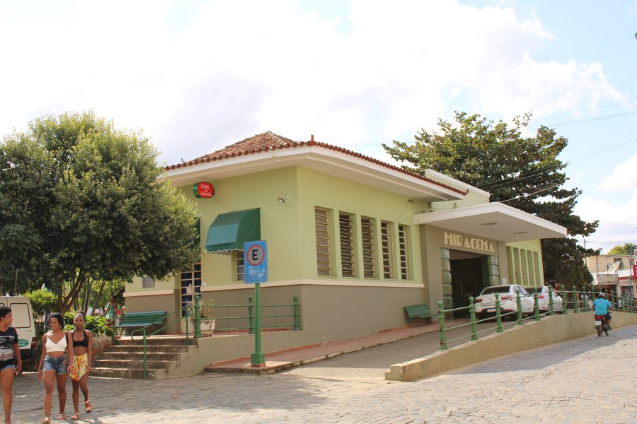
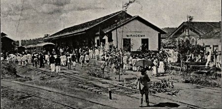
Miracema Station was opened in August 1883 by the Estrada de Ferro Sto. Antonio de Pádua railway company (Campos–Miracema line) and belonged to the municipality of Sto. Antonio de Pádua. The railway line changed hands in 1884 and was transferred to E.F. Macaé e Campos. From 1887 until its closure in 1970, it belonged to E.F. Leopoldina (estacoesferroviarias.com.br). Today, the tracks have been removed and the station building is used as a bus station.
In 1917 (Fon-Fon, on estacoesferroviarias.com.br)In June 2021 (photo: Júlio Alves, estacoesferroviarias.com.br)
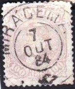
According to P. Novaes (agenciaspostais.com.br), the station post office was opened in January 1884. The old post office in the village remained in operation until August 1885. The imperial postmark is MRJ-1700a (image from the Internet) and bears the curious accent error ‘Mirácema’:
MRJ-1700a (EB) 1884–1889E.F. Central do Brasil, 1890
Siehe auch Brotos (BRJ-1565), Santo Antonio dos Brotos (SRJ-1565)
Santo Antonio dos Brotos (auch das Brotas oder da Brota geschrieben) war ein Distrikt von São Fidellis, der fast 300 km nördlich der kaiserlichen Hauptstadt Rio de Janeiro entfernt lag. Im März 1883 wechselte der Ortsname zu Miracema, der zu einer Stadt im eigenen Município im November 1935 aufstieg.
Der Bahnhof Miracema wurde im August 1883 von der Eisenbahngesellschaft Estrada de Ferro Sto. Antonio de Pádua (Linie Campos–Miracema) eröffnet und gehörte nun zum Munizipium de Sto. Antonio de Pádua. Die Bahnlinie wechselte 1884 den Besitzer und ging an die E.F. Macaé e Campos über. Von 1887 bis zur Stilllegung im Jahr 1970 gehörte sie der E.F. Leopoldina (estacoesferroviarias.com.br). Heute sind die Gleise entfernt, das Bahnhofsgebäude wird als Busbahnhof genutzt.
Im Jahr 1917 (Fon-Fon, auf estacoesferroviarias.com.br)Im Juni 2021 (Foto: Júlio Alves, estacoesferroviarias.com.br)
Das Bahnhofspostamt wurde laut P. Novaes (agenciaspostais.com.br) im Januar 1884 eröffnet. Das alte Postamt im Dorf blieb bis August 1885 in Betrieb. Der kaiserliche Poststempel ist MRJ-1700a (Abb. aus dem Internet) und trägt den kuriosen Akzentfehler „Mirácema”: