Categories
Carimbologia A-B

Belem (train station/Bahnhof – E.F. D. Pedro II), Rio de Janeiro (BRJ-0155)

Atlas do Imperio do Brasil, 1868

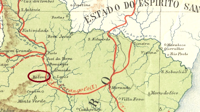
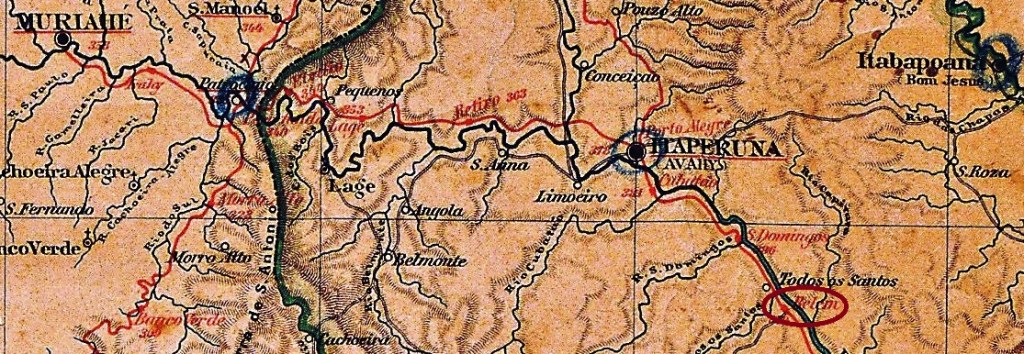
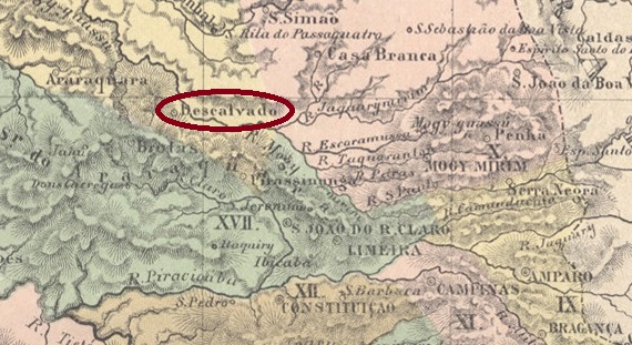
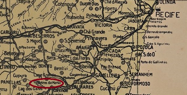
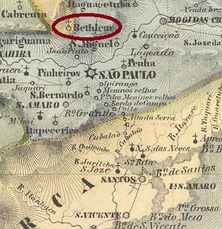
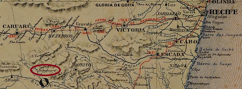
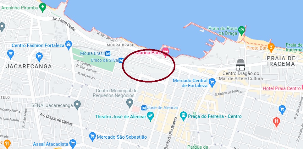
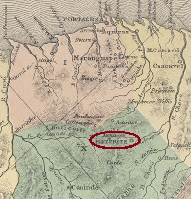
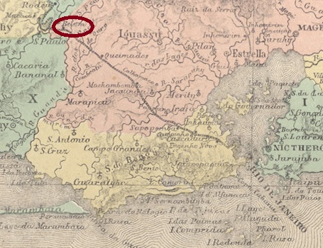
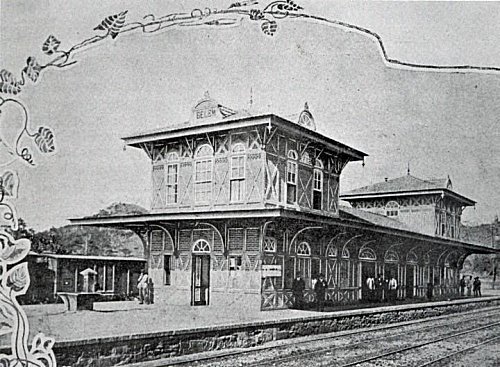
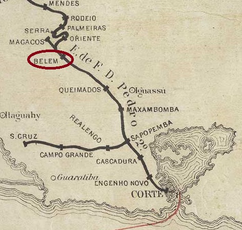
Belém station was inaugurated in May 1859 by the state railway company E.F. D. Pedro II (Main Line), located close to the north bank of the Guandu river in the Município of Iguassú, 80 km northwest of the capital Rio de Janeiro.

Jornal do Commercio, 29.05.1859

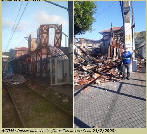
The railway line went to E.F. Central do Brasil in 1889 and to Rede Ferroviária Federal S.A. in 1975 (estacoesferroviárias.com.br). Since 1997 it has been operated by the Supervia consortium. The station building was destroyed by fire in 2020.

1928 (Photo : Eduardo G. David in estacoesferroviarias.com.br)
2020 (Photo : Zilmar Reis in estacoesferroviarias.com.br)

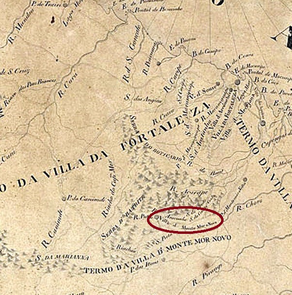
The area around the station went to the municipio of Nova Iguaçu in November 1916. The resulting settlement became the district of Belfort Roxo in December 1938, renamed Japeri in April 1952. Since December 1991, Japeri has been an independent município.

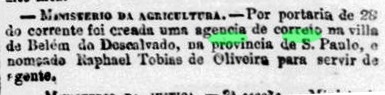
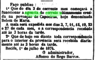
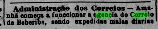
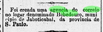
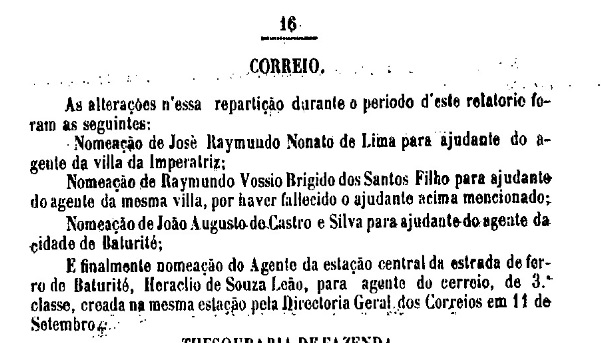
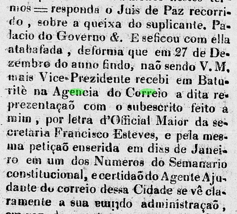
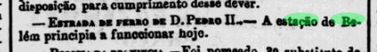
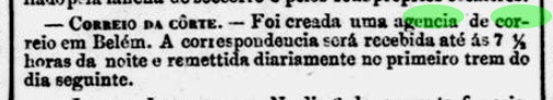
Two dates of creation for the station post office have been found. First in 1859, as listed in the Directory of Imperial Post Offices (Tabella das Agencias do Correio do Imperio, Rio de Janeiro, 1885). Then in June 1865, as Nova Monteiro writes in Administrações e Agencias Postaes do Brasil Imperio (Brasil Filatelico/RJ, 1934-5; Reprint SPP 1994-1999). There is confirmation of the earlier date from the capital press, a few days before the inauguration of the station:

Jornal do Commercio, 25.05.1859

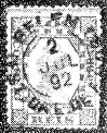
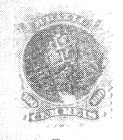
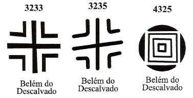
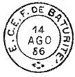
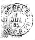
At least four postmarks from this station are seen in the 19th century. The first one is BRJ-0155a, which was used until at least 1876, also occurs in purple and is known under Paulo Ayres (Catálogo de Carimbos Brasil-Império, S. Paulo, 1937, 1942) with no. 1235:

BRJ-0155a (P.A. 1235) 1859-1876ff

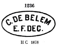
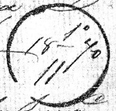
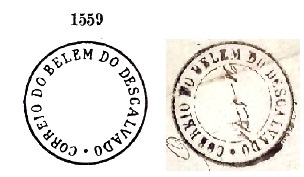
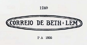
It was followed by BRJ-0155b (Fig. Claudio Coelho): a double circle with the inscriptions BELEM above and (E) below. The only specimen is dated 1880 in the centre. The other postmarks have been presented by R. Koester in Carimbologia IV:

BRJ-0155c (RK) 1883ff-1886
BRJ-0155d (RK) 1890-1895
Estações (…) do Rio de Janeiro, São Paulo e Minas Geraes (1880)

Der Bahnhof Belém wurde im Mai 1859 durch die staatliche Bahngesellschaft E.F. D. Pedro II (Hauptlinie) eingeweiht und lag nah am Nordufer des Flusses Guandu im Município von Iguassú, 80 km nordwestlich der Hauptstadt Rio de Janeiro entfernt.

Jornal do Commercio, 29.05.1859

Die Bahnlinie ging 1889 an die E.F. Central do Brasil und 1975 an die Rede Ferroviária Federal S.A. (estacoesferroviárias.com.br). Seit 1997 wird sie vom Konsortium Supervia betrieben. Das Bahnhofsgebäude wurde 2020 durch Brand zerstört.

1928 (Foto : Eduardo G. David in estacoesferroviarias.com.br)
2020 (Foto : Zilmar Reis in estacoesferroviarias.com.br)

Das Gebiet um den Bahnhof ging im November 1916 zum Municipio von Nova Iguaçu. Die entstandene Siedlung wurde im Dezember 1938 zum Distrikt von Belfort Roxo, die im April 1952 zu Japeri umbenannt ist. Seit Dezember 1991 ist Japeri ein eigenständiger Município.

Zwei Gründungszeitpunkte fürs Bahnhofspostamt wurden gefunden. Erstmals 1859, wie im Verzeichnis der kaiserlichen Postämter (Tabella das Agencias do Correio do Imperio, Rio de Janeiro, 1885) aufgelistet. Dann im Juni 1865, wie Nova Monteiro in Administrações e Agencias Postaes do Brasil Imperio (Brasil Filatelico/RJ, 1934-5; Reprint SPP 1994-1999) schreibt. Vom früheren Datum gibt es eine Bestätigung durch die Hauptstadtpresse, wenige Tage vor der Einweihung des Bahnhofs:

Jornal do Commercio, 25.05.1859

Zumindest vier Poststempel aus diesem Bahnhof sind im 19. Jahrhundert zu sehen. Erstens BRJ-0155a, der bis mindestens 1876 verwendet wurde, auch in lila vorkommt und unter Paulo Ayres (Catálogo de Carimbos Brasil-Império, S. Paulo, 1937, 1942) mit Nr. 1235 bekannt ist:

BRJ-0155a (P.A. 1235) 1859-1876ff

Ihm folgte BRJ-0155b (Abb. Claudio Coelho): ein Doppelkreis mit den Inschriften BELEM oben und (E) unten. Das einzige Exemplar ist 1880 in der Mitte datiert. Die weiteren Poststempel sind von R. Koester in Carimbologia IV vorgestellt worden:

BRJ-0155c (RK) 1883ff-1886
BRJ-0155d (RK) 1890-1895

Categories
Carimbologia A-B

Belem (train station/Bahnhof – E.F. de Carangola), Rio de Janeiro (BRJ-0154)

Estrada de Ferro Central do Brasil, 1890

Belém station was inaugurated in August 1880 by the E.F. do Carangola railway company and was located on the west bank of the Muriaé River in the município of Campos, 320 km northeast of the capital Rio de Janeiro. The railway line changed to the E.F. Leopoldina in 1890 and belonged to Rede Ferroviária Federal S.A. (estacoesferroviarias.com.br) from 1975 until its closure. The area around the station went to the Vila of Natividade de Itaperuna in November 1885, which became the município of Itaperuna in December 1889. The station was probably decommissioned in 1899, the rails having long since disappeared.

As can be read in the Directory of Imperial Post Offices (Tabella das Agencias do Correio do Imperio, Rio de Janeiro, 1885), there was a post office in the station since 1880, which was closed in May 1899, as Paulo Novaes (agenciaspostais.com.br) writes. The corresponding postmark is BRJ-0154a, found so far with dates from 1880 to 1881 and registered in Paulo Ayres’ Catálogo de Carimbos Brasil-Império, (S. Paulo, 1937, 1942) under no. 1236:

BRJ-0154a (P.A. 1236)
Almanak Laemmert, 1892

Der Bahnhof Belém wurde im August 1880 durch die E.F. do Carangola-Bahngesellschaft eingeweiht und lag am Westufer des Muriaé-Flusses im Município von Campos, 320 km nordöstlich der Hauptstadt Rio de Janeiro. Die Bahnlinie wechselte 1890 zur E.F. Leopoldina und gehörte von 1975 bis zur Stilllegung der Rede Ferroviária Federal S.A. (estacoesferroviarias.com.br). Das Gebiet um den Bahnhof ging im November 1885 zur Vila von Natividade de Itaperuna, die im Dezember 1889 der Município von Itaperuna wurde. Der Bahnhof wurde vermutlich 1899 außer Betrieb gesetzt, die Schienen sind schon längst verschwunden.

Wie im Verzeichnis der kaiserlichen Postämter /Tabella das Agencias do Correio do Imperio, Rio de Janeiro, 1885) zu lesen ist, gab es im Bahnhof ein Postamt seit 1880, das im Mai 1899 geschlossen wurde, wie Paulo Novaes (agenciaspostais.com.br) schreibt. Der Poststempel dazu ist BRJ-0154a, der bisher mit Daten von 1880 bis 1881 gefunden wurde und im Paulo Ayres‘ Catálogo de Carimbos Brasil-Império, (S. Paulo, 1937, 1942) unter Nr. 1236 registriert wurde:

BRJ-0154a (P.A. 1236)
Categories
Carimbologia A-B

Belem do Descalvado, São Paulo (BSP-0145)

Atlas do Imperio do Brasil, 1868

Another name: Descalvado (1908)

The chapel of N. Sra. de Belém was built in 1832 and was located on the west bank of the Bonito River at the Vila of Araraquara, 240 km north of the provincial capital of São Paulo. The village was elevated to Freguesia in February 1844 and passed to the Município of Rio Claro the following year. In April 1864, it was promoted to Vila in its own Município, and in April 1889, it became a town, simply called Descalvado since December 1908.

In June 1865 came the official decree for a post office on site, as reported in the capital press:

Jornal do Commercio/RJ, 30/06/1865

The first postmark is BSP-0145a, which also occurs in blue and dark purple, was used until about 1874 and is also known by Paulo Ayres in Catálogo de Carimbos Brasil-Império (S. Paulo, 1937, 1942) under No. 1559. However, his illustration lacks the inner circle, when compared to the original:

BSP-0145a (P.A. 1559, recte FF)

It was followed by the emergency or transitional solution BSP-0145b, used from 1870 to 1877 and already shown by R. Koester in Carimbologia IV.

BSP-0145b (RK)

James Dingler and Klerman W. Lopes reported three mute cancellations from Belém do Descalvado, which were given the nos. BPA 3233, 3235 and 4325 in Mute Cancellations of the Brazil Empire / Carimbos Mudos do Brasil Império (Brazil Philatelic Association, Rio de Janeiro, 2000):

BPA 3233 – 3235 (P.A. 411, 1869, also in blue) – 4325

Another mute cancel was presented by R. Koester (op. cit.):

1873 (RK)

From about 1878 onwards, local postmarks bore the place name DESCALVADO.

Villiers de l’Ile Adam: Carta (…) da Provincia de São Paulo, 1847

Anderer Name: Descalvado (1908)

Die Kapelle von N. Sra. de Belém wurde 1832 errichtet und lag am Westufer des Flusses Bonito bei der Vila von Araraquara, 240 km nördlich der Provinzhauptstadt São Paulo entfernt. Die Ortschaft wurde zu Freguesia im Februar 1844 erhoben und ging im folgenden Jahr zum Município von Rio Claro. Im April 1864 erfolgte der Aufstieg zur Vila im eigenen Município, und im April 1889 die Ernennung zur Stadt, die seit Dezember 1908 einfach Descalvado heißt.

Im Juni 1865 kam die behördliche Verfügung über ein Postamt vor Ort, wie die Hauptstadtpresse berichtete:

Jornal do Commercio/RJ, 30.06.1865

Der erste Poststempel ist BSP-0145a, der bis ca. 1874 auch in Blau und Dunkellila Verwendung fand und auch durch Paulo Ayres in Catálogo de Carimbos Brasil-Império (S. Paulo, 1937, 1942) unter Nr. 1559 bekannt ist. Allerdings fehlt in seiner Abbildung der innere Kreis, wie man gegenüber dem Original sehen kann:

BSP-0145a (P.A. 1559, recte FF)

Ihm folgte die Not- oder Übergangslösung BSP-0145b, die von 1870 bis 1877 gebraucht und bereits durch R. Koester in Carimbologia IV gezeigt wurde.

BSP-0145b (RK)

Aus Belém do Descalvado meldeten James Dingler und Klerman W. Lopes drei stumme Abstempelungen, die in Mute Cancellations of the Brazil Empire / Carimbos Mudos do Brasil Império (Brazil Philatelic Association, Rio de Janeiro, 2000) die Nr. BPA 3233, 3235 und 4325 bekamen:

BPA 3233 – 3235 (P.A. 411, 1869, auch in Blau) – 4325

Einen weiteren stummen Stempel stellte R. Koester (op. cit.) vor:

1873 (RK)

Ab ca. 1878 trugen die Poststempel die Ortsbezeichnung DESCALVADO.

Categories
Carimbologia A-B

Belem de Maria, Pernambuco (BPE-0085)

Carta Corographica da Provincia de Pernambuco,1880

Text update of April 3, 2023

Another name: Capoeiras

Belém de Maria was originally a small settlement called Capoeiras (Scrub), belonging to the Freguesia of Catende in the Município of Palmares, located on the south bank of the Panelas River, 150 km southwest of the provincial capital Recife. The place rose to freguesia in July 1909, to district in September 1930 and to município in December 1958.

According to different sources, the local post office was created in 1873, but it did not start operating until July of the following year, as the regional press reported:

Diario de Pernambuco, 02.07.1874

The imperial postmark from this locality is the French type BPE-0085a (Coll. Fuad Ferreira Fo.) A double circle with the inscription BELEM DE MARIA above and the small star between brackets below. The date had to be entered by hand, in the only specimen so far shows the year 1885.

Arthur D. Ribeiro: Estado de Pernambuco (1924)

Textaktualisierung vom 3. April 2023

Anderer Name: Capoeiras

Belém de Maria war ursprünglich eine kleine Siedlung namens Capoeiras (Gestrüpp), die zur Freguesia von Catende im Município von Palmares gehörte und am Südufer des Flusses Panelas lag, 150 km südwestlich der Provinzhauptstadt Recife entfernt. Der Ort stieg im Juli 1909 zur Freguesia, im September 1930 zum Distrikt und im Dezember 1958 zum Município auf.

Nach übereinstimmenden Quellen gab es dort ein Postamt seit 1873, das allerdings erst im Juli des Folgejahres seinen Betrieb aufnahm, wie die Regionalpresse berichtete:

Diario de Pernambuco, 02.07.1874

Der kaiserliche Poststempel aus dieser Ortschaft ist der französische Typus BPE-0085a (Samml. Fuad Ferreira Fo.) Ein Doppelkreis mit der Inschrift BELEM DE MARIA oben und dem kleinen Stern zwischen Klammern unten. Das Datum musste per Hand eingetragen werden, im bisher einzigen Exemplar war das Jahr 1885 zu sehen.

Categories
Carimbologia A-B

Bethlem (de Jundiahy), São Paulo (BSP-0140)

Atlas do Imperio do Brasil, 1868

Another name: Itatiba

The Freguesia of N. Sra. de Bethlem was founded in December 1830 in the Município of Jundiaí and was located on the south bank of the river Atibaia, 80 km north of the provincial capital São Paulo. The place became a vila in February 1857 and a town in March 1876, renamed Itatiba a year later, probably to avoid confusion with places of the same name. The word from the Tupi-Guarany language means many stones.

As Nova Monteiro writes in Administrações e Agencias Postaes do Brasil Imperio (Brasil Filatelico/RJ, 1934-5; Reprint SPP 1994-1999), there had been a post office there since November 1859. The only imperial postmark with this place name so far is BSP-0140a, used between 1859 and 1876 and already known from Paulo Ayres’ Catálogo de Carimbos Brasil-Império (S. Paulo, 1937, 1942) with no. 1240:

BSP-0140a (P.A. 1240)

Later postmarks (from around 1878) already bear the place name Itatiba (see Koester: Carimbologia XXIV).

Villiers de l’Ile Adam: Carta (…) da Provincia de São Paulo, 1847

Anderer Name: Itatiba (1877)

Die Freguesia von N. Sra. de Bethlem wurde im Dezember 1830 im Município von Jundiaí gegründet und lag am Südufer des Flusses Atibaia, 80 km nördlich der Provinzhauptstadt São Paulo entfernt. Der Ort wurde im Februar 1857 eine Vila und im März 1876 eine Stadt, die ein Jahr später zu Itatiba umbenannt wurde, wohl um Verwechslungen mit gleichnamigen Orten zu vermeiden. Das Wort aus der Tupi-Guarany-Sprache bedeutet viele Steine.

Wie Nova Monteiro in Administrações e Agencias Postaes do Brasil Imperio (Brasil Filatelico/RJ, 1934-5; Reprint SPP 1994-1999) schreibt, gab es dort ein Postamt seit November 1859. Der bisher einzige kaiserliche Poststempel mit diesem Ortsnamen ist BSP-0140a, der zwischen 1859 und 1876 verwendet wurde und bereits durch Paulo Ayres‘ Catálogo de Carimbos Brasil-Império (S. Paulo, 1937, 1942) mit Nr. 1240 bekannt ist:

BSP-0140a (P.A. 1240)

Spätere Poststempel (ab ca. 1878) tragen bereits den Ortsnamen Itatiba (s. Koester: Carimbologia XXIV)

Categories
Carimbologia A-B

Beberibe, Pernambuco (BPE-0080)

Atlas do Imperio do Brasil, 1868

The chapel of Sto. Antonio da Agua Fria de Beberibe (Saint Anthony of the Cold Water from the Beberibe) was built in the 19th century near the Vila of Olinda and was located on the south bank of the Beberibe River, only 8 km north of the provincial capital Recife. The village became a district in June 1908, changed to the Município of Recife in September 1928 and has been an administrative zone of the metropolis since 1988.

Two dates of origin for the local post office have been found. First in 1875, according to the postal report (Relatorio Postal) of 1886. Then again in 1882, according to a regional press report:

Diario de Pernambuco, 13.09.1882

So far, no imperial-era postmark from Beberibe has been seen.

Carta Corographica da Provincia e Pernambuco, 1880

Die Kapelle von Sto. Antonio da Agua Fria de Beberibe (Heiliger Antonius des Kalten Wassers aus dem Beberibe) wurde im 19. Jahrhundert bei der Vila von Olinda errichtet und lag am Südufer des Beberibe-Flusses, nur 8 km nördlich der Provinzhauptstadt Recife. Der Ort wurde im Juni 1908 zum Distrikt, wechselte im September 1928 zum Município von Recife und ist seit 1988 eine Verwaltungszone der Metropole.

Zwei Entstehungsdaten fürs örtliche Postamt wurden gefunden. Erstmals 1875, wie im Postbericht (Relatorio Postal) von 1886 zu lesen ist. Dann wieder 1882, laut regionalem Pressebericht:

Diario de Pernambuco, 13.09.1882

Bisher war kein Poststempel aus der Kaiserzeit aus Beberibe zu sehen.

Categories
Carimbologia A-B

Bebedouro, São Paulo (BSP-0135)

Estado de São Paulo, 1910

The chapel of S. João Baptista da Boa Vista do Bebedouro was built in May 1884, it was in the Município of Jaboticabal, 380 km northwest of the provincial capital São Paulo. It became a district in September 1892, a vila in July 1894 and a town in March 1899.

Reinhold Koester writes in Carimbologia IV that there had been a post office there since October 1888. Nevertheless, the correct date is probably a month later, as can be read from the Rio press:

Diario de Noticias/RJ, 10.11.1888

The oldest postmark so far is BSP-0135a (image: Mário Celso Orsi Jr.): a double circle with the inscriptions BEBEDOURO above (between four-pointed stars) and S. PAULO below. The dates inside were seen for the period 1897-1901.

Mappa Geral do Brasil, 1911

Die Kapelle von S. João Baptista da Boa Vista do Bebedouro wurde im Mai 1884 errichtet, sie lag im Município von Jaboticabal, 380 km nordwestlich der Provinzhauptstadt São Paulo. Der Ort wurde im September 1892 zur Distrikt, im Juli 1894 zur Vila und im März 1899 zur Stadt.

Reinhold Koester schreibt in Carimbologia IV, dass es dort seit Oktober 1888 ein Postamt gab. Das richtige Datum dürfte dennoch ein Monat später sein, wie aus der Presse aus Rio zu lesen ist:

Diario de Noticias/RJ, 10.11.1888

Der älteste Poststempel bisher ist BSP-0135a (Abb. Mário Celso Orsi Jr.): ein Doppelkreis mit den Inschriften BEBEDOURO oben (zwischen vierzackigen Sternen) und S. PAULO unten. Die Daten im Inneren wurden für den Zeitraum 1897-1901 gesehen.

Categories
Carimbologia A-B

Bebedouro, Pernambuco (BPE-0075)

Atlas do Imperio do Brasil, 1868

Another name: Agrestina (1943)

The Freguesia of Sto. Antonio do Bebedouro was created in June 1884 and was located close to the north bank of the Una River in the Município of Altinho, 150 km west of the provincial capital Recife. In July 1909, the village was elevated to the status of Vila, and since December 1943, the Município has been called Agrestina.

The postal agency of the village was listed in the Directory of Imperial Post Offices (Tabella das Agencias do Correio do Imperio, Rio de Janeiro, 1885) with year of origin 1876. The imperial postmark is the French type BPE-0075a (Coll. Marco Morel): A double circle with the inscription BEBEDOURO above and the star between brackets below. As so often in the province of Pernambuco, the date had to be entered by hand, which was often enough omitted. The postmark has so far been seen on numeral issues of 1885 and 1888.

Carta Corographica da Provincia de Pernambuco, 1880

Anderer Name: Agrestina (1943)

Die Freguesia von Sto. Antonio do Bebedouro wurde im Juni 1884 ins Leben gerufen und lag nah am Nordufer des Flusses Una im Município von Altinho, 150 km westlich der Provinzhauptstadt Recife. Im Juli 1909 wurde der Ort zur Vila erhoben, seit Dezember 1943 heißt der Município Agrestina.

Die Postagentur des Ortes wurde im Verzeichnis der kaiserlichen Postämter (Tabella das Agencias do Correio do Imperio, Rio de Janeiro, 1885) mit Entstehungsjahr 1876 aufgelistet. Der kaiserliche Poststempel ist der französische Typus BPE-0075a (Samml. Marco Morel): Ein Doppelkreis mit der Inschrift BEBEDOURO oben und dem Stern zwischen Klammern unten. Wie so oft in der Provinz Pernambuco, musste das Datum per Hand eingetragen werden, was oft genug ausblieb. Der Poststempel wurde bisher auf Zifferausgaben von 1885 und 1888 gesehen.

Categories
Carimbologia A-B

Baturité (Central station/Hauptbahnhof), Ceará (BCE-0135)

A. Herbster: Fortaleza, 1888

This was not the Baturité station, but the main station of the railway company Estrada de Ferro de Baturité, which was in the provincial capital Fortaleza and inaugurated in November 1873. However, because the word Fortaleza (or Ceará) does not appear in the postmark, this agency is presented here. The railway line changed hands three times: in 1909 to Rede de Viação Cearense, in 1975 to Rede Ferroviária Federal S.A. and from 1997 until its closure in 2013 it belonged to CBTU/Metrofor (estacoesferroviarias.com.br).

1905 (estacoesferroviarias.com.br)
2005 (Photo: Mario Sandrini, in estacoesferroviarias.com.br)

From 1946, the station was called Professor João Felipe, in memory of a railway engineer who was Brazil’s foreign minister. Today, the station building has been extensively restored and houses the Estação das Artes Belchior cultural centre, in honour of singer-songwriter Antonio Carlos Belchior (1946-2017), who made a name for himself not only in Ceará:

Belchior
The platform (Photo: Felipe Patrovsky)

The station post office was created in September 1882, as can be read in the provincial president’s report of the following month:

Relatorio do Presidente da Provincia/CE, October 1882

The imperial postmark is BCE-0135a and has already been presented by R. Koester in Carimbologia III:

BCE-0135a (RK) 1886-1894
Google Maps

Dieser war nicht der Bahnhof Baturité, sondern der Hauptbahnhof der Bahngesellschaft Estrada de Ferro de Baturité, der in der Provinzhauptstadt Fortaleza lag und im November 1873 eingeweiht wurde. Weil aber das Wort Fortaleza (oder auch Ceará) im Stempel nicht vorkommt, wird diese Postagentur hier vorgestellt. Die Bahnlinie wechselte den Besitzer dreimal: 1909 zur Rede de Viação Cearense, 1975 zur Rede Ferroviária Federal S.A. und von 1997 bis zur Stilllegung 2013 gehörte sie der Firma CBTU/Metrofor (estacoesferroviarias.com.br).

1905 (estacoesferroviarias.com.br)
2005 (Foto: Mario Sandrini, in estacoesferroviarias.com.br)

Ab 1946 hieß der Bahnhof Professor João Felipe, in Erinnerung an einem Bahningenieur, der Brasiliens Außenminister war. Heute ist das Bahnhofsgebäude aufwendig restauriert und beherbergt das Kulturzentrum Estação das Artes Belchior, zu Ehren vom Liedermacher Antonio Carlos Belchior (1946-2017), der nicht nur in Ceará einen Namen machte:

Belchior
Der Bahnsteig (Foto: Felipe Patrovsky)

Das Bahnhofspostamt entstand im September 1882, wie im Bericht des Provinzpräsidenten des folgenden Monats zu lesen ist:

Relatorio do Presidente da Provincia/CE, Oktober 1882

Der kaiserliche Poststempel ist BCE-0135a und wurde bereits durch R. Koester in Carimbologia III vorgestellt:

BCE-0135a (RK) 1886-1894
Categories
Carimbologia A-B

Baturité, Ceará (BCE-0045)

Capitania do Ceara, 1818

Other names: Missão de N. Sra. da Palma, Aldeia das Missões, Monte-Mor-o-Novo

Jesuit work in the mission of N. Sra. da Palma has been reported since 1755. This was situated on the river Monte-Mor-O-Novo, 100 km south of the later provincial capital Fortaleza. In June 1762, it became the freguesia called Aldeia das Missões, which was elevated to Vila de Palmas in August 1763. In April of the following year, the name changed to Vila Real de Monte-Mor-o-Novo d’América. And since August 1858, it has been the town of Baturité. The word from the Tupi language is said to mean Real Mountain.

Three post office openings have been found for this locality, although the first one has not yet been registered. All we know from a press report is that there was already a post office in operation there in 1832:

Clarim da Liberdade, 16.02.1833

The second post office opening in December 1847 was reported by Nova Monteiro in Administrações e Agencias Postaes do Brasil Imperio (in Brasil Filatelico/RJ, 1934-5; reprint SPP 1994-1999); the third opening is said to have taken place in 1878, as can be read in the Directory of Imperial Post Offices (Tabella das Agencias do Correio do Imperio, Rio de Janeiro, 1885).

Three postmarks have been found for the 19th century, unfortunately not yet the very first one. BCE-0045b (image from the internet) is a double circle with the inscription BATURITÉ at the top. The inner dates are from the period 1886-1889. BCE-0045c was already made known by Paulo Ayres in Catálogo de Carimbos Brasil-Império (S. Paulo, 1937, 1942) – unfortunately without dates:

BCE-0045c (P.A. p. 145)

And BCE-0045d (Fig. Jorge L. Pedreira) should already be republican, as its inner dates originate from the period 1891-1896. In this double circle one reads BATURITÉ above and (CEARÁ) below.

Atlas do Imperio do Brasil, 1868

Andere Namen: Missão de N. Sra. da Palma, Aldeia das Missões, Monte-Mor-o-Novo

Seit 1755 wurde über Jesuitenarbeit in der Mission von N. Sra. da Palma berichtet. Diese lag am Fluss Monte-Mor-O-Novo, 100 km südlich der späteren Provinzhauptstadt Fortaleza entfernt. Im Juni 1762 wurde daraus die Freguesia namens Aldeia das Missões, die im August 1763 zur Vila de Palmas erhoben wurde. Im April des folgenden Jahres wechselte der Name zu Vila Real de Monte-Mor-o-Novo d’América. Und seit August 1858 ist es die Stadt Baturité. Das Wort aus der Tupi-Sprache soll Echtes Gebirge bedeuten.

Drei Postamtseröffnungen wurden für diese Ortschaft gefunden, wobei die erste bisher nicht festgestellt werden konnte. Man weiß durch einen Pressebericht lediglich, dass es dort 1832 schon ein Postamt in Betrieb war:

Clarim da Liberdade, 16.02.1833

Über die zweite Posteröffnung im Dezember 1847 berichtete Nova Monteiro in Administrações e Agencias Postaes do Brasil Imperio (in Brasil Filatelico/RJ, 1934-5; Reprint SPP 1994-1999); die dritte Eröffnung soll 1878 stattgefunden haben, wie im Verzeichnis der kaiserlichen Postämter (Tabella das Agencias do Correio do Imperio, Rio de Janeiro, 1885) zu lesen ist.

Drei Poststempel wurden für den 19. Jahrhundert gefunden, leider noch nicht den allerersten. BCE-0045b (Abb. aus dem Internet) ist ein Doppelkreis mit der Inschrift BATURITÉ oben. Die inneren Daten entstammen dem Zeitraum 1886-1889. BCE-0045c wurde bereits durch Paulo Ayres in Catálogo de Carimbos Brasil-Império (S. Paulo, 1937, 1942) – leider ohne Daten – bekannt gemacht:

BCE-0045c (P.A. S. 145)

Und BCE-0045d (Abb. Jorge L. Pedreira) dürfte bereits republikanisch sein, da seine inneren Daten der Periode 1891-1896 entspringen. In diesem Doppelkreis liest man BATURITÉ oben und (CEARÁ) unten.