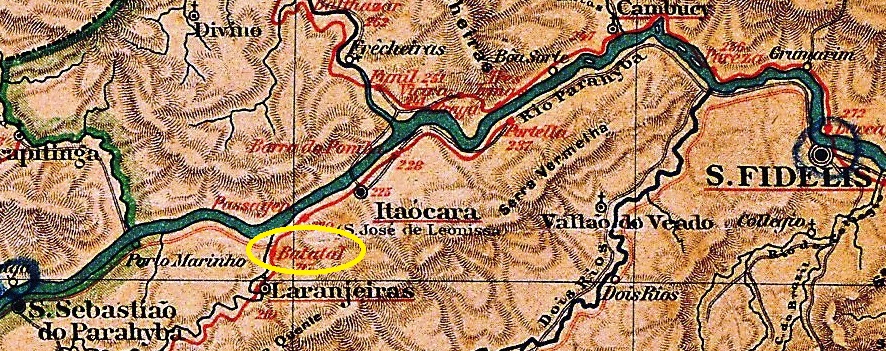
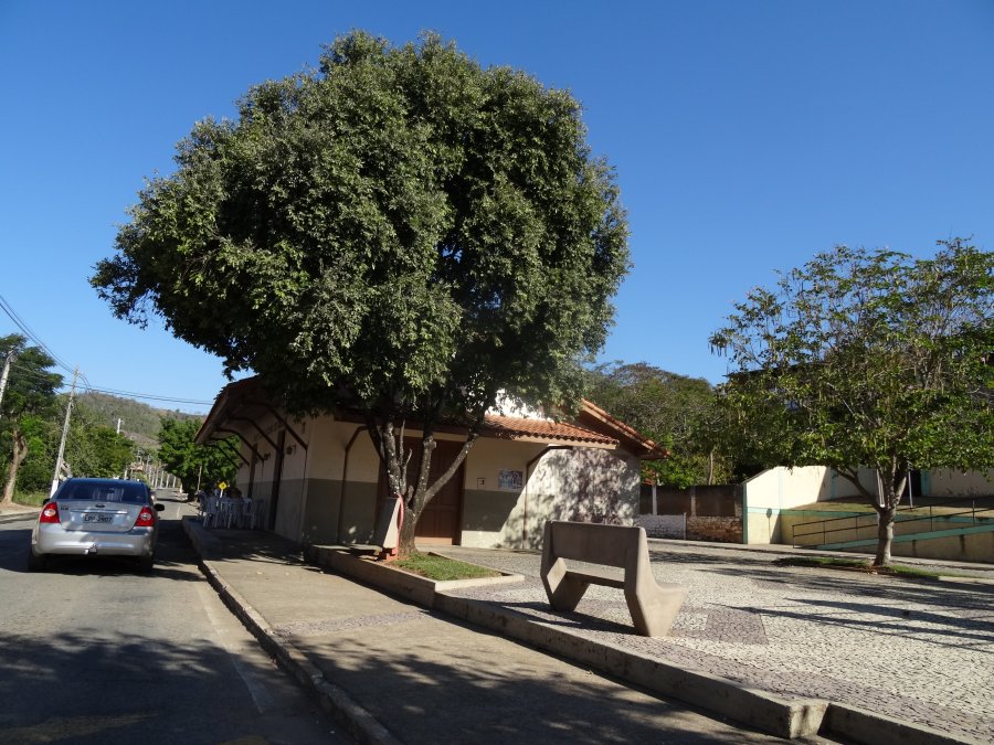
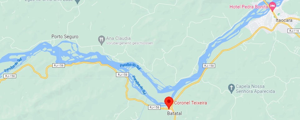
The Batatal (Potato Field) station was inaugurated in 1882 by the E.F. do Cantagallo (Cantagallo Branch) company and was located on the south bank of the Paraiba do Sul River in the Município of S. Fidélis, 240 km northeast of the capital Rio de Janeiro. The railway line changed to the E.F. Macahe e Campos in 1888 and belonged to the E.F. Leopoldina from 1890 until its closure in 1967. Since October 1890, the station has been in the Município of Itaocara, after which its name changed twice: in 1891 to Guapemerim and around 1960 to Coronel Teixeira. Today, the station building has been renovated again, but the rails are gone (estacoesferroviarias.com.br).
Ca. 2016 (Photo: Fernando Marietan, in estacoesferroviarias.com.br)
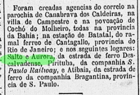
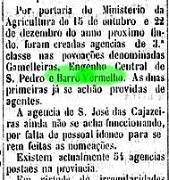
A railway station post office existed from August 1889, as reported by the capital’s press:
Gazeta de Noticias, 05/08/1889
The oldest cancel from this station so far is BRJ-0152a (Coll. Fuad Ferreira Fo.): a double circle with the inscriptions BATATAL above and (EST.) below. The only specimen found is dated 1891 in the centre.
Google Maps
Textaktualisierung am 29. März 2023
Der Bahnhof Batatal (Kartoffelfeld) wurde 1882 durch die Gesellschaft E.F. do Cantagallo (Cantagallo-Abzweigung) eingeweiht und lag am Südufer des Flusses Paraiba do Sul im Município von S. Fidélis, 240 km nordöstlich der Hauptstadt Rio de Janeiro entfernt. Die Bahnlinie wechselte 1888 zur E.F. Macahe e Campos und gehörte von 1890 bis zur Stilllegung 1967 zur E.F. Leopoldina. Seit Oktober 1890 liegt der Bahnhof im Município von Itaocara, danach wechselte sein Name zweimal: 1891 zu Guapemerim und ca. 1960 zu Coronel Teixeira. Heute ist das Bahnhofsgebäude wieder renoviert, aber die Schienen sind weg (estacoesferroviarias.com.br).
Ca. 2016 (Foto: Fernando Marietan, in estacoesferroviarias.com.br)
Einen Bahnhofspostamt gab es seit August 1889, wie die Hauptstadtpresse berichtete:
Gazeta de Noticias, 05.08.1889
Der bisher älteste Poststempel dieses Bahnhofs ist BRJ-0152a (Samml. Fuad Ferreira Fo.): ein Doppelkreis mit den Inschriften BATATAL oben und (EST.) unten. Das einzige gefundene Exemplar trägt in der Mitte die Jahreszahl 1891.
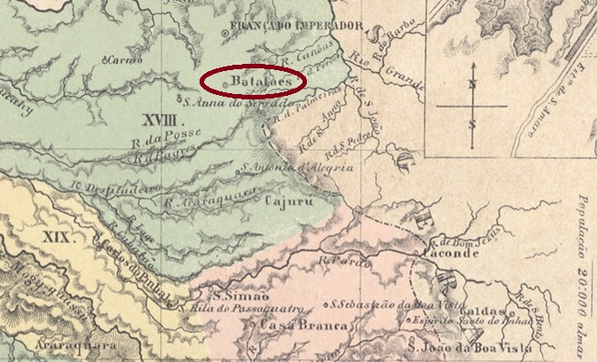
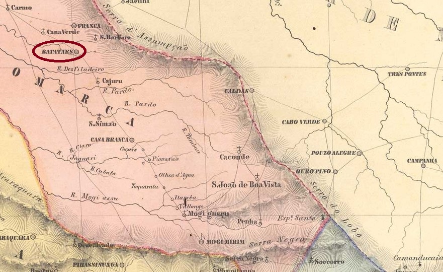
The Freguesia of Senhor Bom Jesus de Batataes was founded in March 1814, located on the Ribeirão (stream) dos Batatais around the Vila of Mogy-Mirim, 350 km north of the later provincial capital of São Paulo. In October 1821, the village changed to Vila Franca, was itself declared a vila in March 1839 and a town in April 1875.
Nova Monteiro, in Administrações e Agencias Postaes do Brasil Imperio (Brasil Filatelico/RJ, 1934-5; Reprint SPP 1994-1999), gives two dates for the birth of the local post office: first in October 1839, then again in December 1847. The second date is also given in the Directory of Imperial Post Offices (Tabella das Agencias do Correio do Imperio, Rio de Janeiro, 1885).
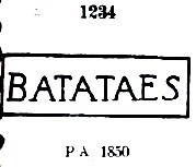
The first postmark is BSP-0130a, used from about 1843 until at least 1850 and already known by Paulo Ayres in Catálogo de Carimbos Brasil-Império, (S. Paulo, 1937, 1942) under No. 1234:
BSP-0130a (P.A. 1234) 1843ff-1850ff
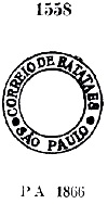
It was followed by BSP-0130b, which also exists in blue, was in use between c. 1866 and 1870 and was also introduced by P. Ayres (op. cit.) – this time with no. 1558:
BSP-0130b (P.A. 1558) 1866ff-1870
Next came BSP-0130c (ill. Mário Celso Orsi Jr.): a double circle with the inscription BATATAES at the top. A specimen seen, dated 1884 in the centre. The French type BSP-0130d (fig. from the internet) has the inscription BATATAES at the top and the typical star between brackets at the bottom, plus inner dates from 1886 to 1909.
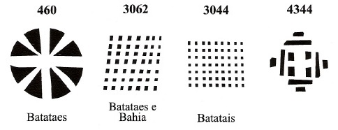
From this locality also come four mute cancellations registered by James Dingler and Klerman W. Lopes in Mute Cancellations of the Brazil Empire / Carimbos Mudos do Brasil Império (Brazil Philatelic Association, Rio de Janeiro, 2000) as follows:
BPA 460 (P.A. 65, 1876-1884, also in blue) – 3062 – 3044 – 4344 (P.A. 547, 1866ff)
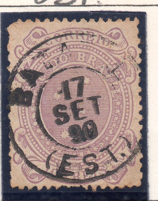
Finally, we have a puzzling postmark from Batataes station (image from the internet). It is dated 1890, but so far it has not been possible to find out when a station post office was created, nor when it started operating.
1890 (EB)
Villiers de l’Ile Adam: Carta (…) da Provincia de São Paulo, 1847
Die Freguesia von Senhor Bom Jesus de Batataes wurde im März 1814 gegründet und lag am Ribeirão (Bach) dos Batatais im Gebiet der Vila von Mogy-Mirim, 350 km nördlich der späteren Provinzhauptstadt São Paulo entfernt. Im Oktober 1821 wechselte der Ort zur Vila Franca, wurde selbst zur Vila im März 1839 und zur Stadt im April 1875 erklärt.
Nova Monteiro gibt in Administrações e Agencias Postaes do Brasil Imperio (Brasil Filatelico/RJ, 1934-5; Reprint SPP 1994-1999) gleich zwei Termine für die Entstehung des örtlichen Postamts: erstmals im Oktober 1839, dann wieder im Dezember 1847. Der zweite Termin wird auch im Verzeichnis der kaiserlichen Postämter (Tabella das Agencias do Correio do Imperio, Rio de Janeiro, 1885) genannt.
Der erste Poststempel ist BSP-0130a, der ab ca. 1843 bis mindestens 1850 verwendet wurde und bereits durch Paulo Ayres in Catálogo de Carimbos Brasil-Império, (S. Paulo, 1937, 1942) unter Nr. 1234 bekannt ist:
BSP-0130a (P.A. 1234) 1843ff-1850ff
Ihm folgte BSP-0130b , den es auch in Blau gibt, zwischen ca. 1866 und 1870 im Gebrauch war und ebenfalls durch P. Ayres (op. Cit.) – diesmal mit Nr. 1558 – vorgestellt wurde:
BSP-0130b (P.A. 1558) 1866ff-1870
Danach kam BSP-0130c (Abb. Mário Celso Orsi Jr.): ein Doppelkreis mit der Inschrift BATATAES oben. Ein Exemplar gesehen, datiert 1884 in der Mitte. Der französische Typ BSP-0130d (Abb. aus dem Internet) hat oben die Inschrift BATATAES und unten den typischen Stern zwischen Klammern, dazu innere Daten von 1886 bis 1909.
Aus diesem Ort kommen auch vier stumme Abstempelungen, die von James Dingler und Klerman W. Lopes in Mute Cancellations of the Brazil Empire / Carimbos Mudos do Brasil Império, (Brazil Philatelic Association, Rio de Janeiro, 2000) wie folgt registriert wurden:
Schließlich haben wir noch einen rätselhaften Poststempel aus dem Bahnhof Batataes (Abb. aus dem Internet). Er ist 1890 datiert, aber bisher konnte nicht ermittelt werden, weder wann über ein Bahnhofspostamt vor Ort entschieden wurde, noch wann dieses seinen Betrieb aufgenommen hat.
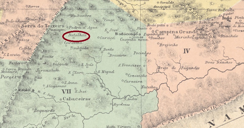
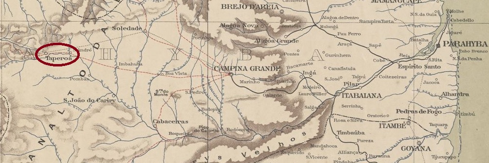
The Freguesia of N. Sra. dos Milagres do Batalhão was founded in October 1873 and was located on the south bank of the river Taperoá in the Município of S. João do Cariri, 270 km west of the provincial capital Parahyba do Norte (today: João Pessoa). The village was declared a vila in October 1886 and was called Taperoá from November 1905. Although the old place name Batalhão returned in December 1943, the Município has been called Taperoá again since January 1949.
As Reinhold Koester writes in Carimbologia III, there had been a post office there since March 1888. So far, no imperial postmark from Batalhão has been seen.
Serviço Geológico e Mineralógico do Brasil, 1910
Anderer Name: Taperoá (1905-1943, 1949)
Die Freguesia von N. Sra. dos Milagres do Batalhão wurde im Oktober 1873 gegründet und lag am Südufer des Flusses Taperoá im Município von S. João do Cariri, 270 km westlich der Provinzhauptstadt Parahyba do Norte (heute: João Pessoa) entfernt. Der Ort wurde im Oktober 1886 zur Vila erklärt, die ab November 1905 Taperoá hieß. Zwar kam der alte Ortsname Batalhão im Dezember 1943 zurück, aber seit Januar 1949 heißt der Município wieder Taperoá.
Wie Reinhold Koester in Carimbologia III schreibt, gab es dort ein Postamt seit März 1888. Bisher wurde kein kaiserlicher Poststempel aus Batalhão gesehen.
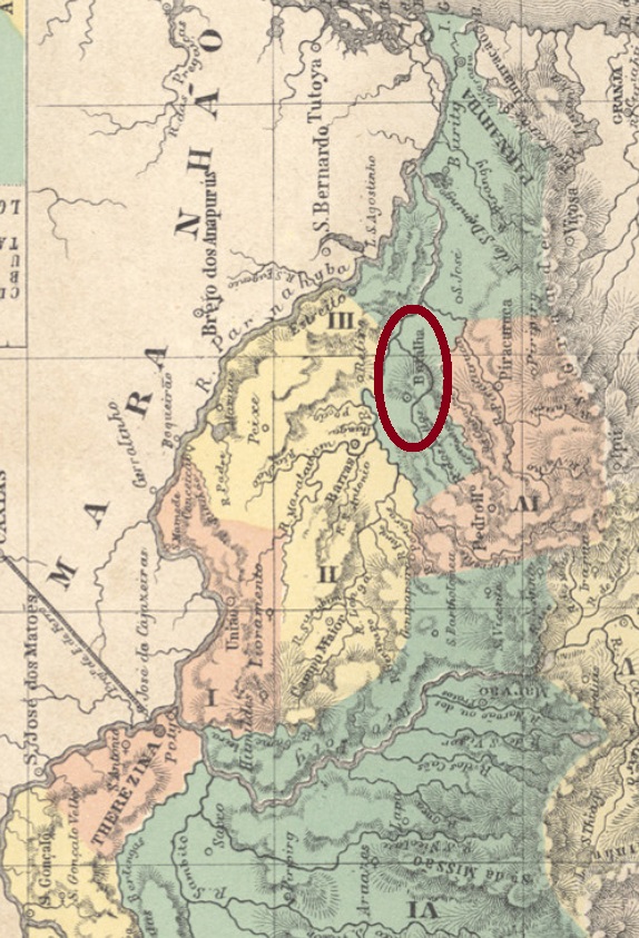
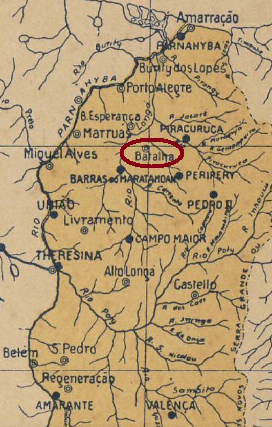
This second village in the province of Piauí in honour of Gonçalo (Gundisalvus) of Amarante – who was not actually a saint – became a district of Piracuruca in August 1853 and was located about 160 km northeast of the then newly created capital Teresina. Most historians assert that the name Batalha (= Battle) came from the long wars between Indians and Portuguese occupiers, but a reference to the Portuguese city of Batalha would also be plausible.
The locality became the villa of Batalha in December 1855. In June 1899, the municipality was renamed Campos Salles, in honour of the then Brazilian President Manuel Ferraz de Campos Salles (1841-1913). The connection to the unpopular president from São Paulo did not last long, and the name Batalha returned for good in June 1911.
Three creation dates for the local post office were found, apparently a sure hint that it was closed in between. Reinhold Koester (Carimbologia III) states that 22 March 1856, a year confirmed by the annual report of the General Postal Directory (Directoria Geral dos Correios) for 1859. Nova Monteiro, on the other hand, writes in Administrações e Agencias Postaes do Brasil Imperio (Brasil Filatelico/RJ, 1934-5; Reprint SPP 1994-1999) the exact date March 22, 1865. But there could be a number-turner in play, as this date is very similar to the previous one. Finally, 1882 is mentioned as the founding year by R. Koester.
The earliest postmark of the imperial period was found under the place name with the saint: SPI-0200a (Coll. Jorge L. Pedreira) consists of a double circle with the inscription S.G. DA BATALHA at the top. The only known specimen has a date from 1881 in the centre. And if the agency was in operation in 1881, an opening date from 1882 is unlikely. Later came BPI-0035a (Coll. Luis C. Fritzen): a double circle with the inscriptions BATALHA above and (PIAUHY) below. Again, only specimen found, dated 1897 in the centre.
Arthur D. Ribeiro: Estado do Piauhy, 1924
Textaktualisierung vom 27. März 2023
Anderer Name: Campos Salles (1899)
Siehe auch S. Gonçalo da Batalha (SPI-0200)
Diese zweite Ortschaft der Provinz Piauí zu Ehren von Gonçalo (Gundisalvus) von Amarante – der eigentlich noch kein Heiliger ist – wurde im August 1853 ein Distrikt von Piracuruca und lag ca. 160 km nordöstlich der damals frisch gekürten Hauptstadt Teresina. Die meisten Historiker meinen, der Name Batalha (= Schlacht) käme von den langen Kriegen zwischen Indianern und portugiesischen Besatzern, aber eine Anlehnung an die portugiesische Stadt Batalha wäre auch denkbar.
Aus dem Ort wurde im Dezember 1855 die Villa von Batalha. Im Juni 1899 wurde der Município zu Campos Salles umbenannt, zu Ehren vom damaligen brasilianischen Präsidenten Manuel Ferraz de Campos Salles (1841-1913). Der neue Ortsname fand offenbar kein Gefallen. Die Verbindung zum unbeliebten Präsidenten aus São Paulo währte nicht lange, und der Name Batalha kehrte im Juni 1911 definitiv zurück.
Es wurden drei Gründungsdaten fürs örtliche Postamt gefunden, im Prinzip ein sicheres Indiz dafür, dass es zwischendurch geschlossen wurde. Reinhold Koester (Carimbologia III) gibt hierfür den 22. März 1856 an, ein Jahr, dass durch den Jahresbericht der Allgemeinen Postdirektion (Directoria Geral dos Correios) für 1859 bestätigt wird. Nova Monteiro dagegen schreibt in Administrações e Agencias Postaes do Brasil Imperio (Brasil Filatelico/RJ, 1934-5; Reprint SPP 1994-1999) das genaue Gründungsdatum 22. März 1865. Da könnte aber ein Zahlendreher ins Spiel sein, da dieses Datum sehr ähnlich wie das frühere ist. Schließlich wird aus 1882 als Gründungsjahr durch R. Koester erwähnt.
Der früheste Poststempel der Kaiserzeit wurde unter dem Ortsnamen mit dem Heiligen gefunden: SPI-0200a (Samml. Jorge L. Pedreira) besteht aus einem Doppelkreis mit der Inschrift S.G. DA BATALHA oben. Das einzig bekannte Exemplar hat ein Datum aus 1881 in der Mitte. Und wenn die Agentur 1881 in Betrieb war, ist ein Eröffnungsdatum aus 1882 unwahrscheinlich. Später kam BPI-0035a (Samml. Luis C. Fritzen): ein Doppelkreis mit den Inschriften BATALHA oben und (PIAUHY) unten. Auch hier nur Exemplar gefunden, datiert 1897 in der Mitte.
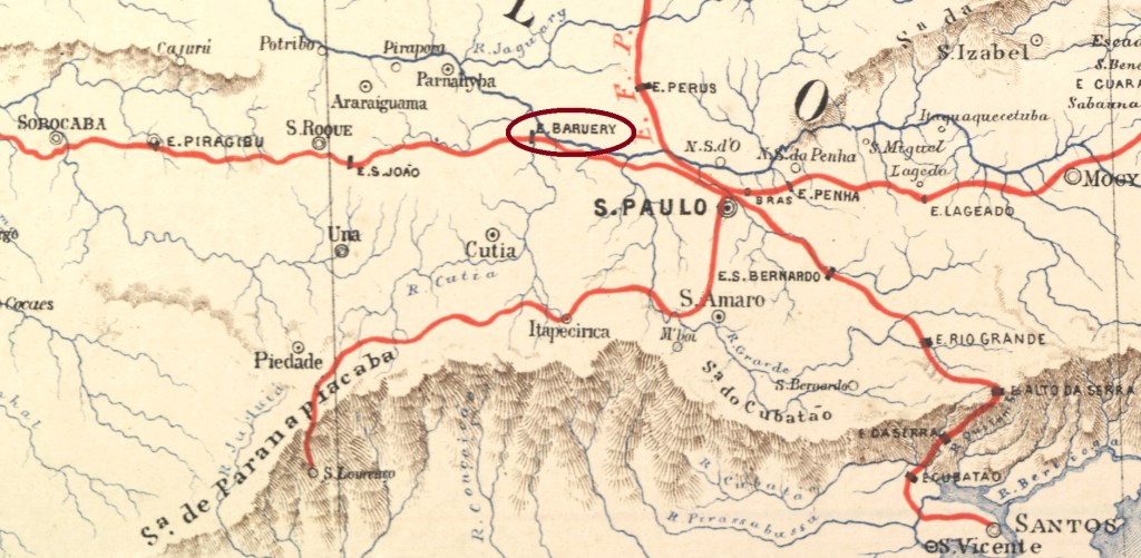
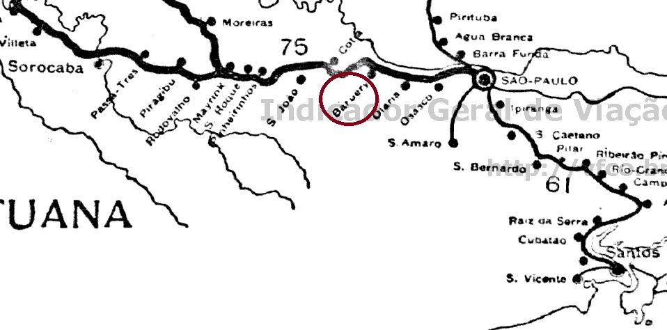
Baruery station was inaugurated in July 1875 by the E.F. Sorocabana railway company (Main Line), located close to where the Barueri-Mirim river flows into the Tietê, 30 km west of the provincial capital São Paulo. The railway line changed ownership several times: in 1892 to Cia. União Sorocabana e Ytuana, in 1907 to Sorocabana Railway, in 1919 back to E.F. Sorocabana, in 1971 to FEPASA, in 1994 to CPTM, and since 2022 it belongs to ViaMobilidade.
The village, which was supposedly a freguesia of the Vila of Parnahyba since 1809, grew rapidly after the railway connection and became a district in December 1918 and an independent município 30 years later.
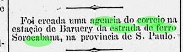
A railway station post office had existed since June 1887, as reported by the Rio press:
Diario de Noticias/RJ, 08.06.1887
The imperial postmark is BSP-0125a (image from the internet): a double circle with the inscription BARUERY at the top. The only specimen seen so far is red and was used on a D. Pedro issue of 1876.
E.F. Sorocabana e Ytuana, 1898
Der Bahnhof Baruery wurde im Juli 1875 durch die Bahngesellschaft E.F. Sorocabana (Hauptlinie) eingeweiht und lag nah an der Mündung des Flusses Barueri-Mirim in den Tietê, 30 km westlich der Provinzhauptstadt São Paulo. Die Bahnlinie wechselte mehrmals den Besitz: 1892 zur Cia. União Sorocabana e Ytuana, 1907 zur Sorocabana Railway, 1919 zurück zu E.F. Sorocabana, 1971 zur FEPASA, 1994 zur CPTM, und seit 2022 gehört sie zur ViaMobilidade.
Der Ort, der angeblich seit 1809 eine Freguesia der Vila von Parnahyba war, wuchs nach der Bahnverbindung rasch und wurde im Dezember 1918 zum Distrikt und 30 Jahre später zum eigenständigen Município.
Ein Bahnhofspost am gab es seit Juni 1887, wie die Presse aus Rio berichtete:
Diario de Noticias/RJ, 08.06.1887
Der kaiserliche Poststempel ist BSP-0125a (Abbildung aus dem Internet): ein Doppelkreis mit der Inschrift BARUERY oben. Das bisher einzig gesichtete Exemplar ist rot und wurde auf einer D. Pedro-Ausgabe von 1876 verwendet.
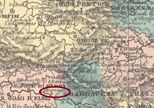
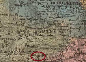
Around 1720, the chapel of Sant’Anna do Barroso was built, belonging to the vila of S. José d’El-Rei and located on the east bank of the Rio das Mortes, 150 km southwest of the future provincial capital Ouro Preto. In 1791, the place became an arraial – now belonging to the vila of Barbacena – and in December 1874, it became afFreguesia. Around 1910, Barroso returned as a district to the município of Tiradentes (ex- S. José d’El-Rei) and in December 1938 changed to the newly created município of Dores de Campos. Barroso has been an independent município since December 1953.
Two dates of origin for the local post office have been found. First in 1871, as it appears from the Directory of Imperial Post Offices (Tabella das Agencias do Correio do Imperio, Rio de Janeiro, 1885). Then in November 1878, as can be read in the postal report (Relatorio Postal) for 1887. Paula Sobrinho writes in História Postal de Minas Gerais (Belo Horizonte, 1997) that this agency was located at the railway station, which would only be true from the inauguration of the station by the Rede Mineira de Viação in September 1880.
Only one postmark from Barroso has been seen so far, which is probably not the very first one. BMG-0625b (ill. from the internet) is a double circle – its inner circle is often not, or hardly visible – with the broad inscription BARROSO. The dates inside go from 1887 to 1900.
Villiers de l’Ile Adam: Carta (…) da Provincia de Minas Geraes, 1849
Um 1720 wurde die Kapelle von Sant’Anna do Barroso errichtet, sie gehörte der Vila von S. José d’El-Rei und lag am Ostufer des Rio das Mortes, 150 km südwestlich der künftigen Provinzhauptstadt Ouro Preto. 1791 wurde der Ort zum Arraial – nun der Vila von Barbacena gehörend – und im Dezember 1874 zu einer Freguesia. Um 1910 kehrte Barroso als Distrikt zum Município von Tiradentes (ex- S. José d’El-Rei) zurück und wechselte im Dezember 1938 zum neu gegründeten Município von Dores de Campos. Seit Dezember 1953 ist Barroso ein eigenständiger Município.
Es wurden zwei Entstehungstermine fürs örtliche Postamt gefunden. Erstmals 1871, wie aus dem Verzeichnis der kaiserlichen Postämter (Tabella das Agencias do Correio do Imperio, Rio de Janeiro, 1885) hervorgeht. Dann im November 1878, wie man im Postbericht (Relatorio Postal) für 1887 lesen kann. Paula Sobrinho schreibt in História Postal de Minas Gerais (Belo Horizonte, 1997), dass diese Agentur am Bahnhof lag, was erst ab der Bahnhofseinweihung durch die Rede Mineira de Viação im September 1880 zutreffend wäre.
Aus Barroso wurde bisher nur ein Poststempel gesichtet, der wohl nicht der Allererste ist. BMG-0625b (Abb. aus dem Internet) ist ein Doppelkreis – wobei der innere Kreis auffallend oft nicht oder kaum sichtbar ist – mit der breit angelegten Inschrift BARROSO. Die Daten in Inneren gehen von 1887 bis 1900.
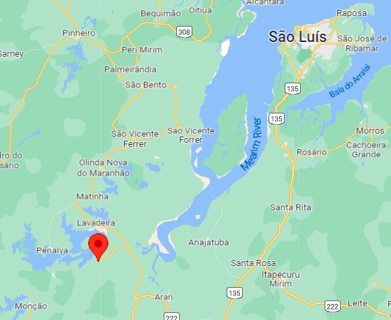
In the imperial province of Maranhão, there were several villages called Barro Vermelho (Red Mud). This one came into being around 1877 with the construction of the chapel of S. Benedito near the Vila of Monção close to the west bank of the river Pindaré, about 200 km southwest of the capital São Luís. Around 1893, the place went as a district to the Município of Penalva and became a vila in July 1925, which since November 1948 has been called Cajari, after a lake in the area.
The postal report (Relatorio Postal) for 1887 states that there was a post office there since October 1885. This is a misprint, because the regional press reported the date of establishment of the postal agency as exactly one year later:
Diario do Maranhão, 03.05.1887
So far, no imperial postmark from Barro Vermelho has been seen.
Google Maps
In der kaiserlichen Provinz Maranhão gab es mehrere Ortschaften, die Barro Vermelho (Roter Schlamm) hießen. Diese entstand um 1877 mit der Errichtung der Kapelle von S. Benedito bei der Vila von Monção nah am Westufer des Flusses Pindaré, ca. 200 km südwestlich der Hauptstadt São Luís. Um 1893 ging der Ort als Distrikt zum Município von Penalva und wurde im Juli 1925 eine Vila, die seit November 1948 Cajari heißt, nach einem See der Gegend.
Im Postbericht (Relatorio Postal) für 1887 heißt es, es gab dort ein Postamt seit Oktober 1885. Das ist ein Druckfehler, denn die Regionalpresse meldete als Entstehungstermin der Postagentur genau ein Jahr später:
Diario do Maranhão, 03.05.1887
Bisher war kein kaiserlicher Poststempel aus Barro Vermelho zu sehen.
Villiers de l’Ile Adam: Carta (…) das Provincias de Pernambuco, Alagoas e Sergipe, 1848
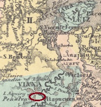
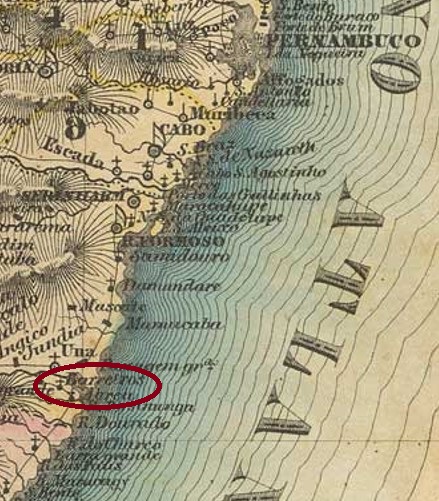
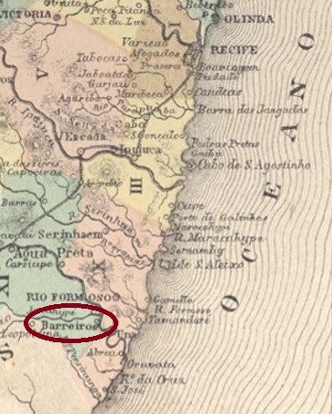
The chapel of S. Miguel dos Barreiros was built around 1720 and was located at the Vila of Serinhaem on the south bank of the Una River, over 100 km south of the provincial capital Recife. In 1786, the place became a freguesia, now belonging to the Vila of Rio Formoso. In May 1853, it was promoted to a vila in its own município, and since June 1892, Barreiros has been a town.
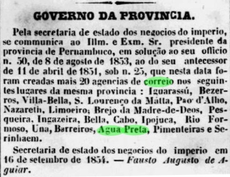
Nova Monteiro writes in Administrações e Agencias Postaes do Brasil Imperio (Brasil Filatelico/RJ, 1934-5; Reprint SPP 1994-1999) that there had been a post office there since September 1854. This is confirmed by the Recife press:
Diario de Pernambuco/07.10.1854
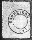
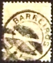
Koester, on the other hand, mentions January 1855 in Carimbologia III, which could, however, be the time when the agency started operations. The only postmark in the Empire so far is the French type BPE-0070b, which was used between about 1876 and at least 1894 and is already known by R. Koester (op. cit.):
BPE-0070b (RK)
From Barreiros a mute cancel (Coll. Claudio Coelho) was also found:
1885ff (CC)Atlas do Imperio do Brasil, 1868
Die Kapelle von S. Miguel dos Barreiros wurde ca. 1720 errichtet und lag bei der Vila von Serinhaem am Südufer des Una-Flusses, gut 100 km südlich der Provinzhauptstadt Recife. 1786 wurde der Ort zu einer Freguesia, nun der Vila von Rio Formoso gehörend. Im Mai 1853 erfolgte der Aufstieg zur Vila im eigenen Município, und seit Juni 1892 ist Barreiros eine Stadt.
Nova Monteiro schreibt in Administrações e Agencias Postaes do Brasil Imperio (Brasil Filatelico/RJ, 1934-5; Reprint SPP 1994-1999), dass es dort seit September 1854 ein Postamt gab. Dieses wird durch die Presse aus Recife bestätigt:
Diario de Pernambuco/07.10.1854
Koester nennt in Carimbologia III dagegen den Januar 1855, was eher der Zeitpunkt der Inbetriebnahme der Agentur sein könnte. Der bisher einzige Poststempel im Kaiserreich ist der französische Typus BPE-0070b, der zwischen ca. 1876 und mindestens 1894 verwendet wurde und durch R. Koester (op. cit.) bereits bekannt ist:
BPE-0070b (RK)
Aus Barreiros wurde auch eine stumme Entwertung (Samml. Claudio Coelho) gefunden:
São José do Barreiro (also spelled dos Barreiros) was a freguesia in the municipality of Areias, located at the foothills of the Serra da Bocaína, more than 260 km northeast of the provincial capital São Paulo. The village rose to a villa in March 1859 and to a town in March 1885. Between 1938 and 1953, the municipality was simply called Barreiro, then the old, full name returned.
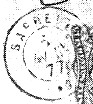
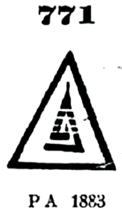
According to Nova Monteiro (Administrações e Agencias Postaes do Brasil Imperio, in Brasil Filatelico/RJ, 1934-5; Reprint SPP 1994-1999) the local post office was established in December 1834. The first two cancels of the agency bore the name BARREIRO.
The first of these is BSP-0110a, which was used at least between 1843 and 1850, also occurs in blue and brown and is already known by P. Ayes in Catálogo de Carimbos Brasil-Império (S. Paulo, 1937, 1942) under No. 1233:
BSP-0110a (P.A. 1233) 1843-1850ff
It was followed by the French type BSP-0110b, which also occurs in blue and green and was in use at least between 1870 and 1877. Here is the illustration by R. Koester in Carimbologia III:
BSP-0110b (RK) 1870-1877
Two mute cancels from there have also survived. James Dingler and Klerman W. Lopes in Mute Cancellations of the Brazil Empire / Carimbos Mudos do Brasil Império (Brazil Philatelic Association, Rio de Janeiro, 2000) have registered the first of these as no. 211, which also exists in blue and corresponds to no. 471 in P. Ayres (op. cit.):
BPA 211 (P.A. 471b) 1866ff-1877
The philatelist Mário Celso Orsi Jr. wrote that no. 4152 of Dingler/Lopes (op. cit.) also comes from Barreiro and appears in blue:
BPA 4152 (P.A. 771b) 1879-1886
For later postmarks with inscription São José do Barreiro see SSP-1585.
Villiers de l’Ile Adam: Carta (…) da Provincia de São Paulo, 1847
Siehe auch São José do Barreiro (SSP-1585)
São José do Barreiro (auch dos Barreiros geschrieben) war ab März 1842 eine Freguesia im Município von Areias, die am Ausläufer der Serra da Bocaína, über 260 km nordöstlich der Provinzhauptstadt São Paulo entfernt lag. Der Ort stieg im März 1859 zur Villa und im März 1885 zur Stadt auf. Zwischen 1938 und 1953 hieß der Município einfach Barreiro, dann kehrte der alte, vollständige Name zurück.
Laut Nova Monteiro (Administrações e Agencias Postaes do Brasil Imperio, in Brasil Filatelico/RJ, 1934-5; Reprint SPP 1994-1999) entstand das örtliche Postamt bereits im Dezember 1834. Die ersten zwei Stempel der Agentur trugen die Bezeichnung BARREIRO. Der erste davon ist BSP-0110a, der zumindest zwischen 1843 und 1850 verwendet wurde, auch in blau und braun vorkommt und bereits durch P. Ayes in Catálogo de Carimbos Brasil-Império, (S. Paulo, 1937, 1942) unter Nr. 1233 bekannt ist:
BSP-0110a (P.A. 1233) 1843-1850ff
Ihm folgte der französischer Typus BSP-0110b, der ebenfalls in blau und grün vorkommt und zumindest zwischen 1870 und 1877 in Gebrauch war. Hier die Abbildung von R. Koester in Carimbologia III:
BSP-0110b (RK) 1870-1877
Zwei stumme Abstempelungen von dort sind auch überliefert. James Dingler und Klerman W. Lopes haben in Mute Cancellations of the Brazil Empire / Carimbos Mudos do Brasil Império, (Brazil Philatelic Association, Rio de Janeiro, 2000) die erste davon unter Nr. 211 registriert, die auch in Blau existiert und Nr. 471 in P. Ayres (op. cit.) entspricht :
BPA 211 (P.A. 471b) 1866ff-1877
Der Philatelist Mário Celso Orsi Jr. schrieb, auch Nr. 4152 von Dingler/Lopes (op. cit.) käme aus Barreiro und erscheine in Blau:
BPA 4152 (P.A. 771b) 1879-1886
Für spätere Stempel (mit Inschrift São José do Barreiro, ab ca. 1879) siehe SSP-1585.
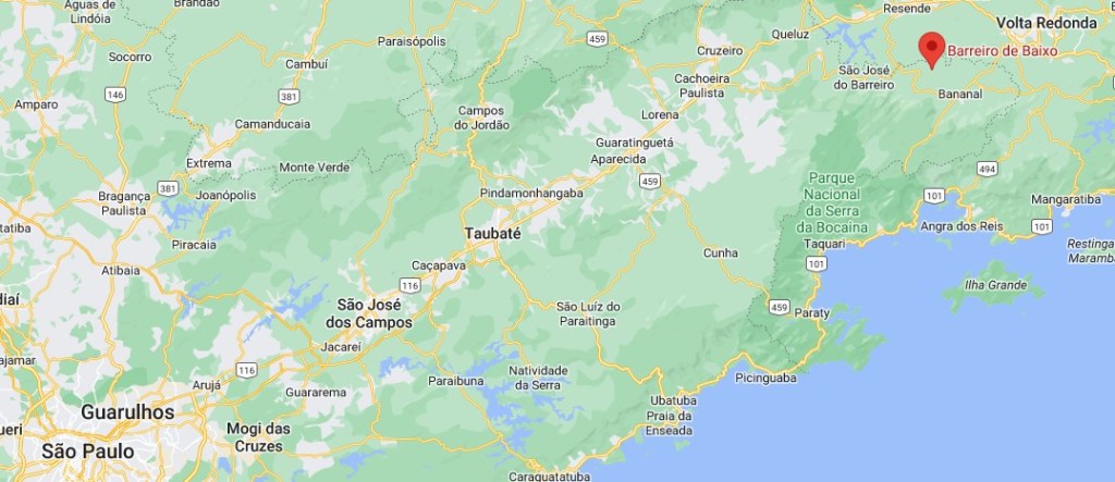
The chapel of Sto. Antonio do Barreiro de Baixo was built around 1850 in the Município of Bananal and was located on the Barreiro de Baixo River, 300 km northeast of the provincial capital of São Paulo. The village developed very slowly due to the decline of the coffee industry on the Paraíba do Sul valley and became a rural suburb in the Município of Arapeí in December 1991.
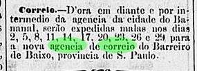
As R. Koester writes in Carimbologia III, there had been a post office there since January 1885, which started operating the following month, as reported by the Rio press:
Brazil/RJ, 13.02.1885
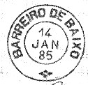
The imperial postmark is BSP-0115a, also known through R. Koester (op. cit.):
BSP-0115a (RK) 1885-1894Google Maps
Die Kapelle von Sto. Antonio do Barreiro de Baixo wurde ca. 1850 im Município von Bananal errichtet und lag am Fluss Barreiro de Baixo, 300 km nordöstlich der Provinzhauptstadt São Paulo entfernt. Der Ort entwickelte sich durch den Niedergang der Kaffeewirtschaft am Paraíba do Sul-Tal sehr langsam und wurde im Dezember 1991 zu einem ländlichen Vorort im Município von Arapeí.
Wie R. Koester in Carimbologia III schreibt, gab es dort ein Postamt seit Januar 1885, das im folgenden Monat seinen Betrieb aufnahm, wie die Presse aus Rio meldete:
Brazil/RJ, 13.02.1885
Der kaiserliche Poststempel ist BSP-0115a, der ebenfalls durch R. Koester (op.cit.) bekannt ist: