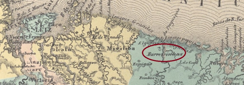
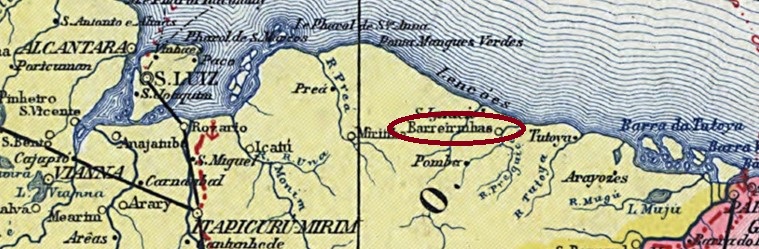
The Freguesia of N. Sra. da Conceição das Barreirinhas was created in June 1858 at the Vila of Tutoya and was located on the south bank of the Preguiças River, 250 km east of the provincial capital of São Luís do Maranhão. The place rose to the status of vila in June 1871 and town in January 1938.
As the postal report (Relatório Postal) for 1887 shows, there was a post office there since July 1873. Reinhold Koester shows a postmark and handwritten cancellation from there in Carimbologia III:
BMA-0040a (RK) 18871878ff (RK)Carta da Republica dos Estados Unidos do Brazil, 1892
Die Freguesia von N. Sra. da Conceição das Barreirinhas entstand im Juni 1858 bei der Vila von Tutoya und lag am Südufer des Flusses Preguiças, 250 km östlich der Provinzhauptstadt São Luís do Maranhão. Der Ort stieg im Juni 1871 zur Vila und im Januar 1938 zur Stadt auf.
Wie aus dem Postbericht (Relatório Postal) für 1887 hervorgeht, gab es dort ein Postamt seit Juli 1873. Reinhold Koester zeigt im Carimbologia III einen Poststempel und eine handschriftliche Entwertung von dort:
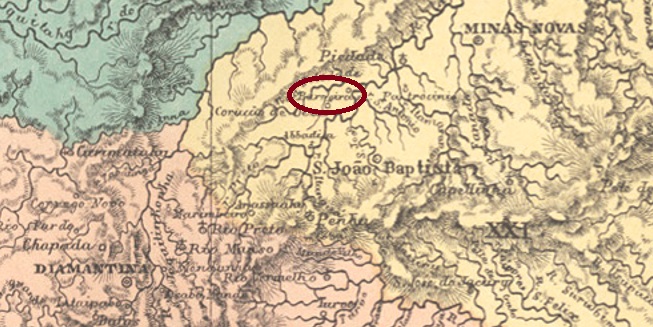
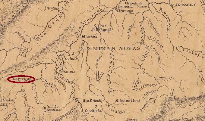
The old Arraial of Santissimo Coração de Jesus das Barreiras was located on the north bank of the Araçuaí River in the Município of Minas Novas, 500 km north of the provincial capital of Ouro Preto. In September 1862, the village became part of the newly founded Município of S. João Baptista de Minas Novas – which has been called Itamarandiba since 1923 – and became a freguesia in September 1870. In December 1943, the name Carbonita was given to the village, which became an independent Município 19 years later.
As Paula Sobrinho writes in História Postal de Minas Gerais (Belo Horizonte, 1997), there had been a post office there since October 1886. The agency closed in December 1896 and reopened in September the following year. So far, no imperial postmark from Barreiras has been seen.
Provincia de Minas Geraes, 1873
Anderer Name: Carbonita (1943)
Der alte Arraial von Santissimo Coração de Jesus das Barreiras lag am Nordufer des Flusses Araçuaí im Município von Minas Novas, 500 km nördlich der Provinzhauptstadt Ouro Preto. Im September 1862 ging die Ortschaft zum neu gegründeten Município von S. João Baptista de Minas Novas – der seit 1923 Itamarandiba heißt – und wurde im September 1870 zur Freguesia. Im Dezember 1943 wurde dem Ort der Name Carbonita verpasst, der 19 Jahre später zum eigenständiger Município wurde.
Wie Paula Sobrinho in História Postal de Minas Gerais (Belo Horizonte, 1997) schreibt, gab es dort ein Postamt seit Oktober 1886. Die Agentur wurde im Dezember 1896 geschlossen und eröffnete wieder im September des folgenden Jahres. Bisher war kein kaiserlicher Poststempel aus Barreiras zu sehen.
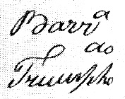
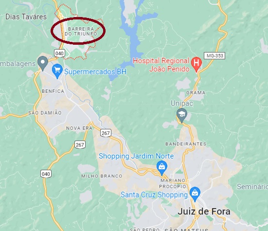
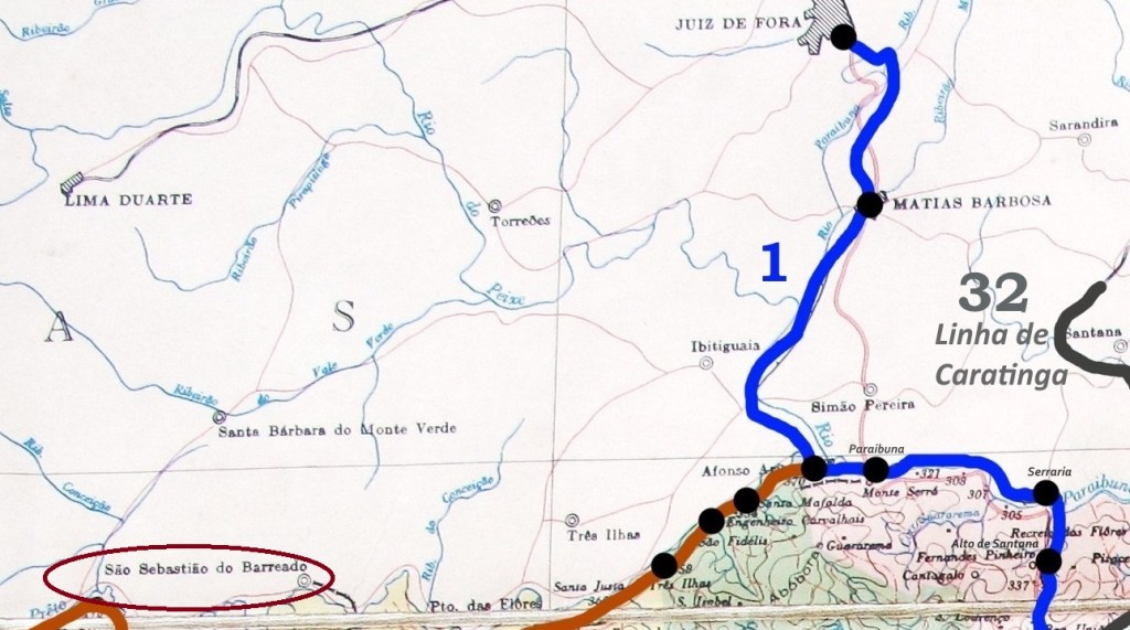
A barreira was a fiscal checkpoint where the transport of goods was asked to pay on the way. Barreira do Triumpho – named after a fazenda in the area – was located north of the town of Santo Antonio do Paraibuna (today Juiz de Fora) on the New Road (Estrada Nova) between Minas and Rio de Janeiro, on the east bank of the Paraibuna River, 200 km south of the provincial capital Ouro Preto. Today, Barreira do Triunfo is a suburb of Juiz de Fora.
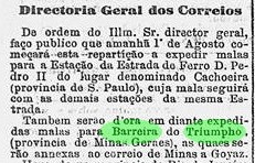
As Paula Sobrinho writes in História Postal de Minas Gerais (Belo Horizonte, 1997), the creation of a post office there was decreed in July 1875, and it began operating the following month, as can be seen from the Rio Press:
O Globo/RJ 31.07.1875
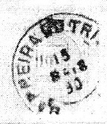
An early handwritten postal cancellation was presented by R. Koester in Carimbologia III, a sure indication that here too the postmark had not arrived on site in time:
1876ff (RK)
Next came BMG-0255a, also known through Koester (op. cit.):
BMG-0255a (RK) 1890Google Maps
Eine Barreira war eine Fiskus-Kontrollstelle, an der unterwegs der Warentransport zur Kasse gebeten wurde. Die Barreira do Triumpho – genannt nach einer Fazenda der Gegend – lag nördlich der Stadt Santo Antonio do Paraibuna (heute Juiz de Fora) an der Neuen Strasse (Estrada Nova) zwischen Minas und Rio de Janeiro, am Ostufer des Flusses Paraibuna, 200 km südlich der Provinzhauptstadt Ouro Preto entfernt. Heute ist Barreira do Triunfo ein Vorort von Juiz de Fora.
Wie Paula Sobrinho in História Postal de Minas Gerais (Belo Horizonte, 1997) schreibt, wurde im Juli 1875 über die Entstehung eines Postamts dort verfügt, das im folgenden Monat den Betrieb aufnahm, wie aus der Rio-Presse entnommen werden kann:
O Globo/RJ 31.07.1875
Eine frühe handschriftliche postalische Entwertung wurde durch R. Koester in Carimbologia III vorgestellt, ein sicheres Indiz dafür, dass auch hier der Poststempel nicht rechtzeitig vor Ort eingetroffen war:
1876ff (RK)
Danach kam BMG-0255a, der ebenfalls durch Koester (op. cit.) bekannt ist:
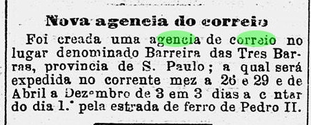
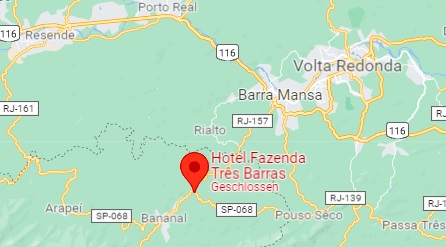
A barreira was a barrier on trunk roads where tax or toll was collected. The Barreira das Tres Barras, as R. Koester tells us in Carimbologia III, was located at the confluence of three streams (Turvo, Agua Comprida and Pirapetinga) with the Bananal River. Tres Barras was also the name of the fazenda 500 metres away, which today is a hotel. Bananal was also the name of the municipality responsible for this place, located 320 km northeast of the provincial capital São Paulo.
A post office at this barreira was established in March 1876, as reported by the Rio press:
O Globo/RJ, 25/03/1876
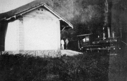
In October 1888, a station of the E.F. do Bananal railway company was inaugurated there. The railway line passed to the E.F. Central do Brasil in 1918 and remained in their possession (apart from a few months in 1931 with the E.F. Oeste de Minas) until it was closed in 1964. The station has long since been demolished (estacoesferroviarias.com.br).
ca. 1900 Photo Moitinho family (estacoesferroviarias.com.br)
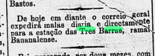
From May 1889, the Tres Barras station also received the mail bags for the town:
Diario de Noticias/RJ, 24.05.1889
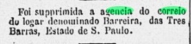
This made the old post office redundant, and it closed in December of that year:
Gazeta de Noticias/RJ, 03.12.1889
The first postmark was BSP-0105a, already presented as TSP-1440a (Col. Fuad Ferreira Fo.): a French type, with the inscription B. DAS TRES BARRAS at the top and the star between brackets at the bottom. Dates in the middle from 1877ff to 1885.
Google Maps
Siehe auch Tres Barras (TSP-1440)
Eine Barreira war eine Schrankstelle auf Fernstraßen, wo Steuer oder Maut eingetrieben wurde. Die Barreira das Tres Barras lag, wie uns R. Koester in Carimbologia III erzählt, an der Mündung von drei Bächen (Turvo, Agua Comprida und Pirapetinga) in den Bananal-Fluss. Tres Barras hieß auch die 500 Meter entfernte Fazenda, die heute als Hotel fungiert. Bananal hieß auch die zuständige Gemeinde für diesen Ort, 320 km nordöstlich von der Provinzhauptstadt São Paulo gelegen.
Ein Postamt an dieser Barreira entstand im März 1876, wie die Presse aus Rio berichtet:
O Globo/RJ, 25.03.1876
Im Oktober 1888 wurde dort ein Bahnhof der E.F. do Bananal Bahngesellschaft eingeweiht. Die Bahnlinie ging 1918 zur E.F. Central do Brasil über und blieb in deren Besitz (abgesehen von ein paar Monaten 1931 bei der E.F. Oeste de Minas) bis zur Stilllegung 1964. Der Bahnhof ist längst abgerissen worden (estacoesferroviarias.com.br).
ca. 1900 Foto Familie Moitinho (estacoesferroviarias.com.br)
Ab Mai 1889 erhielt der Bahnhof Tres Barras auch die Postsäcke für den Ort:
Diario de Noticias/RJ, 24.05.1889
Dadurch wurde das alte Postamt überflüssig und schloss im Dezember d. Js. zu:
Gazeta de Noticias/RJ, 03.12.1889
Der erste Poststempel war BSP-0105a, der bereits als TSP-1440a (Samml. Fuad Ferreira Fo.) vorgestellt wurde: ein französischer Typus, mit der Inschrift B. DAS TRES BARRAS oben und dem Stern zwischen Klammern unten. Daten in der Mitte von 1877ff bis 1885.
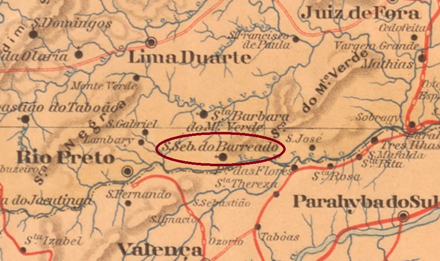
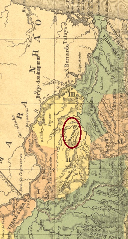
This locality was the freguesia of S. Sebastião do Barreado, which came into being in October 1884 in the município of Rio Preto and was located on the north bank of the Rio Preto, 290 km south of the provincial capital of Ouro Preto. Since December 1995, S. Sebastião do Barreado has been a district in the município of Sta. Bárbara do Monte Verde.
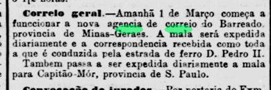
The imperial post office was created in January 1879, as Paula Sobrinho writes in História Postal de Minas Gerais (Belo Horizonte, 1997). The information is confirmed by the Postal Report (Relatorio Postal) for 1887. However, operations did not start until March, as announced in the Rio press:
Jornal do Commercio/RJ, 28/02/1879
In the early Republic, the agency closed twice, as Paula Sobrinho also tells us: in December 1896 and February 1899, to reopen in January 1898 and December 1912 respectively.
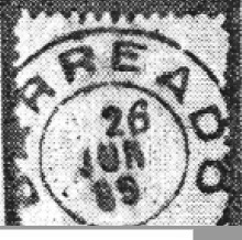
The only imperial postmark so far is BMG-0250b, as shown by R. Koester in Carimbologia III:
BMG-0250b (RK) 1889agenciaspostais.com.br
Diese Ortschaft war die Freguesia von S. Sebastião do Barreado, die im Oktober 1884 im Município von Rio Preto entstand und am Nordufer des Rio Preto lag, 290 km südlich der Provinzhauptstadt Ouro Preto. Seit Dezember 1995 ist S. Sebastião do Barreado ein Distrikt im Município von Sta. Bárbara do Monte Verde.
Das kaiserliche Postamt wurde im Januar 1879 ins Leben gerufen, wie Paula Sobrinho in História Postal de Minas Gerais (Belo Horizonte, 1997) schreibt. Die Angabe wird durch den Postbericht (Relatorio Postal) für 1887 bestätigt. Allerdings startete der Betrieb erst im März, wie in der Presse aus Rio angekündigt:
Jornal do Commercio/RJ, 28.02.1879
In der frühen Republik schloss die Agentur zweimal, wie uns Paula Sobrinho ebenfalls mitteilt: im Dezember 1896 und im Februar 1899, um im Januar 1898 bzw. im Dezember 1912 wieder zu öffnen.
Der bisher einzige kaiserliche Poststempel ist BMG-0250b und wurde durch R. Koester in Carimbologia III gezeigt:
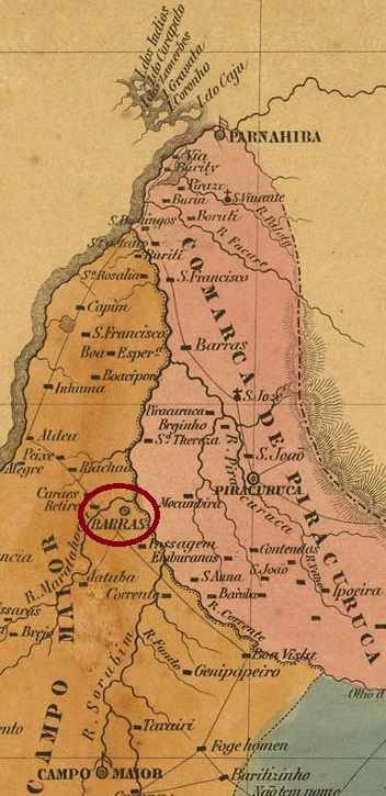
The freguesia of N. Sa. da Conceição das Barras was established as early as October 1823 and was located on the north bank of the Maratauã River, where six waterways come together, barely 130 km north of the later provincial capital of Teresina. The village was elevated to a district in the Município of Campo Maior in September 1836 and to a vila in September 1841. It has been the town of Barras since December 1889.
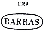
Two creation years for the local post office have been found. First in May 1856, as Nova Monteiro writes in Administrações e Agencias Postaes do Brasil Imperio (Brasil Filatelico/RJ, 1934-5; Reprint SPP 1994-1999). Then 1882, as listed in the Directory of Imperial Post Offices (Tabella das Agencias do Correio do Imperio, Rio de Janeiro, 1885). The earliest postmark is BPI-0030a, already presented by Paulo Ayres in Catálogo de Carimbos Brasil-Império (S. Paulo, 1937, 1942) under no. 1229:
BPI-0030a (P.A. 1229)
Later postmarks already bear the inscription VILLA DAS BARRAS (see VPI-0220).
Villiers de l’Ile Adam: Carta (…) da Provincia do Piauhy, 1850
Andere Namen: Barras de Maratahoan, Maratahoan
Siehe auch Villa das Barras (VPI-0220)
Die Freguesia von N. Sa. da Conceição das Barras entstand bereits im Oktober 1823 und lag am Nordufer des Maratauã-Flusses, wo sechs Wasserwege zusammenkommen, knapp 130 km nördlich der späteren Provinzhauptstadt Teresina entfernt. Der Ort wurde im September 1836 zum Distrikt im Município von Campo Maior und im September 1841 zur Vila erhoben. Seit Dezember 1889 ist er die Stadt von Barras.
Zwei Gründungsjahre fürs örtliche Postamt wurden gefunden. Erstmals im Mai 1856, wie Nova Monteiro in Administrações e Agencias Postaes do Brasil Imperio (Brasil Filatelico/RJ, 1934-5; Reprint SPP 1994-1999) schreibt. Dann 1882, wie im Verzeichnis der kaiserlichen Postämter (Tabella das Agencias do Correio do Imperio, Rio de Janeiro, 1885) aufgelistet. Der früheste Poststempel ist BPI-0030a, der bereits durch Paulo Ayres in Catálogo de Carimbos Brasil-Império (S. Paulo, 1937, 1942) unter Nr. 1229 vorgestellt wurde:
BPI-0030a (P.A. 1229)
Spätere Poststempel tragen schon die Inschrift VILLA DAS BARRAS (s. VPI-0220).
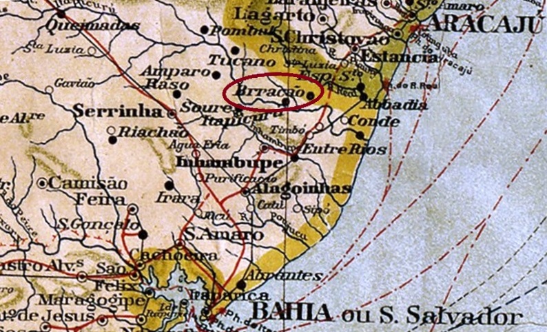
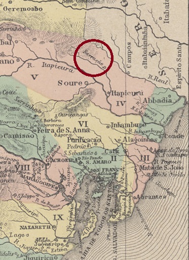
This locality was the former Freguesia of N. Sra. do Livramento do Brejo Grande (Our Lady of Liberation at the Great Swamp), located in the Município of Itapicuru close to the provincial border with Sergipe, 210 km north of the capital Salvador da Bahia. In July 1870, it became the Vila of Barracão, which has been the Município of Rio Real since June 1931.
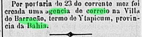
As Reinhold Koester writes in Carimbologia III, there was a post office there since July 1887, which is confirmed by the Rio press:
Novidades/RJ, 28.07.1887
So far, no imperial postmark from Barracão has been seen.
Atlas do Imperio do Brasil, 1868
Andere Namen: Brejo Grande, Rio Real (1931)
Diese Ortschaft war die frühere Freguesia von N. Sra. do Livramento do Brejo Grande (Unsere Liebe Frau der Befreiung am Großen Sumpf), die im Município von Itapicuru nah an der Provinzgrenze zu Sergipe lag, 210 km nördlich der Hauptstadt Salvador da Bahia entfernt. Im Juli 1870 wurde daraus die Vila von Barracão, die seit Juni 1931 der Município von Rio Real ist.
Wie Reinhold Koester in Carimbologia III schreibt, gab es dort ein Postamt seit Juli 1887. Das wird durch die Presse aus Rio bestätigt:
Novidades/RJ, 28.07.1887
Bisher war kein kaiserlicher Poststempel aus Barracão zu sehen.
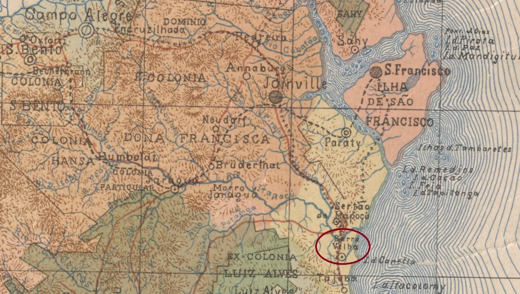
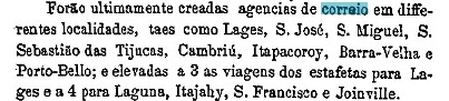
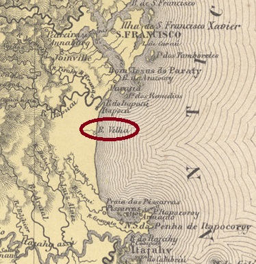
The Freguesia of São Pedro d’Alcantara da Barra Velha originally belonged to the Vila of S. Francisco and was located on the Atlantic Ocean, 130 km north of the provincial capital of Desterro (today: Florianópolis). In April 1876, it changed to the Vila of Paraty, which was renamed Araquary in December 1943. Since November 1961, Barra Velha has been an independent município.
According to the Imperial Post Office Directory (Tabella das Agencias do Correio do Imperio, Rio de Janeiro, 1885), there has been a post office there since 1875. This information is confirmed by the provincial president’s report for the following year:
Relatorio do Presidente da Provincia /SC 1876
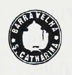
The only imperial postmark so far is BSC-0015b, which can be seen in Paulo Ayres’ Catálogo de Carimbos Brasil-Império, (S. Paulo, 1937, 1942) unfortunately without further data:
BSC-0015b (P.A. p. 145)Atlas do Imperio do Brasil 1868
Die Freguesia von São Pedro d’Alcantara da Barra Velha gehörte ursprünglich der Vila von S. Francisco und lag am Atlantik, 130 km nördlich der Provinzhauptstadt Desterro (heute: Florianópolis). Im April 1876 wechselte sie zur Vila von Paraty, die im Dezember 1943 zu Araquary umbenannt wurde. Seit November 1961 ist Barra Velha ein eigenständiger Município.
Wie aus demVerzeichnis der kaiserlichen Postämter /(Tabella das Agencias do Correio do Imperio, Rio de Janeiro, 1885) hervorgeht, gab es dort ein Postamt seit 1875. Die Angabe wird durch den Bericht des Provinzpräsidenten fürs folgende Jahr bestätigt:
Relatorio do Presidente da Provincia /SC 1876
Der bisher einzige kaiserliche Poststempel ist BSC-0015b, der im Paulo Ayres‘ Catálogo de Carimbos Brasil-Império, (S. Paulo, 1937, 1942) leider ohne weitere Daten zu sehen ist:
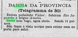
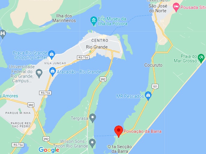
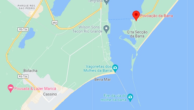
There has been a great deal of puzzlement about this post office. R. Koester (Carimbologia III) could not definitively find out whether this was a small settlement near S. José do Norte or the present town of Barra do Ribeiro. We believe that the first alternative is the correct one and are talking about the Povoação de N. Sra. da Boa Viagem da Barra do Rio Grande (Settlement of Our Lady of the Good Voyage at the mouth of the Rio Grande), a small sleepy village that is still a rural suburb of S. José do Norte, located 320 km south of the capital Porto Alegre.
As Nova Monteiro points out in Administrações e Agencias Postaes do Brasil Imperio (Brasil Filatelico/RJ, 1934-5; Reprint SPP 1994-1999), there had been a post office there since November 1867. At that time, what is now Barra do Ribeiro was not a settlement worth mentioning, while Barra do Rio Grande was eminently important for two reasons. First, the mouth of the canal to Lagoa dos Patos was a strategic defence point in a region that had experienced centuries of war. And secondly, this very mouth was a challenge for all ship captains, as the open sea access with a bottom of thin sand caused a constant change of navigation channel, causing countless ships to run aground over time.
This problem was recognised early on and can also explain why the settlement of Brazil’s southernmost province went relatively slowly. But a solution was a long time coming. It was not until about 1880 that an appointed team of engineers from England tackled the task, and it was not until 1919 that the two breakwaters protecting the entrance to the canal were completed.
Google Maps
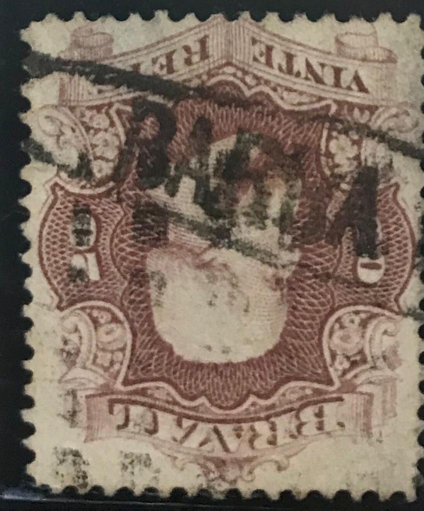
Imperial postmarks from Barra are also a long time coming. The example below (Coll. Klerman Lopes) was initially assumed to be BRS-0025a, but is more likely to belong to Barra de S. Matheus in Espirito Santo province (see BES-0035):
(KL) 1866ff
Since the Barra agency was not listed in the Directory of Imperial Post Offices (Tabella das Agencias do Correio do Imperio, Rio de Janeiro, 1885) and thereafter, we may assume that the works on the navigation canal made it redundant and it was closed around 1880. Or was it simply replaced in the 80s by a telegraph post that could report the respective navigation status more quickly:
A Federação, 09.01.1885
In July 1890 – i.e. in the early Republic – a Barra post office was established, but this is probably Barra do Ribeiro. The postmarks are double circles with inscriptions BARRA above and (S.P. DO SUL) below.
Google Maps
Textaktualisierung vom 10.03.2023
Über dieses Postamt wird sehr lange gerätselt. R. Koester (Carimbologia III) konnte nicht endgültig herausfinden, ob es sich hier um eine kleine Siedlung bei S. José do Norte oder um die heutige Stadt Barra do Ribeiro handelt. Wir glauben, dass die erste Alternative die richtige ist, und reden über die Povoação de N. Sra. da Boa Viagem da Barra do Rio Grande (Siedlung von Unseren Lieben Frau der Guten Fahrt an der Mündung des Rio Grande), eine kleine verschlafene Ortschaft, die noch heute ein ländlicher Vorort von S. José do Norte ist, 320 km südlich der Hauptstadt Porto Alegre gelegen.
Wie Nova Monteiro in Administrações e Agencias Postaes do Brasil Imperio (Brasil Filatelico/RJ, 1934-5; Reprint SPP 1994-1999) schreibt, gab es dort ein Postamt seit November 1867. Zu dieser Zeit war die heutige Barra do Ribeiro keine erwähnenswerte Siedlung, während Barra do Rio Grande aus zwei Gründen eminent wichtig war. Erstens war die Mündung des Kanals zur Lagoa dos Patos ein strategischer Verteidigungspunkt in einer Region, die jahrhundertlang Krieg erlebt hatte. Und zweitens war eben diese Mündung eine Herausforderung für alle Schiffskapitäne, da der offener Meerzugang mit Boden aus dünnem Sand einen ständigen Wechsel des Navigationskanals verursachte und dadurch im Lauf der Zeit unzählige Schiffe auf Grund laufen ließ.
Dieses Problem wurde zwar früh erkannt und kann auch erklären, warum die Siedlung der südlichsten Provinz Brasiliens relativ langsam verlief. Aber eine Lösung ließ auf sich warten. Erst ca. 1880 packte ein bestellter Ingenieurteam aus England die Aufgabe, und erst 1919 waren die zwei Mole zum Schutz der Einfahrt in den Kanal fertig.
Google Maps
Auch kaiserliche Poststempel aus Barra lassen auf sich warten. Das untere Beispiel (Samml. Klerman Lopes) wurde zunächst als BRS-0025a angenommen, dürfte aber eher zu Barra de S. Matheus in der Provinz Espirito Santo (siehe BES-0035) gehören:
(KL) 1866ff
Da die Barra-Agentur im Verzeichnis der kaiserlichen Postämter (Tabella das Agencias do Correio do Imperio, Rio de Janeiro, 1885) und danach nicht mehr aufgelistet wurde, dürfen wir annehmen, dass die Arbeiten am Navigationskanal sie überflüssig gemacht haben, und sie um 1880 geschlossen wurde. Oder wurde sie einfach in den 80er Jahren durch einen Telegraphenposten ersetzt, der den jeweiligen Navigationsstand schneller melden konnte:
A Federação, 09.01.1885
Im Juli 1890 – also in der frühen Republik – wurde ein Postamt Barra ins Leben gerufen, aber hier dürfte es sich um Barra do Ribeiro handeln. Die Poststempel sind Doppelkreise mit Inschriften BARRA oben und (S.P. DO SUL) unten.
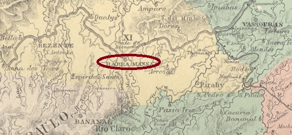
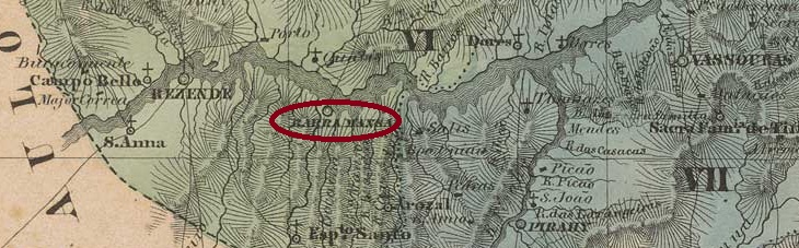
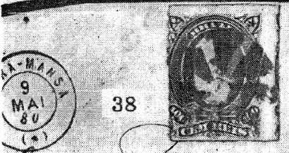
The former Freguesia de S. Sebastião da Barra Mansa was founded around 1820 at the Vila of Resende on the south bank of the Paraiba do Sul, 140 km northwest of the capital Rio de Janeiro. It became a vila in October 1832 and a town in October 1857.
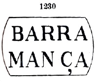
As Nova Monteiro writes in Administrações e Agencias Postaes do Brasil Imperio (Brasil Filatelico/RJ, 1934-5; Reprint SPP 1994-1999), there was a post office at the site from March 1833. The first postmark is BRJ-0145a, found so far with dates between 1843 and 1863 and known through Paulo Ayres in Catálogo de Carimbos Brasil-Império (S. Paulo, 1937, 1942) as No. 1230:
BRJ-0145a (P.A. 1230)
It was followed by BRJ-0145b (image from the Internet), which occurred in the period 1854ff-1866ff:
BRJ-0145b (Imperio e rep – estudo)
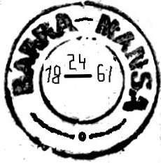
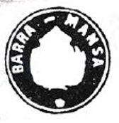
Then came the French type BRJ-0145c (Coll. Klerman W. Lopes): a double circle with the inscription BARRA – MANSA at the top and the star between brackets at the bottom, with internal dates from 1874 to 1886. The next postmark is BRJ-0145d (image by Luís C. Fritzen): a double circle with the inscription BARRA MANSA at the top and an ornament in lozenge at the bottom, formed by four small lozenges. It also appears in blue and red with dates from 1885 to 1897.
The last postmark in the Empire is BRJ-0145e (image from the Internet). In this double circle we have the inscription BARRA – MANSA at the top and an ornament in branches at the bottom, dates in the middle: 1889 to 1894. But before it, there came BRJ-0145f, already known through P. Ayres (op. cit.), unfortunately without dates.
BRJ-0145f (P.A. p. 144)
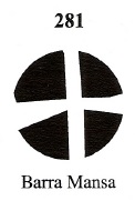
Alfred J. Dingler and Klerman w. Lopes have also registered a mute cancellation from Barra Mansa in Mute Cancellations of the Brazil Empire / Carimbos Mudos do Brasil Império, /Brazil Philatelic Association, Rio de Janeiro, 2000) under No. 281 :
BPA 281
Another mute postmark came to light through R. Koester in Carimbologia III:
1880-1883 (RK)Villiers de l’Ile Adam: Carta (…) da Provincia do Rio de Janeiro, 1850
Die ehemalige Freguesia de S. Sebastião da Barra Mansa wurde um 1820 gegründet und lag bei der Vila von Resende am Südufer des Paraiba do Sul, 140 km nordwestlich der Hauptstadt Rio de Janeiro entfernt. Im Oktober 1832 wurde daraus eine Vila und im Oktober 1857 eine Stadt.
Wie Nova Monteiro in Administrações e Agencias Postaes do Brasil Imperio (Brasil Filatelico/RJ, 1934-5; Reprint SPP 1994-1999) schreibt, gab es vor Ort ein Postamt seit März 1833. Der erste Poststempel ist BRJ-0145a, der bisher mit Daten zwischen 1843 und 1863 gefunden wurde und durch Paulo Ayres in Catálogo de Carimbos Brasil-Império (S. Paulo, 1937, 1942) unter der Nr. 1230 bekannt ist:
BRJ-0145a (P.A. 1230)
Ihm folgte BRJ-0145b (Abb. aus dem Internet), der im Zeitraum 1854ff-1866ff vorgekommen ist:
BRJ-0145b (Imperio e Rep – estudo)
Danach kam der französische Typus BRJ-0145c (Samml. Klerman W. Lopes): ein Doppelkreis mit der Inschrift BARRA – MANSA oben und dem Stern zwischen Klammern unten, dazu inneren Daten von 1874 bis 1886. Der nächste Poststempel ist BRJ-0145d (Abb. Luís C. Fritzen): ein doppelkreis mit der Inschrift BARRA MANSA oben und einem Ornament in Raute unten, das aus vier kleinen Rauten gebildet wird. Er kommt auch in Blau und Rot mit Daten von 1885 bis 1897 vor.
Der letzte Poststempel im Kaiserreich ist BRJ-0145e (Abb. aus dem Internet). In diesem Doppelkreis haben wir oben die Inschrift BARRA – MANSA und unten ein Ornament in Zweigen, Daten in der Mitte: 1889 bis 1894. Vor ihm kam aber BRJ-0145f, der bereits durch P. Ayres (op. cit.) bekannt ist, leider ohne Datumsangaben.
BRJ-0145f (P.A. S. 144)
Alfred J. Dingler und Klerman W. Lopes haben auch eine stumme Entwertung aus Barra Mansa in Mute Cancellations of the Brazil Empire / Carimbos Mudos do Brasil Império, /Brazil Philatelic Association, Rio de Janeiro, 2000) unter Nr. 281 registriert :
BPA 281
Eine weitere stumme Abstempelung kam durch R. Koester in Carimbologia III zu Tage: