Categories
Carimbologia A-B

Barra Longa, Minas Gerais (BMG-0240)

Villiers de l’Ile Adam: Carta (…) da Provincia de Minas Geraes, 1849

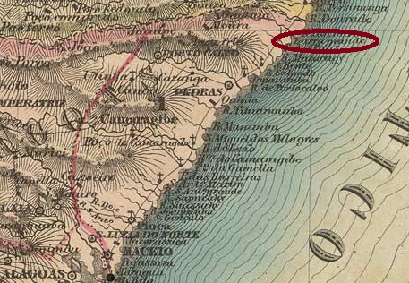
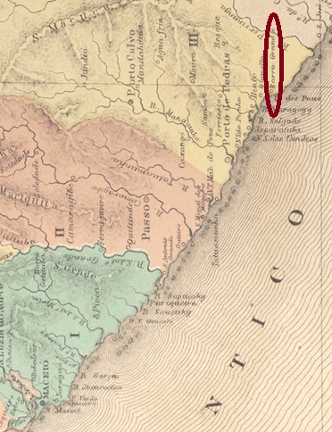
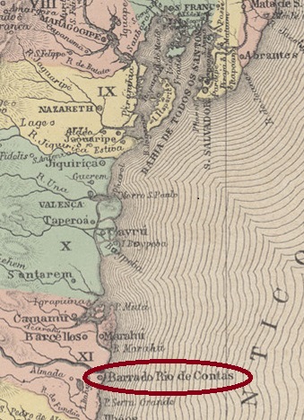
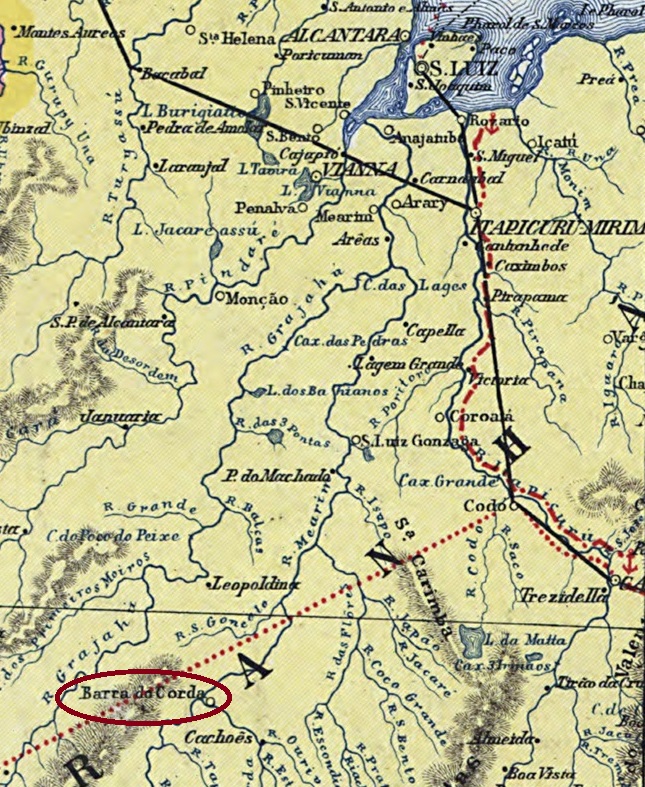
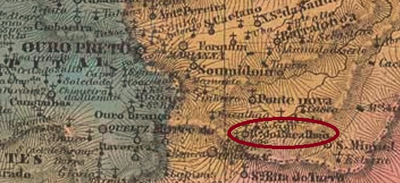
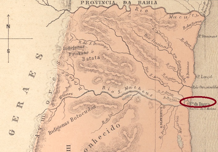
The freguesia of S. José da Barra Longa was founded as early as February 1740, it belonged to the Vila of Mariana and was located on the south bank of the river Carmo, 70 km east of the later provincial capital Ouro Preto. In April 1841, the village was promoted to a Vila, but in July 1857 it was downgraded as a district in the Município of Ponte Nova. Barra Longa then moved back to the Município of Mariana (in October 1870), returning to Ponte Nova in September 1923. Barra Longa has been an independent município since December 1938.

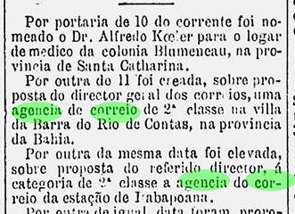
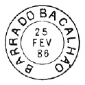
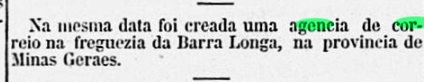
Two dates of origin have been found for the local post office. The first was in February 1865, as reported by the Rio press:

Correio Mercantil/RJ, 20.02.1865

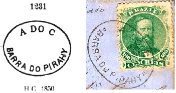
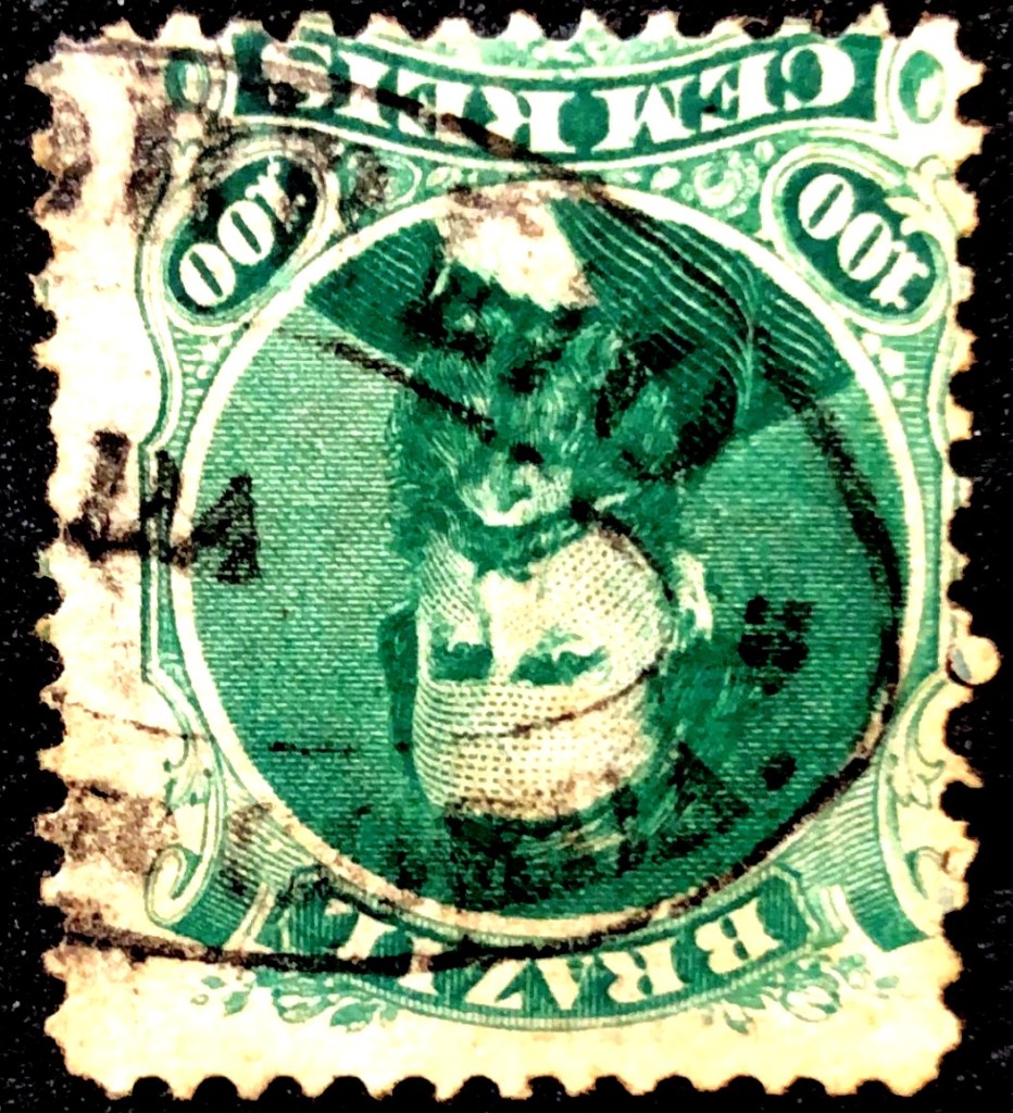
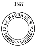
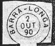
The second date is one month later and was found by Paula Sobrinho in História Postal de Minas Gerais (Belo Horizonte, 1997), and adopted by R. Koester in Carimbologia III. This could be the date of the commissioning of the agency. The only postmark in the Empire so far is BMG-0240b, found with dates from 1879 to 1890 and already shown by R. Koester (op. cit.):

BMG-0240b (RK)

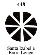
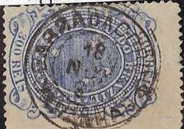
James A. Dingler and Klerman W. Lopes have also presented a mute cancellation from Barra Longa in Mute Cancellations of the Brazil Empire / Carimbos Mudos do Brasil Império (Brazil Philatelic Association, Rio de Janeiro, 2000) under No. 448, which was used from about 1878 to 1882:

BPA 448
Atlas do Imperio do Brasil, 1868

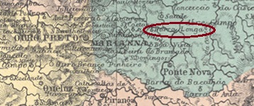
Die Freguesia von S. José da Barra Longa wurde bereits im Februar 1740 gegründet, sie gehörte der Vila von Mariana und lag am Südufer des Flusses Carmo, 70 km östlich der späteren Provinzhauptstadt Ouro Preto entfernt. Im April 1841 stieg der Ort zur Vila auf, wurde aber im Juli 1857 als Distrikt im Município von Ponte Nova herabgestuft. Danach wechselte Barra Longa zurück zum Município von Mariana (im Oktober 1870), um im September 1923 zu Ponte Nova zurückzukehren. Seit Dezember 1938 ist Barra Longa ein eigenständiger Município.

Es wurden zwei Entstegungsdaten fürs örtliche Postamt gefunden. Erstmals im Februar 1865, wie die Presse aus Rio berichtete:

Correio Mercantil/RJ, 20.02.1865

Das zweite Datum liegt ein Monat später und wurde durch Paula Sobrinho in História Postal de Minas Gerais (Belo Horizonte, 1997) ermittelt, sowie von R. Koester in Carimbologia III übernommen. Das könnte das Datum der Inbetriebnahme der Agentur sein. Der bisher einzige Ortsstempel im Kaiserreich ist BMG-0240b, der mit Daten von 1879 bis 1890 gefunden und bereits durck R. Koester (op. cit.) gezeigt wurde:

BMG-0240b (RK)

James A. Dingler und Klerman W. Lopes haben auch eine stumme Entwertung aus Barra Longa in Mute Cancellations of the Brazil Empire / Carimbos Mudos do Brasil Império (Brazil Philatelic Association, Rio de Janeiro, 2000) unter Nr. 448 präsentiert, die von ca. 1878 bis 1882 verwendet wurde:

BPA 448
Categories
Carimbologia A-B

Barra Grande, Alagoas (BAL-0290)

Villiers de l’Ile Adam: Carta (…) das Provincias de Pernambuco, Alagoas e Sergipe, 1848

Barra Grande was a small port on the north bank of the estuary of the Rio de Paus into the Atlantic Ocean, belonging to the Freguesia of São Bento in the imperial Município of Porto Calvo, 150 km northeast of the provincial capital of Maceió. In April 1875, the place changed to the newly created Município of Isabel, which was called Maragogy from the following year.

Aldo Cardoso writes in Contribuição para a História dos Correios de Alagoas (Maceió, 1969) that there was a post office there from July 1869. The Almanac for the Province of Alagoas for 1874 even names the post agent:

Almanak da Provincia das Alagoas, 1874

Since this agency is missing from the Almanac edition for 1877, we may assume that it was closed around 1876. Since then, no imperial post office has been mentioned for Barra Grande. So far, no postmark from the period has been found either.

Atlas do Imperio do Brasil, 1868

Barra Grande war ein kleiner Hafen am Nordufer der Flussmündung des Rio de Paus in den Atlantik, der zur Freguesia von São Bento im kaiserlichen Município von Porto Calvo gehörte und 150 km nordöstlich der Provinzhauptstadt Maceió lag. Im April 1875 wechselte der Ort zum neu gegründeten Município von Isabel, der ab dem folgenden Jahr Maragogy hieß.

Aldo Cardoso schreibt in Contribuição para a História dos Correios de Alagoas (Maceió, 1969), dass es dort ab Juli 1869 ein Postamt gab. Der Almanak für die Provinz Alagoas für 1874 nennt sogar seinen Postagenten:

Almanak da Provincia das Alagoas, 1874

Da diese Agentur in der Almanak-Ausgabe für 1877 fehlt, darf man annehmen, dass sie um 1876 geschlossen wurde. Seitdem wurde für Barra Grande kein kaiserliches Postamt mehr erwähnt. Bisher wurde auch kein Poststempel aus der Zeit gefunden.

Categories
Carimbologia A-B

Barra do Rio Negro, Pará – Amazonas (BPA-0015)

Atlas do Imperio do Brasil, 1868

Another name: Manaos/Manaus (1832)

Barra do Rio Negro is the former name of the present-day Amazon metropolis of Manaus. The town was founded around 1670, when the fortress of S. José da Barra do Rio Negro was built at the mouth of the river into the Amazon. The place became a freguesia in 1695, also serving as the capital of the former Capitania of S. José do Rio Negro, until its designation as a vila in 1790.

In November 1832, the Vila was renamed Manaos, in memory of an Indian tribe of the region. It then belonged to the province of Grão-Pará. In October 1848, it was promoted to the city of N. Sra. da Conceição da Barra do Rio Negro, which became the capital of the then newly founded province of Amazonas in September 1850. Finally, in September 1856, the name Manaus returned for good.

As Nova Monteiro writes in Administrações e Agencias Postaes do Brasil Imperio (Brasil Filatelico/RJ, 1934-5; Reprint SPP 1994-1999), the local postal agency was created in March 1829. So far, no imperial postmark has been seen under Barra do Rio Negro.

Villiers de l’Ile Adam: Carta (…) das Provincias do Grão-Pará e Alto Amazonas, 1850

Anderer Name: Manaos/Manaus (1832)

Barra do Rio Negro ist der frühere Name der heutigen Amazonasmetropole Manaus. Die Ortsgründung fand um 1670 statt, als die Festung von S. José da Barra do Rio Negro an der Mündung des Flusses in den Amazonas errichtet wurde. Der Ort wurde 1695 zu einer Freguesia, die auch als „Hauptstadt“ der ehemaligen Capitania von S. José do Rio Negro fungierte, bis zur Ernennung zur Vila im Jahre 1790.

Im November 1832 wurde die Vila zu Manaos umbenannt, in Erinnerung an einem Indianerstamm der Region. Da gehörte sie dann der Provinz Grão-Pará. Im Oktober 1848 erfolgte der Aufstieg zur Stadt N. Sra. da Conceição da Barra do Rio Negro, die im September 1850 zur Hauptstadt der damals neu gegründeten Provinz Amazonas wurde. Schließlich kehrte im September 1856 der Name Manaus endgültig zurück.

Wie Nova Monteiro in Administrações e Agencias Postaes do Brasil Imperio, (Brasil Filatelico/RJ, 1934-5; Reprint SPP 1994-1999) schreibt, wurde die örtliche Postagentur im März 1829 ins Leben gerufen. Bisher wurde kein kaiserlicher Poststempel unter Barra do Rio Negro gesehen.

Categories
Carimbologia A-B

Barra do Rio de Contas, Bahia (BBA-0110)

Villiers de l’Ile Adam: Carta (…) da Provincia da Bahia, 1848

Another name: Itacaré (1931)

The freguesia of Barra do Rio de Contas originated in 1718 on the southern shore of the mouth of the Rio de Contas into the Atlantic Ocean, it was located 250 km south of the later provincial capital Salvador da Bahia and belonged to the Vila of Valença. The place rose to the status of Vila in January 1732 and has been called Itacaré since December 1931. The word from the Tupi-Guarani means stone crocodile.

There were no less than four dates for the creation of the post office there. First in May 1832, as Nova Monteiro writes in Administrações e Agencias Postaes do Brasil Imperio, (Brasil Filatelico/RJ, 1934-5; Reprint SPP 1994-1999). Then in 1852, as can be read in the report of the Imperial Ministry:

Relatorio do Ministerio do Imperio, 1852

The next creation should have taken place in 1858, as shown in the Directory of Imperial Post Offices (Tabella das Agencias do Correio do Imperio, Rio de Janeiro, 1885). And finally, in February 1882, the Rio press reported the new postal agency in Barra do Rio de Contas:

Gazeta de Noticias/RJ, 12.02.1882

Despite the many creation dates, no imperial postmark has yet been seen from this place.

Atlas do Imperio do Brasil, 1868

Anderer Name: Itacaré (1931)Die Freguesia von Barra do Rio de Contas entstand 1718 am Südufer der Mündung des Rio de Contas in den Atlantik, sie lag 250 km südlich der späteren Provinzhauptstadt Salvador da Bahia und gehörte der Vila von Valença. Der Ort stieg im Januar 1732 zur Vila auf und heißt seit Dezember 1931 Itacaré. Das Wort aus dem Tupi-Guarani bedeutet Krokodil aus Stein.

Es wurden nicht weniger als vier Zeitpunkte für die Entstehung des Postamts dort. Erstmals im Mai 1832, wie Nova Monteiro in Administrações e Agencias Postaes do Brasil Imperio, (Brasil Filatelico/RJ, 1934-5; Reprint SPP 1994-1999) schreibt. Dann 1852, wie im Bericht des Imperialministeriums zu lesen ist:

Relatorio do Ministerio do Imperio, 1852

Die nächste Gründung des Postamts sollte 1858 stattgefunden haben, wie aus dem Verzeichnis der kaiserlichen Postämter (Tabella das Agencias do Correio do Imperio, Rio de Janeiro, 1885) hervorgeht. Und schließlich berichtete die Presse aus Rio im Februar 1882 über die Entstehung einer Postagentur in Barra do Rio de Contas:

Gazeta de Noticias/RJ, 12.02.1882

Trotz der vielen Gründungsdaten wurde bisher kein kaiserlicher Poststempel aus diesem Ort gesehen.

Categories
Carimbologia A-B

Barra do Pirahy (train station/Bahnhof), Rio de Janeiro (BRJ-0140)

Atlas do Imperio do Brasil, 1868

Barra do Pirahy station was inaugurated in July 1864 by the E.F. D. Pedro II railway company (Main Line) and was located at the mouth of the Piraí River in the Paraíba do Sul in the Município of Pirahy, 120 km northwest of the capital Rio de Janeiro. The railway line went to the E.F. Central do Brasil in 1889 and to Rede Ferroviária Federal S.A. in 1975 (estacoesferroviarias.com.br). Since 1996 it has been operated by the MRS railway company.

1881 (in estacoesferroviarias.com.br)
2019 (photo Júlio C. Alves, in estacoesferroviarias.com.br)

The settlement around the station continued to grow, becoming a freguesia of S. Benedicto da Barra do Pirahy in November 1885 and a vila in its own município in February 1890.

As Nova Monteiro writes in Administrações e Agencias Postaes do Brasil Imperio (Brasil Filatelico/RJ, 1934-5; Reprint SPP 1994-1999), there had been a post office there since July 1864, before the station was opened. The first postmark is BRJ-0140a which was used until at least 1874 and is already known by P. Ayres in Catálogo de Carimbos Brasil-Império, (S. Paulo, 1937, 1942) under No. 1231. However, in his illustration the dots to the right and left of the place name are missing, as can be seen from the picture (Coll. José A. Junges):

BRJ-0140a (P.A. 1231 recte JJ)

It was followed by BRJ-0140b (Coll. José A. Junges): a double circle with the inscription B. DE PIRAHY at the top. This postmark also occurs in green and has been found so far with internal dates from 1879 to 1893.

James A. Dingler and Klerman W. Lopes, in Mute Cancellations of the Brazil Empire / Carimbos Mudos do Brasil Império (Brazil Philatelic Association, Rio de Janeiro, 2000), recorded two mute cancellations from Barra do Pirahy, with nos. 279 (also P. Ayres no. 19, found with date from 1879) and 1435 respectively:

BPA 279 (P.A. 19, 1879) – 1435
Almanak Laemmert, 1866

Der Bahnhof Barra do Pirahy wurde im Juli 1864 durch die Bahngesellschaft E.F. D. Pedro II (Hauptlinie) eingeweiht und lag an der Mündung des Flusses Piraí in den Paraíba do Sul im Município von Pirahy, 120 km nordwestlich der Hauptstadt Rio de Janeiro entfernt. Die Bahnlinie ging 1889 zur E.F. Central do Brasil und 1975 zur rede Ferroviária Federal S.A. (estacoesferroviarias.com.br). Seit 1996 wird sie von der MRS-Bahngesellschaft betrieben.

1881 (in estacoesferroviarias.com.br)
2019 (Foto Júlio C. Alves, in estacoesferroviarias.com.br)

Die Siedlung um den Bahnhof wuchs weiter, wurde im November 1885 zur Freguesia von S. Benedicto da Barra do Pirahy und im Februar 1890 zu einer Vila im eigenen Município.

Wie Nova Monteiro in Administrações e Agencias Postaes do Brasil Imperio (Brasil Filatelico/RJ, 1934-5; Reprint SPP 1994-1999) schreibt, gab es dort ein Postamt seit Juli 1864 und damit noch vor der Inbetriebnahme des Bahnhofs. Der erste Poststempel ist BRJ-0140a der bis mindestens 1874 benutzt wurde und bereits durch P. Ayres in Catálogo de Carimbos Brasil-Império, (S. Paulo, 1937, 1942) unter der Nr. 1231 bekannt ist. Allerdings fehlen in seiner Abbildung die Punkte rechts und links des Ortsnamens, wie man aus der Bild (Samml. José A. Junges) entnehmen kann:

BRJ-0140a (P.A. 1231 recte JJ)

Ihm folgte BRJ-0140b (Samml. José A. Junges): ein Doppelkreis mit der Inschrift B. DE PIRAHY oben. Dieser Poststempel kommt auch in grün vor und wurde bisher mit inneren Daten von 1879 bis 1893 gefunden.

James A. Dingler und Klerman W. Lopes registrierten in Mute Cancellations of the Brazil Empire / Carimbos Mudos do Brasil Império (Brazil Philatelic Association, Rio de Janeiro, 2000) zwei stumme Entwertungen aus Barra do Pirahy, mit Nr. 279 (auch P. Ayres Nr. 19, gefunden mit Datum aus 1879) resp. 1435:

BPA 279 (P.A. 19, 1879) – 1435
Categories
Carimbologia A-B

Barra do Mossoró, Rio Grande do Norte (BRN-0035)

Atlas do Imperio do Brasil, 1868

Other names: Porto da Barra de Mossoró, Areia Branca (ca. 1890)

Around 1872, the settlement of Porto da Barra de Mossoró was established on the west bank of the Apodi River on the provincial border with Ceará, 290 km northwest of the provincial capital Natal. The name was later shortened to Barra do Mossoró and around 1890 changed to Areia Branca (White Sand), now as a district. This was the name of the settlement on the other side of the Apodi. Areia Branca became a vila in February 1892 and has been a town since October 1927.

As R. Koester writes in Carimbologia III, there was a post office there since June 1872. The only 19th century postmark so far is BRN-0035b (image: Jorge L. Pedreira): a double circle with the inscription BARRA DO MOSSORÓ at the top and an ornament in lozenge below. Two copies found, dated 1890 in the centre.

Villiers de l’Ile Adam: Carta (…) das Provincias do Rio Grande do Norte e Parahiba, 1848

Andere Namen: Porto da Barra de Mossoró, Areia Branca (ca. 1890)

Um 1872 entstand die Siedlung Porto da Barra de Mossoró am Westufer des Flusses Apodi an der Provinzgrenze zu Ceará, 290 km nordwestlich der Provinzhauptstadt Natal. Der Name wurde später zu Barra do Mossoró abgekürzt und um 1890 zu Areia Branca (Weißer Sand) geändert, nun als Distrikt. So hieß die Siedlung auf der anderen Seite des Apodi. Areia Branca wurde im Februar 1892 eine Vila und ist seit Oktober 1927 eine Stadt.

Wie R. Koester in Carimbologia III schreibt, gab es dort ein Postamt seit Juni 1872. Der bisher einzige Poststempel im 19 Jahrhundert ist BRN-0035b (Abb. Jorge L. Pedreira): ein Doppelkreis mit der Inschrift BARRA DO MOSSORÓ oben und einem Ornament in Raute unten. Zwei Exemplare gefunden, datiert 1890 in der Mitte.

Categories
Carimbologia A-B

Barra do Macabu, Rio de Janeiro (BRJ-0123)

Bellegard-Niemeyer: Carta Corographica da Provincia do Rio de Janeiro, 1867

The Macabu River rises from the mountain range of the same name in the state of Rio de Janeiro and used to flow eastwards for about 120 km to its mouth in Lagoa Feia (Ugly Lake). With the construction of a hydroelectric power plant at the Tapera Dam in 1950 in the Município of Trajano de Morais, the Macabu was diverted through an underground channel into the Macaé River. However, 5 km further on, the river rises again and resumes its original direction. So, the Macabu has two sources and two mouths.

At the mouth of the river at Lagoa Feia there was a now disappeared settlement called Barra do Macabu, which belonged to the Freguesia of Dores do Macabu and was in the Município of Campos, 250 km northeast of the capital Rio de Janeiro.

The Barra do Macabu post office was created in August 1869, as Nova Monteiro writes in Administrações e Agencias Postaes do Brasil Imperio (Brasil Filatelico/RJ, 1934-5; Reprint SPP 1994-1999), but was already closed “around 1875”, as Paulo Novaes tells us in agenciaspostais.com.br. No imperial postmark from this locality has been found so far, it must be extremely rare.

Almanak Laemmert, 1892

Der Fluss Macabu entspringt dem gleichnamigen Gebirge im Bundesstaat Rio de Janeiro und floß früher ostwärts ca. 120 km bis zur Mündung in die Lagoa Feia (Häßlicher See). Mit dem Bau eines Wasserkraftwerks am Tapera-Staudamm 1950 im Município von Trajano de Morais wurde der Macabu durch einen unterirdischen Kanal in den Fluss Macaé umgeleitet. Allerdings entspringt 5 km weiter der Fluss nochmals und nimmt die ursprüngliche Richtung wieder ein. Also hat der Macabu zwei Quellen und zwei Mündungen.

An der Flussmündung zur Lagoa Feia gab es eine inzwischen verschwundene Siedlung namens Barra do Macabu, die der Freguesia von Dores do Macabu angehörte und im Município von Campos lag, 250 km nordöstlich der Hauptstadt Rio de Janeiro entfernt.

Das Postamt Barra do Macabu entstand im August 1869, wie Nova Monteiro in Administrações e Agencias Postaes do Brasil Imperio (Brasil Filatelico/RJ, 1934-5; Reprint SPP 1994-1999) schreibt, wurde aber bereits “ca. 1875” geschlossen, wie Paulo Novaes uns in agenciaspostais.com.br berichtet. Bisher wurde kein kaiserlicher Poststempel aus dieser Ortschaft gefunden, er muss äußerst selten sein.

Categories
Carimbologia A-B

Barra do Corda, Maranhão (BMA-0035)

Atlas do Imperio do Brasil, 1868

Text update on January 30, 2024

The chapel of Barra do Corda (or da Corda) was built in November 1849 at the mouth of the Corda River in the Mearim in the Município of Chapada, 450 km south of the provincial capital São Luís. The place rose to the status of vila in May 1854 and town in June 1894.

The post office, ca. 1975 (IBGE)

There had been a post office there since August 1856, as shown in the postal report (Relatorio Postal) for 1887. The regional official press gives April 1st of that year as the creation date:

Publicador Maranhense, 06/05/1856

The oldest postmark BMA-0035a was found by philatelist Felipe Piccinini on a D. Pedro issue of 1866:

BMA-0035a (FP) 1866ff

BMA-0035c appeared much later (illustration from the Internet):

BMA-0035c (EB) 1891-1900ff
Carta da Republica dos Estados Unidos do Brazil, 1892

Textaktualisierung am 30.01.2024

Die Kapelle von Barra do Corda (oder auch da Corda) wurde im November 1849 an der Mündung des Flusses Corda in den Mearim im Município von Chapada, 450 km südlich der Provinzhauptstadt São Luís. Der Ort stieg im Mai 1854 zur Vila und im Juni 1894 zur Stadt auf.

Das Postamt, ca. 1975 (IBGE)

Dort gab es ein Postamt seit August 1856, wie aus dem Postbericht (Relatorio Postal) für 1887 hervorgeht. Die regionale Amtspresse gibt dafür den 1. April d.J. an:

Publicador Maranhense, 06.05.1856

Der älteste Poststempel BMA-0035a wurde vom Philatelisten Felipe Piccinini auf einer D. Pedro-Ausgabe von 1866 gefunden:

BMA-0035a (FP) 1866ff

Viel später erschien BMA-0035c (Abb. aus dem Internet):

BMA-0035c (EB) 1891-1900ff
Categories
Carimbologia A-B

Barra do Bacalhao, Minas Gerais (BMG-0225)

Atlas do Imperio do Brasil, 1868

Other names: Sant’Anna de Guaraciaba, Guaraciaba (1948).

Bacalhao (today spelled bacalhau) is the Portuguese name for the codfish (Gadus morhua) but also the name of a river in Minas Gerais, for some unknown reason. The parish of Sant’Anna da Barra do Bacalhao was established in July 1832, located on the north bank of this Bacalhau River, just before it flows into the Piranga, 90 km east of the provincial capital Ouro Preto. The place became a freguesia called Sant’Anna de Guaraciaba in October 1884 and has been the Município of Guaraciaba since December 1948. The Tupi word means hair bright as sunbeams.

As the postal report (Relatorio Postal) for 1887 states, there was a post office on site since September 1878. The imperial postmark is BMG-0225a and has already been shown by Paulo Ayres in the Catálogo de Carimbos Brasil-Império (S. Paulo, 1937, 1942):

BMG-0225a (P.A. p. 120) 1886
Villiers de l’Ile Adam: Carta (…) da Provincia de Minas Geraes, 1849

Andere Namen: Sant’Anna de Guaraciaba, Guaraciaba (1948)

Bacalhao (heute bacalhau geschrieben) ist die port. Bezeichnung für den Kabeljau (Gadus morhua) aber auch der Name eines Flusses in Minas Gerais geworden, aus unerfindlichen Gründen. Die Pfarrei von Sant’Anna da Barra do Bacalhao wurde im Juli 1832 errichtet und lag am Nordufer dieses Flusses Bacalhau kurz vor der Einmündung in den Piranga, 90 km östlich der Provinzhauptstadt Ouro Preto entfernt. Der Ort wurde im Oktober 1884 zu einer Freguesia mit Namen Sant’Anna de Guaraciaba und ist seit Dezember 1948 der Sitz des Município von Guaraciaba. Das Tupi-Wort bedeutet Haare hell wie Sonnenstrahlen.

Wie im Postreport (Relatorio Postal) für 1887 geschrieben, gab es ein Postamt vor Ort seit September 1878. Der kaiserliche Poststempel ist BMG-0225a und wurde bereits durch Paulo Ayres im Catálogo de Carimbos Brasil-Império (S. Paulo, 1937, 1942) abgebildet:

BMG-0225a (P.A. S. 120) 1886
Categories
Carimbologia A-B

Barra de São Matheus, Espírito Santo (BES-0035)

Atlas do Imperio do Brasil, 1868

Text update of March 10, 2023

Other name: Conceição da Barra (1891)

The parish of N. Sra. da Conceição da Barra de S. Matheus was founded in August 1831 and was situated on the north bank of the mouth of the river S. Mateus in the area of the vila of the same name, 250 km north of the provincial capital Vitória. It became a vila in April 1833 and has been the town of Conceição da Barra since September 1891.

Nova Monteiro writes in Administrações e Agencias Postaes do Brasil Imperio (Brasil Filatelico/RJ, 1934-5; Reprint SPP 1994-1999) that there has been a post office there since October 1831. Three postmarks for the empire have been found so far, probably the very first one among them is still missing.

Presumably BES-0035a is the first postmark, which has been partially reconstructed by two examples from the Klerman W. Lopes e Fuad Ferreira Fo. collections:

BES-0035a (KL-FF) 1866ff-1876ff

BES-0035b was in use between ca. 1866 and 1878ff and was already presented by Paulo Ayres (Catálogo de Carimbos Brasil-Império, S. Paulo, 1937, 1942) under no. 1557:

BES-0035b (P.A. 1557)

Then came BES-0035c (image: Jorge L. Pedreira): a double circle with the inscription B. DE S. MATHEUS at the top and internal dates from 1877 to 1897. Through R. Koester (Carimbologia III) we also know BES-0035d, which occurs with dates from 1885 in blue and red:

BES-0035d (RK)
Villiers de l’Ile Adam: Carta (…) da Provincia do Espirito Santo, 1850

Textaktualisierung vom 10.03.2023

Anderer Name: Conceição da Barra (1891)

Die Pfarrei von N. Sra. da Conceição da Barra de S. Matheus wurde im August 1831 gegründet und lag am Nordufer der Mündung von Fluss S. Mateus im Gebiet der gleichnamigen Vila, 250 km nördlich der Provinzhauptstadt Vitória. Der Ort wurde im April 1833 eine Vila und ist seit September 1891 die Stadt Conceição da Barra.

Nova Monteiro schreibt in Administrações e Agencias Postaes do Brasil Imperio (Brasil Filatelico/RJ, 1934-5; Reprint SPP 1994-1999), dass es dort seit Oktober 1831 ein Postamt gibt.

Vermutlich ist BES-0035a der erste Poststempel, er wurde durch zwei Beispiele aus den Sammlungen Klerman W. Lopes e Fuad Ferreira Fo. teilweise rekonstruiert:

BES-0035a (KL-FF), 1866ff-1876ff

BES-0035b war zwischen ca. 1866 und 1878ff verwendet und wurde bereits durch Paulo Ayres (Catálogo de Carimbos Brasil-Império, S. Paulo, 1937, 1942) unter der Nr. 1557 vorgestellt:

BES-0035b (P.A. 1557)

Danach kam BES-0035c (Abb. Jorge L. Pedreira): ein Doppelkreis mit der Inschrift B. DE S. MATHEUS oben und inneren Daten von 1877 bis 1897. Durch R. Koester (Carimbologia III) kennen wir auch BES-0035d (RK) der mit Daten von 1885 in den Farben Blau und Rot vorkommt:

BES-0035d (RK)