Categories
Carimbologia A-B

Barão de Cotegipe (train station/Bahnhof), Minas Gerais (BMG-0215)

Estado de Minas Geraes, 1910

Text update on March 18, 2024

Another name: Cotegipe

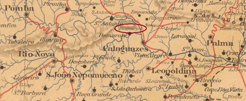
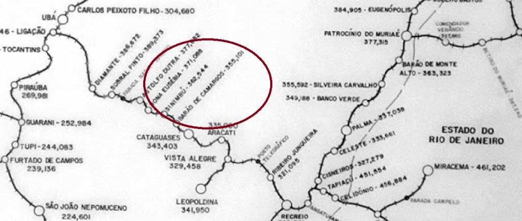
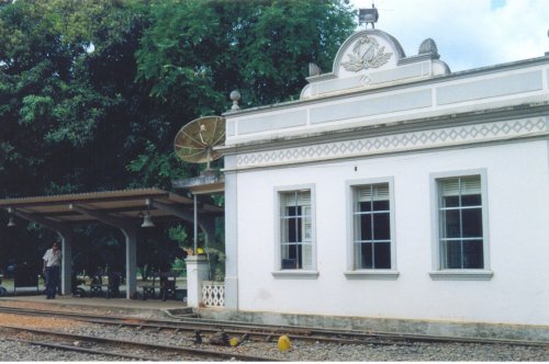
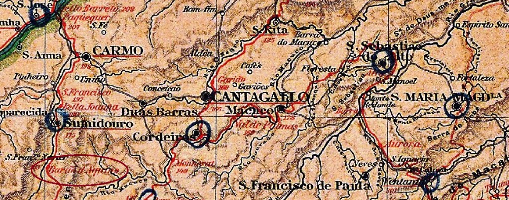
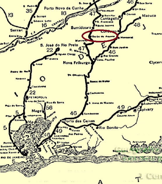
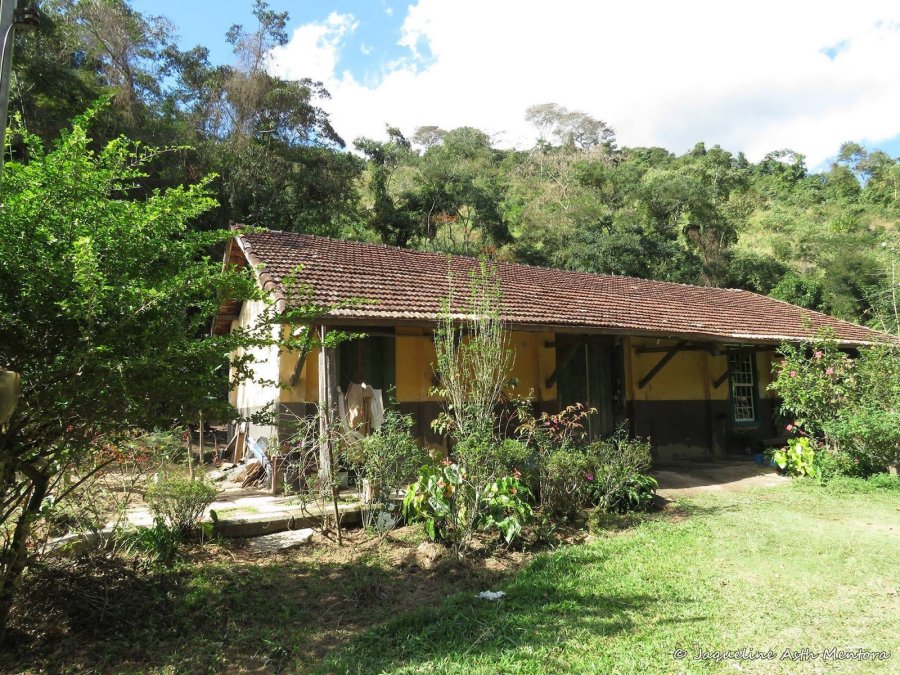
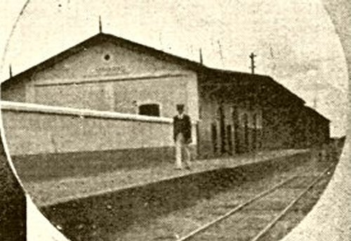
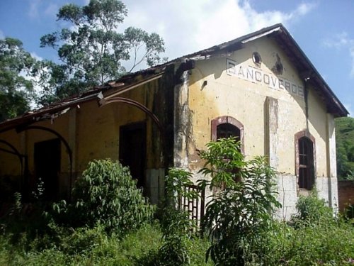
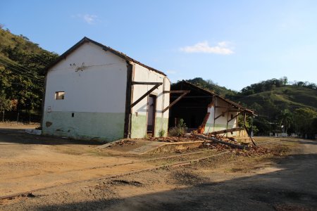
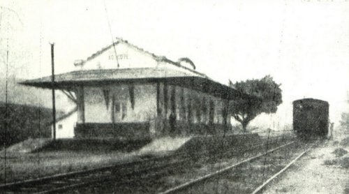
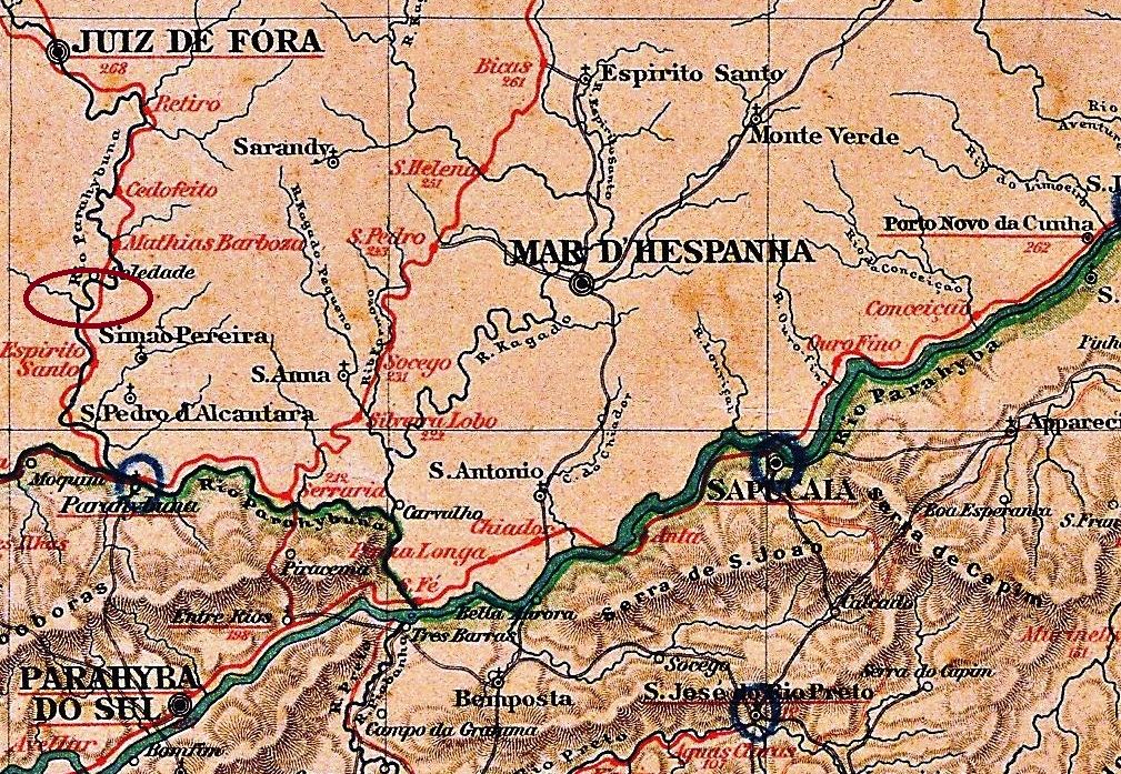
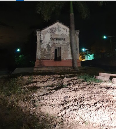
Barão de Cotegipe station was inaugurated in November 1885 by the E.F. Dom Pedro II railway company (Central Line) and was located at the confluence of the Rio do Peixe and the Paraibuna, in the Município of Juiz de Fora, 240 km south of the provincial capital Ouro Preto. In 1889, the railway line went to E.F. Central do Brasil and from 1975 until its closure in 1996, it belonged to Rede Ferroviária Federal S.A. (estacoesferroviarias.com.br). Today, the rails are still there, but the station building has been abadoned:

ca.1915 (Album de Juiz de Fora, in estacoesferroviarias.com.br)
2000 (Photo: Victor Chrispim)

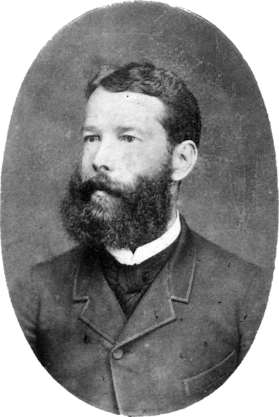
With the Republic, the station was renamed Cotegipe. The Baron of Cotegipe’s real name was João Mauricio Wanderley (1815-1889), he was an important politician in the Empire. From September 1923, the station belonged to the Município of Mathias Barbosa, and since December 1962 it has been in the Município of Simão Pereira.

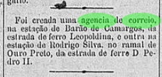
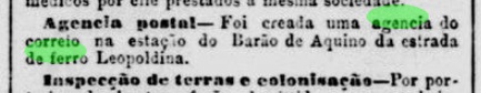
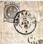
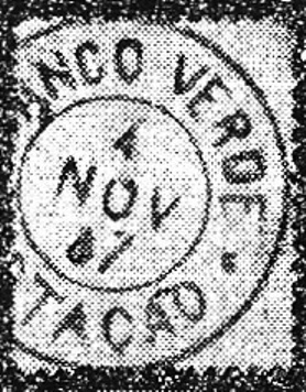
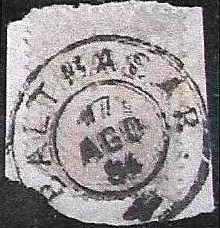
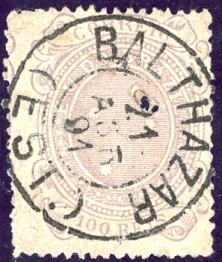
As Paula Sobrinho writes in História Postal de Minas Gerais (Belo Horizonte, 1997), there was a post office at the station since December 1885. The first imperial postmark is now BMG-0215a (Fig. Felzmann Auctions):

BMG-0215a (FA) 1887

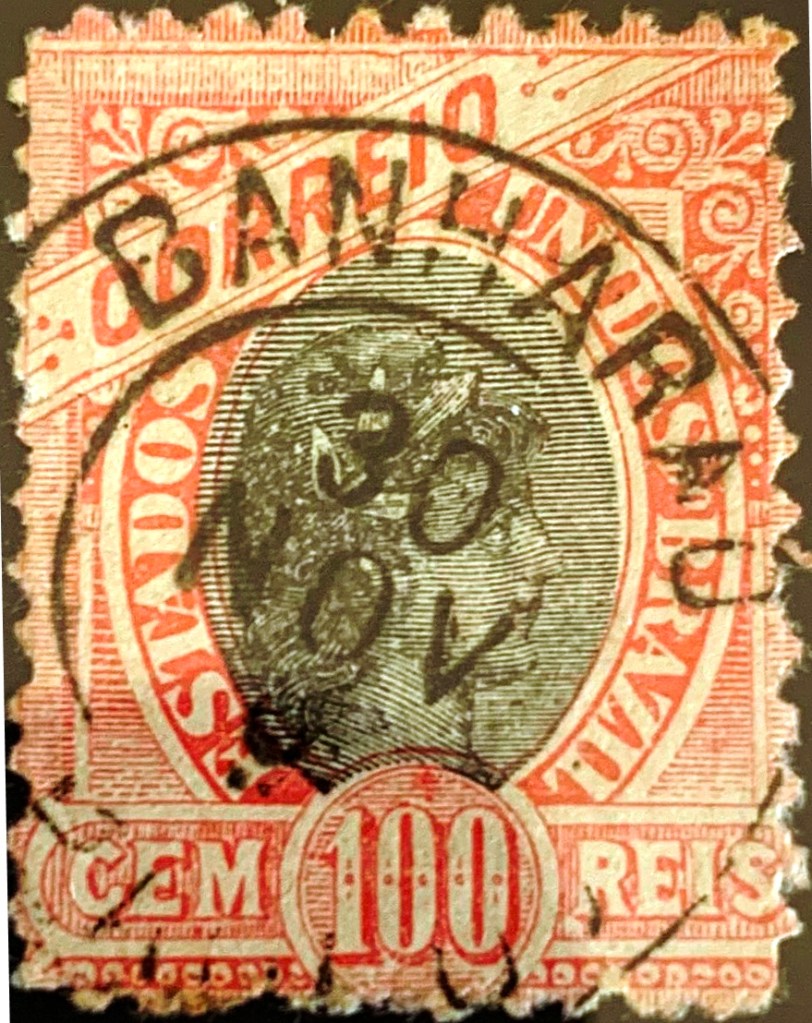
Its successor BMG-0215b (illustration from the Internet): a double circle with the inscriptions B. DO COTEGIPE at the top and (MINAS) at the bottom. The dates in the middle are from the period 1888-1897.

Almanak Laemmert, 1892

Textaktualisierung am 18. März 2024

Anderer Name: Cotegipe

Der Bahnhof Barão de Cotegipe wurde im November 1885 durch die E.F. Dom Pedro II Bahngesellschaft (Hauptlinie) eingeweiht und lag an der Mündung vom Rio do Peixe in den Paraibuna, im Município von Juiz de Fora, 240 km südlich der Provinzhauptstadt Ouro Preto enfernt. 1889 ging die Bahnlinie zur E.F. Central do Brasil und von 1975 bis zur Stilllegung 1996 gehörte sie der Rede Ferroviária Federal S.A. (estacoesferroviarias.com.br). Heute sind die Schienen noch da, aber das Bahnhofsgebäude ist verwahrlost:

Ca.1915 (Album de Juiz de Fora, in estacoesferroviarias.com.br)
2000 (Foto: Victor Chrispim)

Mit der Republik wurde der Bahnhof zu Cotegipe umbenannt. Der Baron von Cotegipe hieß eigentlich João Mauricio Wanderley (1815-1889) und war ein wichtiger Politiker im Kaiserreich. Ab September 1923 gehörte der Bahnhof dem Município von Mathias Barbosa, und seit Dezember 1962 liegt er im Município von Simão Pereira.

Wie Paula Sobrinho in História Postal de Minas Gerais (Belo Horizonte, 1997) schreibt, gab es am Bahnhof ein Postamt seit Dezember 1885. Der erste kaiserliche Poststempel ist inzwischen BMG-0215a (Abb. Felzmann Auctions):

BMG-0215a (FA) 1887

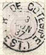
Sein Nachfolger BMG-0215b (Abb. aus dem Internet): ein Doppelkreis mit den Inschriften B. DO COTEGIPE oben und (MINAS) unten. Die Daten in der Mitte entstammen dem Zeitraum 1888-1897.

Categories
Carimbologia A-B

Barão de Camargos (train station/Bahnhof), Minas Gerais (BMG-0210)

Estado de Minas Geraes, 1910

Inaugurated in September 1885 by the E.F. Leopoldina Railway Company (Recreio Branch), Barão de Camargos station was located on the east bank of the Pomba River in the Município of Cataguazes, 210 km southeast of the provincial capital of Ouro Preto. From 1975 until its closure in 1996, the railway line belonged to Rede Ferroviária Federal S.A. (estacoesferroviarias.com.br). Today the rails are still there, but the station building has been demolished. The place is now host to a mining company that extracts bauxite.

ca. 2004 (Photo : Gutierrez Coelho, in estacoesferroviarias.com.br)

There were two barons of Camargos in imperial Brazil. The first was called Manuel Teixeira de Souza (1811-1878), he was a large landowner and senator. His son Antonio Teixeira de Souza Magalhães (1848-1912) studied medicine but became provincial president of Minas Gerais six times for a short period:

Antonio Teixeira de Souza Magalhães, 2nd Baron of Camargos

As the Rio press reported, there had been a post office at the station since January 1889:

Diario do Commercio/RJ, 01.02.1889

The postmark from the imperial period is BMG-0210a (image from the Internet): a double circle with the inscriptions BARÃO DE CAMARGOS above and (MINAS) below. The only specimen so far bears a date from 1890 in the centre.

Estrada de Ferro Leopoldina

Der Bahnhof Barão de Camargos wurde im September 1885 durch die E.F. Leopoldina Bahngesellschaft (Recreio-Abzweigung) eingeweiht und lag am Ostufer des Flusses Pomba im Município von Cataguazes, 210 km südöstlich der Provinzhauptstadt Ouro Preto entfernt. Von 1975 bis zur Stilllegung 1996 gehörte die Bahnstrecke der Rede Ferroviária Federal S.A. (estacoesferroviarias.com.br). Heute sind die Schienen noch da, aber das Bahnhofsgebäude wurde abgerissen. Der Ort ist nun Sitz einer Bergbaufirma, die Bauxit abbaut.

ca. 2004 (Foto : Gutierrez Coelho, in estacoesferroviarias.com.br)

Es gab zwei Baronen von Camargos im kaiserlichen Brasilien. Der erste hieß Manuel Teixeira de Souza (1811-1878), er war Großgrundbesitzer und Senator. Sein Sohn Antonio Teixeira de Souza Magalhães (1848-1912) hat zwar Medizin studiert, wurde aber sechsmal für jeweils kurze Zeit Provinzpräsident von Minas Gerais:

Antonio Teixeira de Souza Magalhães, 2. Baron von Camargos

Wie die Presse aus Rio berichtete, gab es ein Postamt am Bahnhof seit Januar 1889:

Diario do Commercio/RJ, 01.02.1889

Der Poststempel aus der Kaiserzeit ist BMG-0210a (Abb. aus dem Internet): ein Doppelkreis mit den Inschriften BARÃO DE CAMARGOS oben und (MINAS) unten. Das bisher einzige Exemplar trägt ein Datum aus 1890 in der Mitte.

Categories
Carimbologia A-B

Barão de Aquino (train station/Bahnhof), Rio de Janeiro (BRJ-0115)

Almanak Laemmert, 1892

The Barão de Aquino station was inaugurated in March 1889 by the E.F. Leopoldina Railway Company (Sumidouro Branch), close to the east bank of the Paquequer River in the Município of Carmo, 170 km northeast of the capital Rio de Janeiro. From June 1890, it was in the Município of Sumidouro. The railway line was closed in 1967, the rails were taken off and the station building is now used as a residence (estacoesferroviarias.com.br):

Ca. 2017 (Photo: Jaqueline Mentora, in estacoesferroviarias.com.br)

As reported by the Rio press, there had been a railway station post office there since March 1889:

Jornal do Commercio, 27/03/1889

The imperial postmark here is BRJ-0115a (image: Luis C. Fritzen): a double circle with the inscriptions BARÃO DE AQUINO above and (EST.) below. The dates in the centre so far go from 1889 to 1891.

Estrada de Ferro Leopoldina, 1898

Der Bahnhof Barão de Aquino wurde im März 1889 durch die E.F. Leopoldina Bahngesellschaft (Sumidouro-Abzweigung) eingeweiht und lag nah am Ostufer des Flusses Paquequer im Municipio von Carmo, 170 km nordöstlich der Hauptstadt Rio de Janeiro entfernt. Ab Juni 1890 lag er im Município von Sumidouro. Die Bahnlinie wurde 1967 stillgelegt, die Schienen wurden abgerissen, und das Bahnhofsgebäude dient heute als Wohnhaus (estacoesferroviarias.com.br):

Ca. 2017 (Foto: Jaqueline Mentora, in estacoesferroviarias.com.br)

Wie die Presse aus Rio berichtete, gab es dort ein Bahnhofspostamt seit März 1889:

Jornal do Commercio, 27.03.1889

Der kaiserliche Poststempel dazu ist BRJ-0115a (Abb. Luis C. Fritzen): ein Doppelkreis mit den Inschriften BARÃO DE AQUINO oben und (EST.) unten. Die Daten in der Mitte gehen bisher von 1889 bis 1891.

Categories
Carimbologia A-B

Banharão (train station/Bahnhof), São Paulo (BSP-0095)

Companhia Paulista

Text update on March 15, 2025

There were two railway stations in São Paulo called Banharão. This is the older one, inaugurated in February 1887 by the E.F. Rio Clarense Railway Company, Jaú Branch, and was then located on the north bank of the Tietê River in the Município of Dois Córregos, 270 km northwest of the capital São Paulo. The railway line changed to the Rio Claro Railway in 1888 and belonged to Companhia Paulista from 1892 until it was closed in 1941. Then a new line was built, which required a new station. The area around the old station, which had been demolished in the meantime, became part of the newly founded Município of Mineiros in August 1899, which has been called Mineiros do Tietê since November 1944.

Ca. 1919 (Photo: Filemon Pires, in estacoesferroviarias.com.br)

Philatelist Mário Celso Orsi Jr. writes that there was a station post office there from February 1887. However, a note from the regional press shows that the agency was created a month later:

Correio Paulistano, 18/03/1887

In the meantime, the postmark BSP-0095a (Fig. Felipe Piccinini) has been found, which should be the first from this station:

BSP-0095a (FP) 1888-1891

The successor BSP-0095b (coll. Alexandre Andrade) was found on a stamp from 1894:

BSP-0095b (AA) 1894ff
Google Maps

Textaktualisierung am 15. März 2025

Es gab zwei Bahnhöfe in São Paulo, die Banharão hießen. Dieser ist der Ältere, im Februar 1887 durch die E.F. Rio Clarense Bahngesellschaft, Jaú Abzweigung, eingeweiht, und lag damals am Nordufer des Flusses Tietê im Município von Dois Córregos, 270 km nordwestlich der Hauptstadt São Paulo entfernt. Die Bahnlinie wechselte 1888 zur Rio Claro Railway und gehörte von 1892 bis zur Stilllegung 1941 der Companhia Paulista. Dann kam eine Neubaustrecke für die Linie, die ein neuer Bahnhof erforderlich machte. Die Region um den inzwischen abgerissenen Altbahnhof ging im August 1899 zum neu gegründeten Município von Mineiros, der seit November 1944 Mineiros do Tietê heißt.

Ca. 1919 (Foto: Filemon Pires, in estacoesferroviarias.com.br)

Der Philatelist Mário Celso Orsi Jr. schreibt, dass es dort ab Februar 1887 ein Bahnhofspostamt gab. Eine Note der Regionalpresse zeigt allerdings, dass die Agentur ein Monat später entstanden ist:

Correio Paulistano, 18.03.1887

Inzwischen wurde der Poststempel BSP-0095a (Abb. Felipe Piccinini) gefunden, der der erste von diesem Bahnhof sein soll:

BSP-0095a (FP) 1888-1891

Auf einer Briefmarke von 1894 fand sich der Nachfolger BSP-0095b (Samml. Alexandre Andrade):

BSP-0095b (AA) 1894ff

Categories
Carimbologia A-B

Banco Verde (train station/Bahnhof), Minas Gerais (BMG-0205)

Estado de Minas Geraes, 1910

The Banco Verde (Green Bank) railway station was inaugurated in December 1884 by the E.F. Leopoldina railway company (Manhuassú line) and was located in the Município of Cataguazes, 260 km south-east of the provincial capital Ouro Preto. The railway line switched to Rede Ferroviária Federal S.A. in 1975 and was closed in 1979. Today, the rails are gone and the station is a ruin (estacoesferroviarias.com.br). Since December 1890, the station has been located in the Município of S. Francisco do Capivara, which has been called Palma since March 1891.

ca. 2003 (Photo : Wanderley Duck, in estacoesferroviarias.com.br)

Paula Sobrinho writes in História Postal de Minas Gerais (Belo Horizonte, 1997) that there was a station post office there since May 1885. This information is confirmed by the postal report (Relatorio Postal) for 1887. BMG-0205a is the first postmark, which was seen with dates from 1887 and 1888 and is also made known by R. Koester in Carimbologia III:

BMG-0205a (RK) 1887-1888

It was followed by BMG-0205b (image: Márcio Protzner) : a double circle with the inscriptions BANCO VERDE above and (EST.) below. The dates in the centre go from 1888 to 1901.

Instituto Brasileiro de Geografia e Estatística, 1958

Der Bahnhof Banco Verde (Grüne Bank) wurde im Dezember 1884 durch die E.F. Leopoldina Bahngesellschaft (Manhuassú-Linie) eingeweiht und lag im Município von Cataguazes, 260 km südöstlich der Provinzhauptstadt Ouro Preto entfernt. Die Bahnlinie wechselte 1975 zur Rede Ferroviária Federal S.A. und wurde 1979 stillgelegt. Heute sind die Schienen weg, und der Bahnhof ist eine Ruine (estacoesferroviarias.com.br). Seit Dezember 1890 liegt der Bahnhof im Município von S. Francisco do Capivara, der seit März 1891 Palma heißt.

ca. 2003 (Foto : Wanderley Duck, in estacoesferroviarias.com.br)

Paula Sobrinho schreibt in História Postal de Minas Gerais (Belo Horizonte, 1997), dass es dort seit Mai 1885 ein Bahnhofspostamt gab. Diese Angabe wird durch den Postbericht (Relatorio Postal) für 1887 bestätigt. BMG-0205a ist der erste Poststempel, der schon mit Daten aus 1887 und 1888 gesehen wurde und auch durch R. Koester in Carimbologia III bekannt ist:

BMG-0205a (RK) 1887-1888

Ihm folgte BMG-0205b (Abb. Márcio Protzner) : ein Doppelkreis mit den Inschriften BANCO VERDE oben und (EST.) unten. Daten in der Mitte von 1888 bis 1901.

Categories
Carimbologia A-B

Bananal, Rio de Janeiro (BRJ-0110)

Villiers de l’Ile Adam: Carta (…) da Provincia do Rio de Janeiro, 1850

The curato (a place with a chapel and a parish priest in charge) of N. Sa. da Conceição do Bananal was established in 1846, belonged to the Vila of Itaguaí and was located on the west bank of the Guandu River, 70 km west of the capital Rio de Janeiro. In August 1851, it became a freguesia, whose name has changed twice since then: in January 1924 to Padioba and in November 1926 to Seropédica. Since October 1995, Seropédica has been an independent município.

The local post office was created in April 1859, as Paulo Novaes writes in agenciaspostais.com.br, and is confirmed by the Rio press:

Correio Mercantil, 26.05.1859

The first postmark is BRJ-0110a and was already shown by R. Koester in Carimbologia III:

BRJ-0110a (RK) 1859ff

It was followed by BRJ-0110b (image from the internet): a double circle with the inscription BANANAL above and an ornament below, formed by two small circles, the outer side of each being open. One copy found, dated 1889 in the centre.

Atlas do Imperio do Brasil, 1868

Der Curato (ein Ort mit Kapelle und zuständigem Pfarrer) von N. Sa. da Conceição do Bananal entstand 1846, gehörte zur Vila von Itaguaí und lag am Westufer des Flusses Guandu, 70 km westlich der Hauptstadt Rio de Janeiro. Im August 1851 wurde daraus eine Freguesia, deren Name seitdem zweimal wechselte: im Januar 1924 zu Padioba und im November 1926 zu Seropédica. Seit Oktober 1995 ist Seropédica ein eigenständiger Município.

Das örtliche Postamt wurde im April 1859 ins Leben gerufen, wie Paulo Novaes in agenciaspostais.com.br schreibt, und durch die Presse aus Rio bestätigt wird:

Correio Mercantil, 26.05.1859

Der erste Poststempel ist BRJ-0110a und wurde bereits durch R. Koester in Carimbologia III gezeigt:

BRJ-0110a (RK) 1859ff

Ihm folgte BRJ-0110b (Abb. aus dem Internet): ein Doppelkreis mit der Inschrift BANANAL oben und einem Ornament unten, das aus zwei kleinen Kreisen gebildet wird, deren äußere Seite jeweils offen ist. Ein Exemplar gefunden, datiert 1889 in der Mitte.

Categories
Carimbologia A-B

Bananal (Povoação), Rio de Janeiro (BRJ-0111)

Almanak Laemmert 1892

Bananal (Banana Grove) was a small settlement belonging to the Freguesia of Guapy-Mirim, located on the north bank of the Bananal River, just before it flows into the Soberbo in the Município of Magé, 75 km north of the capital Rio de Janeiro. This village may have been an important stop on the way to the imperial city of Teresópolis. Since December 1990, Bananal has been a district in the Município of Guapimirim.

According to the Directory of Imperial Post Offices (Tabella das Agencias do Correio do Imperio, Rio de Janeiro, 1885), there was a post office there from 1880. The postal route to Teresópolis is also confirmed by the Almanak Laemmert:

Almanak Laemmert, 1881

However, the agency was already closed in April 1905, as Paulo Novaes reports in agenciaspostais.com.br. Apparently, there was a new route to the north, away from the village. The 19th century postmark is BRJ-0111a (Coll. FM) a double circle with the inscription P. DO BANANAL at the top. The only one seen so far has a date from 1899 in the centre.

agenciaspostais.com.br

Bananal (Bananenhain) war eine kleine Siedlung, die zur Freguesia von Guapy-Mirim gehörte und am Nordufer des Flusses Bananal lag, kurz vor dessen Mündung in den Soberbo im Município von Magé, 75 km nördlich der Hauptstadt Rio de Janeiro. Diese Ortschaft war möglicherweise eine wichtige Station auf dem Weg zur Kaiserstadt Teresópolis. Seit Dezember 1990 ist Bananal ein Ortsteil im Município von Guapimirim.

Wie aus dem Verzeichnis der kaiserlichen Postämter (Tabella das Agencias do Correio do Imperio, Rio de Janeiro, 1885) hervorgeht, gab es dort ein Postamt ab 1880. Die Postroute nach Teresópolis wird auch durch den Almanak Laemmert bestätigt:

Almanak Laemmert, 1881

Allerdings wurde die Agentur bereits im April 1905 geschlossen, wie Paulo Novaes in agenciaspostais.com.br berichtet. Offenbar gab es eine neue Route nach Norden, die abseits des Orts lag. Der Poststempel im 19. Jahrhundert ist BRJ-0111a (Samml. FM) ein Doppelkreis mit der Inschrift P. DO BANANAL oben. Das bisher einzig gesichtete Exemplar hat ein Datum aus 1899 in der Mitte.

Categories
Carimbologia A-B

Banabuyé, Paraíba (BPB-0044)

Atlas do Imperio do Brasil, 1868

Other names: Boa Esperança, Esperança (1908)

The beautiful Tupi word banabuyé means swamp of butterflies. The chapel of N. Sra. do Bom Conselho de Banabuyé was built in 1862 in the Município of Alagoa Nova, located 130 km west of the provincial capital Parahyba do Norte (today: João Pessoa). In 1872, it became a district called Boa Esperança and in May 1908 a freguesia, which was then simply called Esperança. Since December 1925, Esperança has been an independent município.

Three dates have been found for the creation of the local post office. First in June 1884, as stated in the postal report (Relatorio Postal) for 1887. Then in 1885, as reported in historiaesperancense.blogspot.com. Finally in May 1887, as Reinhold Koester (Carimbologia XVII) writes. However, the simultaneous existence of 2-3 place names seems to become a problem here. Even in 1889, when the place had long since been called Boa Esperança, it was still sporadically called Banabuyé by the regional press:

Gazeta do Sertão, 12.07.1889

So far, no imperial postmark has been seen from Banabuyé. Koester (op.cit.) shows a cancellation with Esperança, unfortunately without dates.

Sociedade Geologica e Mineralogica, 1910

Andere Namen: Boa Esperança, Esperança (1908)

Das schöne Tupi-Wort banabuyé bedeutet Sumpf der Schmetterlinge. Die Kapelle von N. Sra. do Bom Conselho de Banabuyé wurde 1862 im Município von Alagoa Nova errichtet, 130 km westlich der Provinzhauptstadt Parahyba do Norte (heute: João Pessoa) gelegen. 1872 wurde daraus ein Distrikt namens Boa Esperança und im Mai 1908 eine Freguesia, die dann nur Esperança hieß. Seit Dezember 1925 ist Esperança ein eigenständiger Município.

Für die Entstehung des örtlichen Postamts wurden drei Zeitpunkte gefunden. Ertmals im Juni 1884, wie im Postbericht (Relatorio Postal) für 1887 zu lesen ist. Dann 1885, wie im historiaesperancense.blogspot.com berichtet wird. Schließlich im Mai 1887, wie Reinhold Koester (Carimbologia XVII) schreibt. Allerdings scheint hier das gleichzeitige Vorhandensein von 2-3 Ortsnamen ein Problem zu werden. Noch 1889, als der Ort längst Boa Esperança hieß, wurde sein Postamt immer noch von der Regionalpresse Banabuyé genannt:

Gazeta do Sertão, 12.07.1889

Bisher wurde kein kaiserlicher Poststempel von Banabuyé gesehen. Koester (op.cit.) zeigt eine Entwertung mit Esperança, leider ohne Datumsangaben.

Categories
Carimbologia A-B

Bambuhy, Minas Gerais (BMG-0105)

Atlas do Imperio do Brasil, 1868

The Freguesia of Sant’Anna do Bambuhy was founded in Jnauar 1816 at the Vila of Formiga, located on the east bank of the river Bambuí, 350 km west of the provincial capital Ouro Preto. In September 1881, it became a vila in its own município, and since July 1886, the place has been a town, now spelt Bambuí.

Both Paul Sobrinho (História Postal de Minas Gerais, Belo Horizonte, 1997) and the postal report (Relatorio Postal) for 1887 write that there was a post office there from October 1881. However, the Rio press reported the corresponding decision a month earlier:

Jornal do Commercio/RJ, 30.09.1881

The earliest postmark so far is BMG-0105a (image: J. L. Pedreira): a double circle with the inscription BAMBUHY at the top. The dates in the middle are from the early Republic: 1890-1891.

Villiers de l’Ile Adam: Carta (…) da Provincia de Minas Geraes, 1849

Die Freguesia von Sant’Anna do Bambuhy wurde im Januar 1816 bei der Vila von Formiga gegründet und lag am Ostufer des Flusses Bambuí, 350 km westlich der Provinzhauptstadt Ouro Preto entfernt. Im September 1881 wurde daraus eine Vila im eigenen Município, und seit Juli 1886 ist der Ort eine Stadt, die sich inzwischen Bambuí schreibt.

Sowohl Paul Sobrinho (História Postal de Minas Gerais, Belo Horizonte, 1997) als auch der Postbericht (Relatorio Postal) für 1887 schreiben, dass es dort ab Oktober 1881 ein Postamt gab. Allerdings meldete die Rio-Presse bereits einen Monat früher die entsprechende Entscheidung:

Jornal do Commercio/RJ 30.09.1881

Der früheste Poststempel bisher ist BMG-0105a (Abb. J. L. Pedreira): ein Doppelkreis mit der Inschrift BAMBUHY oben. Die Daten in der Mitte kommen aus der frühen Republik: 1890-1891.

Categories
Carimbologia A-B

Balthazar (train station/Bahnhof), Rio de Janeiro (BRJ-0105)

Almanak Laemmert, 1892

Balthazar station was inaugurated in 1883 by E.F. Santo Antonio de Padua (Campos-Miracema line) and was located on the south bank of the Pomba River in the Município of Sto. Antonio de Pádua, 260 km northeast of the capital Rio de Janeiro. The railway line subsequently changed ownership three times: in 1884 to E.F. Macahe e Campos, in 1887 to E.F. Leopoldina, and from 1975 until its closure in 1996 it belonged to Rede Ferroviaria Federal S.A. (estacoesferroviarias.com.br). The settlement around the station continued to grow and was declared a district in March 1938. The station building was demolished in 2021, but the rails still lie.

Demolition of the station in 2021 (Photo: Júlio Alves, in estacoesferroviarias.com.br)

The establishment of a station post office was decreed in November 1882, according to the Rio press:

Gazeta de Noticias, 26/11/1882

The first postmark is BRJ-0105a and has already been presented by Paulo Novaes in agenciaspostais.com.br:

BRJ-0105a (PN) 1884

It was followed by BRJ-0105b (coll. Márcio Protzner), which can be seen in estacoesferroviarias.com.br:

BRJ-0105b (MP) 1887-1891

BRJ-0105c (image from the internet) should already be Republican, because its dates go from 1892 to 1900. It has the same inscriptions as BRJ-0105b, but the letters are now shorter.

Estrada de Ferro Leopoldina

Der Bahnhof Balthazar wurde 1883 durch die E.F. Santo Antonio de Padua (Linie Campos-Miracema) eingeweiht und lag am Südufer des Flusses Pomba im Município von Sto. Antonio de Pádua, 260 km nordöstlich der Hauptstadt Rio de Janeiro entfernt. Die Bahnlinie wechselte danach den Besitz dreimal: 1884 zur E.F. Macahe e Campos, 1887 zur E.F. Leopoldina, und von 1975 bis zur Stilllegung 1996 gehörte sie der Rede Ferroviaria Federal S.A. (estacoesferroviarias.com.br). Die Siedlung um den Bahnhof wuchs weiter und wurde im März 1938 zum Distrikt ernannt. Das Bahnhofsgebäude wurde 2021 abgerissen, aber die Schienen liegen noch.

Bahnhofabriss 2021 (Foto: Júlio Alves, in estacoesferroviarias.com.br)

Über die Einrichtung eines Bahnhofspostamts wurde im November 1882 verfügt, wie die Presse aus Rio mitteilte:

Gazeta de Noticias, 26.11.1882

Der erste Poststempel ist BRJ-0105a und wurde bereits durch Paulo Novaes in agenciaspostais.com.br bekannt gemacht:

BRJ-0105a (PN) 1884

Ihm folgte BRJ-0105b (Samml. Márcio Protzner), der in estacoesferroviarias.com.br zu sehen ist:

BRJ-0105b (MP) 1887-1891

BRJ-0105c (Abb. aus dem Internet) dürfte bereits republikanisch sein, denn seine Daten gehen von 1892 bis 1900. Er hat die gleichen Inschriften wie BRJ-0105b, die Buchstaben sind nun aber kürzer.