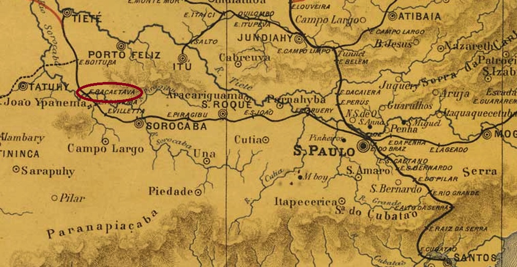
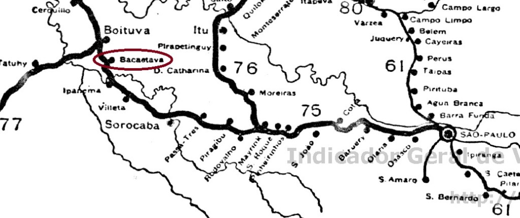
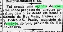
Bacaetava station was inaugurated in August 1880 by the E.F. Sorocabana Railway Company, Main Line, located in the Município of Porto Feliz, 130 km west of the provincial capital São Paulo. The railway line changed hands in 1892 to the Cia. União Sorocabana e Ytuana and from 1905 to 1928 it belonged to the E.F. Sorocabana e Ytuana. Then the station was deactivated, as the new company Sorocabana built a new railway line that relocated the station.
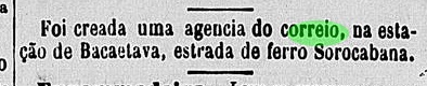
There was a station post office from August 1880 on, as reported by the regional press:
Jornal da Tarde, 01.09.1880
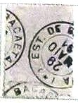
The imperial postmark BSP-0075a (image: F. Piccinini) is a French type:
BSP-0075a (FP) 1880ff-1891Cia. Sorocabana e Ytuana, 1898
Textaktualisierung am 2. Mai 2024
Der Bahnhof Bacaetava wurde im August 1880 durch die E.F. Sorocabana-Bahngesellschaft, Hauptlinie, eingeweiht und lag im Município von Porto Feliz, 130 km westich der Provinzhauptstadt São Paulo entfernt. Die Bahnlinie wechselte 1892 zur Cia. União Sorocabana e Ytuana und von 1905 bis 1928 gehörte sie der E.F. Sorocabana e Ytuana. Dann wurde der Bahnhof deaktiviert, da die neue Gesellschaft Sorocabana eine neue Bahntrasse baute, die den Bahnhof verlegt hat.
Ein Bahnhofspostamt gab es ab August 1880, wie die Regionalpresse meldete:
Jornal da Tarde, 01.09.1880
Der kaiserliche Poststempel BSP-0075a (Abb. Felipe Piccinini) ist ein französischer Typus:
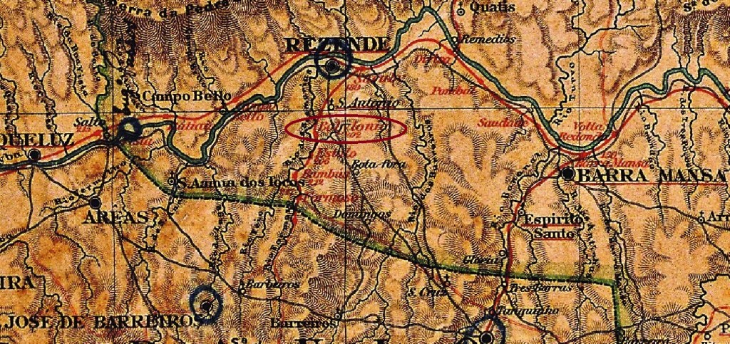
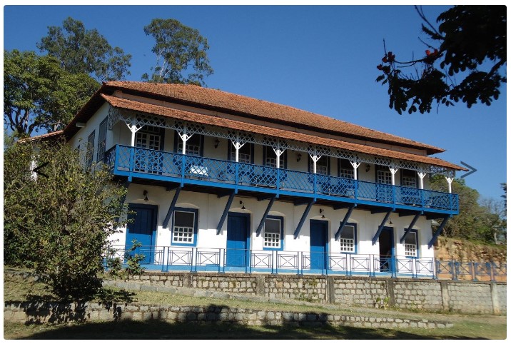
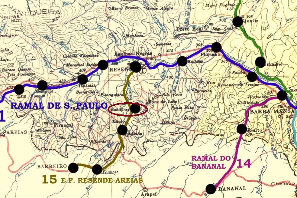
Babylonia station was inaugurated in November 1877 by the E.F. Resende a Bocaina Railway Company, Main Line, and was located near Resende, 180 km west of the capital Rio de Janeiro. The biblical name probably comes from an important fazenda in the area.
fazendasantigas.com
The railway line only remained in operation until the late 1920s, the rails are long gone, and the station building has been demolished.
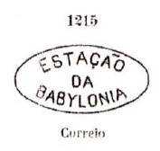
As Paulo Novaes writes in agenciaspostais.com.br, there was a station post office there since July 1878, active until December 1916. The first imperial postmark is BRJ-0100a, it has already been made known by Paulo Ayres in Catálogo de Carimbos Brasil-Imperio (S. Paulo 1937, 1942) under No. 1215.
P. A. 1215
After this came BRJ-0100b (coll. Fuad Ferreira Fo.): a double circle with the inscriptions BABYLONIA above and (ESTAÇÃO) below. The only specimen so far has a date of December 1889 in the centre.
agenciaspostais.com.br
Textaktualisierung am 17. Mai 2023
Der Bahnhof Babylonia wurde im November 1877 durch die E.F. Resende a Bocaina, Hauptlinie, eingeweiht und lag bei Resende, 180 km westlich der Hauptstadt Rio de Janeiro entfernt. Der biblische Name kommt wahrscheinlich von einer wichtigen Fazenda der Gegend.
fazendasantigas.com
Die Bahnlinie blieb nur bis Ende der 20er Jahre in Betrieb, die Schienen sind längst weg, und das Bahnhofsgebäude wurde abgerissen.
Wie Paulo Novaes in agenciaspostais.com.br schreibt, gab es dort ein Bahnhofspostamt seit Juli 1878, das bis Dezember 1916 aktiv war. Der erste kaiserliche Poststempel ist BRJ-0100a und wurde bereits durch Paulo Ayres in Catálogo de Carimbos Brasil-Imperio (S. Paulo 1937, 1942) unter Nr. 1215 bekannt gemacht.
P. A. 1215, 1878ff
Nach diesem kam BRJ-0100b (Samml. Fuad Ferreira Fo.): ein Doppelkreis mit den Inschriften BABYLONIA oben und (ESTAÇÃO) unten. Das bisher einzige Exemplar hat ein Datum aus Dezember 1889 in der Mitte.
Carta da Republica dos Estados Unidos do Brazil, 1892
See also Urussanga (USC-0270)
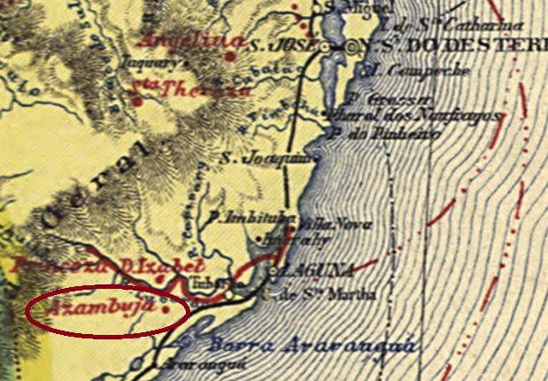
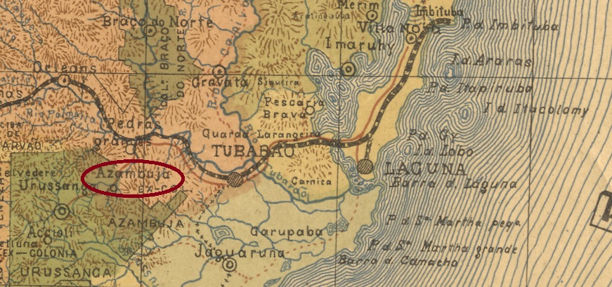
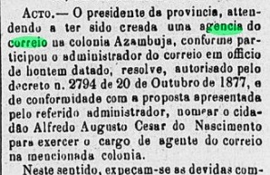
The Italian colony called S. Marcos de Azambuja was established in April 1877 in the Município of Tubarão, located barely 180 km south of the provincial capital of Desterro (today: Florianópolis). In January 1900, it became a district, which has belonged to the newly established Município of Pedras Grandes since December 1961.
The local post office was established in the early 1880s, according to the regional press:
O Despertador, 01.05.1880
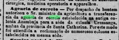
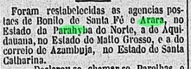
However, the agency was transferred to neighbouring Urussanga in September 1887, and it was not until February 1898 that the post office reopened in Azambuja.
Jornal do Commercio/RJ, 06.09.1887Gazeta de Noticias/RJ, 13.02.1898
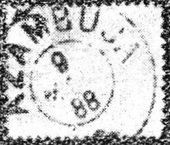
The imperial postmark is ASC-0010a and has already been made known by R. Koester (Carimbologia II):
ASC-0010a (RK) 1888-1890ff
Since all postmark dates are so far from the time after the postal transfer to Urussanga, it can be assumed that the Azambuja postmarks continued to be used there without any problems, for no imperial Urussanga postmark has been seen yet.
Estado de Santa Catharina, 1907
Siehe auch Urussanga (USC-0270)
Die italienische Kolonie namens S. Marcos de Azambuja entstand im April 1877 im Município von Tubarão und lag knapp 180 km südlich der Provinzhauptstadt Desterro (heute: Florianópolis). Im Januar 1900 wurde daraus ein Distrikt, der seit Dezember 1961 dem neu gegründeten Município von Pedras Grandes angehört.
Das örtliche Postamt entstand Anfang 1880, wie aus der Regionalpresse hervorgeht:
O Despertador, 01.05.1880
Die Agentur wurde allerdings im September 1887 zum benachbarten Urussanga verlegt, und erst im Februar 1898 eröffnete in Azambuja wieder die Post.
Jornal do Commercio/RJ, 06.09.1887Gazeta de Noticias/RJ, 13.02.1898
Der kaiserliche Poststempel ist ASC-0010a und wurde bereits durch R. Koester (Carimbologia II) bekannt gemacht:
ASC-0010a (RK) 1888-1890ff
Da die bisherigen Stempeldaten aus der Zeit nach der Postverlegung nach Urussanga stammen, ist es anzunehmen, dass man dort ohne Probleme die Azambuja-Stempel weiter verwendete, zumal bisher kein Urussanga-Stempel aus dem Kaiserreich zu sehen war.
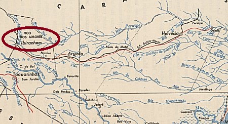
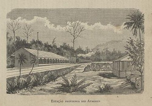
Aymorés station was inaugurated in November 1882 by the E.F. da Bahia a Minas and was located close to the east bank of the Pau Alto River in the Município of Mucury, 1020 km south of the provincial capital Salvador da Bahia. The railway line went to Chemins de Fer Fédéraux de l’Est Brésilien in 1912 and to E.F. Bahia-Minas Railway Company in 1936. From 1965 until its closure the following year, it belonged to V.F. Centro-Oeste (estacoesferroviarias.com.br). The name Aymorés recalls an Indian tribe of the border region between Bahia and Espirito Santo.
ca. 1883 (estacoesferroviarias.com.br)
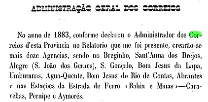
The station post office came into being in 1883, as the provincial postal administration’s report for 1884 announced:
Relatorio do Conselho Interino do Governo da Bahia, 1884
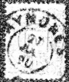
The imperial postmark is ABA-0090a, with dates from 1887 to 1890, already presented by R. Koester (Carimbologia II):
ABA-0090a (RK)
We know from Koester (op. cit.) about a handwritten cancellation from there:
1885 (RK)Instituto Brasileiro de Geografia e Estatística, 1958
Andere Namen : Aymorezinho, Ibiranhém
Der Bahnhof Aymorés wurde im November 1882 durch die E.F. da Bahia a Minas eingeweiht und lag nah am Ostufer des Flusses Pau Alto im Município von Mucury, 1020 km südlich der Provinzhauptstadt Salvador da Bahia. Die Bahnlinie ging 1912 zur Fa. Chemins de Fer Fédéraux de l’Est Brésilien und 1936 zu E.F. Bahia-Minas Bahngesellschaft. Von 1965 bis zur Stilllegung im folgenden Jahr gehörte sie der V.F. Centro-Oeste (estacoesferroviarias.com.br). Der Name Aymorés erinnert an einem Indianerstamm der Grenzregion zwischen Bahia und Espirito Santo.
ca. 1883 (estacoesferroviarias.com.br)
Das Bahnhofspostamt entstand 1883, wie der Bericht der provinziellen Postverwaltung für 1884 bekannt gab:
Relatorio do Conselho Interino do Governo da Bahia, 1884
Der kaiserliche Poststempel ist ABA-0090a, der mit Daten von 1887 bis 1890 versehen ist und bereits durch R. Koester (Carimbologia II) vorgestellt wurde:
ABA-0090a (RK)
Auch durch Koester (op. cit.) kennen wir eine handschriftliche Entwertung von dort:
Avellar (train station/Bahnhof), Rio de Janeiro (ARJ-0095)
Other names: Parada do Barão, Est. Boa Vista, Desvio da Boa Vista, Vieira Cortez (1924)
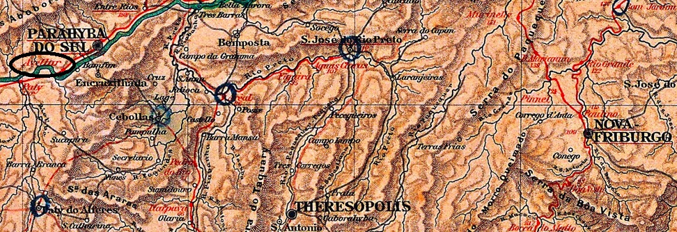
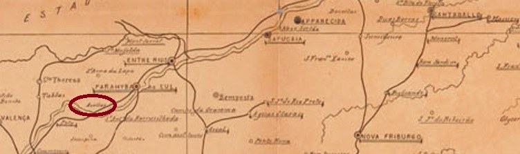
This station was inaugurated in July 1885 by the E.F. Dom Pedro II Railway Company in the Freguesia of S. Pedro and S. Paulo in the Município of Parahyba do Sul on the north bank of the river of the same name, 140 km north of the capital Rio de Janeiro. The railway line went to E.F. Central do Brasil in 1889, and from 1975 until its closure in 1996 it belonged to Rede Ferroviária Federal S.A. However, since 1924 the station was called Vieira Cortez (estacoesferroviarias.com.br), because another station called Avellar was inaugurated in March 1898, 30 km further south at Paty do Alferes. The name Avellar apparently comes from the Baron of Capivary, née Joaquim Ribeiro de Avellar (1791-1863), a large landowner of the region, while Vieira Cortez was an engineer of the E.F. Central do Brasil.
Joaquim R. de Avellar, 1st Baron of Capivary
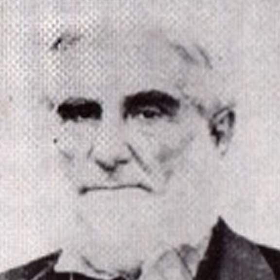
Today the rails are still there, but the station building no longer exists:
2002 (Photo Jorge A. Ferreira Jr, in estacoesferroviarias.com.br)
The station post office came into being in September 1884, according to the Rio press:
Gazeta da Tarde, 13/09/1884
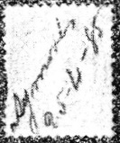
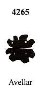
The imperial postmark is ARJ-0095a (image: agenciaspostais.com.br): a double circle with the inscription AVELLAR above and an ornament in flower below, reflected horizontally. The dates in the centre go from 1889 to 1896. From Mute Cancellations of the Brazil Empire/ Carimbos Mudos do Brasil Império (Brazil Philatelic Association, Rio de Janeiro, 2000) by James Dingler and Klerman W. Lopes there also comes a mute cancellation, with no. 4265:
BPA 4265Mappa Postal do Rio de Janeiro, 1906
Andere Namen: Parada do Barão, Est. Boa Vista, Desvio da Boa Vista, Vieira Cortez (1924)
Dieser Bahnhof wurde im Juli 1885 durch die E.F. Dom Pedro II Bahngesellschaft eingeweiht und lag in der Freguesia von S. Pedro und S. Paulo im Município von Parahyba do Sul am Nordufer des gleichnamigen Flusses, 140 km nördlich der Hauptstadt Rio de Janeiro entfernt. Die Bahnlinie ging 1889 zur E.F. Central do Brasil, von 1975 bis zur Stilllegung 1996 gehörte sie der Rede Ferroviária Federal S.A. Allerdings hieß der Bahnhof seit 1924 Vieira Cortez (estacoesferroviarias.com.br), denn ein anderer Bahnhof namens Avellar wurde im März 1898 30 km weiter südlich bei Paty do Alferes eingeweiht. Der Name Avellar kommt offenbar vom Baron von Capivary, geb. Joaquim Ribeiro de Avellar (1791-1863), einem Großgrundbesitzer der Region, während Vieira Cortez ein Ingenieur der E.F. Central do Brasil war.
Joaquim R. de Avellar, 1. Baron von Capivary
Heute sind die Schienen noch da, doch das Bahnhofsgebäude existiert nicht mehr:
2002 (Foto Jorge A. Ferreira Jr, in estacoesferroviarias.com.br)
Das Bahnhofspostamt wurde im September 1884 ins Leben gerufen, wie die Presse aus Rio mitteilte:
Gazeta da Tarde, 13.09.1884
Der kaiserliche Poststempel ist ARJ-0095a (Abb. agenciaspostais.com.br): ein Doppelkreis mit der Inschrift AVELLAR oben und einem Ornament in Blume unten, das sich horizontal spiegelt. Die Daten in der Mitte gehen von 1889 bis 1896. Aus Mute Cancellations of the Brazil Empire/ Carimbos Mudos do Brasil Império (Brazil Philatelic Association, Rio de Janeiro, 2000) von James Dingler und Klerman W. Lopes kommt auch eine stumme Entwertung, mit Nr. 4265:
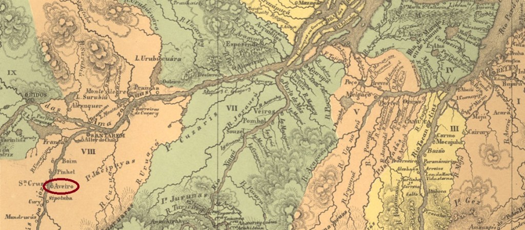
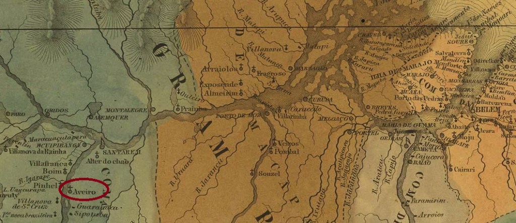
This place is said to have been a vila called N. Sra. da Conceição do Aveiro as early as 1781, located 800 km (as the crow flies) southwest of the later provincial capital Belém do Pará. However, today it still takes 1,300 km by car to get there. Vila status was lost in November 1848 when it was relegated as a freguesia in the Município of Itaituba, but returned in April 1883. In November 1930, it was again downgraded as a district – this time to the Município of Santarém. Aveiro has been an independent municipality again since December 1961. The name – like many other place names in Pará – is reminiscent of a Portuguese town.
As can be seen from the Directory of Imperial Post Offices (Tabella das Agencias do Correiodo Imperio, Rio de Janeiro, 1885), there had been a post office there since 1878. Since the agency was not listed either in the Imperial Postal Guide (Guia Postal do Império) from 1880 or in the Directory of Pará Post Offices from 1881, it can be assumed that it did not start operating until around 1883. So far, no imperial postmark from Aveiro has been seen.
Villiers de l’Ile Adam: Carta (…) das Provincias do Grão Pará e Alto Amazonas, 1850
Dieser Ort soll bereits 1781 eine Vila mit Namen N. Sra. da Conceição do Aveiro gewesen sein, die 800 km (Luftlinie) südwestlich der späteren Provinzhauptstadt Belém do Pará lag. Allerdings braucht man heute noch 1.300 km mit dem Auto zu fahren, um dorthin zu kommen. Der Vila-Status ging im November 1848 mit dem Abstieg als Freguesia im Município von Itaituba verloren, kehrte aber im April 1883 zurück. Im November 1930 erfolgte erneut eine Herabstufung als Distrikt – diesmal zum Município von Santarém. Seit Dezember 1961 ist Aveiro wieder eine eigenständige Gemeinde. Der Name – wie viele andere Ortsnamen in Pará – erinnert an eine portugiesische Stadt.
Wie aus dem Verzeichnis der kaiserlichen Postämter (Tabella das Agencias do Correio do Imperio, Rio de Janeiro, 1885) entnommen wird, gab es dort ein Postamt seit 1878. Da die Agentur weder im Kaiserlichen Postführer (Guia Postal do Império) aus 1880 noch im Verzeichnis der Pará-Postämter aus dem Jahr 1881 aufgelistet wurde, ist es anzunehmen, dass sie ihren Betrieb erst ca. 1883 aufnahm. Bisher war kein kaiserlicher Poststempel aus Aveiro zu sehen.
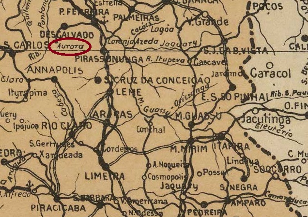
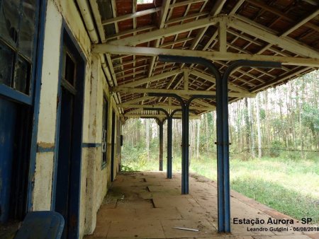
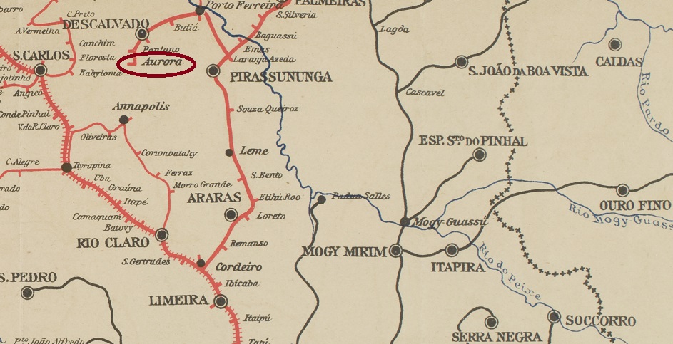
Aurora station was inaugurated in January 1889 by the E.F. Descalvadense railway company and was located south of the provincial town of Descalvado, 250 km northwest of the capital São Paulo. From 1891 until its closure in 1960, the line belonged to the Cia. Paulista de Estradas de Ferro. Today, the rails have been demolished and the station building serves as the office of an agricultural company. Aurora was the name of the wife of one of the landowners who built the railway line (estacoesferroviarias.com.br).
2018 (Photo: Leandro Ghidini, in estacoesferroviarias.com.br)
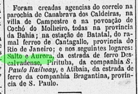
There had been a postal agency at the station since August 1889, according to the Rio press:
Gazeta de Noticias/RJ,05.08.1889
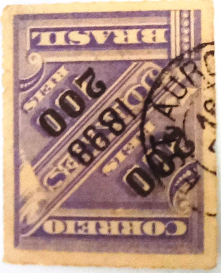
In the meantime, ASP-0072a has appeared in the Fuad Ferreira Fo. collection on a stamp of the year 1898:
ASP-0072a (FF) 1898ffCia. Paulista de Estradas de Ferro
Textaktualisierung am 20. August 2023
Der Bahnhof Aurora wurde im Januar 1889 durch die E.F. Descalvadense Bahngesellschaft eingeweiht und lag südlich des Provinzstädtchens Descalvado, 250 km nordwestlich der Hauptstadt São Paulo entfernt. Von 1891 bis zur Stilllegung 1960 gehörte die Strecke der Cia. Paulista de Estradas de Ferro. Heute sind die Schienen abgerissen, das Bahnhofsgebäude dient als Büro eines Landwirtschaftsbetriebs. Aurora hieß die Ehefrau eines der Großgrundbesitzer, die die Bahnlinie legen ließen (estacoesferroviarias.com.br).
2018 (Foto: Leandro Ghidini, in estacoesferroviarias.com.br)
Am Bahnhof gab es eine Postagentur seit August 1889, wie die Presse aus Rio mitteilte:
Gazeta de Noticias/RJ,05.08.1889
Inzwischen ist ASP-0072a in der Sammlung Fuad Ferreira Fo. auf einer Marke des Jahres 1898 aufgetaucht:
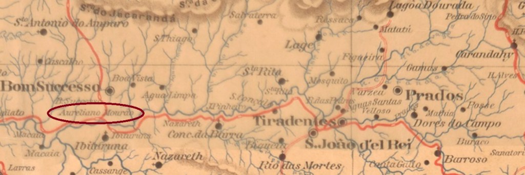
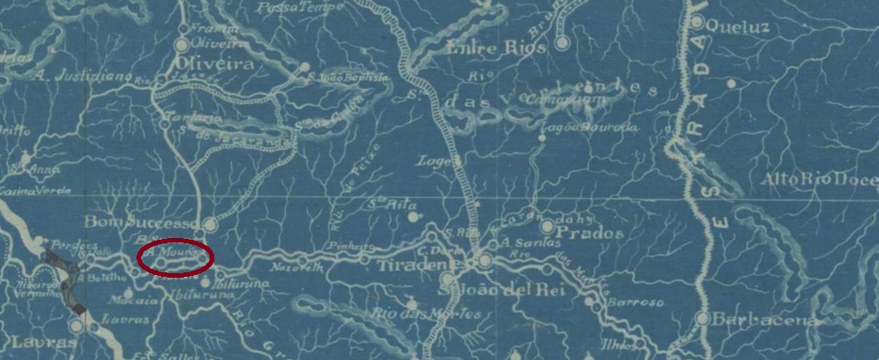
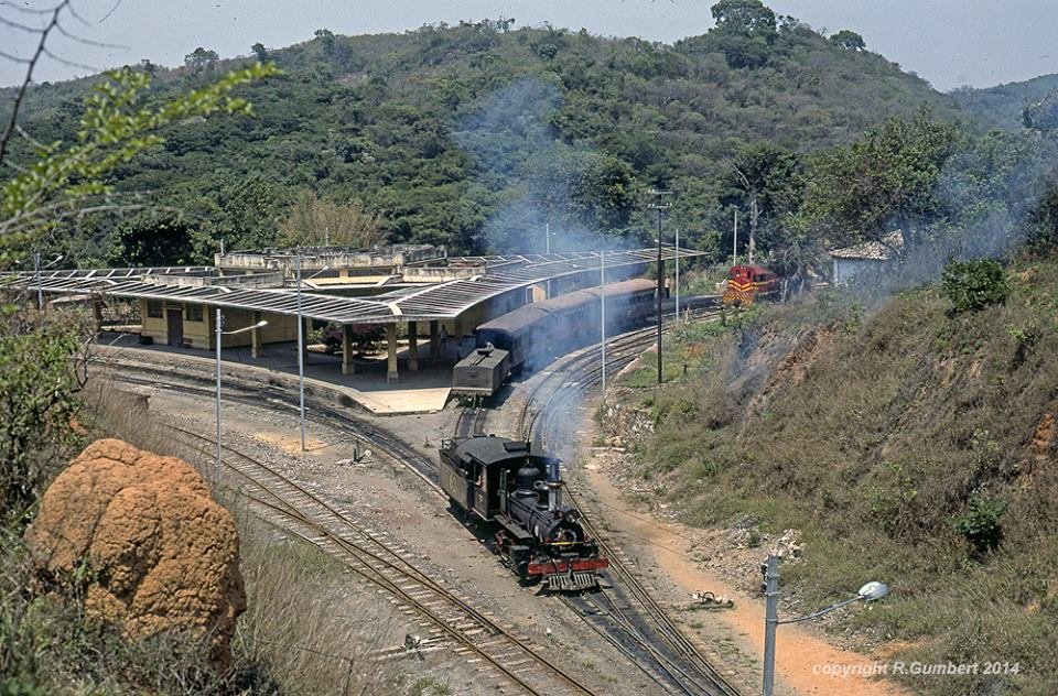
Aureliano Mourão station was inaugurated in October 1887 by the E.F. Oeste de Minas railway company (Paraopeba Line) and was located on the north bank of the Rio das Mortes in the Município of Bom Successo, 240 km southwest of the provincial capital Ouro Preto. The railway line was transferred to Rede Mineira de Viação in 1931 and to V.F. Centro-Oeste in 1965. From 1975 until its closure in 1979, it belonged to Rede Ferroviária Federal S.A. (estacoesferroviarias.com.br). Today, the rails have been removed and the station building is abandoned. The name is meant to commemorate Aureliano Marins de Carvalho Mourão, the first president of the E.F. Oeste de Minas.
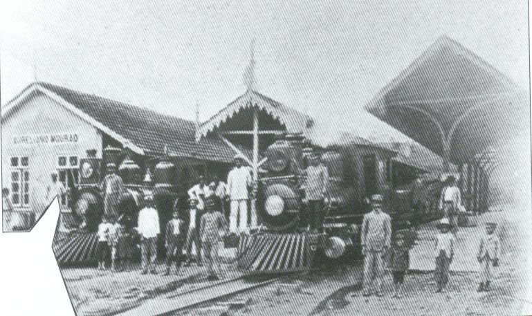
ca. 1912 (estacoesferroviarias.com.br)ca. 1980, Photo by R. Gumbert (estacoesferroviarias.com.br)
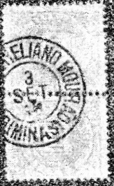
As Paula Sobrinho writes in História Postal de Minas Gerais (Belo Horizonte, 1997), there was a post office at the station from December 1887. The first postmark AMG-0160a was already made known by R. Koester in Carimbologia II.
AMG-0160a (RK) 1887ffE.F. Oeste de Minas, 1917
Der Bahnhof Aureliano Mourão wurde im Oktober 1887 durch die E.F. Oeste de Minas Bahngesellschaft (Paraopeba-Linie) eingeweiht und lag am Nordufer des Rio das Mortes im Município von Bom Successo, 240 km südwestlich der Provinzhauptstadt Ouro Preto entfernt. Die Bahnlinie ging 1931 zur Rede Mineira de Viação und 1965 zur V.F. Centro-Oeste über. Von 1975 bis zur Stilllegung 1979 gehörte sie der Rede Ferroviária Federal S.A. (estacoesferroviarias.com.br). Heute sind die Schienen bereits enftfernt worden, das Bahnhofsgebäude ist verlassen. Der Name soll an Aureliano Marins de Carvalho Mourão erinnern, den ersten Präsidenten der E.F. Oeste de Minas.
ca. 1912 (estacoesferroviarias.com.br)ca. 1980, Foto R. Gumbert (estacoesferroviarias.com.br)
Wie Paula Sobrinho in História Postal de Minas Gerais (Belo Horizonte, 1997) schreibt, gab es am Bahnhof ein Postamt ab Dezember 1887. Der erste Poststempel AMG-0160a wurde bereits durch R. Koester in Carimbologia II bekannt gemacht.
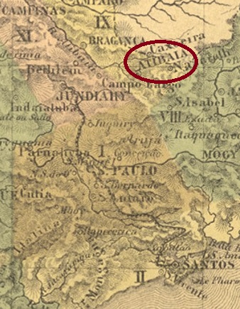
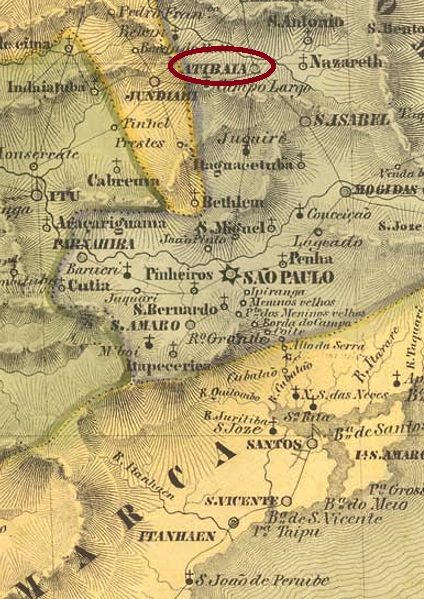
The freguesia of S. João Baptista de Atibaia was founded in August 1747 on the south bank of the river Atibaia, barely 70 km north of the vila of São Paulo. The village rose to the status of vila in June 1769 and to town in April 1864.
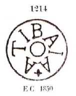
The local post office was established in January 1848, as Nova Monteiro writes in Administrações e Agencias Postaes do Brasil Imperio (Brasil Filatelico/RJ, 1934-5; Reprint SPP 1994-1999). However, this would be a reopening, as the first postmark ASP-0070a was already sighted on letters of the pre-philatelic period, as noted in the Catálogo Enciclopédico RHM (S. Paulo, 1999). The cancel is known by Paulo Ayres (Catálogo de Carimbos Brasil-Império, S. Paulo, 1937, 1942) under no. 1214:
ASP-0070a (RHM P-SP-1843, P.A. 1214) 1843ff
It was followed by two postmarks as double circles, which are very similar to each other, as both have only the inscription ATIBAIA at the top. On the earlier ASP-0070b (Image: Mario Celso Orsi Jr.) the letters are somewhat larger or thicker. It was seen with an internal date from 1878. The later ASP-0070c (Image by Luis C. Fritzen) has slimmer and smaller letters, with inner dates between 1885 and 1896.
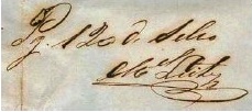
A station of the E.F. Bragantina railway company (Piracaia Line) was inaugurated there in August 1884, operated until 1967 and had its own post office from August 1889 (Boletim Postal 5/89). No postmark of this station has yet appeared. Instead, we can show two handwritten cancellations (image by Mário Celso Orsi Jr.):
1858 (MO)1877 (MO)illiers de l’Ile Adam: Carta (…) da Provincia de São Paulo, 1847
Die Freguesia von S. João Baptista de Atibaia entstand im August 1747 und lag am Südufer des Flusses Atibaia, knapp 70 km nördlich der Vila von São Paulo. Der Ort stieg im Juni 1769 zur Vila und im April 1864 zur Stadt auf.
Das örtliche Postamt wurde im Januar 1848 ins Leben gerufen, wie Nova Monteiro in Administrações e Agencias Postaes do Brasil Imperio (Brasil Filatelico/RJ, 1934-5; Reprint SPP 1994-1999) schreibt. Das dürfte allerdings eine Wiedereröffnung sein, da der erste Poststempel ASP-0070a schon auf Briefen der vorphilatelistischen Zeit gesichtet wurde, wie im Catálogo Enciclopédico RHM (S. Paulo, 1999) vermerkt. Der Stempel ist bekannt durch Paulo Ayres (Catálogo de Carimbos Brasil-Império, S. Paulo, 1937, 1942) unter Nr. 1214:
ASP-0070a (RHM P-SP-1843, P.A. 1214) 1843ff
Ihm folgten zwei Poststempel als Doppelkreise, die untereinander sehr ähnlich sind, da beide nur die Inschrift ATIBAIA oben tragen. Bei dem früheren ASP-0070b (Samml. Mario Celso Orsi Jr.) sind die Buchstaben etwas größer bzw. dicker. Gesichtet mit Datum aus 1878. Der spätere ASP-0070c (Samml. Luis C. Fritzen) hat schlankere und kleinere Buchstaben, mit inneren Daten zwischen 1885 und 1896.
Im August 1884 wurde dort ein Bahnhof der E.F. Bragantina Bahngesellschaft (Piracaia-Linie) eingeweiht, der bis 1967 betrieben wurde und ein eigenes Postamt ab August 1889 hatte (Boletim Postal 5/89). Noch ist kein Poststempel dieses Bahnhofs aufgetaucht. Dafür können wir zwei handschriftliche Entwertungen (Abb. Mário Celso Orsi Jr.) zeigen:
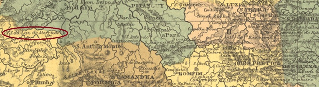
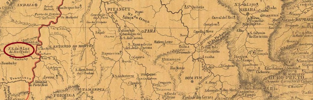
The Freguesia of N. Sra. da Luz do Aterrado was founded in May 1856 in the Município of Dores do Indayá, 290 km west of the provincial capital of Ouro Preto. Since September 1923, it has been a town in its own município, simply called Luz (Light).
Ther was a local post office since July 1884, as Paula Sobrinho writes in História Postal de Minas Gerais (Belo Horizonte, 1997). The oldest postmark so far is AMG-0155b (Coll. FM): a double circle with the inscriptions ATERRADO above and (MINAS) below. The only specimen so far bears a date from 1907 in the centre.
Provincia de Minas Gerais, 1873
Anderer Name: Luz (1923)
Die Freguesia von N. Sra. da Luz do Aterrado wurde im Mai 1856 im Município von Dores do Indayá gegründet und lag 290 km westlich der Provinzhauptstadt Ouro Preto entfernt. Seit September 1923 ist der Ort eine Stadt im eigenem Município, die einfach Luz (Licht) heißt.
Dort gab es ein Postamt seit Juli 1884, wie Paula Sobrinho in História Postal de Minas Gerais (Belo Horizonte, 1997) schreibt. Der bisher älteste Poststempel ist AMG-0155b (Samml. FM): ein Doppelkreis mit den Inschriften ATERRADO oben und (MINAS) unten. Das einzige Exemplar trägt ein Datum aus 1907 in der Mitte.