Categories
Carimbologia A-B

Aldeia, Bahia (ABA-0045)

Atlas do Imperio do Brasil, 1868

Text updated on July 24, 2024

Another name: Aratuhype (1890)

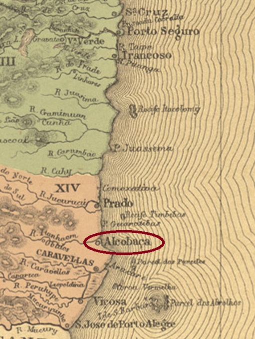
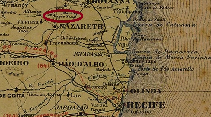
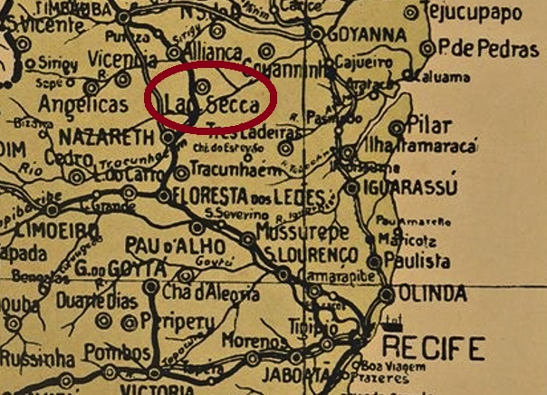
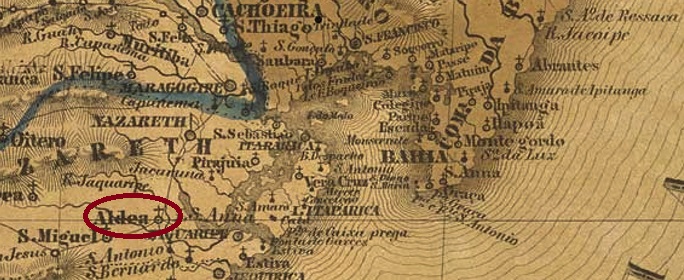
The Freguesia of Sant’Anna da Aldeia was founded in June 1840 in the Municipio of Nazareth, located on the north bank of the river Aratuípe, more than 80 km west of the provincial capital Salvador da Bahia. The place was elevated to the status of Vila of Aratuhype in February 1890 and to a town in June 1891. However, in December 1943, it was downgraded to the district of Nazaré (as it is now written), but immediately in June 1944, it regained the status of a Município, this time written Aratuípe. The term from the Tupi-Guarani language means river of the aratus. Aratu is a general term for various crab species commonly found in the region, such as Aratus pisonii:

Aratus pisonii (Photo: Tanaré Sevi, CC-BY-SA 3.0)

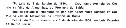
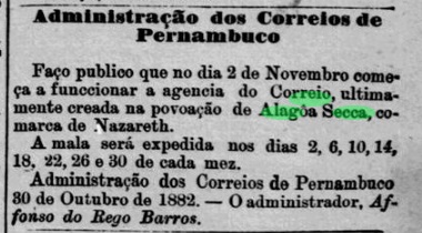
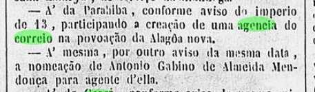
There are two dates of origin for the local post office. The first was in July 1882, according to the Rio press:

Gazeta de Noticias/RJ, 03.08.1882

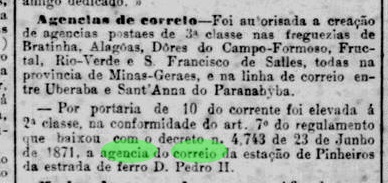
The same newspaper reported a reopening of the post office in August 1885:

Gazeta de Noticias/RJ, 15.08.1885

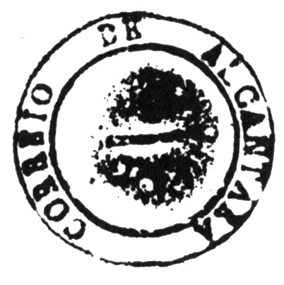
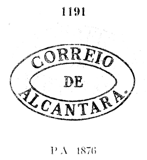
A postmark was found for the Empire: ABA-0045a (image from the internet) is a plain double circle with the inscription ALDEIA at the top, though there might be another ornament at the bottom. The dates in the centre so far come from 1886 to at least 1890.

Villiers de l’Ile Adam: Carta (…) da Provincia da Bahia, 1848

Text am 24.07.2024 aktualisiert

Anderer Name: Aratuhype (1890)

Die Freguesia von Sant’Anna da Aldeia wurde im Juni 1840 im Municipio von Nazareth gegründet und lag am Nordufer des Flusses Aratuípe, über 80 km westlich der Provinzhauptstadt Salvador da Bahia entfernt. Der Ort wurde im Februar 1890 zur Vila von Aratuhype und im Juni 1891 zur Stadt erhoben. Allerdings kam im Dezember 1943 eine Herabstufung zum Distrikt von Nazaré (wie man inzwischen schreibt), doch gleich im Juni 1944 wurde wieder der Status eines Município erreicht, diesmal Aratuípe geschrieben. Der Begriff aus der Tupi-Guarani-Sprache bedeutet Fluss der Aratus. Aratu ist ein Allgemeinbegriff für diverse Krebssorte, die in der Region häufig zu finden sind, wie z.B. Aratus pisonii:

Aratus pisonii (Foto: Tanaré Sevi, CC-BY-SA 3.0)

Es sind zwei Entstehungstermine fürs örtliche Postamt überliefert. Erstmals im Juli 1882, wie aus der Presse von Rio hervorgeht:

Gazeta de Noticias/RJ, 03.08.1882

Die gleiche Zeitung meldete im August 1885 eine Wiedereröffnung des Postamts:

Gazeta de Noticias/RJ, 15.08.1885

Ein Poststempel wurde fürs Kaiserreich gefunden: ABA-0045a (Abb. aus dem Internet) ist ein schlichter Doppelkreis mit der Inschrift ALDEIA oben, wobei unten evtl. ein weiters Ornament vorhanden wäre. Die Daten in der Mitte gehen von 1886 bis 1890ff.

Categories
Carimbologia A-B

Alcobaça, Bahia (ABA-0040)

Atlas do Imperio do Brasil, 1868

Another name: Itanhem

The settlement of Alcobaça was founded around 1750 by Portuguese, who supposedly have come from the town of the same name in Portugal, and was located on the north bank of the mouth of the river Itanhem, over 800 km south of the later provincial capital of Salvador da Bahia. The place became a vila in March 1755 and a town in July 1896.

The local post office is said to have been established by a decree of February 1859, as Nova Monteiro writes in Administrações e Agencias Postaes do Brasil Imperio (Brasil Filatelico/RJ, 1934-5; Reprint SPP 1994-1999). A postmark was found for the 19th century, unfortunately not the oldest. ABA-0040b (illustration from the internet) is a plain double circle with the inscription ALCOBAÇA at the top. The dates in the middle have so far been found for the period 1890-1893.

Villiers de l’Ile Adam: Carta (…) da Provincia da Bahia, 1848

Anderer Name: Itanhem

Die Siedlung Alcobaça wurde um 1750 durch Portugieser gegründet, die angeblich aus der gleichnamigen Stadt in Portugal stammen, und lag am Nordufer der Mündung des Flusses Itanhem, über 800 km südlich der späteren Provinzhauptstadt Salvador da Bahia entfernt. Der Ort wurde im März 1755 eine Vila und im Juli 1896 eine Stadt.

Das örtliche Postamt soll durch einen Erlass vom Februar 1859 entstanden sein, wie Nova Monteiro in Administrações e Agencias Postaes do Brasil Imperio (Brasil Filatelico/RJ, 1934-5; Reprint SPP 1994-1999) schreibt. Ein Poststempel wurde fürs 19. Jahrhundert gefunden, leider nicht der älteste. ABA-0040b (Abb. aus dem Internet) ist ein schlichter Doppelkreis mit der Inschrift ALCOBAÇA oben. Die Daten in der Mitte wurden bisher für den Zeitraum 1890-1893 gefunden.

Categories
Carimbologia A-B

Alcantara, Maranhão (AMA-0005)

Villiers de l’Ile Adam: Carta (…) da Provincia do Maranhão, 1850

Another name: Tapuitapera

The now sleepy town of Alcantara is at least 400 years old. The settlement existed as early as 1612, was called Tapuitapera (Indian home in Tupi-guarani) and was located about 40 km air-line northwest of the later provincial capital São Luís do Maranhão.  At that time, it was colonised by the French, but they were driven out by the Portuguese in about 1617. In March 1624, Tapuitapera even became the capital of the short-lived Capitania of Cumã. After the end of the Dutch occupation (1641-1644), the town was assigned to the Capitania of Maranhão and in December 1648 it became the Vila of Alcantara. Alcantara has been a town since July 1836.

The local post office was created in November 1829, as Nova Monteiro writes in Administrações e Agencias Postaes do Brasil Imperio (Brasil Filatelico/RJ, 1934-5; Reprint SPP 1994-1999). Two postmarks have been found so far for the 19th century. AMA-0005a is already known as no. 382 in  Cícero Antonio Almeida’s Carimbos Postais – século XIX (Rio de Janeiro, 1989) and was probably used in pre-philatelic times, until at least 1845:

AMA-0005a (MPT 382)

It was followed by AMA-0005b, used from about 1850 to at least 1876 and already presented by Paulo Ayres in Catálogo de Carimbos Brasil-Império (S. Paulo, 1937, 1942) with no. 1191:

AMA-0005b (P.A. 1191)
Atlas do Imperio do Brasil, 1868

Anderer Name: Tapuitapera

Das heute verschlafene Städtchen Alcantara ist mindestens 400 Jahre alt. Die Siedlung existierte bereits 1612, hieß Tapuitapera (Indianerheimat in Tupi-guarani) und lag ca. 40 km Lufllinie nordwestlich der späteren Provinzhauptstadt São Luís do Maranhão.  Damals wurde sie von Franzosen kolonisiert, die aber ca. 1617 von den Portugiesen vertrieben wurden. Im März 1624 wurde Tapuitapera sogar die Hauptstadt der kurzlebigen Capitania von Cumã. Nach dem Ende der holländischen Besatzung (1641-1644) wurde der Ort der Capitania von Maranhão zugeordnet und im Dezember 1648 wurde daraus die Vila von Alcantara. Seit Juli 1836 ist Alcantara eine Stadt.

Das örtliche Postamt entstand im November 1829, wie Nova Monteiro im Administrações e Agencias Postaes do Brasil Imperio (Brasil Filatelico/RJ, 1934-5; Reprint SPP 1994-1999) schreibt. Zwei Poststempel wurden bisher für das 19. Jahrhundert gefunden. AMA-0005a kennen wir bereits als Nr. 382 im Cícero Antonio Almeidas Carimbos Postais – século XIX (Rio de Janeiro, 1989) und ist vermutlich aus vorphilatelistischen Zeiten. Verwendet mindestens bis 1845:

AMA-0005a (MPT 382)

Ihm folgte AMA-0005b, der von ca. 1850 bis mindestens 1876 im Umlauf war und bereits durch Paulo Ayres in Catálogo de Carimbos Brasil-Império (S. Paulo, 1937, 1942) mit Nr. 1191 bereits vorgestellt wurde:

AMA-0005b (P.A. 1191)
Categories
Carimbologia A-B

Alcantara (train station/Bahnhof), Rio de Janeiro (ARJ-0010)

Almanak Laemmert, 1892

Other names: Lampadosa, Pedro de Alcantara (ca. 1953)

Alcantara station was inaugurated in 1874 by the Cia. Ferro-Carril Niterioense Railway Company in the Município of Niterói, 35 km northeast of Rio de Janeiro. The railway line changed hands in 1880 to E.F. Macahe e Campos, in 1887 to E.F. Leopoldina and from 1975 until its closure in 1996 it belonged to Rede Ferroviaria Federal S.A. (estacoesferroviarias.com.br). Since 1890, the station has been in the Município of São Gonçalo and afterwards its name has changed twice: around 1947 to Lampadosa and around 1953 to Pedro de Alcantara. Today the rails are gone, the station building is in ruins, but supposedly still inhabited.

In 2009: Photo Cleiton Pieruccini (estacoesferroviarias.com.br)

The station post office was also created in 1874 and began operating on 13 April.

Jornal do Commercio, 12.04.1874

So far, no postmark of the imperial period could be assigned with certainty to this station.

agenciaspostais.com.br

Andere Namen: Lampadosa, Pedro de Alcantara (ca. 1953)

Der Bahnhof Alcantara wurde 1874 durch die Cia. Ferro-Carril Niterioense Bahngesellschaft eingeweiht und lag damals im Município von Niterói, 35 km nordöstlich vin Rio de Janeiro entfernt. Die Bahnlinie wechselte 1880 zur E.F. Macahe e Campos, 1887 zur E.F. Leopoldina und von 1975 bis zur Stilllegung 1996 gehörte sie der Rede Ferroviaria Federal S.A. (estacoesferroviarias.com.br). Seit 1890 liegt der Bahnhof im Município von São Gonçalo und seitdem wechselte sein Name zweimal: ca. 1947 zu Lampadosa und ca. 1953 zu Pedro de Alcantara. Heut sind die Schienen weg, das Bahnhofsgebäude ist eine Ruine, aber angeblich noch bewohnt.

2009: Foto Cleiton Pieruccini (estacoesferroviarias.com.br)

Das Bahnhofspostamt entstand ebenfalls 1874, sein Betrieb wurde am 13. April d.J. aufgenommen.

Jornal do Commercio, 12.04.1874

Bisher konnte kein Poststempel der Kaiserzeit diesem Bahnhof mit Sicherheit zugeordnet werden.

Categories
Carimbologia A-B

Albuquerque, Mato Grosso (AMT-0005)

Atlas do Imperio do Brasil, 1868

The Arraial of N. Sra. da Conceição de Albuquerque was founded in 1778 by royal decree (Alvará Real) and was located on the west bank of the Paraguai River, over 900 km southwest of the later provincial capital of Cuiabá. The town rose to freguesia status in April 1838 and to vila status in July 1850 but was destroyed during the war against Paraguay (1864-1870). In November 1869, it became a district of Cuiabá and in October 1871 a vila, but it could not grow any further. In November 1878, Albuquerque became a suburb – later a district – of the newly established city of Corumbá, which lies a good 60 km further north. The name probably comes from Luis Albuquerque de Melo Pereira e Cáceres (1739-1797), who was Capitão-Mor of Mato Grosso from 1772 to 1788.

Three dates of origin for the local post office have been found. Firstly before 1854, according to the 1858 report of the General Postal Directory (Diretoria Geral dos Correios). Then in October 1858, as Nova Monteiro writes in Administrações e Agencias Postaes do Brasil Imperio (Brasil Filatelico/RJ, 1934-5; Reprint SPP 1994-1999). And finally, in 1861, as stated in the Directory of Imperial Post Offices (Tabella das Agencias do Correio do Imperio, Rio de Janeiro, 1885).

So far, no imperial postmark has been found with this place name.

Villiers de l’Ile Adam: Carta (…) da Provincia de Matto Grosso, 1850

Der Arraial von N. Sra. da Conceição de Albuquerque wurde 1778 durch königliche Verfügung (Alvará Real) gegründet und lag am Westufer des Flusses Paraguai, über 900 km südwestlich der späteren Provinzhauptstadt Cuiabá entfernt. Der Ort stieg im April 1838 zur Freguesia und im Juli 1850 zur Vila, wurde aber während des Kriegs gegen Paraguay (1864-1870) zerstört. Im November 1869 wurde daraus ein Distrikt von Cuiabá und im Oktober 1871 eine Vila, die aber nicht weiter wachsen konnte. Im November 1878 wurde aus Albuquerque ein Vorort – später ein Distrikt – der neu errichtete Stadt Corumbá, die gut 60 km weiter nördlich liegt. Der Name kommt wohl von Luis Albuquerque de Melo Pereira e Cáceres (1739-1797), der Capitão-Mor von Mato Grosso von 1772 bis 1788 war.

Drei Entstehungsdaten fürs örtliche Postamt wurden gefunden. Erstmals vor 1854, wie aus dem Bericht der Allgemeinen Postdirektion (Diretoria Geral dos Correios) aus 1858 hervorgeht. Dann im Oktober 1858, wie Nova Monteiro in Administrações e Agencias Postaes do Brasil Imperio (Brasil Filatelico/RJ, 1934-5; Reprint SPP 1994-1999) schreibt. Und schließlich 1861, wie im Verzeichnis der kaiserlichen Postämter (Tabella das Agencias do Correio do Imperio, Rio de Janeiro, 1885) zu lesen ist.

Bisher wurde kein Poststempel im Kaiserreich mit diesem Ortsnamen gefunden.

Categories
Carimbologia A-B

Alagoinhas, Pernambuco (APE-0030)

Carta Corographica da Provincia de Pernambuco, 1880

Another name: Alagoinha

The settlement called N. Sra. da Conceição de Alagoinhas originated around 1833, belonged to the Vila of Brejo da Madre de Deus and was located 230 km west of the provincial capital Recife. In May 1879, the village changed as a Freguesia to the Município of Cimbres (now Pesqueira) and since December 1948 it has been the Município of Alagoinha.

The local post office came into being in 1876, as the Directory of Imperial Post Offices (Tabella das Agencias do Correio do Imperio, Rio de Janeiro, 1885) and the Postal Report (Relatorio Postal) for 1887 agree. The imperial postmark is the French Type APE-0030a (Coll. Marco Morel): a double circle with the upper inscription ALAGOINHAS and the star between brackets at the bottom. The dates in the centre were seen so far for the period ca. 1885-1895.

Carta da Republica do Estdos Unidos do Brazil, 1892

Anderer Name: Alagoinha

Die Siedlung namens N. Sra. da Conceição de Alagoinhas entstand um 1833, gehörte der Vila von Brejo da Madre de Deus und lag 230 km westlich der Provinzhauptstadt Recife entfernt. Im Mai 1879 wechselte der Ort als Freguesia zum Município von Cimbres (heute Pesqueira) und ist seit Dezember 1948 der Município von Alagoinha.

Das örtliche Postamt entstand 1876, wie übereinstimmend das Verzeichnis der kaiserlichen Postämter (Tabella das Agencias do Correio do Imperio, Rio de Janeiro, 1885) und der Postbericht (Relatorio Postal) für 1887 vermerkten. Der kaiserliche Poststempel ist der Französische Typus APE-0030a (Samml. Marco Morel): ein Doppelkreis mit der oberen Inschrift ALAGOINHAS und dem Stern zwischen Klammern unten. Die bisher gesehenen Exemplare wurden ca. 1885-1895 verwendet.

Categories
Carimbologia A-B

Alagoinhas, Bahia (ABA-0035)

Villiers de l’Ile Adam: Carta (…) da Provincia da Bahia, 1848

The Freguesia of Santo Antonio de Alagoinhas was founded in November 1816 in the Vila of Inhambupe, close to the north bank of the Catu River, 120 km north of the future provincial capital Salvador da Bahia. It rose to the status of vila in June 1852 and town in July 1880.

Both Nova Monteiro (Administrações e Agencias Postaes do Brasil Imperio, in Brasil Filatelico/RJ, 1934-5; Reprint SPP 1994-1999) and Aureo G. Santos (Agências de Correio Criadas e Suprimidas 1851, 1855, 1856 e 1857, in Brasil Filatélico 181, Rio de Janeiro, 1977) agree that there was a post office there from January 1856:

Aureo G. Santos (op. cit.)

The only postmark of the imperial period so far is ABA-0035b (Coll. Luis C. Fritzen): a plain double circle with the upper inscription ALAGOINHAS. The dates in the middle were found for the period 1877ff and 1892.

Atlas do Imperio do Brasil, 1868

Die Freguesia von Santo Antonio de Alagoinhas wurde im November 1816 in der Vila von Inhambupe gegründet und lag nah am Nordufer des Flusses Catu, 120 km nördlich der späteren Provinzhauptstadt Salvador da Bahia entfernt. Im Juni 1852 stieg der Ort zur Vila und im Juli 1880 zur Stadt auf.

Sowohl Nova Monteiro (Administrações e Agencias Postaes do Brasil Imperio, in Brasil Filatelico/RJ, 1934-5; Reprint SPP 1994-1999) als auch Aureo G. Santos (Agências de Correio Criadas e Suprimidas 1851, 1855, 1856 e 1857, in Brasil Filatélico 181, Rio de Janeiro, 1977) sind sich darüber einig, dass es dort seit Januar 1856 ein Postamt gab:

Aureo G. Santos (op. cit.)

Der bisher einzige Poststempel der Kaiserzeit ist ABA-0035b (Samml. Luis C. Fritzen): ein einfacher Doppelkreis mit der oberen Inschrift ALAGOINHAS. Die Daten in der Mitte wurden für den Zeitraum 1877ff und 1892 gefunden.

Categories
Carimbologia A-B

Alagoas, Minas Gerais (AMG-0055)

Estado de Minas Geraes, 1910

Another name: Conceição das Alagoas (1938)

The Freguesia of N. Sra. da Conceição das Alagoas was founded in October 1878 in the Município of Uberaba, located on the south bank of the Uberaba River, 620 km west of the provincial capital of Ouro Preto. Since December 1938, the town has been the Município of Conceição das Alagoas.

The local post office was established in January 1882, according to the Rio press:

Jornal do Commercio/RJ, 11.01.1882

Paula Sobrinho writes a date of February 1882 for this in História Postal de Minas Gerais (Belo Horizonte, 1997), but this is probably a transcription error. So far, no imperial postmark has been seen from this locality.

Arthur D. Ribeiro: Mappa do Estado de São Paulo, 1924

Anderer Name: Conceição das Alagoas (1938)

Die Freguesia von N. Sra. da Conceição das Alagoas wurde im Oktober 1878 im Município von Uberaba gegründet und lag am Südufer des Flusses Uberaba, 620 km westlich der Provinzhauptstadt Ouro Preto entfernt. Seit Dezember 1938 ist der Ort der Município von Conceição das Alagoas.

Das örtliche Postamt wurde im Januar 1882 ins Leben gerufen, wie und die Presse aus Rio mitteilt:

Jornal do Commercio/RJ, 11.01.1882

Paula Sobrinho schreibt dafür in História Postal de Minas Gerais (Belo Horizonte, 1997) ein Datum aus Februar 1882, aber das dürfte ein Abschreibfehler sein. Bisher wurde kein kaiserlicher Poststempel aus dieser Ortschaft gesehen.

Categories
Carimbologia A-B

Alagoa Secca, Pernambuco (APE-0025)

Carta Corographica da Provincia de Pernnambuco, 1880

Other names: Lagoa Seca, Upatininga (1938)

The Freguesia of N. Sa. do Bom Despacho da Alagoa Secca (Our Lady of the Good Dispatch on the Dry Lake) was created in June 1883 in the Vila of Nazareth, 70 km northwest of the provincial capital Recife. In September 1928, the place – now called Lagoa Seca – changed to the Município of Aliança and received the place name Upatininga in December 1938. The term from the Tupi language also means Dry Lake.

The local post office started operations in November 1882, as reported in the regional press:

Jornal de Recife, 31.10.1882

The oldest postmark from the imperial period so far is APE-0025a (Coll. Márcio Protzner): A double circle with the inscriptions ALAGOA SECCA at the top and (PERNAMo) at the bottom. The only specimen seen has a date from 1894 in the centre.

Arthur D. Ribeiro: Mappa do Estado de Pernambuco, 1924

Andere Namen: Lagoa Seca, Upatininga (1938)

Die Freguesia von N. Sa. do Bom Despacho da Alagoa Secca (Unsere Liebe Frau des Guten Entschlusses am Trockenen See) entstand im Juni 1883 in der Vila von Nazareth, 70 km nordwestlich der Provinzhauptstadt Recife. Im September 1928 wechselte der Ort – nun Lagoa Seca genannt – zum Município von Aliança und bekam im Dezember 1938 den Ortsnamen Upatininga. Der Begriff aus der Tupi-Sprache bedeutet ebenfalls Trockenen See.

Das örtliche Postamt startete den Betrieb im November 1882, wie die Regionalpresse berichtete:

Jornal de Recife, 31.10.1882

Der bisher älteste Poststempel aus der Kaiserzeit ist APE-0025a (Samml. Márcio Protzner): Ein Doppelkreis mit den Inschriften ALAGOA SECCA oben und (PERNAMo) unten. Das einzig gesehene Exemplar hat ein Datum aus 1894 in der Mitte.

Categories
Carimbologia A-B

Alagoa Nova, Paraiba (APB-0015)

Villiers de l’Ile Adam: Carta (…) das Provincias do Rio Grande do Norte e Parahiba, 1848

Another name: Larangeiras (1938-1943)

The Freguesia of Sant’Anna da Alagoa Nova (St. Anne on the New Lake) was founded in February 1837 in the Município of Vila Nova da Rainha (now Campina Grande), 120 km west of the provincial capital of Parahiba do Norte (now João Pessoa). The village rose to a vila in September 1850 but was demoted as a district of Campina Grande in June 1900, only to rise again as a município in November 1904. Between 1938 and 1943 it was given the name Larangeiras before the old name returned.

Nova Monteiro writes in Administrações e Agencias Postaes do Brasil Imperio (Brasil Filatelico/RJ, 1934-5; Reprint SPP 1994-1999), there was a post office there since May 1850.

Confirmation of this is provided by the Rio press:

Diario do Rio de Janeiro, 13 June 1850 (Exped. 16 May)

So far, no imperial postmark from there has turned up.

Atlas do Imperio do Brasil, 1868

Anderer Name: Larangeiras (1938-1943)

Die Freguesia von Sant’Anna da Alagoa Nova (Hl. Anna am Neuen See) wurde im Februar 1837 im Município von Vila Nova da Rainha (heute Campina Grande) gegründet und lag 120 km westlich der Provinzhauptstadt Parahiba do Norte (heute João Pessoa) entfernt. Der Ort stieg zwar im September 1850 zur Vila, wurde aber im Juni 1900 als Distrikt von Campina Grande degradiert, um im November 1904 wieder als Município aufzusteigen. Zwischen 1938 und 1943 wurde ihm der Name Larangeiras verpasst, bevor der alte Name zurückkam.

Nova Monteiro schreibt in Administrações e Agencias Postaes do Brasil Imperio (Brasil Filatelico/RJ, 1934-5; Reprint SPP 1994-1999), es gab dort ein Postamt seit Mai 1850.

Die Bestätigung hierfür liefert die Presse aus Rio:

Diario do Rio de Janeiro, 13. Juni 1850 (Exped. 16.Mai)

Bisher ist aber kein kaiserlicher Poststempel von dort aufgetaucht.