Categories
Carimbologia A-B

Alagoa Grande, Paraiba (APB-0010)

Atlas do Imperio do Brasil, 1868

Text update on November 8, 2022

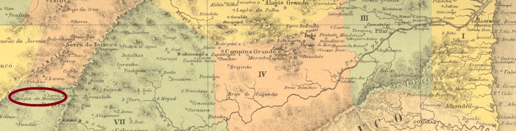
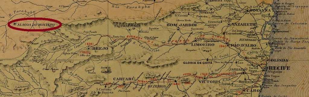
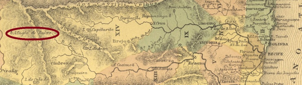
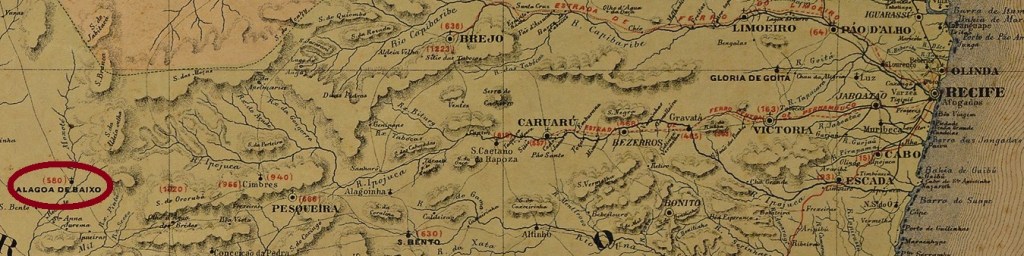
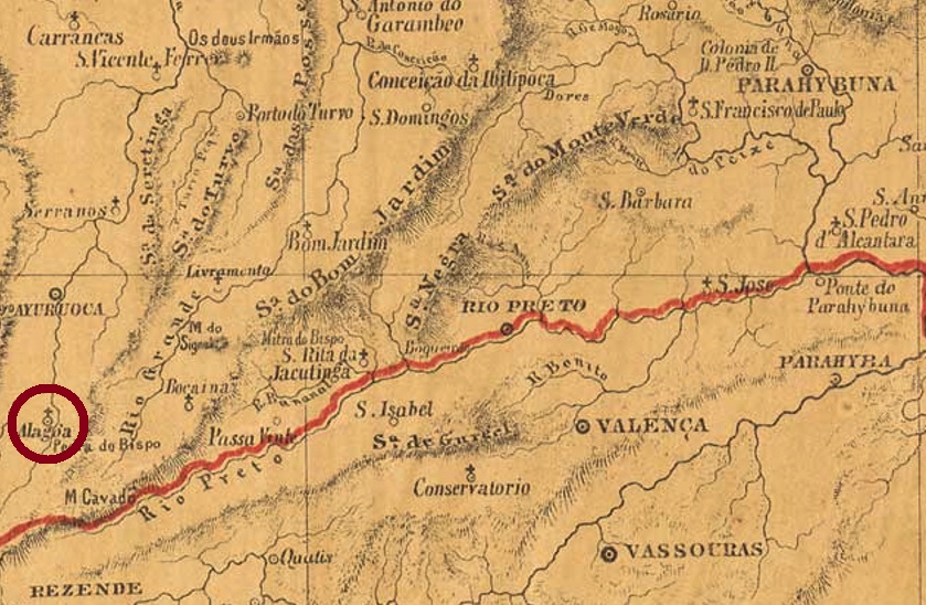
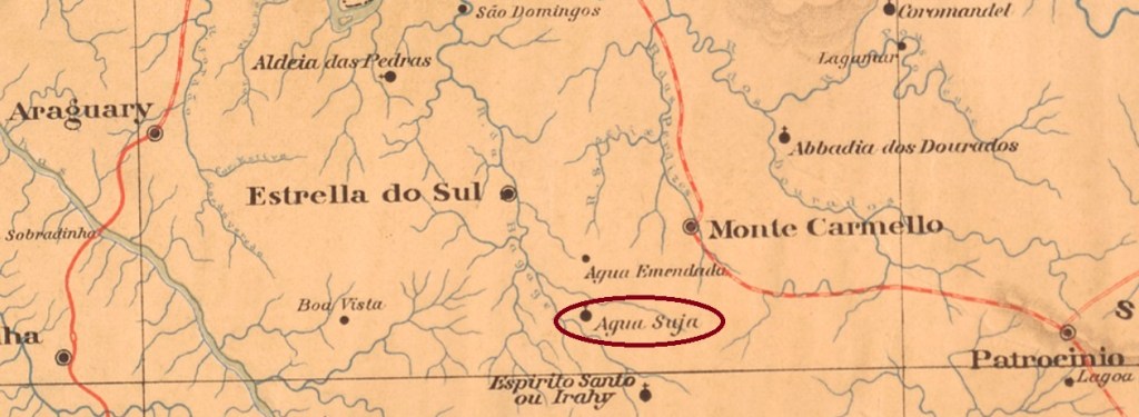
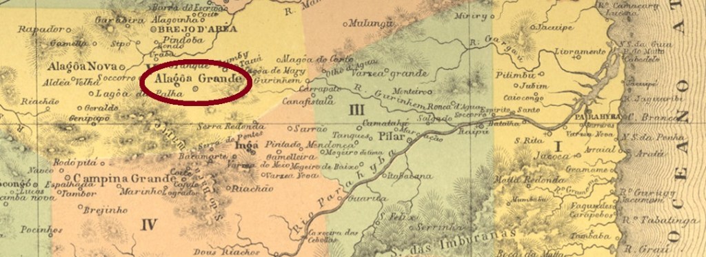
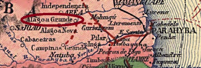
The freguesia called N. Sra. da Boa Viagem da Alagoa Grande (Our Lady of the Good Voyage on the Great Lake) was founded in October 1861 at the Vila of Areia, located on the south bank of the Mamanguape River, 100 km west of the provincial capital Parahiba do Norte (now João Pessoa). It became a vila in October 1865 and a town in March 1908.

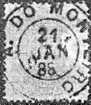
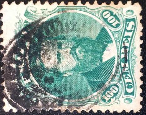
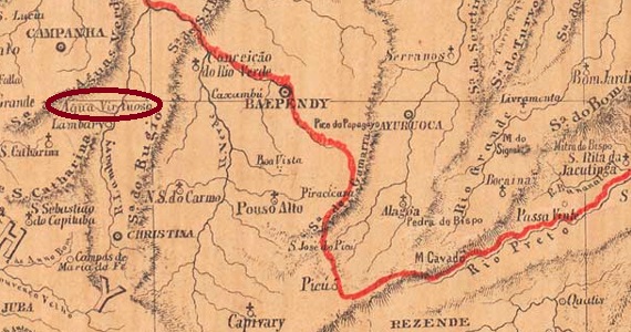
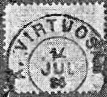
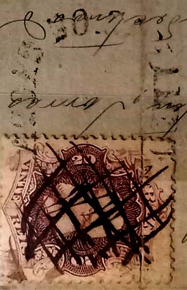
The local post office was established in March 1868, as Nova Monteiro writes in Administrações e Agencias Postaes do Brasil Imperio (Brasil Filatelico/RJ, 1934-5; Reprint SPP 1994-1999). So far, two turn-of-the-century postmarks from this locality have been seen, but unfortunately not the oldest one. APB-0010b (Image: RHM) could not yet be definitively confirmed because the only specimen – a plain double circle from 1891 – bears the inscription A(… ) GRANDE at the top and could thus also be from Arroio Grande/RS. APB-0010c (Image: RHM) is probably Republican. In this double circle the inscription above reads ALAGOA GRANDE, below one reads (PARAH. DO NORTE). One copy known, dated 1907 in the centre.

Carta da Republica dos Estados Unidos do Brazil, 1892

Textaktualisierung vom 8. November 2022

Die Freguesia namens N. Sra. da Boa Viagem da Alagoa Grande (Unsere Liebe Frau der Guten Reise am Großen See) wurde im Oktober 1861 bei der Vila von Areia gegründet und lag am Südufer des Flusses Mamanguape, 100 km westlich der Provinzhauptstadt Parahiba do Norte (heute João Pessoa) entfernt. Der Ort wurde im Oktober 1865 eine Vila und im März 1908 eine Stadt.

Das örtliche Postamt entdtand im März 1868, wie Nova Monteiro in Administrações e Agencias Postaes do Brasil Imperio (Brasil Filatelico/RJ, 1934-5; Reprint SPP 1994-1999) schreibt. Bisher waren zwei Poststempel der Jahrhundertwende aus dieser Ortschaft zu sehen, aber leider nicht der älteste. APB-0010b (Abb. RHM) konnte noch nicht endgültig bestätigt werden, denn das einzige Exemplar – ein schlichter Doppelkreis aus 1891 – trägt die Inschrift A(… ) GRANDE oben und könnte dadurch auch aus Arroio Grande/RS sein. APB-0010c (Abb. RHM) ist wohl republikanisch. In diesem Doppelkreis lautet die obige Inschrift ALAGOA GRANDE, unten liest man (PARAH. DO NORTE). Ein Exemplar bekannt, datiert 1907 in der Mitte.

Categories
Carimbologia A-B

Alagoa do Monteiro, Paraíba (APB-0005)

Atlas do Imperio do Brasil, 1868

Another name: Monteiro (1938)

The freguesia of N. Sa. das Dores da Alagoa do Monteiro (Our Lady of Sorrows on Lake Monteiro) came into being in September 1865 in the município of S. João do Cariri and was located on the south bank of the Monteiro River, 300 km southwest of the provincial capital of Parahyba do Norte (now João Pessoa). In May 1862, the village rose to a villa; since November 1938, Monteiro has been an independent município. The name commemorates Manoel Monteiro do Nascimento, the first large landowner in the region, no relative of mine.

As the postal report for 1887 states, the local post office came into being in September 1873. The only postmark so far is APB-0005a, as shown by R. Koester in Carimbologia I (1961):

APB-0005a (RK) 1888
Carta Corographica da Provincia de Pernambuco, 1880

Anderer Name: Monteiro (1938)

Die Freguesia von N. Sa. das Dores da Alagoa do Monteiro (Unsere Liebe Frau der Schmerzen am Monteirosee – nicht mit mir verwandt) entstand im September 1865 im Município von S. João do Cariri und lag am Südufer des Flusses Monteiro, 300 km südwestlich der Provinzhauptstadt Parahyba do Norte (heute João Pessoa) entfernt. Im Mai 1862 stieg der Ort zur Villa auf, seit November 1938 ist Monteiro ein eigenständiger Município. Der Name erinnert an Manoel Monteiro do Nascimento, den ersten Großgrundbesitzer der Region.

Wie der Postbericht (Relatorio Postal) für 1887 schreibt, entstand das örtliche Postamt im September 1873. Der bisher einzige Poststempel ist APB-0005a, wie von R. Koester in Carimbologia I (1961) gezeigt wurde:

APB-0005a (RK) 1888

Categories
Carimbologia A-B

Alagoa de Baixo, Pernambuco (APE-0020)

Atlas do Imperio do Brasil, 1868

Another name: Sertânia (1943)

The freguesia called N. Sa. da Conceição da Alagoa de Baixo (Our Lady of the Immaculate Conception on the Lower Lake) has existed since May 1842, it was located near the villa of Cimbres on the Moxotó River, 300 km west of the provincial capital Recife. In May 1873, the village rose to the status of a villa, and in July 1909 it became a town, which has had the name Sertânia since December 1943.

The local post office started operations in December 1875, as reported by the regional press:

Diario de Pernambuco, 14/12/1875

The imperial postmark is the French type APE-0020a (Coll. Marco Morel): a double circle with the inscription ALAGOA DE BAIXO above and the typical star between brackets below. There are two specimens sighted so far without date, both used on the 1885 numeral issue.

Carta Corographica da Provincia de Pernambuco, 1880

Anderer Name: Sertânia (1943)

Die Freguesia namens N. Sa. da Conceição da Alagoa de Baixo (Unsere Liebe Frau des Unbefleckten Empfängnis am Unteren See) gibt es seit Mai 1842, sie lag bei der Villa von Cimbres am Fluss Moxotó, 300 km westlich der Provinzhauptstadt Recife entfernt. Im Mai 1873 stieg die Ortschaft zur Villa und im Juli 1909 zu einer Stadt auf, die seit Dezember 1943 den Namen Sertânia trägt.

Das örtliche Postamt startete den Betrieb im Dezember 1875, wie die Regionalpresse berichtete:

Diario de Pernambuco, 14.12.1875

Der kaiserliche Poststempel ist der Französische Typ APE-0020a (Samml. Marco Morel): ein Doppelkreis mit der Inschrift ALAGOA DE BAIXO oben und dem typischen Stern zwischen Klammern unten. Es sind zwei bisher gesichtete Exemplare ohne Datum, beide auf der Ziffernausgabe aus 1885.

Categories
Carimbologia A-B

Alagoa de Ayuruoca, Minas Gerais (AMG-0060)

Atlas do Imperio do Brasil, 1868

Another name: Alagoa

The freguesia of N. Sa. do Rosario da Alagoa was founded in May 1855 at Aiuruoca, on the west bank of the river of the same name, close to the Serra do Papagaio, more than 300 km southwest of the provincial capital Ouro Preto. In September 1923, the town changed as a district of Itanhandu, and in December 1938 as a district to Itamonte. Since December 1962, Alagoa has been an independent Município.

The local post office was established in June 1887, according to the Rio press:

Diario de Noticias/RJ, 02.06.1887

So far, no postmark from the imperial period has been seen.

Provincia de Minas Geraes, 1873

Anderer Name: Alagoa

Die Freguesia von N. Sa. do Rosario da Alagoa wurde im Mai 1855 bei Aiuruoca gegründet und lag am Westufer des gleichnamigen Flusses nah an der Serra do Papagaio, über 300 km südwestlich der Provinzhauptstadt Ouro Preto entfernt. Im September 1923 wechselte der Ort als Distrikt von Itanhandu, und im Dezember 1938 als Distrikt zu Itamonte. Seit Dezember 1962 ist Alagoa ein eigenständiger Município.

Das örtliche Postamt entstand im Juni 1887, wie die Presse aus Rio mitteilte:

Diario de Noticias/RJ, 02.06.1887

Bisher war kein Poststempel aus der Kaiserzeit zu sehen.

Categories
Carimbologia A-B

Aguas Virtuosas, Minas Gerais (AMG-0050)

Atlas do Imperio do Brasil, 1868

Another name: Lambari

The Freguesia of Aguas Virtuosas de Campanha was founded in June 1850 in the Município of Campanha, located on the west bank of the river Lambari, 340 km southwest of the provincial capital Ouro Preto. In September 1901, the village emancipated itself as an independent município, which has been called Lambari since December 1930. Lambari is the indigenous general term for nearly 150 fish species of the genus Astyanax (Characidae family), which are found from Patagonia to Arizona in the Americas.

Astyanax anterior (Eigenmann, 1908, CC BY SA 4.0)

Paula Sobrinho writes in Historia Postal de Minas Gerais (Belo Horizonte, 1997) that the local post office was created in August 1859. This is confirmed by a ministerial protocol from Rio:

Expediente do Ministerio da Agricultura, 22.08.1859

The oldest postmark so far, AMG-0040a (Coll. Lelio Cimini), is unfortunately not yet clearly visible in detail:

AMG-0050a (LC) 1866ff

It was followed by AMG-0040b, which was already shown by R. Koester (Carimbologia I):

AMG-0040b (RK) 1886

Then came AMG-0040c (image from the internet), which was in circulation from 1887 to at least 1891: a double circle with the inscription AGUAS VIRTUOSAS at the top and an ornament in lozenge at the bottom, cross-cut in the middle.

Provincia de Minas Geraes, 1873

Anderer Name: Lambari

Die Freguesia von Aguas Virtuosas de Campanha wurde im Juni 1850 im Município von Campanha gegründet und lag am Westufer des Flusses Lambari, 340 km südwestlich der Provinzhauptstadt Ouro Preto entfernt. Im September 1901 emanzipiert sich der Ort als eigenständiger Município, der seit Dezember 1930 Lambari heißt. Lambari ist der indigene Allgemeinbegriff für knapp 150 Fische der Gattung Astyanax (Familie Characidae), die von Patagonien bis Arizona im amerikanischen Kontinent zu finden sind.

Astyanax anterior (Eigenmann, 1908, CC BY SA 4.0)

Paula Sobrinho schreibt in Historia Postal de Minas Gerais (Belo Horizonte, 1997), dass das örtliche Postamt im August 1859 ins Leben gerufen wurde. Das wird durch ein Ministerialprotokoll aus Rio bestätigt:

Expediente do Ministerio da Agricultura, 22.08.1859

Der bisher älteste Poststempel AMG-0040a (Samml. Lelio Cimini) ist leider bisher nicht ganz deutlich in Detail zu sehen:

AMG-0050a (Lelio Cimini) 1866ff

Ihm folgte AMG-0040b, der bereits durch R. Koester (Carimbologia I) gezeigt wurde:

AMG-0040b (RK) 1886

Danach kam AMG-0040c (Abb. aus dem Internet), der von 1887 bis mindestens 1891 im Umlauf war: ein Doppelkreis mit der Inschrift AGUAS VIRTUOSAS oben und einem Ornament in Raute unten, das in der Mitte kreuzförmig offen ist.

Categories
Carimbologia A-B

Aguas do Caxambu, Minas Gerais (AMG-0040)

Provincia de Minas Geraes, 1873

Another name: Caxambu

The beautiful word Caxambu comes from the Tupi-Guarani and is said to mean forest sounds. The freguesia of N. Sra. dos Remédios de Caxambu was founded in November 1844 in the Município of Baependy, 300 km southwest of the provincial capital Ouro Preto. In November 1875, the town’s name changed to Santa Maria das Águas de Caxambu. Since September 1901, Caxambu has been an independent município.

As Paula Sobrinho writes in História Postal de Minas Gerais (Belo Horizonte, 1997), there was a post office there since December 1871. The first postmark AMG-0040a (Coll. Fuad Ferreira Fo.) was seen only once, on a letter in connection with a handwritten cancellation:

AMG-0040a (FF) 1871ff

It was followed by AMG-0040b (image from the Internet): a double circle with the inscription AGUAS DO CAXAMBU above and an ornament in lozenge below, formed by four small lozenges. Dates in the centre: ca. 1887 to 1897.

Carta da Republica dos Estados Unidos do Brazil, 1892

Anderer Name: Caxambu

Das schöne Wort Caxambu kommt aus dem Tupi-Guarani und soll Waldgeräusch bedeuten. Die Freguesia von N. Sra. dos Remédios de Caxambu wurde im November 1844 im Município von Baependy gegründet und lag 300 km sürwestlich der Provinzhauptstadt Ouro Preto entfernt. Im November 1875 änderte sich der Ortsname zu Santa Maria das Águas de Caxambu. Seit September 1901 ist Caxambu ein eigenständiger Município.

Wie Paula Sobrinho in História Postal de Minas Gerais (Belo Horizonte, 1997) schreibt, gab es dort ein Postamt seit Dezember 1871. Der erste Poststempel AMG-0040a (Samml. Fuad Ferreira Fo.) wurde nur einmal gesehen, auf einem Brief in Verbindung mit einer handgeschriebenen Entwertung:

AMG-0040a (FF) 1871ff

Ihm folgte AMG-0040b (Abb. aus dem Internet): ein Doppelkreis mit der Inschrift AGUAS DO CAXAMBU oben und einem Ornament in Raute unten, das aus vier kleinen Rauten gebildet wird. Daten in der Mitte: ca. 1887 bis 1897.

Categories
Carimbologia A-B

Aguas de Contendas, Minas Gerais (AMG-0045)

Estado de Minas Geraes, 1910

Aguas de Contendas was a small settlement close to the south bank of the Baependi River, about 300 km southwest of the provincial capital Ouro Preto. The place gained great popularity due to the good quality of its thermal springs and became a district in the Município of Conceição do Rio Verde in December 1948.             

As Paula Sobrinho writes in História Postal de Minas Gerais (Belo Horizonte, 1997), there was a post office there from May 1887. However, in December of that year, the position there was still vacant, as a letter to the editor in the Rio Press reveals:

Gazeta de Noticias/RJ, 15.12.1887

So far, no imperial postmark has been seen.     

Google Maps

Aguas de Contendas war eine kleine Siedlung nah am Südufer des Flusses Baependi, ca. 300 km südwestlich der Provinzhauptstadt Ouro Preto gelegen. Der Ort errang große Beliebtheit durch die gute Qualität seiner Thermalquellen und wurde im Dezember 1948 ein Distrikt im Município von Conceição do Rio Verde.              

Wie Paula Sobrinho in História Postal de Minas Gerais (Belo Horizonte, 1997) schreibt, gab es dort ab Mai 1887 ein Postamt. Allerdings war im Dezember d. Js. die Stelle dort immer noch unbesetzt, wie ein Leserbrief in der Rio-Presse verrät:

Gazeta de Noticias/RJ, 15.12.1887

Bisher war kein kaiserlicher Poststempel zu sehen.     

Categories
Carimbologia A-B

Aguas Claras (train station/Bahnhof), Rio de Janeiro (ARJ-0005)

Almanak Laemmert, 1892

Aguas Claras station was inaugurated in November 1886 by the E.F. Principe do Grão-Pará railway company and was the last station on the Rio Preto branch, located before the terminus at São José do Rio Preto, 140 km north of the capital Rio de Janeiro. The railway line passed to the E.F. Leopoldina in 1890 and was closed in 1947. The station has since been restored and serves as a cultural centre for the community (estacoesferroviarias.com.br).

Ca. 1930 (Photo: Amaury T. de Menezes, in estacoesferroviarias.com.br)
2018 (Photo: Prefeitura de S. José do Vale do Rio Preto)

Aguas Claras (Bright Waters) was the name of a large-scale coffee plantation in the region around 1800 that belonged to the Souza Leite family. The engineer Guilherme Souza Leite (1850- 1918) became the Baron of Aguas Claras in 1887.

Guilherme Souza Leite (Foro: Geneall)

As Paulo Novaes writes in agenciaspostais.com.br, a post office was established at the station in October 1886. The imperial postmark is ARJ-0005a (Coll. Marcio Protzner): a double circle with the inscriptions EST. DE AGUAS CLARAS at the top and (E.F.GRĀOPARA) at the bottom. The internal dates found so far originate from the period 1886-1899.

Mappa Geographico Postal do Rio de Janeiro, 1906

Der Bahnhof Aguas Claras wurde im November 1886 durch die Bahngesellschaft E.F. Principe do Grão-Pará eingeweiht und war der letzte Bahnhof der Rio Preto Abzweigung, vor der Endstation São José do Rio Preto gelegen, 140 km nördlich der Hauptstadt Rio de Janeiro entfernt. Die Bahnlinie ging 1890 zur E.F. Leopoldina über und wurde 1947 stillgelegt. Der Bahnhof ist inzwischen restauriert und dient als Kulturzentrum der Gemeinde (estacoesferroviarias.com.br).

Ca. 1930 (Photo: Amaury T. de Menezes, in estacoesferroviarias.com.br)
2018 (Foto: Prefeitura de S. José do Vale do Rio Preto)

Aguas Claras (Helle Gewässer) hieß eine um 1800 groß angelegte Kaffeeplantage in der Region, die der Familie Souza Leite gehörte. Der Ingenieur Guilherme Souza Leite (1850- 1918) wurde 1887 der Baron von Aguas Claras.

Guilherme Souza Leite (Foro: Geneall)

Wie Paulo Novaes in agenciaspostais.com.br schreibt, entstand dort im Oktober 1886 ein Postamt. Der kaiserliche Poststempel ist ARJ-0005a (Samml. Marcio Protzner): ein Doppelkreis mit den Inschriften EST. DE AGUAS CLARAS oben und (E.F.GRĀOPARA) unten. Die inneren Daten wurden bisher für den Zeitraum 1886-1899 gefunden.

Categories
Carimbologia A-B

Aguas Bellas, Pernambuco (APE-0015)

Atlas do Imperio do Brasil, 1868

The Freguesia of N. Sra. da Conceição de Aguas Bellas was founded in January 1766 at the Vila of Buique, more than 300 km southwest of the future provincial capital Recife. It rose to the status of vila in July 1871 and to town in May 1904.

As Nova Monteiro writes in Administrações e Agencias Postaes do Brasil Imperio (Brasil Filatelico/RJ, 1934-5; Reprint SPP 1994-1999), there was a post office there since October 1862. Two postmarks were found for the 19th century, unfortunately not the oldest among them. APE-0015b (Coll. Claudio Coelho) is a French type, with the inscription AGUAS-BELLAS above and the typical star between brackets below. So far, handwritten dates in the centre go from 1885 until 1890. APE-0015c (Coll. FM) is a slightly larger double circle with the same inscription at the top, but this time without the star. One copy found, dated 1892 in the centre.

Carta Corographica da Provincia de Pernambuco, 1880

Die Freguesia von N. Sra. da Conceição de Aguas Bellas wurde im Januar 1766 bei der Vila von Buique gegründet und lag über 300 km südwestlich der späteren Provinzhauptstadt Recife entfernt. Im Juli 1871 stieg der Ort zur Vila und im Mai 1904 zur Stadt auf.

Wie Nova Monteiro in Administrações e Agencias Postaes do Brasil Imperio (Brasil Filatelico/RJ, 1934-5; Reprint SPP 1994-1999) schreibt, gab es dort ein Postamt seit Oktober 1862. Zwei Poststempel wurden fürs 19. Jahrhundert gefunden, leider nicht der älteste darunter. APE-0015b (Samml. Claudio Coelho) ist ein Französischer Typ, mit der Inschrift AGUAS-BELLAS oben und dem typischen Stern zwischen Klammern unten. Die bisherigen Exemplare tragen handgeschriebene Daten von 1885 bis 1890 in der Mitte. APE-0015c (Samml. FM) ist ein etwas größerer Doppelkreis mit derselben Inschrift oben, diesmal aber ohne den Stern. Ein Exemplar vorhanden, datiert 1892 in der Mitte.

Categories
Carimbologia A-B

Agua Suja, Minas Gerais (AMG-0035)

Estado de Minas Geraes, 1910

Another name: Romaria (1938)

The district of N. Sra. da Abbadia da Agua Suja was founded in July 1872 in the Freguesia of Carmo da Bagagem and was located on the east bank of the Bagagem River, 580 km west of the provincial capital Ouro Preto. Afterwards, the locality changed twice: in October 1882 to the município of Carmo da Bagagem and in June 1900 to Monte Carmelo, before being given the place name Romaria in December 1938. Since December 1962, Romaria has been an independent município.

The local post office was established in February 1882, as reported by the Rio press:

Gazeta de Noticias/RJ, 19.02.1882

The oldest postmark so far is AMG-0035a (Coll. José L. Fevereiro): a double circle with the inscriptions AGUA SUJA and (BAGAGEM), found with internal dates between 1891 and 1894.

Google Maps

Anderer Name: Romaria (1938)

Der Distrikt von N. Sra. da Abbadia da Agua Suja wurde im Juli 1872 in der Freguesia von Carmo da Bagagem gegründet und lag am Ostufer des Flusses Bagagem, 580 km westlich der Provinzhauptstadt Ouro Preto entfernt. Danach wechselte die Ortschaft zweimal: im Oktober 1882 zum Município von Carmo da Bagagem und im Juni 1900 zu Monte Carmelo, bevor ihm im Dezember 1938 der Ortsname Romaria verpasst wurde. Seit Dezember 1962 ist Romaria ein eigenständiger Município.

Das örtliche Postamt entstand im Februar 1882, wie die Presse aus Rio berichtete:

Gazeta de Noticias/RJ, 19.02.1882

Der bisher älteste Poststempel ist AMG-0035a (Samml. José L. Fevereiro): ein Doppelkreis mit den Inschriften AGUA SUJA und (BAGAGEM), gefunden mit Daten in der Mitte zwischen 1891 und 1894.