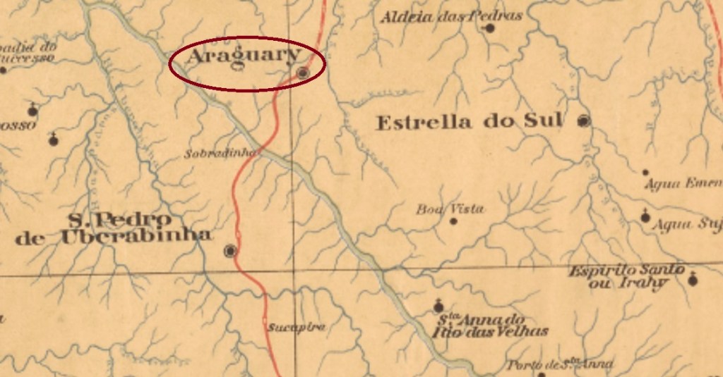
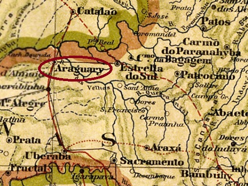
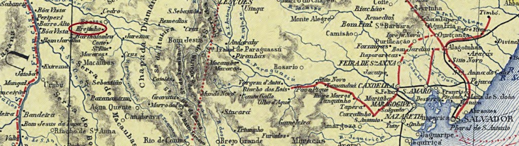
This village was the Freguesia of Brejo Alegre (Happy Swamp) from April 1864, belonging to the Município of Bagagem, located 650 km west of the provincial capital Ouro Preto. In October 1882 it became a vila and in August 1888 a town, named Araguary, after the great river that flows a few kilometres to the south, which was called earlier Rio das Velhas.
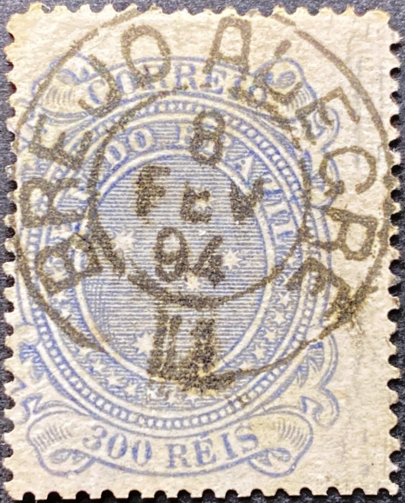
As Paula Sobrinho writes in História Postal de Minas Gerais (Belo Horizonte, 1997), there was a post office in Brejo Alegre since September 1883. The only 19th century postmark so far is BMG-0395a (Coll. Luis C. Fritzen). This specimen bears a date from 1894, when the town had long since been called Araguary:
BMG-0395a (LCF) 1894
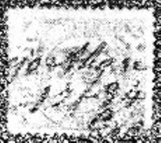
R. Koester shows a handwritten cancellation under the place name Brejo Alegre in Carimbologia II:
1884 (RK)
For postmarks with Araguary see AMG-0105.
Mappa Geral do Brasil, 1911
Textaktualisierung vom 15. Juni 2023
Siehe auch Araguary (AMG-0105)
Diese Ortschaft war ab April 1864 die Freguesia von Brejo Alegre (Fröhlicher Sumpf), die dem Município von Bagagem angehörte und 650 km westlich der Provinzhauptstadt Ouro Preto entfernt lag. Im Oktober 1882 wurde daraus eine Vila und im August 1888 eine Stadt, die dem Namen Araguary trug, in Anlehnung am großen Fluss, der ein Paar km südlich fließt und früher auch Rio das Velhas hieß.
Wie Paula Sobrinho in História Postal de Minas Gerais (Belo Horizonte, 1997) schreibt, gab es in Brejo Alegre ein Postamt seit September 1883. Der bisher einzige Poststempel im 19. Jahrhundert ist BMG-0395a (Samml. Luis C. Fritzen). Dieses Exemplar trägt ein Datum aus 1894, als der Ort schon längst Araguary hieß:
BMG-0395a (LCF) 1894
R. Koester zeigt eine handschriftliche Entwertung unter dem Ortsnamen Brejo Alegre in Carimbologia II:
Villiers de l’Ile Adam: Carta (…) das Provincias de Pernambuco, Alagoas e Sergipe, 1848
Other names: Brejo da Madre de Deus, Tabocas
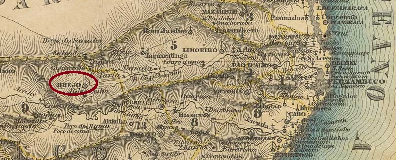
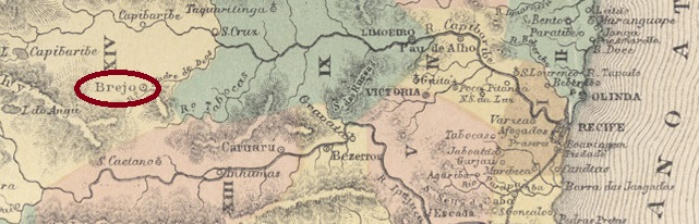
The former settlement of Tabocas was located 200 km west of the later provincial capital of Recife and became the parish of S. José do Brejo da Madre de Deus (St. Joseph at the Marsh of the Mother of God), belonging to the Vila of Flores, in August 1799. It was promoted to vila in May 1833 and to town in February 1879. The parish had its name shortened to Madre de Deus in December 1938, but 10 years later the name Brejo returned.
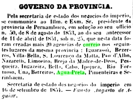
The local post office came into being at least twice. First in September 1854, as Nova Monteiro wrote in Administrações e Agencias Postaes do Brasil Imperio (Brasil Filatelico/RJ, 1934-5; reprint SPP 1994-1999), and confirmed by the regional press:
Diario de Pernambuco, 07.10.1854
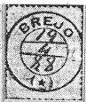
The second date in January 1865 can only be found in Nova Monteiro (op. cit.) and was not confirmed yet. The only imperial postmark so far is the French type BPE-0130b, which was already seen in R. Koester’s Carimbologia VI:
BPE-0130b (RK) 1885-1890Atlas do Imperio do Brasil, 1868
Andere Namen: Brejo da Madre de Deus, Tabocas
Die frühere Siedlung von Tabocas lag 200 km westlich der späteren Provinzhauptstadt Recife entfernt und wurde im August 1799 zur Pfarrei von S. José do Brejo da Madre de Deus (St. Joseph am Sumpf der Mutter Gottes), die der Vila von Flores gehörte. Im Mai 1833 erfolgte der Aufstieg zur Vila und im Februar 1879 zur Stadt. Die Gemeinde hat ihren Namen im Dezember 1938 zu Madre de Deus gekürzt bekommen, doch 10 Jahre später kehrte die Bezeichnung Brejo zurück.
Das örtliche Postamt wurde mindestens zweimal ins Leben gerufen. Erstmals im September 1854, wie Nova Monteiro in Administrações e Agencias Postaes do Brasil Imperio (Brasil Filatelico/RJ, 1934-5; Reprint SPP 1994-1999) schrieb, und durch die Regionalpresse bestätigt wurde:
Diario de Pernambuco, 07.10.1854
Der zweite Termin im Januar 1865 ist nur bei Nova Monteiro (op. cit.) zu finden und konnte nicht bestätigt werden. Der bisher einzige kaiserliche Poststempel ist der französische Typus BPE-0130b, der bereits in R. Koesters Carimbologia VI zu sehen war:
Carta da Republica dos Estados Unidos do Brasil, 1892
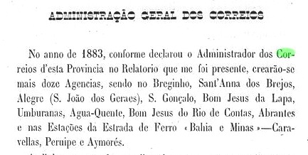
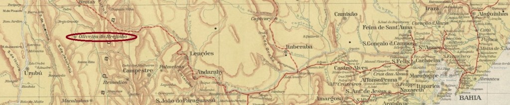
Another name: Oliveira dos Brejinhos
The chapel of N. Sra. de Oliveira was built in 1865 in the Município of Urubu, 610 km west of the provincial capital Salvador da Bahia. In June 1880, the place was declared a freguesia called Brejinho (Little Swamp) and in June 1891, a vila, now called Oliveira do Brejinho. In July 1931 it was downgraded as a district in the Município of Brotas, but since August 1933 Oliveira dos Brejinhos (now plural) is again a Município.
As R. Koester writes in Carimbologia VI, there had been a post office there since September 1883. This is confirmed by the report of the Provisional Government Council of the Province of Bahia the following year:
Relatorio do Conselho Interino do Governo, 1884
The oldest postmark so far is BBA-0155a (coll. FM): a double circle with the inscription BREJINHO above and a five-pointed star below. One specimen known, with a date from 1893 in the centre.
Estado da Bahia, 1913
Anderer Name: Oliveira dos Brejinhos
Die Kapelle von N. Sra. de Oliveira wurde 1865 errichtete und lag im Município von Urubu, 610 km westlich der Provinzhauptstadt Salvador da Bahia entfernt. Im Juni 1880 wurde der Ort zu einer Freguesia names Brejinho (Kleiner Sumpf) und im Juni 1891 zu einer Vila erklärt, die nun Oliveira do Brejinho hieß. Im Juli 1931 kam die Herabstufung als Distrikt im Município von Brotas, aber seit August 1933 ist Oliveira dos Brejinhos (nun im Plural) wieder ein Município.
Wie R. Koester in Carimbologia VI schreibt, gab es dort seit September 1883 ein Postamt. Das wird durch den Bericht des Provisorischen Regierungsrates der Provinz Bahia im Folgejahr bestätigt:
Relatorio do Conselho Interino do Governo, 1884
Der bisher älteste Poststempel ist BBA-0155a (Samml. FM): ein Doppelkreis mit der Inschrift BREJINHO oben und einem fünfzackigen Stern unten. Ein Exemplar bekannt, mit einem Datum aus 1893 in der Mitte.
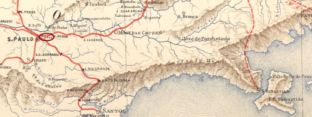
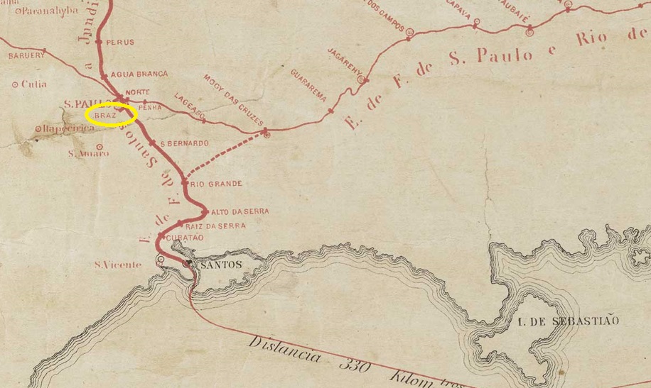
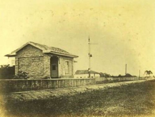
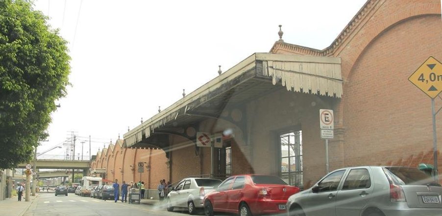
Today’s Brás district is in the middle of the metropolis of São Paulo, but 200 years ago it was a parish in a calm suburb of the then Vila. This quickly changed from February 1867, when Braz station was inaugurated by the São Paulo Railway (Main Line). The railway line changed to E.F. Santos a Jundiaí in 1946, to Rede Ferroviária Federal S.A. in 1975, to Cia. Brasileira de Trens Urbanos in 1983 and has belonged to the Cia. Paulista de Trens metropolitanos (estacoesferroviarias.com.br) since 1992. Today, the Brás (modern writing) district has about 30,000 inhabitants.
1867 (Photo: Militão Azevedo in estacoesferroviarias.com.br)2014 (Photo: Ricardo Koracsony in estacoesferroviarias.com.br)
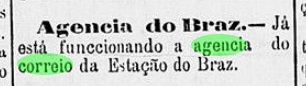
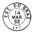
As can be read in the Directory of Imperial Post Offices (Tabella das Agencias do Correio do Imperio, Rio de Janeiro, 1885), the station post office was created in 1879, but apparently only started operating the following year:
A Constituinte, 12.02.1880
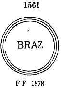
The first postmark here is BSP-0185a, listed in Paulo Ayres’ Catálogo de Carimbos Brasil-Império (S. Paulo, 1937, 1942) under No. 1561:
BSP-0185a (P.A. 1561) 1880ff
It was followed by BSP-0185b, also made known by P. Ayres (op. cit.):
BSP-0185b (P.A. p. 120) 1882-1891
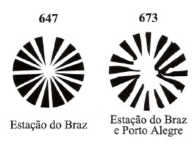
In addition, three mute cancellations from this station have been found, two of them in Mute Cancellations of the Brazil Empire/ Carimbos Mudos do Brasil Império (Brazil Philatelic Association, Rio de Janeiro, 2000), by James Dingler and Klerman W. Lopes:
BPA 647, BPA 673 (1884)
The third mute postmark was shown to us by philatelist Mário Celso Orsi Jr:
1883 (MO)Est. Ferroviarias (…) do Rio de Janeiro, S. Paulo e Minas Geraes, 1880
Der heutige Stadtteil Brás liegt mitten in der Metropole São Paulo, aber vor 200 Jahren war er eine Pfarrei in einem ruhigen Vorort der damaligen Vila. Das änderte sich schnell ab Februar 1867, als der Bahnhof Braz durch die São Paulo Railway (Hauptlinie) eingeweiht wurde. Die Bahnlinie wechselte 1946 zur E.F. Santos a Jundiaí, 1975 zur Rede Ferroviária Federal S.A., 1983 zur Cia. Brasileira de Trens Urbanos und gehört seit 1992 der Cia. Paulista de Trens metropolitanos (estacoesferroviarias.com.br). Heute zählt der Distrikt Brás (wie es nun geschrieben wird) ca. 30.000 Einwohner.
1867 (Foto: Militão Azevedo in estacoesferroviarias.com.br)2014 (Foto: Ricardo Koracsony in estacoesferroviarias.com.br)
Wie im Verzeichnis der kaiserlichen Postämter (Tabella das Agencias do Correio do Imperio, Rio de Janeiro, 1885) zu lesen ist, wurde das Bahnhofspostamt 1879 ins Leben gerufen, nahm sein Betrieb offenbar erst im Folgejahr auf:
A Constituinte, 12.02.1880
Der erste Poststempel hier ist BSP-0185a, der im Paulo Ayres‘ Catálogo de Carimbos Brasil-Império, (S. Paulo, 1937, 1942) unter der Nr. 1561 aufgelistet wurde:
BSP-0185a (P.A. 1561) 1880ff
Ihm folgte BSP-0185b, ebenfalls durch P. Ayres (op. cit.) bekannt gemacht:
BSP-0185b (P.A. p./S. 120) 1882-1891
Darüber hinaus wurden drei stumme Abstempelungen aus diesem Bahnhof gefunden, zwei davon in Mute Cancellations of the Brazil Empire/ Carimbos Mudos do Brasil Império (Brazil Philatelic Association, Rio de Janeiro, 2000), von James Dingler und Klerman W. Lopes:
BPA 647, BPA 673 (1884)
Der dritte stumme Poststempel zeigte uns der Philatelist Mário Celso Orsi Jr.:
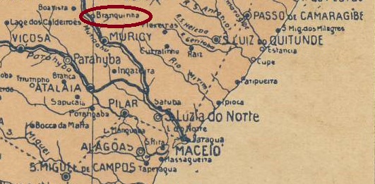
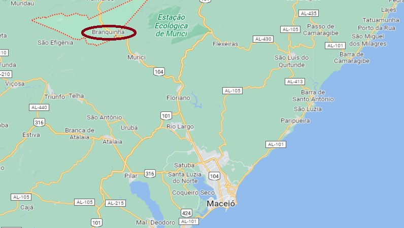
The history of this settlement is being painstakingly reconstructed, as many original documents were destroyed by multiple floods. The settlement was established around 1870 in the Município of Muricy and was located on the north bank of the Mundaú River, 70 km northwest of the provincial capital Maceió. In December 1884, the railway station of the E.F. Central de Alagoas railway company was opened (estacoesferroviarias.com.br).
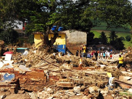
After that, the town grew rapidly: by 1890 it was already a district of Muricy. The railway line changed hands in 1903 to the Great Western Railway Co., in 1951 to Rede Ferroviária do Nordeste and from 1975 until its closure in 1997, the line belonged to Rede Ferroviária Federal S.A. Since May 1962, Branquinha has been an independent município. Today, the railway tracks are still there, the station building was destroyed in the 2010 flood.
After the 2010 flood (Photo: Lula Castelo Branco, in estacoesferroviarias.com.br)
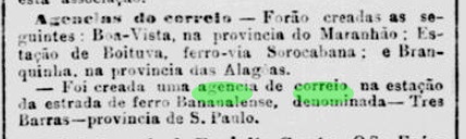
Two dates of origin for the local post office have been found. The first one in 1886, as Aldo Cardoso writes in Contribuição para a História dos Correios de Alagoas (Maceió, 1969). Then in February 1889, as reported by the Rio press:
Jornal do Commercio/RJ, 01.03.1889
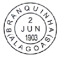
The oldest postmark so far is also a reconstruction (Fig. L. Claudio Fritzen):
BAL-0040a (LCF) 1903Google Maps
Die Geschichte dieser Ortschaft wird mühsam rekonstruiert, da viele Originaldokumente durch mehrfache Überschwemmungen zerstört wurden. Die Siedlung entstand um 1870 im Município von Muricy und lag am Nordufer des Flusses Mundaú, 70 km nordwestlich der Provinzhauptstadt Maceió entfernt. Im Dezember 1884 wurde der Bahnhof der Bahngesellschaft E.F. Central de Alagoas eingeweiht (estacoesferroviarias.com.br).
Danach wuchs der Ort schnell: 1890 war er bereits ein Distrikt von Muricy. Die Bahnlinie wechselte 1903 zur Great Western Railway Co., 1951 zur Rede Ferroviária do Nordeste und von 1975 bis zur Stilllegung 1997 gehörte die Linie der Rede Ferroviária Federal S.A. Seit Mai 1962 ist Branquinha ein eigenständiger Município. Heute sind die Bahnschienen noch da, das Bahnhofsgebäude wurde bei der Überschwemmung 2010 zerstört.
Nach der Überschwemmung (Foto: Lula Castelo Branco, in estacoesferroviarias.com.br)
Zwei Entstehungszeitpunkte fürs örtliche Postamt wurden gefunden. Erstmals 1886, wie Aldo Cardoso in Contribuição para a História dos Correios de Alagoas (Maceió, 1969) schreibt. Dann im Februar 1889, wie die Presse aus Rio berichtete:
Jornal do Commercio/RJ, 01.03.1889
Der bisher älteste Poststempel ist auch eine Rekonstruktion (Abb. L. Claudio Fritzen):
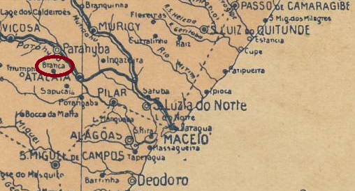
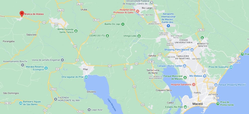
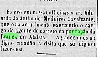
Santo Antonio de Padua de Branca was a small settlement belonging to the Freguesia of Sapucaia in the Município of Atalaia in the 19th century, 55 km northwest of the later provincial capital of Maceió. Since April 1954 it has been called Branca do Atalaia, now as a rural suburb in the district of Sapucaia.
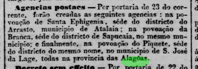
The local post office was established in July 1884, as reported by the Rio Press:
Jornal do Commercio/RJ, 24/07/1884
The agency closed sometime around 1900, as the last press report on local postal services is from December 1898:
O Orbe, 13.12.1898
The imperial postmark is BAL-0035a and has already been shown by R. Koester in Carimbologia VI:
BAL-0035a (RK) 1887Google Maps
Anderer Name: Branca do Atalaia
Santo Antonio de Padua de Branca war eine kleine Siedlung, die im 19. Jahrhundert der Freguesia von Sapucaia im Município von Atalaia gehörte und 55 km nordwestlich der späteren Provinzhauptstadt Maceió entfernt lag. Seit April 1954 heißt sie Branca do Atalaia, nun als ländlicher Vorort im Distrikt von Sapucaia.
Das örtliche Postamt wurde im Juli 1884 ins Leben gerufen, wie die Rio-Presse berichtete:
Jornal do Commercio/RJ, 24.07.1884
Die Agentur schloss irgendwann um 1900, da die letzte Pressemeldung über Postdienste vor Ort aus Dezember 1898 stammt:
O Orbe, 13.12.1898
Der kaiserliche Poststempel ist BAL-0035a und wurde bereits durch R. Koester in Carimbologia VI gezeigt:
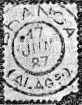
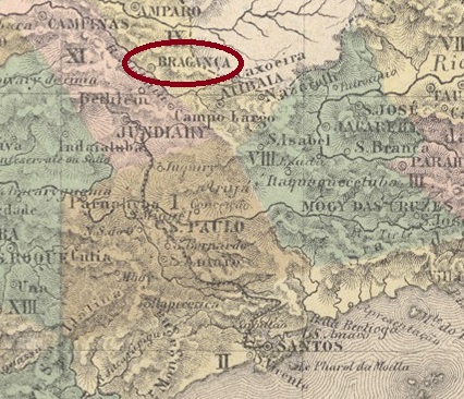
Other names: Conceição do Jaguary, Nova Bragança, Bragança Paulista (1944)
The settlement of N. Sa. da Conceição do Jaguary was established in 1763 and was located close to the south bank of the Jaguary River, barely 90 km north of the future provincial capital of São Paulo. It became a freguesia in December 1765 and changed jurisdiction to the Vila of Atibaia in June 1769. In October 1797 it was promoted to a vila called Nova Bragança, and in April 1856 it became a town. Finally, in November 1944, the Município was renamed to the current Bragança Paulista, probably to avoid confusion with places of the same name.
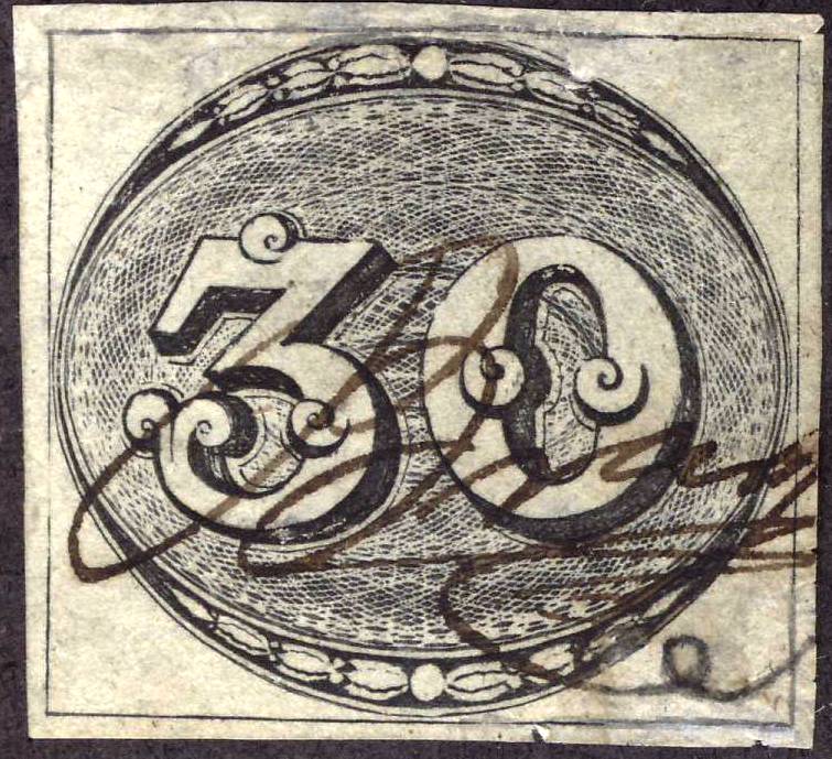
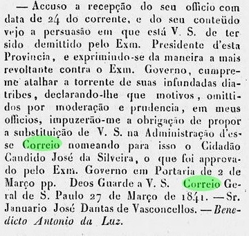
Two dates of origin for the local post office were found. The first was in August 1829, as can be read in Nova Monteiro’s Administrações e Agencias Postaes do Brasil Imperio (Brasil Filatelico/RJ, 1934-5; Reprint SPP 1994-1999). The second agency creation is said to have taken place in 1844, as listed in the Directory of Imperial Post Offices (Tabella das Agencias do Correio do Imperio, Rio de Janeiro, 1885). It has not been possible to find out when the agency was closed in the meantime. In March 1841 there was another turbulent change of postal agent, as reported in the regional press:
Phenix, 12 May 1841
The oldest postmark is BSP-0180a, found for the period 1832-1843ff, also occurring in red and found in the RHM catalogue under RHM-P-SP-05:
BSP-0180a (RHM-P-SP-05)
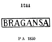
It was followed by BSP-0180b, which was seen on covers between 1843 and 1868 – also in red and green – and already presented by Paulo Ayres in Catálogo de Carimbos Brasil-Império (S. Paulo, 1937, 1942) under no. 1244:
BSP-0180b (P.A. 1244)
Paulo Ayres also shows the same postmark with the legend BRAGANÇA under no. 1243, but according to R. Koester (Carimbologia VI), this is a mistake.
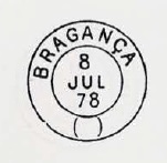
The next cancel is also known from the Ayres’s book: BSP-0180c was used between 1878 and 1888. Possibly this postmark – with a different number entered by hand below – was also used in Bragança in the province of Pará (BPA-0050):
BSP-0180c (P.A. p. 120) 1878-1888
Then came the French type BSP-0180d (fig. from the Internet): a double circle with the inscription BRAGANÇA above and the star between brackets below. Dates in the middle: 1889-1894.
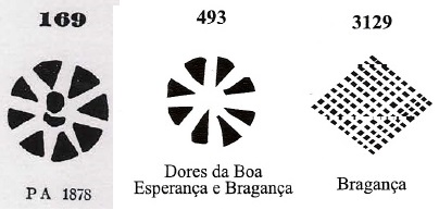
From Bragança there were also three mute cancellations:
Then there is also in my collection a handwritten cancellation from the turbulent 40s:
1843ff (FM)Villiers de l’Ile Adam: Carta (…) da Provincia de São Paulo, 1847
Andere Namen: Conceição do Jaguary, Nova Bragança, Bragança Paulista (1944)
Die Siedlung von N. Sa. da Conceição do Jaguary entstand 1763 und lag nah am Südufer des Flusses Jaguary, knapp 90 km nördlich der späteren Provinzhauptstadt São Paulo entfernt. Sie wurde im Dezember 1765 zu einer Freguesia und wechselte die Zuständigkeit im Juni 1769 zur Vila von Atibaia. Im Oktober 1797 folgte der Aufstieg zu einer Vila, die Nova Bragança hieß, und im April 1856 wurde daraus eine Stadt. Im November 1944 kam schließlich die Umbenennung des Município zum aktuellen Bragança Paulista, wohl um Verwechslungen mit gleichnamigen Orten zu vermeiden.
Zwei Entstehungstermine fürs örtliche Postamt wurden gefunden. Erstmals im August 1829, wie in Nova Monteiros Administrações e Agencias Postaes do Brasil Imperio (Brasil Filatelico/RJ, 1934-5; Reprint SPP 1994-1999) zu lesen ist. Die zweite Posteröffnung soll 1844 stattgefunden haben, wie im Verzeichnis der kaiserlichen Postämter (Tabella das Agencias do Correio do Imperio, Rio de Janeiro, 1885) aufgelistet. Wann zwischendurch die Agentur geschlossen wurde, konnte nicht ermittelt werden. Im März 1841 kam es noch zu einem turbulenten Wechsel des Postagenten, wie die Regionalpresse berichtete:
Phenix, 12. Mai 1841
Der älteste Poststempel ist BSP-0180a, der für den Zeitraum 1832-1843ff gefunden wurde, auch in Rot vorkommt und im RHM-Katalog unter RHM-P-SP-05 zu finden ist:
BSP-0180a (RHM-P-SP-05)
Ihm folgte BSP-0180b,auf Belegen zwischen 1843 und 1868 – auch in Rot und Grün – zu sehen, und bereits durch Paulo Ayres in Catálogo de Carimbos Brasil-Império (S. Paulo, 1937, 1942) unter Nr. 1244 vorgestellt:
BSP-0180b (P.A. 1244)
Paulo Ayres zeigt auch unter Nr. 1243 denselben Poststempel mit Legende BRAGANÇA, was aber lt. R. Koester (Carimbologia VI) ein Irrtum ist.
Den nächsten Stempel kennen wir auch aus dem Ayres-Buch: BSP-0180c wurde zwischen 1878 und 1888 verwendet. Möglicherweise war dieser Poststempel – mit anderer Nummer unten per Hand eingetragen – auch in Bragança in der Provinz Pará (BPA-0050) verwendet:
BSP-0180c (P.A. p./S. 120) 1878-1888
Dann kam der französische Typus BSP-0180d (Abb. aus dem Internet): ein Doppelkreis mit der Inschrift BRAGANÇA oben und dem Stern zwischen Klammern unten. Daten in der Mitte: 1889-1894.
Aus Bragança waren auch drei stumme Abstempelungen zu finden:
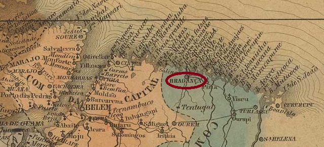
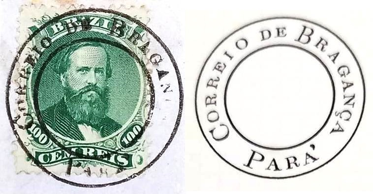
This Bragança at the gates of the Amazon forest had been a settlement since February 1622 in the then still existing Capitania of Gurupi, which was elevated to the Vila de N. Sra. do Rosário de Bragança in 1753, then in the Capitania of Grão-Pará. It was located on the west bank of the Caeté River, 210 km east of the later provincial capital of Belém do Pará. Bragança has been a town since October 1854.
A local post office is said to have existed there since March 1829, as Nova Monteiro writes in Administrações e Agencias Postaes do Brasil Imperio (Brasil Filatelico/RJ, 1934-5; Reprint SPP 1994-1999). The oldest postmark so far is BPA-0050a , which has already been shown by R. Koester in Carimbologia VI:
BPA-0050a (RK) 1850ff
From the Fuad Ferreira Fo. collection comes the beautiful BPA-0050b, used around 1866:
BPA-0050b (FF) 1866ff
Its successor BPA-0050c has yet to be confirmed, as the illustration in Paulo Ayres’ Catálogo de Carimbos Brasil-Império (S. Paulo, 1937, 1942) shows a postmark which, due to its open brackets at the bottom, was also used in the locality of the same name in the province of São Paulo:
BPA-0050c (P.A. p. 120)
BPA-0050d (Fig. Roberto Eissler), on the other hand, can clearly be assigned to Bragança in Pará. This double circle reads BRAGANÇA above and (PARÁ) below. The only specimen so far bears a date from 1890 in the centre.
Villiers de l’Ile Adam: Carta (…) das Provincias do Grão-Pará e Alto Amazonas, 1850
Textaktualisierung am 27. Juni 2023
Diese Bragança vor den Toren Amazoniens war seit Februar 1622 eine Siedlung in der damlas noch existierender Kapitanie von Gurupi, die 1753 zur Vila de N. Sra. do Rosário de Bragança erhoben wurde, dann in der Kapitanie von Grão-Pará. Sie lag am Westufer des Flusses Caeté, 210 km östlich der späteren Provinzhauptstadt Belém do Pará. Seit Oktober 1854 ist Bragança eine Stadt.
Ein örtliches Postamt soll es dort seit März 1829 geben, wie Nova Monteiro in Administrações e Agencias Postaes do Brasil Imperio (Brasil Filatelico/RJ, 1934-5; Reprint SPP 1994-1999) schreibt. Der bisher älteste Poststempel ist BPA-0050a, der bereits durch R. Koester in Carimbologia VI gezeigt wurde:
BPA-0050a (RK) 1850ff
Aus der Sammlung Fuad Ferreira Fo. kommt der schöne BPA-0050b, der um 1866 verwendet wurde:
BPA-0050b (FF) 1866ff
Sein Nachfolger BPA-0050c muss noch bestätigt werden, da die Abbildung in Paulo Ayres’ Catálogo de Carimbos Brasil-Império (S. Paulo, 1937, 1942) einen Poststempel zeigt, der durch seine offene Klammer unten auch in der gleichnamigen Ortschaft der Provinz São Paulo Verwendung fand:
BPA-0050c (P.A. S. 120)
BPA-0050d (Abb. Roberto Eissler) ist dafür eindeutig dem Bragança in Pará zuzuordnen. In diesem Doppelkreis liest man BRAGANÇA oben und (PARÁ) unten. Das bisher einzige Exemplar trägt ein Datum aus 1890 in der Mitte.
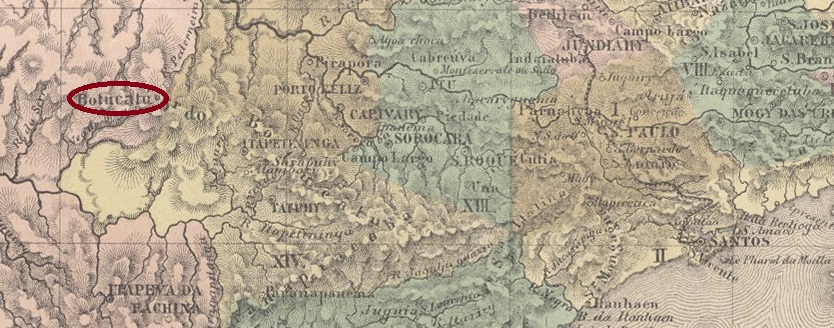
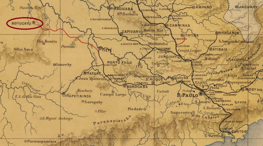
The settlement of N. Sra. das Dores da Serra de Botucatu was founded in December 1843 and was located close to the south bank of the Tietê River, 230 km northwest of the provincial capital of São Paulo. In February 1846, the locality rose as a district in the Município of Itapetininga, in April 1855 it became a vila and in March 1876 a town.
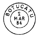
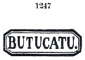
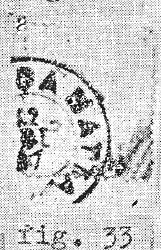
The local post office is dated October 1856, as Nova Monteiro writes in Administrações e Agencias Postaes do Brasil Imperio (Brasil Filatelico/RJ, 1934-5; Reprint SPP 1994-1999). The oldest postmark so far, BSP-0175a, also appears in dark purple, was in use from at least 1866 to 1877 and was already presented by Paulo Ayres in Catálogo de Carimbos Brasil-Império (S. Paulo, 1937, 1942):
BSP-0175a (P.A. 1247)
It was followed by the double circle BSP-0175b, also shown by P. Ayres, also used in blue and violet, and found with inner dates from 1878 to 1893:
BSP-0175b (P.A. p. 120)
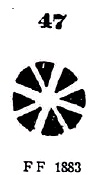
Two mute cancellations are also known from Botucatu. The philatelist Mário Celso Orsi Jr. registered the postmark No. 47 of P. Ayres (op. cit.):
P.A. 47 / BPA 437, 1880-1883ff
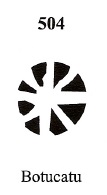
And James Dingler and Klerman W. Lopes have also listed a Botucatu cancellation under no. 504 in Mute Cancellations of the Brazil Empire / Carimbos Mudos do Brasil Império (Brazil Philatelic Association, Rio de Janeiro, 2000):
BPA 504J. M. Ribeiro Lisboa: Provincia de São Paulo, 1884
Die Siedlung von N. Sra. das Dores da Serra de Botucatu wurde im Dezember 1843 gegründet und lag nah am Südufer des Flusses Tietê, 230 km nordwestlich der Provinzhauptstadt São Paulo entfernt. Im Februar 1846 stieg die Ortschaft als Distrikt im Município von Itapetininga, im April 1855 wurde sie eine Vila und im März 1876 eine Stadt.
Das örtliche Postamt ist vom Oktober 1856, wie Nova Monteiro in Administrações e Agencias Postaes do Brasil Imperio (Brasil Filatelico/RJ, 1934-5; Reprint SPP 1994-1999) schreibt. Der bisher älteste Poststempel BSP-0175a erscheint auch in dunkelviolett, war im Gebrauch von mindestens 1866 bis 1877 und wurde bereits durch Paulo Ayres in Catálogo de Carimbos Brasil-Império (S. Paulo, 1937, 1942) vorgestellt:
BSP-0175a (P.A. 1247)
Ihm folgte der Doppelkreis BSP-0175b, der ebenfalls durch P. Ayres bekannt ist, mit inneren Daten von 1878 bis 1893 gefunden und auch in Blau und Violett verwendet wurde:
BSP-0175b (P.A. S. 120)
Aus Botucatu sind auch zwei stumme Abstempelungen bekannt. Der Philatelist Mário Celso Orsi Jr. registrierte den Poststempel Nr. 47 von P. Ayres (op. cit.):
P.A. 47 / BPA 437, 1880-1883ff
James Dingler und Klerman W. Lopes haben auch in Mute Cancellations of the Brazil Empire / Carimbos Mudos do Brasil Império (Brazil Philatelic Association, Rio de Janeiro, 2000) eine Botucatu-Entwertung unter Nr. 504 aufgelistet:
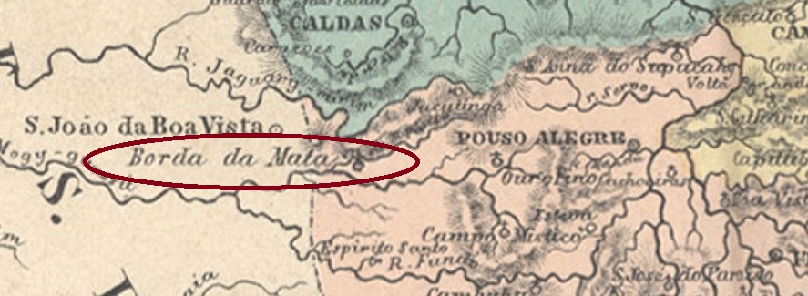
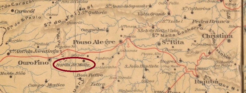
The chapel of N. Sra. do Carmo da Borda da Mata was built in 1823 and was located on the south bank of the Mandu River, 460 km southwest of the provincial capital of Ouro Preto. The village became a district in the Município of Pouso Alegre in July 1858 and a vila in its own Município in September 1923.
Paula Sobrinho writes in História Postal de Minas Gerais (Belo Horizonte, 1997) that there was a post office there since July 1881. The first postmark is BMG-0385a and was already made known by R. Koester in Carimbologia V:
BMG-0385a (RK) 1887-1902Estado de Minas Geraes, 1910
Die Kapelle von N. Sra. do Carmo da Borda da Mata wurde 1823 errichtet und lag am Südufer des Flusses Mandu, 460 km südwestlich der Provinzhauptstadt Ouro Preto entfernt. Der Ort wurde im Juli 1858 ein Distrikt im Município von Pouso Alegre und im September 1923 eine Vila im eigenen Município.
Paula Sobrinho schreibt in História Postal de Minas Gerais (Belo Horizonte, 1997), dass es dort seit Juli 1881 ein Postamt gab. Der erste Poststempel ist BMG-0385a und wurde bereits durch R. Koester in Carimbologia V bekannt gemacht: