Categories
Carimbologia A-B

Agua Quente, Bahia (ABA-0030)

Carta da Republica dos Estados Unidos do Brazil, 1892

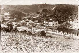
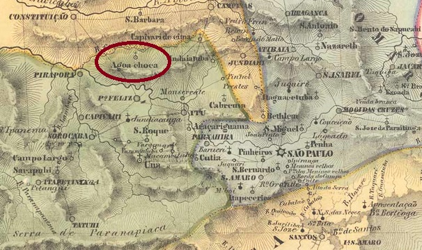
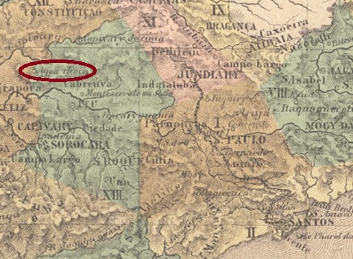
Other names: Arraial do Morro do Fogo, Erico Cardoso (1985)

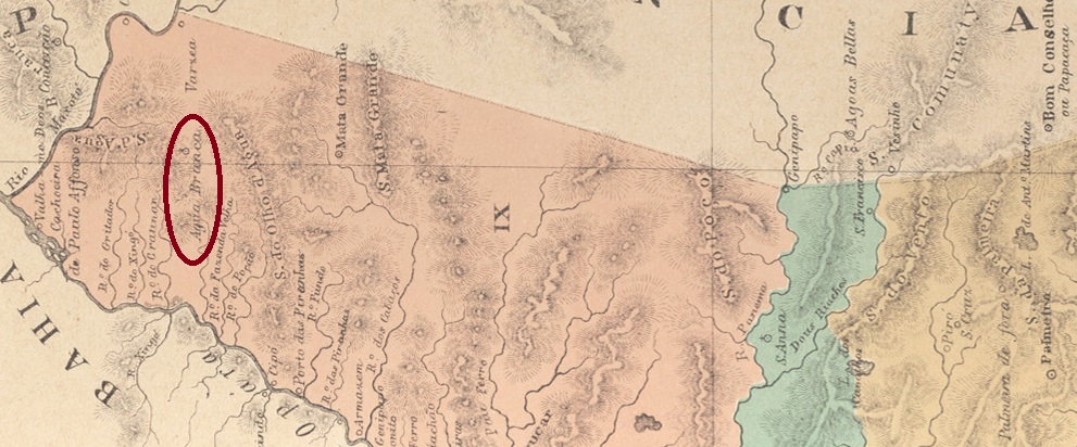
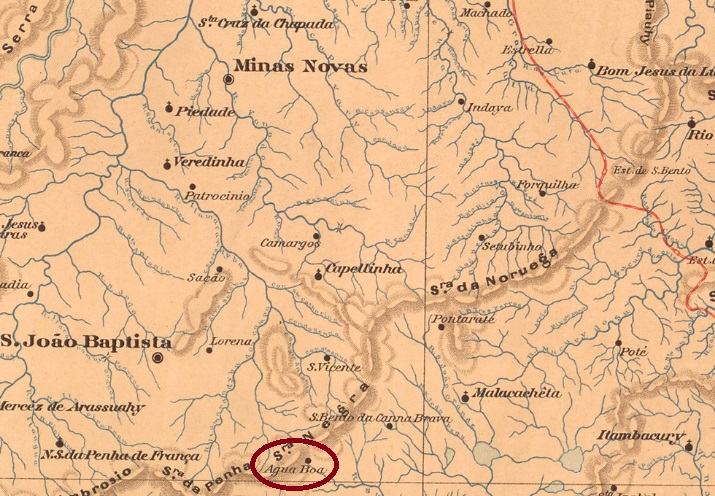
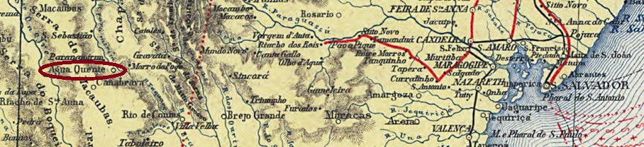
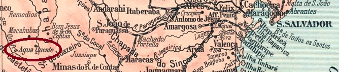
The history of the village begins in May 1843, with the foundation of the Freguesia of N. Sra. do Carmo do Morro do Fogo in the Município of Paramirim, which was located on the south bank of the Paramirim River, 560 km west of the provincial capital Salvador. Afterwards, the village received its autonomy three times: in September 1878 as Industrial Villa de Agua Quente, in May 1890 and in June 1962, as an independent Município. In between, Agua Quente became a district of Rio de Contas in June 1881 and a district of the Município of Paramirim in June 1909. Since July 1985, the municipality has had the name of its first mayor: Erico Cardoso (1918-1984).

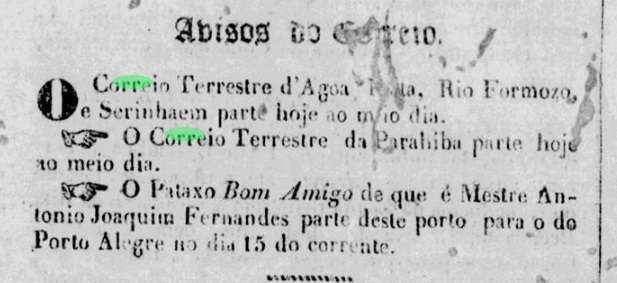
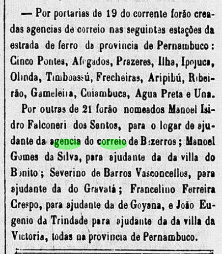
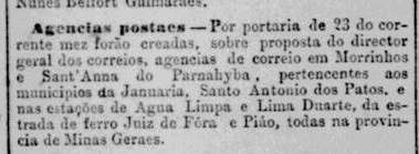
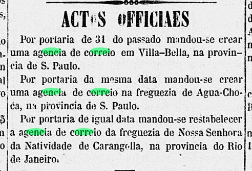
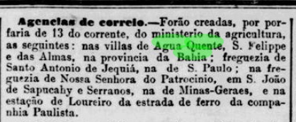
The local post office was established in August 1881, according to the Rio press:

Jornal do Commercio/RJ, 15/08/1881

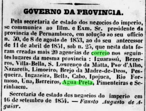
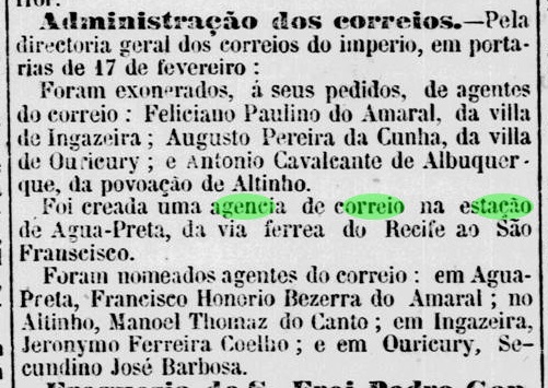
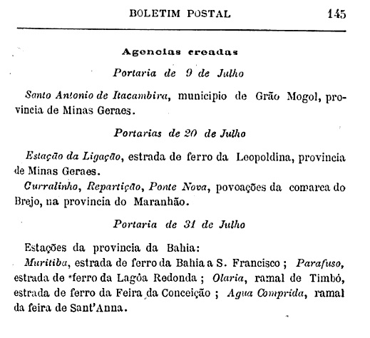
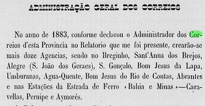
Another date of creation is probably 1883, according to the report of the provincial government council for the following year:

Relatorio do Conselho Interino do Governo, 1884

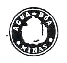
The first postmark is probably ABA-0030a (Coll. FM): a simple double circle with the above inscription AGUA QUENTE. The only specimen so far bears a date from 1890 in the centre.

Estado da Bahia, 1913

Andere Namen: Arraial do Morro do Fogo, Erico Cardoso (1985)

Die Ortsgeschichte fängt im Mai 1843 an, mit der Gründung der Freguesia von N. Sra. do Carmo do Morro do Fogo im Município von Paramirim, die am Südufer des Flusses Paramirim lag, 560 km westlich der Provinzhauptstadt Salvador entfernt. Danach erhielt der Ort seine Autonomie dreimal: im September 1878 als Industrial Villa de Agua Quente, im Mai 1890 und im Juni 1962, als eigenständiger Município. Zwischendurch wurde Agua Quente im Juni 1881 ein Distrikt von Rio de Contas und im Juni 1909 ein Distrikt vom Município von Paramirim. Seit Juli 1985 trägt die Gemeinde den Namen seines ersten Prefeito: Erico Cardoso (1918-1984).

Das örtliche Postamt wurde im August 1881 ins Leben gerufen, wie die Presse aus Rio mitteilt:

Jornal do Commercio/RJ, 15.08.1881

Ein weiterer Entstehungstermin wird vermutlich 1883 sein, laut Bericht des provinzialen Regierungsrats fürs folgende Jahr:

Relatorio do Conselho Interino do Governo, 1884

Der erste Poststempel ist vermutlich ABA-0030a (Samml. FM): ein schlichter Doppelkreis mit der obigen Inschrift AGUA QUENTE. Das bisher einzige Exemplar trägt ein Datum aus 1890 in der Mitte.

Categories
Carimbologia A-B

Agua Preta, Pernambuco (APE-0010)

Atlas do Imperio do Brasil, 1868

Text update of May 6, 2023

The freguesia of São José da Agonia da Água Preta was founded in December 1809, located on the west bank of the Una River at the Vila of Rio Formoso, 120 km southwest of the future provincial capital of Recife. It was promoted to Vila three times (March 1846, May 1869 and May 1879) and in between became a district of Barreiros (May 1853) and of Palmares (May 1873). Agua Preta has been a city since July 1895.

As can be seen from the regional press, a post office was opened there at least twice. The first post office opening must have taken place by December 1833, as a postal route to Agua Preta was active at the time:

Diario de Pernambuco, 06.12.1833

The second creation date for the post office is from September 1854:

Diario de Pernambuco, 07.10.1854

So far, no postmark has been seen from this locality in the imperial period. It is likely that this post office was closed when the Agua Preta station post office (APE-0011), located 10 km further north, was created in December 1864.

Carta Corographica da Provincia de Pernambuco, 1880

Textaktualisierung vom 6. Mai 2023

Die Freguesia von São José da Agonia da Água Preta wurde im Dezember 1809 gegründet und lag am Westufer des Flusses Una bei der Vila von Rio Formoso, 120 km südwestlich der späteren Provinzhauptstadt Recife entfernt. Der Ort stieg dreimal zur Vila auf (März 1846, Mai 1869 und Mai 1879) und wurde zwischendurch ein Distrikt von Barreiros (Mai 1853) bzw. von Palmares (Mai 1873). Seit Juli 1895 ist Agua Preta eine Stadt.

Wie aus der Regionalpresse zu entnehmen ist, wurde dort mindestens zweimal ein Postamt eröffnet. Die erste Posteröffnung muss bis Dezember 1833 stattgefunden haben, da damals eine Postroute nach Agua Preta aktiv war:

Diario de Pernambuco, 06.12.1833

Die zweite Posteröffnung ist vom September 1854:

Diario de Pernambuco, 07.10.1854

Bisher wurde kein Poststempel in der Kaiserzeit aus dieser Ortschaft gesehen. Es ist anzunehmen, dass dieses Postamt geschlossen wurde, als das 10 km weiter nördlich gelegene Bahnhofspostamt von Agua Preta (APE-0011) im Dezember 1864 in Betrieb genommen wurde.

Categories
Carimbologia A-B

Agua Preta (train station/Bahnhof), Pernambuco (APE-0011)

Carta Corographica da Provincia de Pernambuco, 1880

Another name: Joaquim Nabuco (1892)

Agua Preta station was inaugurated in September 1862 by the E.F. de Recife ao São Francisco railway company and was located 110 km southwest of Recife, and about 10 km north of the Vila of Agua Preta. The railway line changed hands in 1901 to the Great Western, and in 1950 to the Rede Ferroviária do Nordeste; from 1975 until its closure in 1996 it belonged to the Rede Ferroviária Federal (estacoesferroviarias.com.br).

Photo: estacoesferroviarias.com.br

The settlement around the station continued to grow and in November 1892 became the district of Joaquim Nabuco, now in the Município of Palmares. Since December 1953, Joaquim Nabuco has been an independent município. The name commemorates the Recife-born lawyer, politician, historian and journalist (1849-1910).

Scott C77, Michel 745

Two dates of origin for the station post office have been found. First in December 1864, as reported by the Press as Rio:

Constitucional/RJ, 24.12.1864

Then again in February 1873, as reported by the regional press:

Diario de Pernambuco, 05.03.1873

Two postmarks were found for the 19th century, unfortunately not the oldest of them. APE-0011b (image from the internet) is a French type, a double circle with the inscription EST. DA AGUA-PRETA at the top and the typical star between brackets at the bottom. The dates in the centre (between 1884 and 1888) were written by hand. APE-0011c (Coll. Paulo Renato Risi) is also a double circle, now has the inscription AGUA-PRETA at the top and (E) at the bottom. The only specimen so far is light blue, dated 1894 in the centre.

IBGE, 1898

Anderer Name: Joaquim Nabuco (1892)

Der Bahnhof Agua Preta wurde im September 1862 durch die E.F. de Recife ao São Francisco-Bahngesellschaft eingeweiht und lag 110 km südwestlich von Recife, sowie ca. 10 km nördlich der Vila von Agua Preta. Die Bahnlinie wechselte 1901 zur Great Western und 1950 zur Rede Ferroviária do Nordeste; von 1975 bis zur Stilllegung 1996 gehörte sie der Rede Ferroviária Federal (estacoesferroviarias.com.br).

Foto: estacoesferroviarias.com.br

Die Siedlung um den Bahnhof wuchs weiter und wurde im November 1892 zum Distrikt von Joaquim Nabuco, nun im Município von Palmares. Seit Dezember 1953 ist Joaquim Nabuco ein eigenständiger Município. Der Name erinnert an den in Recife geborenen Juristen, Politiker, Historiker und Journalist (1849-1910).

Scott C77, Michel 745

Zwei Entstehungsdaten fürs Bahnhofspostamt wurden gefunden. Erstmals im Dezember 1864, wie die Presse aus Rio mitteilte:

Constitucional/RJ, 24.12.1864

Dann nochmals im Februar 1873, wie aus der Regionalpresse hervorgeht:

Diario de Pernambuco, 05.03.1873

Zwei Poststempel wurden für das 19. Jahrhundert gefunden, leider nicht der älteste. APE-0011b (Abb. aus dem Internet) ist ein Französischer Typus, ein Doppelkreis mit der Inschrift EST. DA AGUA-PRETA oben und dem typischen Stern zwischen Klammern unten. Die Daten in der Mitte (zwischen 1884 und 1888) wurden mit der Hand eingetragen. APE-0011c (Samml. Paulo Renato Risi) ist ebenfalls ein Doppelkreis, hat nun oben die Inschrift AGUA-PRETA und unten (E). Das bisher einzige Exemplar ist hellblau, datiert 1894 in der Mitte.

Categories
Carimbologia A-B

Agua Limpa (Minas Novas), Minas Gerais (AMG-0030)

Provincia de Minas Geraes, 1873

Other names: Agua Suja, Berilo (1923)

The former Freguesia of N. Sra. da Conceição da Água Suja was founded in September 1870 in the Município of Minas Novas and was located at the mouth of the stream Água Suja (Dirty Waters) in the Araçuaí River, 530 km north of the provincial capital Ouro Preto. The authorities apparently did not like the place name, so in November 1887 it was changed to Água Limpa (Clean Waters). The stream kept its old name until today. The village was then called Berilo in September 1923 and has been an independent município since December 1962.

Two dates of origin were found for the local post office. The first was in August 1888, according to the Rio Press:

Jornal do Commercio/RJ 11.08.1888

The second date is given by Paula Sobrinho in História Postal de Minas Gerais (Belo Horizonte, 1997) exactly two years later and may therefore be a transcription error. So far, no imperial postmark from this locality could be identified with certainty.

Estado de Minas Geraes, 1910

Andere Namen: Água Suja, Berilo (1923)

Die frühere Freguesia von N. Sra. da Conceição da Água Suja wurde im September 1870 im Município von Minas Novas gegründet und lag an der Mündung des Bachs Água Suja (Schmutziges Gewässer) in den Araçuaí-Fluss, 530 km nördlich der Provinzhauptstadt Ouro Preto entfernt. Der Ortsname gefiel der Obrigkeit offenbar nicht, also wurde daraus im November 1887 die Freguesia von Água Limpa (Sauberes Gewässer). Dabei behielt der Bach den alten Namen bis heute. Die Ortschaft hieß dann ab September 1923 Berilo und ist seit Dezember 1962 ein eigenständiger Município.

Zwei Entstehungsdaten wurden fürs örtliche Postamt gefunden. Erstmals im August 1888, wie aus der Rio-Presse hervorgeht:

Jornal do Commercio/RJ 11.08.1888

Das zweite Datum wird von Paula Sobrinho in História Postal de Minas Gerais (Belo Horizonte, 1997) exakt zwei Jahre später angegeben und darf somit ein Abschreibfehler sein. Bisher konnte kein kaiserlicher Poststempel aus dieser Ortschaft mit Sicherheit identifiziert werden.

Categories
Carimbologia A-B

Agua Limpa (train station/Bahnhof), Minas Gerais (AMG-0031)

Estado de Minas Geraes, 1910

Another name: Coronal Pacheco (ca. 1905)

This station presents a bit of a mystery. What is certain is that it was inaugurated at the end of 1884 by the E.F. de Juiz de Fora a Piau railway company and was located about 180 km south of the provincial capital Ouro Preto. This was also announced in the regional press at the time:

Pharol, 25.11.1884

One reads in estacoesferroviarias.com.br that the station was renamed Coronel Pacheco, and this can also be seen on the Minas map of 1910 (see above). However, there were both names for neighbouring stations at that time, as the train timetable of January 1910 reveals:

Pharol, 04.01.1910

The only plausible explanation would be that the former Lima Duarte station was initially renamed Coronel Pacheco (there had been another village called Lima Duarte in Minas Gerais since October 1884, formerly called Dores do Rio do Peixe and located west of Juiz de Fora), but soon disappeared, so that the former Agua Limpa station now became Coronel Pacheco. Colonel José Manoel Pacheco (1840-1914) was a large landowner in the region who co-founded the railway company and was thus practically set as the station’s name giver. The station has also been in the Município of Coronel Pacheco since December 1962. The railway line passed to E.F. Leopoldina between 1884 and 1913 and remained so until the end of operations in 1974.

A station post office existed from April 1885, according to the Rio de Janeiro press release:

Jornal do Commercio/RJ 24.04.1885

No imperial postmark from this station has yet appeared.

E.F. Leopoldina

Anderer Name: Coronel Pacheco (ca. 1905)

Dieser Bahnhof stellt ein kleines Rätsel dar. Sicher ist, dass er Ende 1884 durch die E.F. de Juiz de Fora a Piau-Bahngesellschaft eingeweiht wurde und ca. 180 km südlich der Provinzhauptstadt Ouro Preto lag. So wurde auch damals in der Regionalpresse bekannt gegeben:

Pharol, 25.11.1884

Allerdings liest man in estacoesferroviarias.com.br, dass der Bahnhof zu Coronel Pacheco umbenannt wurde, und so kann man auch auf der Minas-Karte von 1910 (s.o.) sehen. Nun aber gab es damals wohl beide Namen für benachbarte Bahnhöfe, wie der Zugfahrplan von Januar 1910 verrät:

Pharol, 04.01.1910

Die einzige plausible Erklärung dafür wäre, dass der frühere Bahnhof Lima Duarte zunächst zu Coronel Pacheco umbenannt wurde (es gab seit Oktober 1884 eine weitere Ortschaft namens Lima Duarte in Minas Gerais, die früher Dores do Rio do Peixe hieß und westlich von Juiz de Fora lag), aber bald verschwand, so dass der frühere Bahnhof Agua Limpa nun zu Coronel Pacheco wurde. Der Oberst José Manoel Pacheco (1840-1914) war ein Großgrundbesitzer der Region, der die Bahngesellschaft mitgegründet hat und dadurch als Bahnhofsnamensgeber praktisch gesetzt wurde. Der Bahnhof liegt seit Dezember 1962 auch im Município von Coronel Pacheco. Die Bahnlinie ging zwischen 1884 und 1913 zu E.F. Leopoldina über und blieb so bis zum Betriebsende 1974.

Ein Bahnhofspostamt gab es seit April 1885, wie aus der Pressemitteilung von Rio de Janeiro hervorgeht:

Jornal do Commercio/RJ 24.04.1885

Bisher ist kein kaiserlicher Poststempel aus diesem Bahnhof aufgetaucht.

Categories
Carimbologia A-B

Agua Fria (train station/Bahnhof), Bahia (ABA-0025)

Carta da Republica dos Estados Unidos do Brazil, 1892

The Freguesia of São João Baptista da Agua Fria (Cold Water) was founded as early as April 1718, it belonged to the Vila of Cachoeira and was located over 150 km north of the capital Salvador da Bahia. In 1727, it was elevated to the status of Vila, but lost its autonomy at the beginning of the 19th century and finally became a district in the Município of Purificação dos Campos in May 1842. In August 1895, Agua Fria transferred as a district to the Município of Irará and emancipated itself in July 1962.

The local railway station was inaugurated in November 1880 by the E.F. da Bahia ao São Francisco. Afterwards, the line changed hands many times: in 1909 to the Cia. Viação Geral da Bahia, in 1911 to the Cie. de Chemins der Fer Fédéraux de l’Est Brésilien, in 1935 to the Viação Férrea Federal Leste Brasileiro, in 1975 to the Rede Ferroviária Federal until the end of operations in 1996. The rails are still there, but the station is now a ruin.

There had been a station post office there since April 1881, as the Rio press reports:

Gazeta de Noticias/RJ, 21.04.1881

No imperial postmark has yet been seen from this station.

Please note: this blog will return ca. 29 August, after a vacation break.

IBGE, 1898

Die Freguesia von São João Baptista da Agua Fria (Kaltes Wasser) wurde bereits im April 1718 gegründet, sie gehörte der Vila von Cachoeira und lag über 150 km nördlich der Hauptstadt Salvador da Bahia entfernt. 1727 wurde der Ort zur Vila erhoben, verlor aber am Anfang des 19 Jahrhunderts seine Eigenständigkeit und wurde schließlich im Mai 1842 zu einem Distrikt im Município von Purificação dos Campos. Im August 1895 wechselte Agua Fria als Distrkt zum Município von Irará und emanzipierte sich im Juli 1962.

Der Ortsbahnhof wurde im November 1880 durch die E.F. da Bahia ao São Francisco eingeweiht. Danach wechselte die Linie oft den Besitzer: 1909 zur Cia. Viação Geral da Bahia, 1911 zur Cie. de Chemins der Fer Fédéraux de l’Est Brésilien, 1935  zur Viação Férrea Federal Leste Brasileiro, 1975 bis Betriebsende 1996 zur Rede Ferroviária Federal. Die Schienen sind noch da, aber der Bahnhof ist jetzt eine Ruine.

Ein Bahnhofspostamt gab es dort seit April 1881, wie die Presse aus Rio berichtet:

Gazeta de Noticias/RJ, 21.04.1881

Bisher ist noch kein kaiserlicher Poststempel aus diesem Bahnhof zu sehen.

Bitte beachten: Dieser Blog macht Urlaub bis ca. 29.8.

Categories
Carimbologia A-B

Agua Cumprida (train station/Bahnhof), Bahia (ABA-0020)

IBGE, 1898

The Água Comprida station (then spelled Cumprida) was inaugurated in September 1860 by the E.F. da Bahia ao São Francisco railway company, located near Salvador da Bahia, 30 km north of the city centre. The railway line (Feira de Sant’Anna branch) changed hands several times: in 1909 to the Cia. Viação Geral da Bahia, in 1911 to the Cie. de Chemins of the Fer Fédéraux de l’Est Brésilien, in 1935 to the Viação Férrea Federal Leste Brasileiro, in 1957 to the Rede Ferroviária Federal S.A. and in 1996 to the Ferrovia Centro-Atlântica. The rails are still there today, and there are plans to reconnect the station with the capital.

estacoesferroviarias.com.br
Photo: Simões Filho (estacoesferroviarias.com.br)

Around the station, the settlement continued to grow; it was elevated to the status of a district in December 1953 and received political autonomy in November 1961 as the Município of Simões Filho. The name commemorates a journalist and politician (1886-1957) who was born in the area.

The station post office did not come into being until July 1889, as reported by the Brazilian Mail:

Boletim Postal No. 4, August 1889

The earliest postmark is probably ABA-0020a (Coll. Claudio Coelho): a double circle with the inscription AGUA CUMPRIDA at the top. The only specimen so far bears a date from 1890 inside.

Estado da Bahia, 1913

Anderer Name: Simões Filho (est.)

Der Bahnhof Água Comprida  (damals Cumprida geschrieben) wurde im September 1860 durch die E.F. da Bahia ao São Francisco Bahngesellschaft eingeweiht und lag bei Salvador da Bahia, 30 km nördlich der Stadtmitte entfernt. Die Bahnlinie (Feira de Sant’Anna-Abzweigung) wechselte mehrmals den Besitzer: 1909 zur Cia. Viação Geral da Bahia, 1911 zur Cie. de Chemins der Fer Fédéraux de l’Est Brésilien, 1935  zur Viação Férrea Federal Leste Brasileiro, 1957 zur Rede Ferroviária Federal S.A. und 1996 zur Ferrovia Centro-Atlântica. Die Schienen sind heute noch da, und es gibt Pläne, den Bahnhof wieder mit der Hauptstadt zu verbinden.

estacoesferroviarias.com.br
Foto Simões Filho (estacoesferroviarias.com.br)

Rund um den Bahnhof wuchs die Siedlung weiter, sie wurde im Dezember 1953 zum Distrikt erhoben und bekam die politische Autonomie im November 1961 als Município von Simões Filho. Der Name erinnert an einen Journalisten und Politiker (1886-1957), der in der Gegend geboren wurde.

Das Bahnhofspostamt entstand erst im Juli 1889, wie der Boletim Postal Nr. 4 berichtet:

Boletim Postal Nr. 4, August 1889

Der früheste Poststempel ist wohl ABA-0020a (Samml. Claudio Coelho): ein Doppelkreis mit der Inschrift AGUA CUMPRIDA oben. Das bisher einzige Exemplar trägt ein Datum aus 1890 im Inneren.

Categories
Carimbologia A-B

Agua Choca, São Paulo (ASP-1820)

Villiers de l’Ile Adam: Carta (…) da Provincia de São Paulo, 1847

Other names: N. Sra. do Patrocinio do Capivari de Cima, Monte-Mor

See also Monte-Mor (R. Koester: Carimbologia XXVII)

Around 1829, the settlement of N. Sra. do Patrocínio do Capivari de Cima was established, situated on the northern bank of the Capivari River, 120 km northwest of the future provincial capital São Paulo. In August 1832, the place was elevated to a freguesia with the strange name of Agua Choca (Rotten Water), which belonged to the Município of Itu. It was not until March 1871 that the name was changed again, this time as Vila of Monte-Mor (Big Mountain).

Two years of origin were found for the local post office. Firstly in 1854, as found out by philatelist Mario Celso Orsi Jr. Then in March 1865, as reported by the Rio press:

Correio Mercantil/RJ, 02.04.1865

So far no imperial postmark has been seen under this place name. For postmarks with Monte-Mor see Koester, Carimbologia XXVII.

Atlas do Imperio do Brasil, 1868

Andere Namen: N. Sra. do Patrocinio do Capivari de Cima, Monte-Mor

Siehe auch Monte-Mor (R. Koester: Carimbologia XXVII)

Um 1829 entstand die Siedlung von N. Sra. do Patrocínio do Capivari de Cima, die am Nordufer des Flusses Capivari lag, 120 km nordwestlich der künftigen Provinzhauptstadt São Paulo entfernt. Im August 1832 wurde der Ort zu einer Freguesia erhoben, die den merkwürdigen Namen Agua Choca (Verfaultes Wasser) trug und dem Município von Itu angehörte. Erst im März 1871 wurde der Name wieder geändert, diesmal als Vila von Monte-Mor (Großer Berg).

Zwei Entstehungsjahre wurden fürs örtliche Postamt gefunden. Erstmals 1854, wie vom Philatelisten Mario Celso Orsi Jr. Ermittelt. Dann im März 1865, wie die Presse aus Rio mitteilte:

Correio Mercantil/RJ, 02.04.1865

Bisher war kein kaiserlicher Poststempel unter diesem Ortsnamen zu sehen. Für Stempel mit Monte-Mor siehe Koester, Carimbologia XXVII.

Categories
Carimbologia A-B

Agua Branca, Alagoas (AAL-0005)

Atlas do Imperio do Brasil, 1868

Text update of September 14, 2022

The Freguesia of N. Sra. da Conceição da Água Branca originated in 1864 in the Município of Paulo Afonso and was located on the provincial border with Pernambuco, 290 km west of the future capital Maceió. It became a vila in April 1875 and a town in June 1919.

Aldo Cardoso writes in Contribuição para a História dos Correios de Alagoas (Maceió, 1969) that the local post office was created in July 1869. The year is confirmed by the Directory of Imperial Post Offices (Tabella das Agencias do Correio do Imperio, Rio de Janeiro, 1885). A postmark – dated 1895 in the centre – has been found: AAL-0005b (Coll. Fuad Ferreira Fo.) is a double circle with the inscriptions AGUA BRANCA above and (ALAGOAS) below.

Villiers de l’Ile Adam: Carta (…) das Provincias de Penambuco, Alagoas e Sergipe, 1848

Textaktualisierung am 14. September 2022

Die Freguesia von N. Sra. da Conceição da Água Branca entstand 1864 im Município von Paulo Afonso und lag an der Provinzgrenze zu Pernambuco, 290 km westlich der späteren Hauptstadt Maceió entfernt. Im April 1875 wurde der Ort zur Vila und im Juni 1919 zur Stadt erhoben.

Aldo Cardoso schreibt in Contribuição para a História dos Correios de Alagoas (Maceió, 1969), dass das örtliche Postamt im Juli 1869 aus der Taufe erhoben wurde. Das Jahr wird durch das Verzeichnis der kaiserlichen Postämter(Tabella das Agencias do Correio do Imperio, Rio de Janeiro, 1885) bestätigt. Ein Poststempel – datiert 1895 in der Mitte – wurde inzwischen gefunden: AAL-0005b (Samml. Fuad Ferreira Fo.) ist ein Doppelkreis mit den Inschriften AGUA BRANCA oben und (ALAGOAS) unten.

Categories
Carimbologia A-B

Agua Boa, Minas Gerais (AMG-2605)

Estado de Minas Geraes, 1910

Text update on September 2, 2022

Another name: São José da Água Boa

See also Sant’Anna da Água Boa (SMG-2605)

The former district of São José da Água Boa (at the good water) received in May 1877 the name from the brook on place, in the municipality of Minas Novas, and was situated over 400 km north of the provincial capital Ouro Preto. In October 1885 the toponym changed to Sant’Anna da Água Boa, in 1933 it became a district of Capelinha, and finally in December 1953 it emancipated politically as the municipality of Água Boa.

According to Paula Sobrinho (História Postal de Minas Gerais, Belo Horizonte, 1997) the local post office was created in September 1888. The oldest cancel so far found is AMG-2605a, which was presented to us by Paulo Ayres in Catálogo de Carimbos Brasil-Império (S. Paulo, 1937, 1942) on page 145:

AMG-2605a (P.A. p/S. 145)

The next cancel does not mention any patron saint either, but as Reinhold Koester did not register an agency in Água Boa, let’s introduce it as AMG-2605b, as well as SMG-2605b (Coll. Márcio Protzner): a double circle with the inscriptions AGUA BOA above and (MINAS) below. The date at the centre shows the year 1900.

Raphael L. de Abreu (CC BY SA)

Textaktualisierung am 2. September 2022

Anderer Name: São José da Água Boa

Siehe auch Sant’Anna da Água Boa (SMG-2605)

Der ehemalige Distrikt von São José da Água Boa (am guten Gewässer) erhielt im Mai 1877 seinen Namen vom kleinen Fluss vor Ort und lag im Município von Minas Novas, über 400 km nördlich der alten Provinzhauptstadt Ouro Preto entfernt. Im Oktober 1885 änderte sich der Ortsname zu Sant’Anna da Água Boa, 1933 wurde daraus ein Distrikt von Capelinha, und schließlich im Dezember 1953 stieg die Ortschaft zum Município von Água Boa auf.

Laut Paula Sobrinho (História Postal de Minas Gerais, Belo Horizonte, 1997) entstand das örtliche Postamt im September 1888. Der älteste bisher gefundene Stempel ist AMG-2605a, der uns von Paulo Ayres in Catálogo de Carimbos Brasil-Império (S. Paulo, 1937, 1942) auf Seite 145 vorgestellt wurde:

AMG-2605a (P.A. p/S. 145)

Auch der nächste Stempel erwähnt keine/n Schutzpatron/in, aber da Reinhold Koester keine Postagentur in Água Boa notiert hat,, stellen wir ihn als AMG-2605b und auch als SMG-2605b (Samml. Márcio Protzner) hiermit vor: ein Doppelkreis mit den Inschriften AGUA BOA oben und (MINAS) unten. Das Datum in der Mitte zeigt bereits das Jahr 1900.