Categories
Carimbologia A-B

Afogados (APE-0006) – Afogados (train station/Bahnhof), Pernambuco (APE-0007)

Carta Corographica da Provincia de Pernambuco, 1880

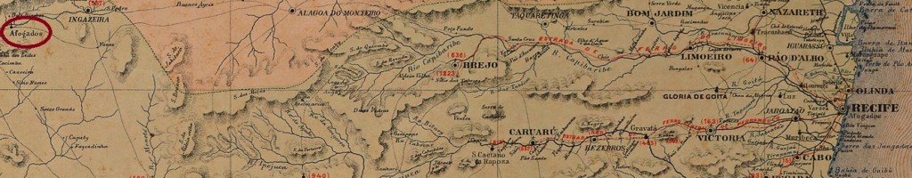
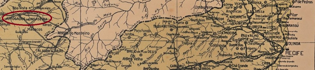
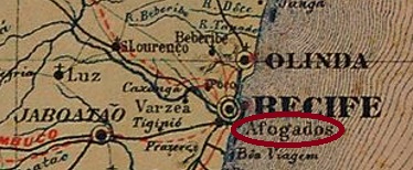
Today, Afogados is a district of Recife, a good 4 km south of the city centre. The name of the station (The Drowned) is meant to remember slaves who died while escaping by swimming at high tide. A railway station of the E.F. Recife ao São Francisco was built there before 1860. The railway line was taken over by the Great Western Railway Company in 1901 and remained in operation until about 1935. Then Afogados was replaced by Ypiranga station, which was, however, on the other line (towards Jaboatão). The station post office was created in December 1864, according to the Rio press:

Constitucional/RJ, 24.12.1864

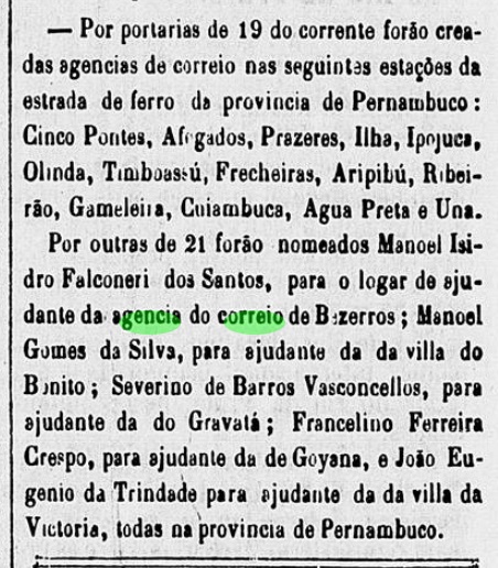
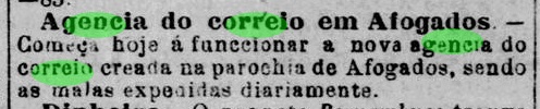
Another post office was also opened in the parish of Afogados in August 1882, according to the local press:

Diario de Pernambuco, 25/08/1882

Presumably, this agency became the successor to the station post office. So far, no imperial postmark from Afogados has turned up, either from the station or from the parish.

Mappa do Recife, 1908

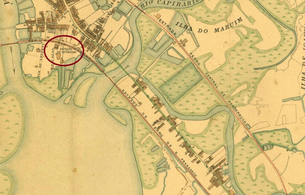
Heute ist Afogados ein Stadtteil von Recife, gut 4 km südlich der Stadtmitte entfernt. . Der Bahnhofsname (Die Ertrunkene) soll an die Sklaven erinnern, die bei ihrer Flucht durch Schwimmen bei Flut verstarben. Dort wurde noch vor 1860 ein Bahnhof der E.F. Recife ao São Francisco gebaut. Die Bahnlinie übernahm 1901 die Great Western Bahngesellschaft und blieb bis ca. 1935 in Betrieb. Dann wurde Afogados durch den Bahnhof Ypiranga ersetzt, der allerdings auf der Nebenlinie (Richtung Jaboatão) lag. Das Bahnhofspostamt wurde im Dezember 1864 ins Leben gerufen, wie die Presse aus Rio mitteilte:

Constitucional/RJ, 24.12.1864

Auch in der Pfarrei Afogados wurde im August 1882 ein weiteres Postamt in Betrieb genommen, wie die Lokalpresse berichtet:

Diario de Pernambuco, 25.08.1882

Vermutlich wurde diese Agentur die Nachfolgerin des Bahnhofspostamts. Bisher ist kein kaiserlicher Poststempel aus Afogados aufgetaucht, weder vom Bahnhof noch aus der Pfarrei.

Categories
Carimbologia A-B

Afogados de Ingazeira, Pernambuco (APE-0005)

Carta Corographica da Provincia de Pernambuco, 1880

Another name: Senhor Bom Jesus dos Remédios

The former parish of Senhor Bom Jesus dos Remédios was established around 1800 in the Freguesia of Ingazeira, which at that time belonged to the Villa of Flores and was located on the south bank of the Pajeú River, 380 km west of the later provincial capital Recife. In May 1852, it became the Villa of Afogados de Ingazeira, which was demoted as a district in the Município of Ingazeira in May 1870, only to regain autonomy – this time as a town – in July 1909. The strange name (Drowned at Ingazeira) comes from a legend according to which a couple died trying to cross the Pajeú when the water level was high.

There had been a post office there since 1873, as can be seen from the Directory of Imperial Post Offices (Tabella das Agencias do Correio do Imperio, Rio de Janeiro, 1885). The imperial postmark is APE-0005a (Coll. Jorge L. Pedreira): a French type with the inscription AFOGADOS D’INGAZEIRA above and the typical star between brackets below. The dates in the middle – as far as recorded – go so far from 1885 to 1887.

Arthur D. Ribeiro: Estado de Penambuco, 1924

Anderer Name: Senhor Bom Jesus dos Remédios

Die ehemalige Pfarrei Senhor Bom Jesus dos Remédios wurde um 1800 in der Freguesia von Ingazeira errichtet, die damals der Villa von Flores angehörte, und lag am Südufer des Pajeú-Flusses, 380 km westlich der späteren Provinzhauptstadt Recife entfernt. Im Mai 1852 wurde daraus die Villa von Afogados de Ingazeira, die im Mai 1870 als Distrikt im Município von Ingazeira herabgesetzt wurde, um im Juli 1909 die Autonomie – diesmal als Stadt – wieder zu erlangen. Der merkwürdige Name (Ertrunkene bei Ingazeira) entstammt einer Legende, nach der ein Ehepaar verstarb, als es versuch hatte, den Pajeú bei hohem Pegelstand zu durchqueren.

Dort gab es ein Postamt seit 1873 wie aus dem Verzeichnis der kaiserlichen Postämter (Tabella das Agencias do Correio do Imperio, Rio de Janeiro, 1885) hervorgeht. Der kaiserliche Poststempel ist APE-0005a (Samml. Jorge L. Pedreira): ein Französischer Typ mit der Inschrift AFOGADOS D’INGAZEIRA oben und dem typischen Stern zwischen Klammern unten. Die Daten in der Mitte –soweit vorhanden – gehen bisher von 1885 bis 1887.

Categories
Carimbologia A-B

Affuá, Pará (APA-0012)

Carta dos Estados Unidos do Brazil, 1892

Text update of September 5, 2022

The Freguesia of N. Sra. da Conceição do Affuá (today spelled Afuá) was founded in April 1874 in the Município of Chaves and located on the right bank of the Afuá River on Marajó Island. The distance to the provincial capital Belém do Pará is 275 km as the crow flies, but to get there it still takes 37 hours for an almost 2,000 km long boat trip… As one can easily imagine, the state infrastructure was anything but stable here as well: the freguesia status was revoked a short time later, granted again in March 1880 and revoked again in November 1882. It was not until August 1890 that the place became a villa, and in May 1896 a town.

It has not yet been possible to find out when the post office was created there. The earliest mention of it was found in the provincial president’s report for October 1884:

Relatorio do Presidente da Provincia, October 1884

There one also reads that although Affuá was an important port on the way to Macapá and the islands of the Amazon Delta, the place consisted of a single street on palisades, on which all buildings – private and public – were erected, including the post office. This is quite plausible, for even today Afuá’s post office is literally shown above water (see below).

A second post office opening took place in April 1890, as reported in the postal bulletin of that year. From this second period of activity comes the rare cancel APA-0012a (Coll. Fuad Ferreira Fo.), dated November 1894: a double circle with the inscriptions AFFUÁ above and (PARÁ) below.

Google Maps

Textaktualisierung am 5. September 2022

Die Freguesia von N. Sra. da Conceição do Affuá (heute Afuá geschrieben) wurde im April 1874 im Município von Chaves gegründet und lag am rechten Ufer des Flusses Afuá auf der Marajó-Insel. Die Entfernung zur Provinzhauptstadt Belém do Pará beträgt zwar 275 km Luftlinie, aber um dorthin zu kommen braucht man noch heute 37 Stunden für eine fast 2.000 km lange Schiffsreise… Wie man sich leicht vorstellen kann, war auch hier die staatliche Infrastruktur alles andere als stabil: der Freguesia-Status wurde kurze Zeit später aberkannt, im März 1880 wieder vergeben und im November 1882 nochmals aberkannt. Erst im August 1890 wurde der Ort eine Villa, und im Mai 1896 eine Stadt.

Es war bisher nicht möglich herauszufinden, seit wann es dort ein Postamt gab. Die früheste Erwähnung befindet sich im Bericht des Provinzpräsidenten für Oktober 1884:

Relatorio do Presidente da Provincia, Oktober 1884

Dort liest man auch, dass obwohl Affuá ein wichtiger Hafen auf dem Weg nach Macapá und zu den Inseln des Amazonas–Delta war, bestand der Ort aus einer einzigen Straße auf Palisaden, worauf alle Gebäude – private wie öffentliche – errichtet wurden, auch das Postamt. Daran glaubt man gerne, wenn sogar heute die Post Afuás buchstäblich über Wasser gezeigt wird (siehe oben).

Eine zweite Postamteröffnung fand im April 1890 statt, wie der Postbulletin des Jahres berichtet. Aus dieser zweiten Tätigkeitsperiode stammt der seltene Stempel APA-0012a (Samml. Fuad Ferreira Fo.), datiert November 1894: ein Doppelkreis mit den Inschriften AFFUÁ oben und (PARÁ) unten.

Categories
Carimbologia A-B

Acary, Rio Grande do Norte (ARN-0005)

Atlas do Imperio do Brasil, 1868

Text updated on September 2, 2022

Acary (now spelled acari) is the tupi name for various armoured catfishes of the family Loricariidae, such as the Pterygoplichtys pardalis (cascudo-abacaxi, Rafinesque, 1815):

Photo: Derek Ramsey (CC BY SA)

The freguesia of N. Sra. da Guia do Acary was founded in March 1835 on the north bank of the Acauã River, near Villa do Principe (now Caicó), 210 km west of the provincial capital Natal. Just one month later, the place received the status of a villa and became a town in August 1898.

Two years of origin for the local post office were found. Firstly in May 1818, as Nova Monteiro writes in Administrações e Agencias Postaes do Brasil Imperio (Brasil Filatelico/RJ, 1934-5; Reprint SPP 1994-1999). Then again 1838 – and this one seems more plausible – as listed in the Directory of Imperial Post Offices (Tabella das Agencias do Correio do Imperio, Rio de Janeiro, 1885).

So far, the oldest postmark is ARN-0005c (Coll. Márcio Protzner): a double circle with the inscription ACARY above. The only copy found has a date of 1895 in the centre.

Villiers de l’Ile Adam: Carta (…) das Provincias do Rio Grande do Norte e Parahiba

Textaktualisierung am 2. September 2022

Acary (heute acari geschrieben) ist der Tupi-Name für diverse Panzerwelse der Familie Loricariidae, wie z.B. der Pterygoplichtys pardalis (cascudo abacaxi, Rafinesque, 1815):

Foto: Derek Ramsey (CC BY SA)

Die Freguesia von N. Sra. da Guia do Acary wurde im März 1835 am Nordufer des Flusses Acauã gegründet und lag bei der Villa do Principe (heute Caicó), 210 km westlich der Provinzhauptstadt Natal entfernt. Bereits ein Monat später erhielt der Ort den Status einer Villa und wurde im August 1898 eine Stadt.

Zwei Entstehungsjahre fürs örtliche Postamt wurden gefunden. Erstmals im Mai 1818, wie Nova Monteiro in Administrações e Agencias Postaes do Brasil Imperio (Brasil Filatelico/RJ, 1934-5; Reprint SPP 1994-1999) schreibt. Dann wieder 1838 – und dieses erscheint plausibler, wie im Verzeichnis der kaiserlichen Postämter (Tabella das Agencias do Correio do Imperio, Rio de Janeiro, 1885) aufgelistet.

Der bisher älteste Stempel ist ARN-0005c (Samml. Márcio Protzner): ein Doppelkreis mit der Aufschrift ACARY darüber. Das einzige gefundene Exemplar trägt in der Mitte die Jahreszahl 1895.

Categories
Carimbologia A-B

Acarape, Ceará (ACE-0010)

Villiers de l’Ile Adam: Carta (…) da Provincia do Ceará, 1849

Text update on September 7, 2022

See also Redempção (RCE-0267)

The Freguesia of N. Sa. da Conceição do Acarape was founded in March 1842 in the Villa of Baturité and was located on the north bank of the Acarape River, 65 km south of the provincial capital Fortaleza. The word Acarape comes from the Tupi language and means way of the Acarás (a fish of the Cichlidae family). In December 1868, the place was elevated to the status of a villa, and since August 1889 it has been the town of Redempção (now spelled Redenção). The renaming is a reminder that this was the first locality in Brazil to abolish slavery. This took place on 1 January 1883, more than five years before the rest of the country.

The local post office was established in the first half of 1872, according to the regional press:

Cearense, 04.07.1872

In the meantime, an old cancellation from Acarape has been discovered, dated 1897 or 1898. ACE-0010b (Coll. Fuad Ferreira Fo.) is a double circle with the inscriptions ACARAPE above and (CEARÁ) below. This means that we can practically rule out the existence of postmarks with Redempção during the Empire.

Atlas do Imperio do Brasil, 1868

Textaktualisierung am 7. September 2022

Siehe auch Redempção (RCE-0267)

Die Freguesia von N. Sa. da Conceição do Acarape wurde im März 1842 in der Villa von Baturité gegründet und lag am Nordufer des Flusses Acarape, 65 km südlich der Provinzhauptstadt Fortaleza entfernt. Das Wort Acarape kommt aus der Tupi-Sprache und bedeutet Weg der Acarás (ein Fisch der Familie Cichlidae). Im Dezember 1868 wurde der Ort zur Villa erhoben, und seit August 1889 ist es die Stadt Redempção (heute Redenção geschrieben). Die Umbenennung erinnert daran, dass diese die erste Ortschaft Brasiliens war, die die Sklaverei abgeschafft hat. Dies fand am 1.1.1883 statt, und damit gut fünf Jahre vor dem Rest des Landes.

Das örtliche Postamt entstand in der ersten Hälfte des Jahres 1872, wie die Regionalpresse berichtet:

Cearense, 04.07.1872

Inzwischen wurde eine alte Abstempelung von Acarape entdeckt, datiert 1897 oder 1898. ACE-0010b (Samml. Fuad Ferreira Fo.) ist ein Doppelkreis mit den Inschriften ACARAPE oben und (CEARÁ) unten. Damit können wir praktisch ausschließen, dass es Poststempel mit Redempção aus dem Kaiserreich gibt.

Categories
Carimbologia A-B

Acaracú (ACE-0365) – Acarahú, Ceará (ACE-0005)

Villiers de l’Ile Adam: Carta (…) da Provincia do Ceará, 1849

Text updated on September 2, 2022

The freguesia called Sant’Anna de Acaracú came into being in September 1766, it was subordinated to the Villa of Sobral and located on the east bank of the Acaraú River, 230 km west of the later provincial capital Fortaleza. In July 1849, the village rose to the status of Villa, whose name was changed to Acarahú in January 1879, probably to have a more pleasant sound. Since September 1882, Acaraú (as it is written today) has been a town.

Two periods of operation for the local post office have been reported. It is not yet known when it was first opened. It is certain that the post office was closed in March 1847.

Gazeta Official/RJ, 24.03.1847

The second creation of the post office in Acaracú took place in January 1858, as reported by the regional press:

Pedro II/ 03.04.1858

So far, no postmark with the old spelling ACARACÚ has appeared. With ACARAHÚ we know ACE-0005a, as illustrated in the Catálogo de Carimbos Brasil-Império (S. Paulo, 1937, 1942) by Paulo Ayres, on page 145:

ACE-0005a (P.A. p/S. 145)

This was followed by ACE-0005b (illustration from the Internet): a double circle with an ornament in lozenge at the bottom, formed by four small lozenges and dated 1890-1900 in the centre.

Atlas do Imperio do Brasil, 1868

Textaktualisierung am 2. September 2022

Die Freguesia namens Sant’Anna de Acaracú entstand im September 1766, sie unterstand der Villa von Sobral und lag am Ostufer des Flusses Acaraú, 230 km westlich der späteren Provinzhauptstadt Fortaleza entfernt. Im Juli 1849 stieg der Ort zur Villa auf, deren Name im Januar 1879 zu Acarahú geändert wurde, wohl um einen angenehmeren Klang bemüht. Seit September 1882 ist Acaraú (wie man es heute schreibt) eine Stadt.

Zwei Betriebsperioden fürs örtliche Postamt wurden ermittelt. Wann es erstmals eröffnet wurde, ist noch nicht bekannt. Sicher ist es, dass die Postagentur im März 1847 geschlossen wurde.

Gazeta Official/RJ, 24.03.1847

Die zweite Entstehung der Post in Acaracú fand im Januar 1858 statt, wie die Regionalpresse berichtet:

Pedro II/ 03.04.1858

Bisher ist kein Poststempel mit der alten Schreibweise ACARACÚ aufgetaucht. Mit ACARAHÚ kennen wir ACE-0005a, wie im Catálogo de Carimbos Brasil-Império (S. Paulo, 1937, 1942) von Paulo Ayres, auf Seite 145 abgebildet:

ACE-0005a (P.A. p/S. 145)

Es folgte ACE-0005b (Abb. aus dem Internet): ein Doppelkreis mit einem Ornament in Raute unten, das aus vier kleinen Rauten gebildet wird. Datiert 1890-1900 in der Mitte.

Categories
Carimbologia A-B

Acará, Pará (APA-0010)

Villiers de l’Ile Adam: Carta (…) das Provincias do Grão Pará e Alto Amazonas, 1850

Acará is the indigenous name for fish of the family Cichlidae, which is widespread throughout Brazil. In the north of the country, it usually refers to the genus Astronotus, such as the Oscarfish (Astronotus Ocellatus, Agassiz 1831):

Foto: Oscaroscar, Wikipedia

The parish of São José de Acará was established in 1758 on the north bank of the Acará River, near Mojú, 100 km south of the later provincial capital Belém do Pará. It was elevated to villa status in April 1875 but passed as a district of the provincial capital in November 1930, rising again to villa status in January 1932. 

The local post office was probably first established around June 1877, according to the regional press:

Jornal do Pará, 14.07.1877

However, as problems with the local postal service soon became public, the post office closed soon after. Further openings took place in 1880, as listed in the Directory of Imperial Post Offices (Tabella das Agencias do Correio do Imperio, Rio de Janeiro, 1885), and in March 1882, according to a press release from Rio de Janeiro:

O Globo/RJ, 24.03.1882

Given these dates, it is extremely unlikely that postmark no. 1190, as presented by Paulo Ayres in Catálogo de Carimbos Brasil-Império (S. Paulo, 1937, 1942) with use date “from 1843”, is genuine:

P.A. 1190

Possibly there is confusion here, e.g., with the stamp P.A. 1274, from the province of Ceará:

P.A. 1274

Beyond that, no other postmarks from imperial Acará are known.

Atlas do Imperio do Brasil, 1868

Acará ist der im ganzen Brasilien verbreitete indigene Name für Fische der Familie Cichlidae, wobei im Norden des Landes meistens die Gattung Astronotus gemeint ist, wie z.B. der Pfauenaugenbuntbarsch (Astronotus Ocellatus, Agassiz 1831):

Foto: Oscaroscar – Wikipedia

Die Pfarrei von São José de Acará wurde 1758 am Nordufer des Flusses Acará errichtet und lag bei Mojú, 100 km südlich der späteren Provinzhauptstadt Belém do Pará entfernt. Im April 1875 wurde der Ort zur Villa erhoben, ging aber im November 1930 als Distrikt der Landeshauptstadt, um im Januar 1932 nochmals zu einer Villa aufzusteigen. 

Das örtliche Postamt wurde wohl erstmals um Juni 1877 ins Leben gerufen, wie die Regionalpresse berichtet:

Jornal do Pará, 14.07.1877

Da es aber bald Probleme mit dem Postbetrieb vor Ort publik wurden, schloss das Postamt wenig später. Weitere Eröffnungen erfolgten 1880, wie imVerzeichnis der kaiserlichen Postämter (Tabella das Agencias do Correio do Imperio, Rio de Janeiro, 1885) aufgelistet, und im März 1882, laut einer Pressemittelung aus Rio de Janeiro:

O Globo/RJ, 24.03.1882

Angesichts dieser Daten ist es äußert unwahrscheinlich, dass der Poststempel Nr. 1190, wie ihn Paulo Ayres in Catálogo de Carimbos Brasil-Império (S. Paulo, 1937, 1942) mit Verwendungszeit „ab 1843“ präsentiert hatte, echt ist:

P.A. 1190

Möglicherweise liegt hier eine Verwechslung vor, z.B. mit dem Stempel P.A. 1274, aus der Provinz Ceará:

P.A. 1274

Darüber hinaus sind keine weiteren Poststempel aus dem kaiserlichen Acará bekannt.

Categories
Carimbologia A-B

Abre Campos, Minas Gerais (AMG-0025)

Atlas do Imperio do Brasil, 1868

Text update of August 31, 2022

Recte: Abre Campo

This locality with the curious name (Open the Field) was a freguesia of Mariana from April 1846, located on the west bank of the Sant’Anna River, barely 150 km east of the provincial capital Ouro Preto. In July 1850, it changed to the Município of Ponte Nova, became a villa in July 1889 and a town in May 1892.

There was a post office there from March 1872, as Paula Sobrinho writes in História Postal de Minas Gerais (Belo Horizonte, 1997). The year is confirmed by the Directory of Imperial Post Offices (Tabella das Agencias do Correio do Imperio, Rio de Janeiro, 1885). The oldest imperial postmark so far is AMG-0025a (Coll. Fuad Ferreira Fo.): a double circle with the upper inscription ABRE-CAMPO, with internal dates from 1884 to 1886. Its successor AMG-0025b has an incorrect place name (CAMPOS instead of CAMPO) and has already been presented by R. Koester (Carimbologia I, 1961):

AMG-0025b (RK) 1887-1899
Villiers de l’Ile Adam: Carta (…) da Povincia de Minas Geres, 1849

Textaktualisierung vom 31.08.2022

Recte: Abre Campo

Diese Ortschaft mit dem merkwürdigen Namen (Öffne das Feld) war ab April 1846 eine Freguesia von Mariana, die am Westufer des Flusses Sant’Anna lag, knapp 150 km östlich der Provinzhauptstadt Ouro Preto. Im Juli 1850 wechselte der Ort zum Município von Ponte Nova, wurde im Juli 1889 eine Villa und im Mai 1892 eine Stadt.

Dort gab es ein Postamt seit März 1872, wie Paula Sobrinho in História Postal de Minas Gerais (Belo Horizonte, 1997) schreibt. Die Jahresangabe wird durch das Verzeichnis der kaiserlichen Postämter (Tabella das Agencias do Correio do Imperio, Rio de Janeiro, 1885) bestätigt. Der bisher älteste kaiserliche Stempel ist AMG-0025a (Samml. Fuad Ferreira Fo.): ein Doppelkreis mit der oberen Inschrift ABRE-CAMPO, mit internen Daten von 1884 bis 1886. Sein Nachfolger AMG-0025b hat einen falschen Ortsnamen (CAMPOS statt CAMPO) und wurde bereits von R. Koester (Carimbologia I, 1961) vorgestellt:

AMG-0025b (RK) 1887-1899
Categories
Carimbologia A-B

Abrantes, Bahia (ABA-0015)

Villiers de l’Ile Adam: Carta (…) da Provincia da Bahia, 1848

Another name: Montenegro (1925-1938)

Villa do Espírito Santo de Nova Abrantes was built as early as September 1758 and was located on the Atlantic Ocean, 35 km northeast of the former colonial capital Salvador da Bahia. In April 1846, the place was demoted to a freguesia in the Município of Mata de São João, but regained villa status two years later. In July 1925, the place name changed to Montenegro, and in March 1938, the old name returned, but as a district in the Município of Camaçari. And so it has remained until today.

The local post office was established in 1883, as can be seen from the report of the Bahia government council for the following year:

Relatório do Conselho Interino do Governo da Bahia, 1884

So far, no imperial postmark from this place has appeared.

Atlas do Imperio do Brasil, 1868

Anderer Name: Montenegro (1925-1938)

Die Villa do Espírito Santo de Nova Abrantes wurde bereits im September 1758 errichtet und lag am Atlantik, 35 km nordöstlich der früheren Kolonialhauptstadt Salvador da Bahia entfernt. Im April 1846 wurde der Ort zur Freguesia im Município von Mata de São João degradiert, doch erlangte zwei Jahre später den Villa-Status wieder. Im Juli 1925 änderte sich der Ortsname zu Montenegro, und im März 1938 kehrte der alte Name zurück, allerdings als ein Distrikt im Município von Camaçari. Und so ist es bis heute geblieben.

Das örtliche Postamt entstand 1883, wie aus der Bericht des Regierungsrats in Bahia fürs darauf folgende Jahr hervorgeht:

Relatório do Conselho Interino do Governo da Bahia, 1884

Bisher ist kein kaiserlicher Poststempel aus diesem Ort aufgetaucht.

Categories
Carimbologia A-B

Abbadia, Minas Gerais (AMG-0010)

Atlas do Imperio do Brasil, 1868

Other names: Abbadia de Pitanguy, Martinho Campos (1938)

The chapel of Nossa Senhora da Abbadia was built around 1814 and was located on the Picão River, a good 70 km from the villa of Pitangui and over 270 km from the later provincial capital Ouro Preto. In June 1858, the place was elevated to a freguesia. In September 1923, the official place name changed to Abbadia de Pitanguy, and since December 1938 it has been the Município of Martinho Campos. The name commemorates Martinho Álvares da Silva Campos (1816-1887), doctor, senator and provincial president of Rio de Janeiro, who was born in Pitangui:

Instituto Histórico e Geográfico de Minas Gerais

Two years of origin for the local post office were found. Firstly in 1873, as recorded in the Directory of Imperial Post Offices (Tabella das Agencias do Correio do Imperio, Rio de Janeiro, 1885). Then in November 1878, as Paula Sobrinho writes in História Postal de Minas Gerais (Belo Horizonte, 1997). A postmark is registered in the 19th century, unfortunately not the oldest: AMG-0010b is a double circle with the inscription ABBADIA DE PITANGUY on top. The only specimen bears a date from 1895 inside.

Provincia de Minas Geraes, 1873

Andere Namen: Abbadia de Pitanguy, Martinho Campos (1938)

Die Kapelle von Nossa Senhora da Abbadia wurde ca. 1814 errichtet und lag am Fluss Picão, gut 70 km von der Villa von Pitangui und über 270 km von der späteren Provinzhauptstadt Ouro Preto entfernt. Im Juni 1858 wurde der Ort zu einer Freguesia erhoben. Im September 1923 wechselte der amtliche Ortsname zu Abbadia de Pitanguy, und seit Dezember 1938 ist er der Município von Martinho Campos. Der Name erinnert an Martinho Álvares da Silva Campos (1816-1887), Arzt, Senator und Provinzpräsidenten von Rio de Janeiro, der in Pitangui geboren war:

Instituto Histórico e Geográfico de Minas Gerais

Zwei Entstehungsjahre fürs örtliche Postamt wurden gefunden. Erstmals 1873, wie im Verzeichnis der kaiserlichen Postämter (Tabella das Agencias do Correio do Imperio, Rio de Janeiro, 1885) zu lesen ist. Dann im November 1878, wie Paula Sobrinho in História Postal de Minas Gerais (Belo Horizonte, 1997) schreibt. Ein Poststempel ist im 19. Jahrhundert registrieret, leider nicht der älteste: AMG-0010b ist ein Doppelkreis mit der Inschrift ABBADIA DE PITANGUY oben. Das einzige Exemplar trägt ein Datum aus 1895 im Inneren.