Categories
Carimbologia A-B

Abbadia dos Dourados, Minas Gerais (AMG-0020)

Estado de Minas Geraes, 1910

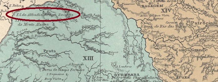
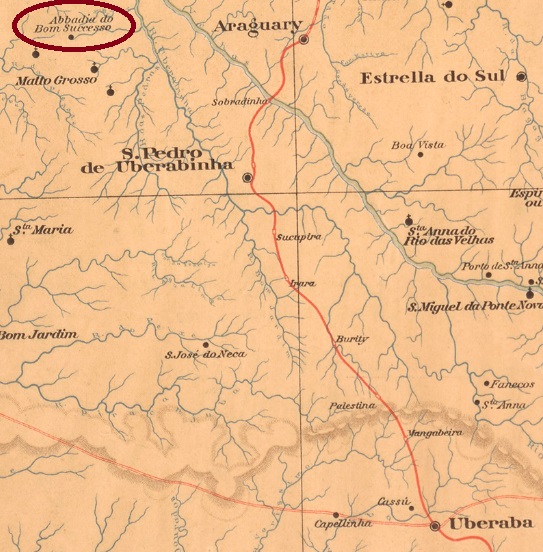
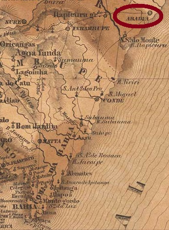
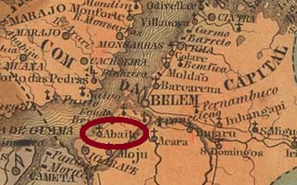
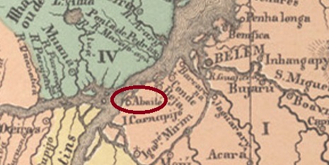
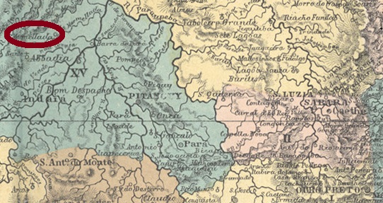
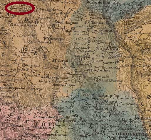
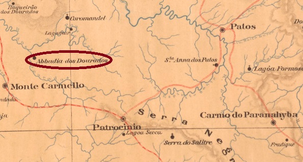
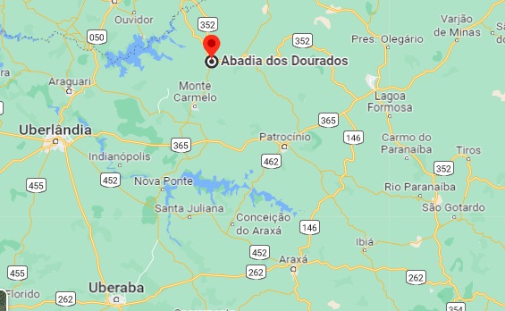
The Freguesia of Nossa Senhora da Abbadia dos Dourados was created in September 1882 in the Município of Patrocínio, located on the north bank of the Dourados River, 600 km northwest of the provincial capital Ouro Preto. The following month, it was transferred to the newly formed Município of Coromandel, then returned to Patrocínio in November 1891, before changing again as a district of Coromandel in September 1923. Since December 1948, Abadia dos Dourados (as it is written today) has been an independent Município

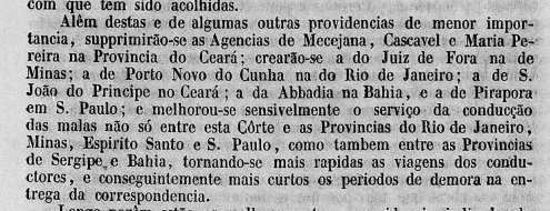
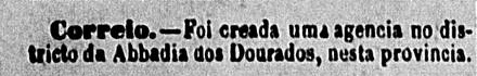
Two dates of origin for the local post office have been found. First in November 1878, as Paula Sobrinho writes in História Postal de Minas Gerais (Belo Horizonte, 1997). Then again in December 1884, as reported in the regional press:

O Baependyano, 28.12.1884

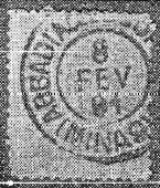
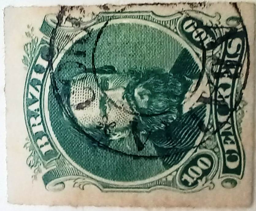
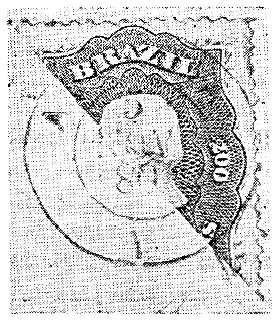
The only 19th century postmark so far is probably from the second period of operation. AMG-0020b was already presented by Reinhold Koester in Carimbologia I (1961):

AMG-0020b (RK) 1891
Google Maps

Die Freguesia von Nossa Senhora da Abbadia dos Dourados wurde im September 1882 im Município von Patrocínio ins Leben gerufen und lag am Nordufer des Flusses Dourados, 600 km nordwestlich der Provinzhauptstadt Ouro Preto entfernt. Gleich im folgenden Monat wechselte der Ort zum neu gegründeten Município von Coromandel, kehrte dann im November 1891 zu Patrocínio zurück, bevor im September 1923 ein abermaliger Wechsel als Distrikt von Coromandel stattfand. Seit Dezember 1948 ist Abadia dos Dourados (wie heute geschrieben wird) ein eigenständiger Município. 

Zwei Entstehungsdaten fürs örtliche Postamt wurden gefunden. Erstmals im November 1878, wie Paula Sobrinho in História Postal de Minas Gerais (Belo Horizonte, 1997) schreibt. Dann wieder im Dezember 1884, wie die Regionalpresse berichtete:

O Baependyano, 28.12.1884

Der bisher einzige Poststempel im 19. Jahnhundert kommt wohl aus der zweiten Betriebsperiode. AMG-0020b wurde bereits durch Reinhold Koester in Carimbologia I (1961) vorgestellt:

AMG-0020b (RK) 1891
Categories
Carimbologia A-B

Abbadia do Bom Successo, Minas Gerais (AMG-0015)

Atlas do Imperio do Brasil, 1868

Text updated on August 20, 2022

Another name: Tupaciguara (1923)

The Freguesia of Nossa Senhora da Abbadia do Bom Successo was created in October 1851 and was located at the Villa of Uberaba, 700 km west of the provincial capital of Ouro Preto. In June 1858, the place changed as a district to the then freshly created Município of Monte Alegre (today: Monte Alegre de Minas) and became a villa in November 1911, which was given the name Tupaciguara in September 1923. The word from the Tupi-Guarani language means Land of the Mother of God. Tupaciguara has been a town since September 1925.

There was a post office there from August 1885, as Paula Sobrinho writes in História Postal de Minas Gerais (Belo Horizonte, 1997). The oldest postmark so far is AMG-0015a (Coll. Márcio Protzner): a double circle with the inscriptions ABBADIA DO BOM SUCCESSO above and (MINAS) below. The internal dates are from the period 1897-1904.

Estado de Minas Geraes, 1910

Textaktualisierung am 20. August 2022

Anderer Name: Tupaciguara (1923)

Die Freguesia von Nossa Senhora da Abbadia do Bom Successo wurde im Oktober 1851 ins Leben gerufen und lag bei der Villa von Uberaba, 700 km westlich der Provinzhauptstadt Ouro Preto entfernt. Im Juni 1858 wechselte der Ort als Distrikt zum damals frisch entstandenen Município von Monte Alegre (heute: Monte Alegre de Minas) und wurde im November 1911 eine Villa, die im September 1923 den Namen Tupaciguara bekam. Das Wort aus der Tupi-Guarani-Sprache bedeutet Land der Mutter Gottes. Seit September 1925 ist Tupaciguara eine Stadt.

Dort gab es ein Postamt ab August 1885, wie Paula Sobrinho in História Postal de Minas Gerais (Belo Horizonte, 1997) schreibt. Der bisher älteste Poststempel ist AMG-0015a (Samml. Márcio Protzner): ein Doppelkreis mit den Inschriften ABBADIA DO BOM SUCCESSO oben und (MINAS) unten. Die Daten entstammen dem Zeitraum 1897-1904.

Categories
Carimbologia A-B

Abbadia, Bahia (ABA-0010)

Atlas do Imperio do Brasil, 1868

Text update on November 7, 2023

Other names: Arraial da Cachoeira, Jandaíra (1927)

The chapel of Nossa Senhora da Abbadia was built as early as 1718, located 200 km north of the former colonial capital Salvador da Bahia, close to the border with Sergipe. In April 1728, it rose to the status of a villa, and in June 1880 it was given the name Arraial da Cachoeira. In August 1927, it became the Villa of Jandaíra.

Two dates of origin for the local post office have been recorded. The first was in October 1851, as Nova Monteiro notes in Administrações e Agencias Postaes do Brasil Imperio (Brasil Filatelico/RJ, 1934-5; Reprint SPP 1994-1999), and confirmed by the report of the Imperial Ministry of the same year:

Relatorio do Ministerio do Imperio, 1851

The second post office creation took place in 1859, as can be read in the Directory of Imperial Post Offices (Tabella das Agencias do Correio do Imperio, Rio de Janeiro, 1885).

The oldest postmark from the imperial era to date is ABA-0010a (collect. Fuad Ferreira Fo.), which was found on stamp issues between 1850 and 1876:

ABA-0010a (FF) 1851ff-1876ff

It was followed by ABA-0010b with a specimen from 1880, as presented by Reinhold Koester (Carimbologia I, 1961):

ABA-0010b (RK) 1880
Villers de l’Ile Adam: Carta (…) da Provincia da Bahia, 1848

Textaktualisierung am 7. November 2023

Andere Namen: Arraial da Cachoeira, Jandaíra (1927)

Die Kapelle von Nossa Senhora da Abbadia wurde bereits 1718 errichtet und lag 200 km nördlich der früheren Kolonialhauptstadt Salvador da Bahia, nah an der Grenze zu Sergipe. Im April 1728 stieg der Ort zur Villa, die im Juni 1880 den Namen Arraial da Cachoeira bekam. Im August 1927 wurde daraus die Villa von Jandaíra.

Zwei Entstehungstermine fürs örtliche Postamt wurden registriert. Erstmals im Oktober 1851, wie Nova Monteiro in Administrações e Agencias Postaes do Brasil Imperio(Brasil Filatelico/RJ, 1934-5; Reprint SPP 1994-1999) vermerkt, und durch den damaligen Bericht des kaiserlichen Ministeriums bestätigt wurde:

Relatorio do Ministerio do Imperio, 1851

Die zweite Postamteröffnung fand 1859 statt, wie man im Verzeichnis der kaiserlichen Postämter (Tabella das Agencias do Correio do Imperio, Rio de Janeiro, 1885) lesen kann.

Der bisher älteste Poststempel aus der Kaiserzeit ist ABA-0010a (Samml. Fuad Ferreira Fo.), der auf Briefmarkenausgaben zwischen 1850 und 1876 gefunden wurde:

ABA-0010a (FF) 1851ff-1876ff

Ihm folgte ABA-0010b mit einem Exemplar von 1880, wie es von Reinhold Koester (Carimbologia I, 1961) vorgestellt wurde:

ABA-0010b (RK) 1880
Categories
Carimbologia A-B

Abaeté, Pará (APA-0005)

Villers de l’Ile Adam: Carta (…) das Provincias do Grão-Para e Alto Amazonas, 1850

Another name: Abaetetuba (1943)

The freguesia of Nossa Senhora da Conceição do Abaeté was created in 1750, subordinate to the capitania capital of Belém do Pará, and was located on the east bank of the Maratauira River, 70 km southwest of Belém. In September 1844, the town transferred to the newly created Município of Igarapé-Mirim but returned to Belém in April 1877. In March 1880, Abaeté became a villa and in July 1895 a town, called Abaetetuba since December 1943.

According to the report of the Provincial President (Relatorio do Presidente da Provincia) of February 1881, a local post office was established shortly before. However, since in the Directory of Imperial Post Offices (Tabella das Agencias do Correio do Imperio, Rio de Janeiro, 1885) the year of origin is 1882, it probably took a while to start operations. Here, too, no postmark from the imperial period has been seen so far.

Atlas do Imperio do Brasil, 1868

Anderer Name:  Abaetetuba (1943)

Die Freguesia von Nossa Senhora da Conceição do Abaeté entstand 1750, untergeordnet der Kapitanie-Hauptstadt Belém do Pará, und lag am Ostufer des Flusses Maratauira, 70 km südwestlich von Belém entfernt. Im September 1844 wechselte der Ort zum neu gegründeten Município von Igarapé-Mirim, kehrte aber im April 1877 zu Belém zurück. Im März 1880 wurde Abaeté eine Villa und im Juli 1895 eine Stadt, die seit Dezember 1943 Abaetetuba heißt.

Laut Bericht des Provinzpräsidenten (Relatorio do Presidente da Provincia) von Februar 1881 entstand kurz davor ein örtliches Postamt. Da aber im Verzeichnis der kaiserlichen Postämter (Tabella das Agencias do Correio do Imperio, Rio de Janeiro, 1885) das Entstehungsjahr 1882 zu lesen ist, hat vermutlich die Inbetriebnahme der Agentur eine Weile gedauert. Auch hier wurde bisher kein Poststempel aus der Kaiserzeit gesehen.

Categories
Carimbologia A-B

Abaeté, Minas Gerais (AMG-0005)

Atlas do Imperio do Brasil, 1868

Text update of August 31, 2022

Other names: Patrocínio da Marmellada, Dores da Marmellada

See also Marmelada (R. Koester: Carimbologia XXVII)

In the Tupi-guarani language, Abaeté means strong and brave man. This was also Indian tribe name that originally inhabited this area on the north bank of the Marmelada River, 300 km northwest of the provincial capital Ouro Preto. In July 1864, the settlement became the Freguesia of Nossa Senhora do Patrocínio da Marmellada, in the Município of Dores do Indayá. When in September 1870 Dores do Indayá was downgraded to a district of Pitangui, Patrocínio da Marmellada was given the status of a villa, and since November 1877 it has been the town of Abaeté.

As Paula Sobrinho writes in História Postal de Minas Gerais (Belo Horizonte, 1997), there was a post office there since June 1873, a year confirmed by the Directory of Imperial Post Offices (Tabella das Agencias do Correio do Imperio, Rio de Janeiro, 1885). Koester (Carimbologia XXVII) reports on MARMELLADA cancels dated till 1886, suggesting a later using of the toponym Abaeté. And indeed, AMG-0005a (Col. Fuad Ferreira Fo.) appeared now in a specimen dated August 1887: a double circle with the inscription ABAETE above and (MINAS) below.

Villiers de l’Ile Adam: Carta (…) da Provincia de Minas Geraes, 1849

Textaktualisierung am 31.08. 2022

Andere Namen: Patrocínio da Marmellada, Dores da Marmellada

Siehe auch Marmelada (Koester: Carimbologia XXVII)

In der Tupi-guarani-Sprache bedeutet Abaeté starker und tapferer Mann. So hieß auch der Indianerstamm, der ursprünglich diese Gegend am Nordufer des Flusses Marmelada bewohnte, 300 km nordwestlich der Provinzhauptstadt Ouro Preto entfernt. Im Juli 1864 wurde aus der Siedlung die Freguesia von Nossa Senhora do Patrocínio da Marmellada, im Município von Dores do Indayá. Als im September 1870 Dores do Indayá zu einem Distrikt von Pitangui herabgesetzt wurde, bekam Patrocínio da Marmellada den Status einer Villa, die seit November 1877 die Stadt Abaeté heißt.

Wie Paula Sobrinho in História Postal de Minas Gerais (Belo Horizonte, 1997) schreibt, gab es dort ein Postamt seit Juni 1873. Das Jahr wird durch das Verzeichnis der kaiserlichen Postämter (Tabella das Agencias do Correio do Imperio, Rio de Janeiro, 1885) bestätigt. Koester (Carimbologia XXVII) berichtet von MARMELLADA-Stempeln, die bis 1886 datiert sind, was auf eine spätere Verwendung vom Ortsnamen Abaeté hindeutet. Und tatsächlich erschien AMG-0005a (Col. Fuad Ferreira Fo.) in einem Exemplar vom August 1887: ein Doppelkreis mit der Inschrift ABAETE oben und (MINAS) unten.