Categories
Carimbologia A-B

Bom Jesus dos Meiras, Bahia (BBA-0145)

Carta da Republica dos Estados Unidos do Brazil, 1892

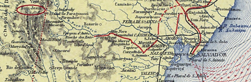
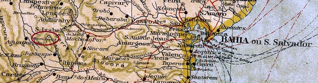
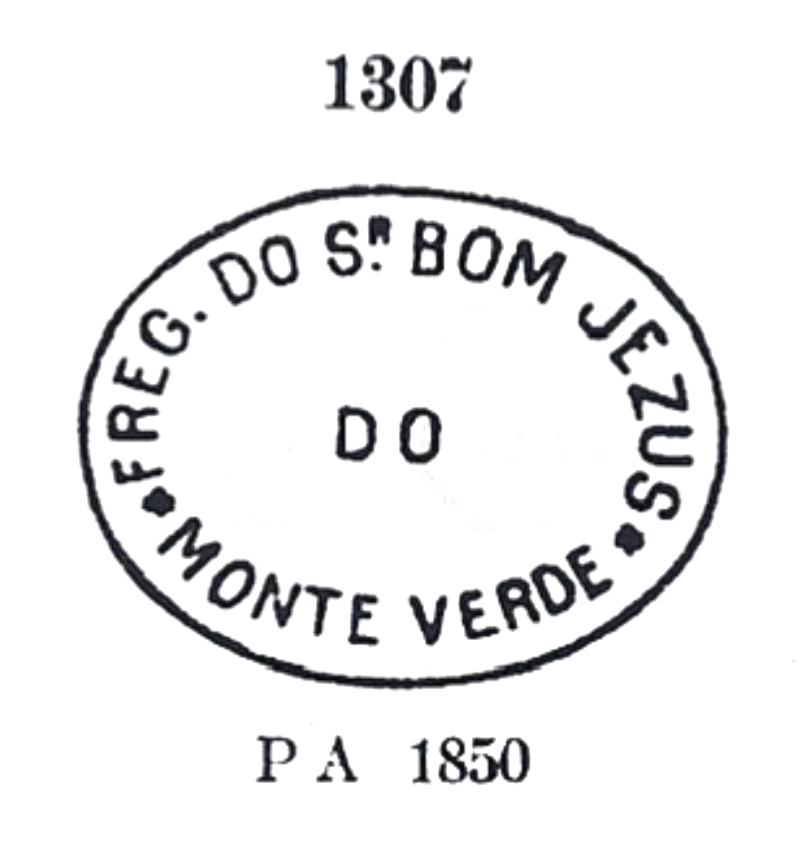
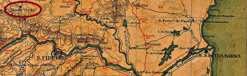
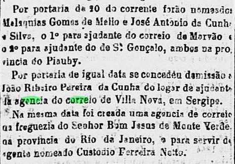
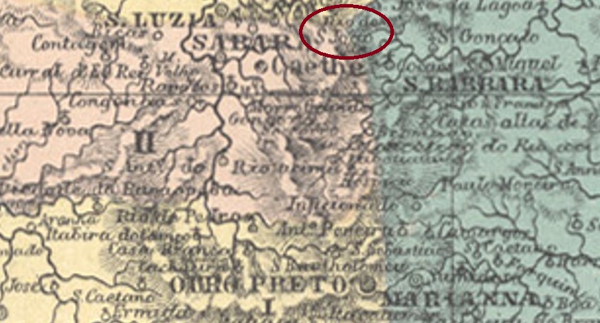
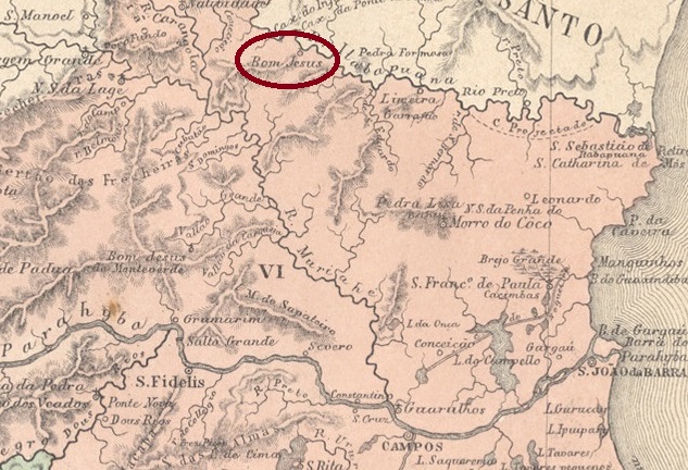
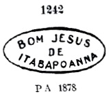
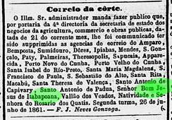
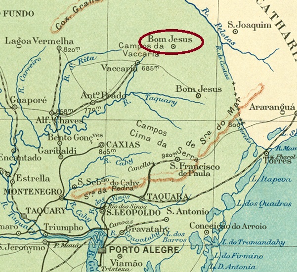
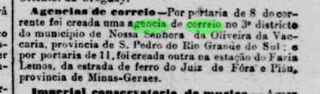
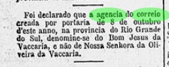
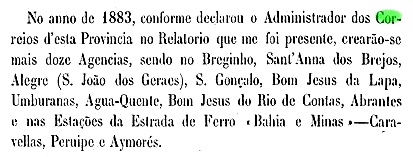
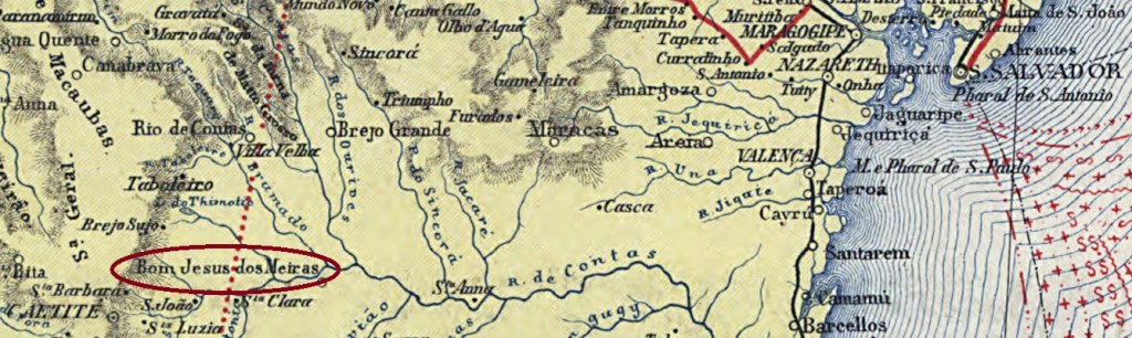
The Freguesia of Senhor Bom Jesus dos Meiras came into being in June 1869 and has its origin in the fazenda called Senhor Bom Jesus do Campo Seco, of the landowner Francisco de Sousa Meira. It was located on the west bank of the Rio do Antonio (a tributary of the Brumado) near the Vila of Caetité, 540 km southwest of the provincial capital Salvador da Bahia. The village rose to the status of Vila in June 1877 and has been the Município of Brumado since June 1931.Two dates of origin for the local post office were found. Reinhold Koester (Carimbologia V) writes October 1872 for it, while in the Directory of Imperial Post Offices (Tabella das Agencias do Correio do Imperio, Rio de Janeiro, 1885) the year 1878 can be read. A note in the regional press indicates that in July 1878 there was still no post office in operation locally:

Correio da Bahia, 02.08.1878

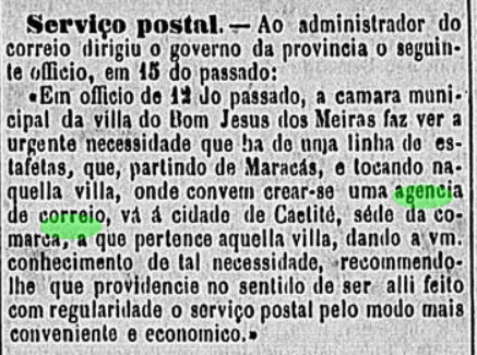
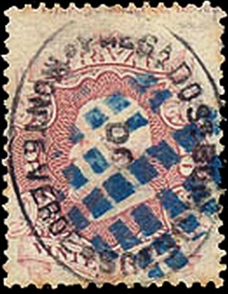
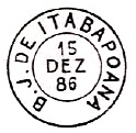
So far, no imperial postmark has been seen from this locality.

Estado da Bahia, 1913

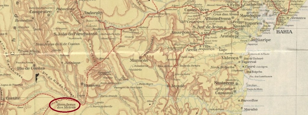
Die Freguesia von Senhor Bom Jesus dos Meiras entstand im Juni 1869 und hat ihren Ursprung in der Fazenda namens Senhor Bom Jesus do Campo Seco, des Großgrundbesitzers Francisco de Sousa Meira. Sie lag am Westufer des Rio do Antonio (ein Nebenfluss des Brumado) bei der Vila von Caetité, 540 km südwestlich der Provinzhauptstadt Salvador da Bahia. Der Ort stieg im Juni 1877 zur Vila auf und ist seit Juni 1931 der Município von Brumado.

Zwei Entstehungsdaten fürs örtliche Postamt wurden gefunden. Reinhold Koester (Carimbologia V) schreibt dafür den Oktober 1872, während im Verzeichnis der kaiserlichen Postämter (Tabella das Agencias do Correio do Imperio, Rio de Janeiro, 1885) das Jahr 1878 zu lesen ist. Eine Meldung der Regionalpresse deutet darauf hin, dass im Juli 1878 noch kein Postamt vor Ort in Betrieb war:

Correio da Bahia, 02.08.1878

Bisher war kein kaiserlicher Poststempel aus dieser Ortschaft zu sehen.

Categories
Carimbologia A-B

Bom Jesus do Rio de Contas, Bahia (BBA-0140)

Carta da Republica dos Estados Unidos do Brazil, 1892

Other names: Bom Jesus dos Limões, Anchieta, Piatã (1943)

The parish of Senhor Bom Jesus was established in May 1842 under the Vila of Minas do Rio de Contas and was located on the east bank of the Rio de Contas, 540 km west of the provincial capital Salvador da Bahia. The village rose to the status of Vila in July 1878, after which there were two changes in the place name: in June 1931 to Anchieta and in December 1943 to Piatã. This name is still valid today.

Reinhold Koester writes in Carimbologia V that the local post office was created in September 1882, which is also confirmed by the Directory of Imperial Post Offices (Tabella das Agencias do Correio do Imperio, Rio de Janeiro, 1885). On the other hand, a report of the Provincial President gives the year of creation as 1883:

Relatorio do Conselho Interino do Governo da Bahia, 1884

The last date could be that of the commissioning of the agency. A postmark was found for the 19th century: BBA-0140a (Coll. José A. Junges) is a double circle with the inscription BOM JESUS R.C. above and a star-shaped ornament below. The dates in the centre so far go from 1890 to 1897.

Mappa Geral do Brasil, 1911

Andere Namen: Bom Jesus dos Limões, Anchieta, Piatã (1943)

Die Pfarrei von Senhor Bom Jesus wurde im Mai 1842 unter der Vila von Minas do Rio de Contas errichtet und lag am Ostufer des Rio de Contas, 540 km westlich der Provinzhauptstadt Salvador da Bahia entfernt. Die Ortschaft stieg im Juli 1878 zur Vila, danach gab es zwei Änderungen im Ortsnamen: im Juni 1931 zu Anchieta und im Dezember 1943 zu Piatã. Dieser Name ist noch heute gültig.

Reinhold Koester schreibt in Carimbologia V, dass das örtliche Postamt im September 1882 entstanden ist, was auch vom Verzeichnis der kaiserlichen Postämter (Tabella das Agencias do Correio do Imperio, Rio de Janeiro, 1885) bestätigt wird. Dagegen nennt der Bericht des Provinzpräsidenten das Enstehungsjahr 1883:

Relatorio do Conselho Interino do Governo da Bahia, 1884

Letzter Termin könnte der von der Inbetriebnahme der Agentur sein. Ein Poststempel wurde für das 19. Jahrhundert gefunden: BBA-0140a (Samml. José A. Junges) ist ein Doppelkreis mit der Inschrift BOM JESUS R.C. oben und einem sternförmigen Ornament unten. Die Daten in der Mitte gehen bisher von 1890 bis 1897.

Categories
Carimbologia A-B

Bom Jesus do Monte Verde, Rio de Janeiro (BRJ-0205)

Atlas do Imperio do Brasil, 1868

Other names: Senhor Bom Jesus do Monte Verde, Monte Verde

See also Senhor Bom Jesus do Monte Verde (SRJ-0205)

Senhor Bom Jesus do Monte Verde (Our Lord, Kind Jesus of Green Mountain) was a freguesia of São Fidelis from November 1861, about 280 km northeast of the capital Rio de Janeiro. In May 1891, the village rose to become a vila called Monte Verde within its own município but lost political administrative autonomy in December 1929. Since then, Monte Verde has been a district in the município of Cambuci.

The local post office was established in July 1864, as reported by the Rio press:

Correio Mercantil/RJ, 25 July 1864

In his Catálogo de Carimbos Brasil-Império (S. Paulo, 1937, 1942) Paulo Ayres shows two early postmarks from this place. However, R. Koester in Carimbologia V considers the first of them (P.A. 1306) to be wrong. The other one (P.A. 1307) would then be SRJ-0205a, which was in use from the beginning until 1883:

SRJ-0205a (P.A. 1307)

However, the small letter A after FREG is missing in this cancel, as can be seen here:

1864ff (EB)

A mute cancellation used in conjunction with SRJ-0205a also dates from this period:

1866ff (RHM)

Then came BRJ-0205a, used from 1884 to 1891 and already seen in R. Koester’s Carimbologia V:

BRJ-0205a (RK) 1884-1891
Almanak Laemmert, 1892

Andere Namen: Senhor Bom Jesus do Monte Verde, Monte Verde

Siehe auch Senhor Bom Jesus do Monte Verde (SRJ-0205)

Senhor Bom Jesus do Monte Verde (Unser Herr, gütiger Jesus aus dem Grünen Berg) war ab November 1861 eine Freguesia von São Fidelis, die ca. 280 km nordöstlich der Hauptstadt Rio de Janeiro entfernt lag. Im Mai 1891 stieg der Ort zu einer Vila namens Monte Verde mit eigenem Município, verlor aber die politische Verwaltungsautonomie im Dezember 1929. Seitdem ist Monte Verde ein Distrikt im Município von Cambuci.

Das örtliche Postamt wurde im Juli 1864 ins Leben gerufen, wie die Presse aus Rio berichtete:

Correio Mercantil/RJ, 25.07.1864

In Catálogo de Carimbos Brasil-Império (S. Paulo, 1937, 1942) zeigt Paulo Ayres gleich zwei frühe Poststempel aus diesem Ort. Allerdings hält R. Koester in Carimbologia V den ersten davon (P.A. 1306) für falsch. Der andere (P.A. 1307) wäre dann SRJ-0205a, der vom Beginn an bis 1883 in Gebrauch war:

SRJ-0205a (P.A. 1307)

Allerdings fehlt in diesem Stempel der kleine Buchstabe A nach FREG, wie man hier sehen kann:

1864ff (EB)

Aus dieser Zeit stammt auch eine stumme Abstempelung, die in Verbindung zu SRJ-0205a benutzt wurde:

1866ff (RHM)

Danach kam BRJ-0205a, der von 1884 bis 1891 verwendet wurde und bereits in R. Koesters Carimbologia V zu sehen war:

BRJ-0205a (RK) 1884-1891
Categories
Carimbologia A-B

Bom Jesus do Amparo do Rio São João, Minas Gerais (BMG-0340)

Estado de Minas Geraes, 1910

Other names: Bom Jesus do Rio S. João, Bom Jesus do Amparo (1943)

The parish of Bom Jesus do Amparo do Rio São João was established in 1842 in the Município of Caeté, 120 km north of the provincial capital of Ouro Preto. In June 1858, the village changed as a freguesia to the Município of Santa Bárbara and in December 1943 as a district to the Município of Barão de Cocais, this time under the shortened place name Bom Jesus do Amparo. Ten years later came its rise as an independent município. The S. João River apparently disappeared from the map in the meantime, too.

The local post office was established in December 1881, as reported by the Rio press:

Jornal do Commercio/RJ, 29.12.1881

The only imperial postmark so far is BMG-0340a, which was already presented by R. Koester in Carimbologia V:

BMG-0340a (RK) 1888ff
Atlas do Imperio do Brasil, 1868

Andere Namen: Bom Jesus do Rio S. João, Bom Jesus do Amparo (1943)

Die Pfarrei von Bom Jesus do Amparo do Rio São João wurde 1842 im Município von Caeté errichtet und lag 120 km nördlich der Provinzhauptstadt Ouro Preto. Im Juni 1858 wechselte die Ortschaft als Freguesia zum Município von Santa Bárbara und im Dezember 1943 als Distrikt zum Município von Barão de Cocais, diesmal unter dem gekürzten Ortsnamen Bom Jesus do Amparo. Zehn Jahre später kam der Aufstieg als eigenständiger Município. Der Fluss S. João scheint inzwischen auch aus der Karte verschwunden zu sein.

Das örtliche Postamt wurde im Dezember 1881 ins Leben gerufen, wie die Presse aus Rio meldete:

Jornal do Commercio/RJ, 29.12.1881

Der bisher einzige kaiserliche Poststempel ist BMG-0340a und wurde bereits durch R. Koester in Carimbologia V vorgestellt:

BMG-0340a (RK) 1888ff
Categories
Carimbologia A-B

Bom Jesus de Itabapoanna, Rio de Janeiro (BRJ-0200)

Atlas do Imperio do Brasil, 1868

The Freguesia of Senhor Bom Jesus de Itabapoana was founded in November 1862 and was located on the south bank of the river Itabapoana in the Município of Itaperuna on the provincial border with Espírito Santo, 330 km northeast of the capital Rio de Janeiro. It was elevated to the status of vila in November 1892, but it returned as a district of Itaperuna between May 1892 and December 1938, before becoming an independent município again.

Two dates of origin for the local post office were found, as Nova Monteiro wrote in Administrações e Agencias Postaes do Brasil Imperio (Brasil Filatelico/RJ, 1934-5; Reprint SPP 1994-1999). Firstly, in October 1856, though here the place name is erroneously given as São (instead of Senhor) Bom Jesus de Itabapoanna. The agency closed in June 1861, as reported by the Rio Press:

Correio Mercantil, 29.06.1861

Nova Monteiro (op. cit.) reported the second post office opening as being in January 1868. Three postmarks were found for the Empire, all already shown by Paulo Ayres in Catálogo de Carimbos Brasil-Império (S. Paulo, 1937, 1942):

BRJ-0200a (P.A. 1242) 1868-1883ff, also in dark purple
BRJ-0200b (P.A. p. 120) 1879-1890, also in blue
BRJ-0200c (P.A. p. 145)
Almanak Laemmert, 1866

Die Freguesia von Senhor Bom Jesus de Itabapoana wurde im November 1862 gegründet und lag am Südufer des Flusses Itabapoana im Município von Itaperuna an der Provinzgrenze zu Espírito Santo, 330 km nordöstlich der Hauptstadt Rio de Janeiro entfernt. Der Aufstieg zur Vila erfolgte im November 1892. Dennoch fristete der Ort ein Dasein als Distrikt von Itaperuna zwischen Mai 1892 und Dezember 1938 wieder, bevor daraus wieder ein eigenständiger Município wurde.

Zwei Entstehungsdaten fürs örtliche Postamt wurden gefunden, wie Nova Monteiro in Administrações e Agencias Postaes do Brasil Imperio (Brasil Filatelico/RJ, 1934-5; Reprint SPP 1994-1999) schrieb. Erstmals im Oktober 1856, allerdings wird hier der Ortsname irrtümlich als São (statt Senhor) Bom Jesus de Itabapoanna angegeben. Die Agentur schloss im Juni 1861, wie die Rio-Presse berichtete:

Correio Mercantil, 29.06.1861

Nova Monteiro (op. cit.) meldete die zweite Postamtsentstehung zum Januar 1868. Drei Poststempel wurden fürs Kaiserreich gefunden, die alle bereits durch Paulo Ayres in Catálogo de Carimbos Brasil-Império (S. Paulo, 1937, 1942) gezeigt wurden:

BRJ-0200a (P.A. 1242) 1868-1883ff, auch in dunkelviolett
BRJ-0200b (P.A. S. 120) 1879-1890, auch in blau
BRJ-0200c (P.A. S. 145)
Categories
Carimbologia A-B

Bom Jesus da Vaccaria, Rio Grande do Sul (BRS-0040)

Briguiet: Estado do Rio Grande do Sul, 1923

Other names: Costa da Serra, Aparados da Serra, Bom Jesus (1948)

The district of Senhor Bom Jesus do Bomfim was founded in May 1876 in the Município of Vacaria, close to the provincial border with Santa Catarina, 250 km north of the provincial capital Porto Alegre. Three years later, the place became a curato and in July 1913 a vila. After that, the town’s name changed twice: in December 1944 to Aparados da Serra and in November 1948 to Bom Jesus, which is still current today.

The local post office was created in October 1887, according to the Rio press:

Jornal do Commercio/RJ, 12/10/1887

However, the place name was reported incorrectly. This error was corrected only two months later:

Gazeta de Noticias/RJ, 10.12.1887

The agency was closed in January 1892, and later reopened. So far, no imperial postmark has been found here either.

Google Maps

Andere Namen: Costa da Serra, Aparados da Serra, Bom Jesus (1948)

Der Distrikt von Senhor Bom Jesus do Bomfim wurde im Mai 1876 im Município von Vacaria gegründet und lag nah an der Provinzgrenze zu Santa Catarina, 250 km nördlich der Provinzhauptstadt Porto Alegre entfernt. Drei Jahre später wurde der Ort zu einem Curato und im Juli 1913 zu einer Vila erhoben. Danach änderte sich der Ortsname zweimal: im Dezember 1944 zu Aparados da Serra und im November 1948 zum heute noch aktuellen Bom Jesus.

Das örtliche Postamt wurde im Oktober 1887 ins Leben gerufen, wie die Presse aus Rio schrieb:

Jornal do Commercio/RJ, 12.10.1887

Allerdings wurde der Ortsname falsch mitgeteilt. Diesen Fehler korrigierte man erst zwei Monate später:

Gazeta de Noticias/RJ, 10.12.1887

Die Agentur wurde im Januar 1892 geschlossen, und eröffnete später wieder. Bisher wurde auch hier kein kaiserlicher Poststempel gefunden.

Categories
Carimbologia A-B

Bom Jesus da Lapa, Bahia (BBA-0135)

Villiers de l’Ile Adam: Carta (…) da Provincia da Bahia, 1848

Another name: Lapa (1931-1935)

The freguesia of Bom Jesus da Lapa was founded in 1874 on the east bank of the São Francisco River, 780 km west of the provincial capital Salvador da Bahia. It rose to the status of vila in September 1890 and to a town in August 1923. Between June 1931 and June 1935, the Município was simply called Lapa, then the original place name returned for good.

There had been a post office there since October 1883, as R. Koester writes in Carimbologia V. This is confirmed by the report of the Provincial Council of Government the following year:

Relatorio do Conselho Interino do Governo da Bahia, 1884

So far, no imperial postmark from Bom Jesus da Lapa has been seen.

Atlas do Imperio do Brasil, 1868

Anderer Name: Lapa (1931-1935)

Die Freguesia von Bom Jesus da Lapa wurde 1874 am Ostufer des Flusses São Francisco gegründet und lag 780 km westlich der Provinzhauptstadt Salvador da Bahia entfernt. Sie stieg im September 1890 zur Vila und im August 1923 zur Stadt auf. Zwischen Juni 1931 und Juni 1935 hieß der Município einfach Lapa, dann kehrte der ursprüngliche Ortsname endgültig zurück.

Ein Postamt gab es dort seit Oktober 1883, wie R. Koester in Carimbologia V schreibt. Das wird durch den Bericht des Provinziellen Regierungsrats im folgenden Jahr bestätigt:

Relatorio do Conselho Interino do Governo da Bahia, 1884

Bisher war kein kaiserlicher Poststempel aus Bom Jesus da Lapa zu sehen.

Categories
Carimbologia A-B

Bom Jesus da Gurgueia, Piauí (BPI-0040)

Villiers de l’Ile Adam: Carta (…) da Provincia do Piauhy, 1850

Other names: Buritizinho, Bom Jesus

Bom Jesus da (or also de/do) Gurgueia was a freguesia in the Município of Parnaguá from September 1838, located on the Gurgueia River, 600 km south of the later provincial capital Teresina. The village became a vila in December 1855, which today bears the shortened name Bom Jesus.

In the Directory of Imperial Post Offices (Tabella das Agencias do Correio do Imperio, Rio de Janeiro, 1885), one reads that there had been a post office there since 1881. However, a local postal agent was mentioned in the regional press as early as May of the previous year:

A Imprensa, 23.06.1880

So far, no imperial-era postmark has been seen for this place.

Atlas do Imperio do Brasil, 1868

Andere Namen: Buritizinho, Bom Jesus

Bom Jesus da (oder auch de/do) Gurgueia war ab September 1838 eine Freguesia im Município von Parnaguá, die am Fluss Gurgueia lag, 600 km südlich der späteren Provinzhauptstadt Teresina entfernt. Die Ortschaft wurde im Dezember 1855 eine Vila, die heute den gekürzten Namen Bom Jesus trägt.

Im Verzeichnis der kaiserlichen Postämter (Tabella das Agencias do Correio do Imperio, Rio de Janeiro, 1885) liest man, dass es dort seit 1881 ein Postamt gab. Allerdings wurde ein Postagent vor Ort schon im Mai des Vorjahres in der Regionalpresse genannt:

A Imprensa, 23.06.1880

Bisher wurde kein Poststempel der Kaiserzeit für diesen Ort gesehen.

Categories
Carimbologia A-B

Bom Jesus da Cachoeira Alegre, Minas Gerais (BMG-0335)

Almanak Laemmert, 1892

Another name: Bom Jesus da Cachoeira (1943)

Bom Jesus da Cachoeira Alegre (Good Jesus of the Happy Waterfall) was, from September 1887, a freguesia in the Município of S. Paulo do Muriaé, located 230 km southeast of the provincial capital Ouro Preto. This is how it has remained until today, although since 1923 the município has only been called Muriaé, and since December 1943 the freguesia has been shortened to Bom Jesus da Cachoeira.

The local post office is dated September 1889, a few weeks before the end of the Empire, as can be read in the postal bulletin (Boletim Postal) of the following month:

Boletim Postal No. 6, Oct. 1889

The first postmark is BMG-0335a (image from the internet): a double circle with the inscriptions BOM JESUS DA CACHA. ALEGRE above and (M) below. The only specimen so far bears a date from 1890 in the centre.

Estado de Minas Geraes, 1910

Anderer Name: Bom Jesus da Cachoeira (1943)

Bom Jesus da Cachoeira Alegre (Guter Jesus des Fröhlichen Wasserfalls) war ab September 1887 eine Freguesia im Município von S. Paulo do Muriaé, die 230 km südöstlich der Provinzhauptstadt Ouro Preto entfernt lag. Und so ist es bis heute geblieben, wobei der Município seit 1923 lediglich Muriaé heißt, und die Freguesia seit Dezember 1943 den Namen zu Bom Jesus da Cachoeira abgekürzt bekam.

Das örtliche Postamt ist vom September 1889, also von wenigen Wochen vor dem Ende des Kaiserreichs, wie im Postbulletin (Boletim Postal) des Folgemonats zu lesen ist:

Boletim Postal Nr. 6, Okt. 1889

Der erste Poststempel ist BMG-0335a (Abb. aus dem Internet): ein Doppelkreis mit den Inschriften BOM JESUS DA CACHA. ALEGRE oben und (M) unten. Das bisher einzige Exemplar trägt ein Datum aus 1890 in der Mitte.

Categories
Carimbologia A-B

Bom Jardim, Rio Grande do Sul (BRS-0035)

Estado do Rio Grande do Sul, 1891

Another name: Ivoti (1938)

The parish of S. Pedro do Bom Jardim was founded in November 1867 in the Município of S. Leopoldo, 55 km north of the provincial capital Porto Alegre. In 1938, the place was renamed as the District of Ivoti. In September 1959, the district changed to the newly established Município of Estância Velha. Since October 1964, Ivoti has been an independent Município.

The village post office was established in January 1883, as reported in the press from the capital:

A Folha Nova/RJ 15.01.1883

The imperial postmark is BRS-0035a (Coll. FM): a double circle with the inscription BOM JARDIM – letter J being much longer than the others – below is an ornament in lozenge. The dates in the middle are from 1886 so far.

colonias.heuser.pro.br

Anderer Name: Ivoti (1938)

Die Pfarrei von S. Pedro do Bom Jardim wurde im November 1867 im Município von S. Leopoldo gegründet und lag 55 km nördlich der Provinzhauptstadt Porto Alegre. 1938 wurde der Ort als Distrikt von Ivoti umbenannt. Im September 1959 wechselte der Distrikt zum neu gegründeten Município von Estância Velha. Seit Oktober 1964 ist Ivoti ein eigenständiger Município.

Das örtliche Postamt wurde im Januar 1883 ins Leben gerufen, wie die Presse aus der Hauptstadt berichtete:

A Folha Nova/RJ 15.01.1883

Der kaiserliche Poststempel ist BRS-0035a (Samml. FM): ein Doppelkreis mit der Inschrift BOM JARDIM – wobei Buchstabe J deutlich länger als die anderen ist – unten ist ein Ornament in Raute. Die Daten in der Mitte kommen bisher aus 1886.