Categories
Carimbologia A-B

Boa Vista, Maranhão (BMA-0050)

Atlas do Imperio do Brasil, 1868

Text update of March 4, 2024

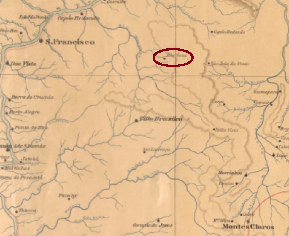
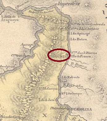
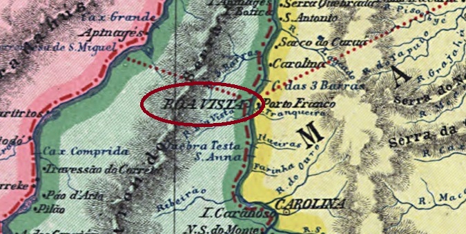
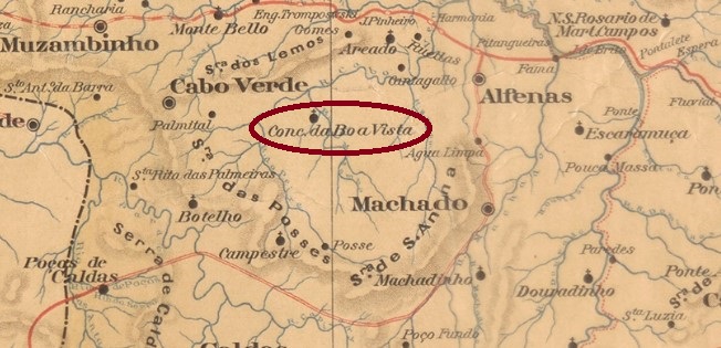
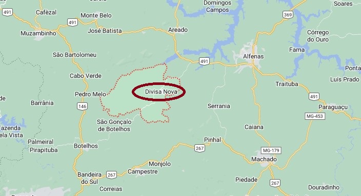
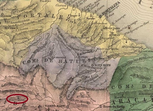
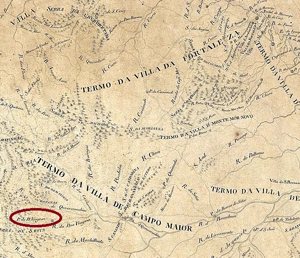
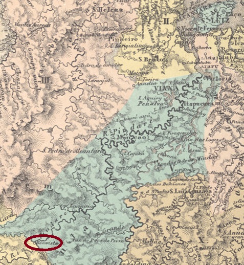
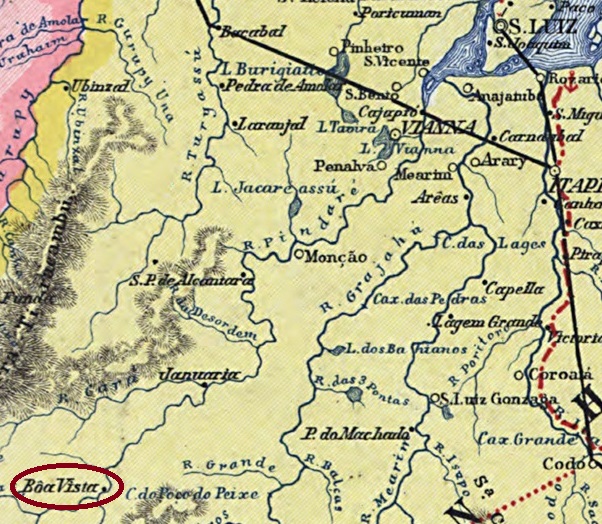
In the imperial province of Maranhão, there were at least three villages called Boa Vista. This was a small settlement belonging to the Vila of Monção, located on the west bank of the Pindaré River, 350 km southwest of the provincial capital São Luís. The place was much more important at that time than it is today, due to the agricultural colony of S. Pedro de Alcantara there was a lot of shipping traffic along the Pindaré. Boa Vista became a district around 1890, changing to the município of Santa Luzia in December 1959. Since November 1994, the village has been a rural suburb in the município of Alto Alegre do Pindaré.

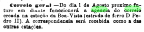
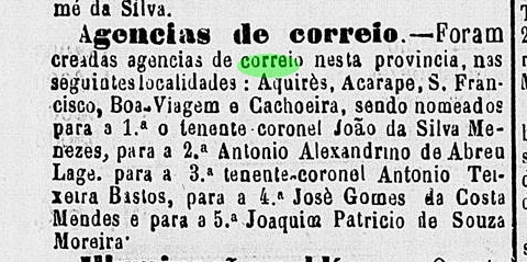
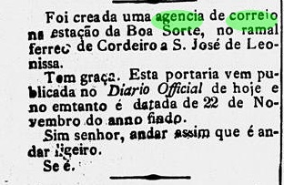
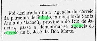
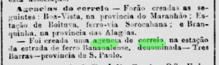
According to the Rio Press, there was a post office there from February 1889:

Jornal do Commercio/RJ, 01.03.1889

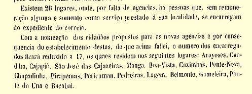
However, there was already postal services on site in 1875, carried out by volunteers, as can be read in the report of the provincial president from February of that year.

Relatorio do Presidente da Provincia, February 1875 (p. 42)

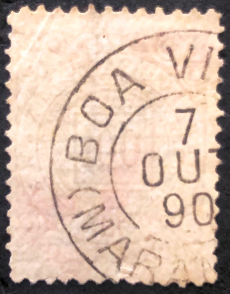
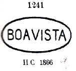
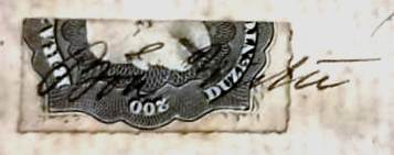
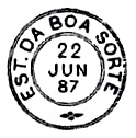
The oldest postmark so far from Boa Vista is BMA-0050a (image: Felipe Piccinini):

BMA-0050a (FP) 1890
Crata da Republica dos Estados Unidos do Brazil, 1892

Textaktualisierung am 4. März 2024

In der kaiserlichen Provinz Maranhão soll es mindestens drei Ortschaften gegeben haben, die Boa Vista hießen. Diese war eine kleine Siedlung, die der Vila von Monção gehörte und am Westufer des Flusses Pindaré lag, 350 km südwestlich der Provinzhauptstadt São Luís entfernt. Der Ort war damals wesentlich wichtiger als heute, denn durch die Landwirtschafts-Kolonie S. Pedro de Alcantara bestand auch regen Schiffsverkehr entlang des Pindarés. Boa Vista wurde ca. 1890 ein Distrikt, der im Dezember 1959 zum Município von Santa Luzia wechselte, seit November 1994 ist die Ortschaft ein ländlicher Vorort im Município von Alto Alegre do Pindaré.

Wie aus der Rio-Presse hervorgeht, gab es dort ein Postamt ab Februar 1889:

Jornal do Commercio/RJ, 01.03.1889

Allerdings gab es bereits 1875 Postdienste vor Ort, von Ehrenamtlichen durchgeführt, wie im Bericht des Provinzpräsidenten im Februar d. Js. zu lesen ist.

Relatorio do Presidente da Provincia, Februar 1875 (S. 42)

Der bisher älteste Poststempel aus Boa Vista ist BMA-0050a (Abb. Felipe Piccinini):

BMA-0050a (FP) 1890
Categories
Carimbologia A-B

Boa Vista (train station/Bahnhof), Rio de Janeiro (BRJ-0190)

Estrada de Ferro Central do Brasil, 1890

Another name: Engenheiro Passos (1894)

Boa Vista station was inaugurated in June 1873 by the E.F. D. Pedro II railway company (São Paulo line) in the Município of Resende, just before the provincial border with São Paulo, 200 km west of the capital Rio de Janeiro. The railway line went to the E.F. Central do Brasil in 1889 and from 1975 until its closure in 1996 it belonged to Rede Ferroviária Federal S.A. (estacoesferroviarias.com.br). In 1894 the station was renamed Engenheiro Francisco Pereira Passos. The name commemorates the engineer and politician (1836-1913) who undertook extensive urban redevelopment as mayor of Rio de Janeiro (1902-1906).

Pereira Passos, painting by Eliseu Visconti (1866-1944), Palácio da Cidade/RJ

The area around the station became the district of Engenheiro Passos in September 1952. The station building was restored in 2020 and now stands as an empty tourist attraction next to the noisy highway.

Ca. 1920 (estacoesferroviarias.com.br)
2021 (Photo: Felipe Medeiros, estacoesferroviarias.com.br)

The station post office had existed since 1873, as reported in the capital’s press:

Jornal do Commercio, 31/07/1873

The first station postmark is BRJ-0190a, already presented by Paulo Ayres in Catálogo de Carimbos Brasil-Império (S. Paulo, 1937, 1942) under No. 1241:

BRJ-0190a (P.A. 1241) 1873ff

Paulo Ayres also shows us the seal stamp BRJ-0190b, unfortunately without further information:

BRJ-0190b (P.A. p. 144)

From the Fuad Ferreira Fo. collection comes a handwritten cancellation from there:

1877 (FF)
Estações (…) do Rio de Janeiro, São Paulo e Minas Geraes, 1880

Anderer Name: Engenheiro Passos (1894)

Der Bahnhof Boa Vista wurde im Juni 1873 durch die Bahngesellschaft E.F. D. Pedro II (São Paulo-Linie) eingeweiht und lag im Município von Resende, kurz vor der Provinzgrenze zu São Paulo, 200 km westlich der Hauptstadt Rio de Janeiro entfernt. Die Bahnlinie ging 1889 zur E.F. Central do Brasil und von 1975 bis zur Stilllegung 1996 gehörte sie der Rede Ferroviária Federal S.A. (estacoesferroviarias.com.br). 1894 wurde der Bahnhof zu Engenheiro Francisco Pereira Passos umbenannt. Der Name erinnert an den Ingenieur und Politiker (1836-1913), der sich als Prefeito von Rio de Janeiro (1902-1906) eine ausführliche Stadtsanierung vornahm.

Pereira Passos, Gemälde von Eliseu Visconti (1866-1944), Palácio da Cidade/RJ

Das Gebiet um den Bahnhof wurde der Distrikt von Engenheiro Passos im September 1952. Das Bahnhofsgebäude wurde 2020 auswendig restauriert und nun steht als leere touristische Attraktion neben der lauten Autobahn.

Ca. 1920 (estacoesferroviarias.com.br)
2021 (Foto: Felipe Medeiros, estacoesferroviarias.com.br)

Das Bahnhofspostamt gab es seit 1873, wie die Hauptstadtpresse berichtete:

Jornal do Commercio, 31.07.1873

Das erste Bahnhofsstempel ist BRJ-0190a, der bereits durch Paulo Ayres in Catálogo de Carimbos Brasil-Império (S. Paulo, 1937, 1942) unter Nr. 1241vorgestellt wurde:

BRJ-0190a (P.A. 1241) 1873ff

Paulo Ayres zeigt uns auch den Siegelstempel BRJ-0190b, leider ohne weitere Information:

BRJ-0190b (P.A. S. 144)

Aus der Sammlung Fuad Ferreira Fo. kommt auch eine handschriftliche Entwertung von dort:

1877 (FF)
Categories
Carimbologia A-B

Boa Vista do Tremedal, Minas Gerais (BMG-3215)

Mappa Geral do Brasil, 1911

Other names: N. Sra. da Graça do Tremedal, Tremedal, Monte Azul (1938)

See also Tremedal (TMG-3215)

The parish of Nossa Senhora da Graça de Tremedal was established in July 1868 in the Município of Rio Pardo, located on the east bank of the Tabuleiro River, 750 km north of the provincial capital of Ouro Preto. In November 1878, it became the villa of Boa Vista de Tremedal, which rose to a town in October 1887. In September 1923, the municipality name was simplified to Tremedal, and the Município has been called Monte Azul (Blue Mountain) since December 1938.

The local post office came into being in November 1881, as can be read in the Rio press:

Jornal do Commercio/RJ, 12.11.1881

The only old postmark from this locality seen so far is BMG-3215b (Coll. José A. Junges): A double circle where one can read only …DO TREMENDAL (sic), dated 1905 inside.

Atlas do Imperio do Brasil, 1868

Andere Namen: N. Sra. da Graça do Tremedal, Tremedal, Monte Azul (1938)

Siehe auch Tremedal (TMG-3215)

Die Pfarrei von Nossa Senhora da Graça de Tremedal wurde im Juli 1868 im Município von Rio Pardo errichtet und lag am Ostufer des Flusses Tabuleiro, 750 km nördlich der Provinzhauptstadt Ouro Preto entfernt. Im November 1878 wurde daraus die Villa von Boa Vista de Tremedal, die im Oktober 1887 zur Stadt aufstieg. Im September 1923 wurde der Gemeindename zu Tremedal vereinfacht, der Município heißt seit Dezember 1938 Monte Azul (Blauer Berg).

Das örtliche Postamt entstand im November 1881, wie man in der Rio-Presse lesen kann:

Jornal do Commercio/RJ, 12.11.1881

Der einzige bisher gesichtete alte Stempel von diesem Ort ist BMG-3215b (Samml. José A. Junges): Ein Doppelkreis, auf dem nur …DO TREMENDAL (sic) zu lesen ist, innen 1905 datiert.

Categories
Carimbologia A-B

Boa Vista (Montes Claros), Minas Gerais (BMG-0310)

Estado de Minas Geraes, 1910

See also Santo Antonio da Boa Vista (SMG-4055)

Santo Antonio da Boa Vista was since July 1850 a district of the municipality of São João da Ponte, situated over 600 km north of the provincial capital Ouro Preto. Since then, it has changed to two other municipalities: in November 1877 to Sant’Anna de Contendas, and in September 1901 to Vila Brasília, before returning to São João da Ponte in December 1943.

According to Paula Sobrinho (História Postal de Minas Gerais, Belo Horizonte, 1997), the local post office was created in January 1883. No postal cancel of the Empire could be safely identified until now.

Google Maps

Siehe auch Santo Antonio da Boa Vista (SMG-4055)

Santo Antonio da Boa Vista war ab Juli 1850 ein Distrikt im Município von São João da Ponte, der über 600 km nördlich der Provinzhauptstadt Ouro Preto entfernt lag. Seitdem wechselte die Ortschaft zweimal zu anderen Gemeinden: im November 1877 zu Sant’Anna de Contendas und im September 1901 zu Vila Brasília, und kehrte zum ursprünglichen Município von São João da Ponte im Dezember 1943 endgültig zurück.

Wie Paula Sobrinho in seiner História Postal de Minas Gerais (Belo Horizonte, 1997) berichtet, entstand das örtliche Postamt im Januar 1883. Keine postalische Abstempelung von dort konnte bisher sicherlich identifiziert werden.

Categories
Carimbologia A-B

Boa Vista (do Tocantins), Goiás (BGO-0025)

Atlas do Imperio do Brasil, 1868

Another name: Tocantinópolis (1943)

N. Sra. da Conceição da Boa Vista was an arraial belonging to the Vila of Carolina, located directly on the west bank of the river Tocantins, 1260 km (!) north of the provincial capital Goyaz (today Goiás Velho). The place rose twice to the status of Vila (1834 and 1852) and in between (1840) was again demoted as a district. Since July 1858, Boa Vista has been a town, which has been called Tocantinópolis since 1943 and has belonged to the new federal state of Tocantins since 1988.

Two dates of origin for the local post office were found here. First in March 1829, as Nova Monteiro writes in Administrações e Agencias Postaes do Brasil Imperio (Brasil Filatelico/RJ, 1934-5; Reprint SPP 1994-1999). Then again in 1869, as listed in the Directory of Imperial Post Offices (Tabella das Agencias do Correio do Imperio, Rio de Janeiro, 1885). Here again, no imperial postmark has been seen so far.

Carta da Republica dos Estados Unidos do Brasil, 1892

Anderer Name: Tocantinópolis (1943)

N. Sra. da Conceição da Boa Vista war ein Arraial, der der Vila von Carolina gehörte und direkt am Westufer des Flusses Tocantins lag, 1260 km (!) nördlich der Provinzhauptstadt Goyaz (heute Goiás Velho). Der Ort stieg zweimal zur Vila (1834 und 1852) auf und wurde zwischendurch (1840) wieder als Distrikt degradiert. Seit Juli 1858 ist Boa Vista eine Stadt, die seit 1943 Tocantinópolis heißt und seit 1988 dem neuen Bundessstaat Tocantins angehört.

Hier wurden zwei Entstehungsdaten fürs örtliche Postamt gefunden. Erstmals im März 1829, wie Nova Monteiro in Administrações e Agencias Postaes do Brasil Imperio (Brasil Filatelico/RJ, 1934-5; Reprint SPP 1994-1999) schreibt. Dann wieder 1869, wie im Verzeichnis der kaiserlichen Postämter (Tabella das Agencias do Correio do Imperio, Rio de Janeiro, 1885) aufgelistet. Auch hier wurde bisher kein kaiserlicher Poststempel gesehen.

Categories
Carimbologia A-B

Boa Vista, Minas Gerais (BMG-0795)

Estado de Minas Geraes, 1910

Another name: Divisa Nova (1923)

N. Sra. da Conceição da Boa Vista was originally an arraial of the Villa of Caldas, located close to the east bank of the Muzambo River, 420 south of the provincial capital Ouro Preto. The place went as a district to the Município of Alfenas in July 1864, which changed to the Município of Cabo Verde in August 1911 under the name of Conceição da Boa Vista do Cabo Verde. In September 1923, it was renamed Divisa Nova (New Border). Since December 1938, Divisa Nova has been an independent Município.

The local post office was created in November 1873, as both Paula Sobrinho in História Postal de Minas Gerais (Belo Horizonte, 1997) and R. Koester in Carimbologia XIII write. Here, too, the imperial postmark is still to come.

Google Maps

Anderer Name: Divisa Nova (1923)

N. Sra. da Conceição da Boa Vista war ursprünglich ein Arraial der Villa von Caldas, der nah am Ostufer des Flusses Muzambo lag, 420 südlich der Provinzhauptstadt Ouro Preto entfernt. Der Ort ging als Distrikt zum Município von Alfenas im Juli 1864, der im August 1911 unter dem Namen Conceição da Boa Vista do Cabo Verde zum Município von Cabo Verde wechselte. Im September 1923 erfolgte die Umbenennung zu Divisa Nova (Neue Grenze). Seit Dezember 1938 ist Divisa Nova ein eigenständiger Município.

Das örtliche Postamt wurde im November 1873 ins Leben gerufen, wie sowohl Paula Sobrinho in História Postal de Minas Gerais (Belo Horizonte, 1997) als auch R. Koester in Carimbologia XIII schreiben. Auch hier lässt das kaiserliche Poststempel auf sich warten.

Categories
Carimbologia A-B

Boa Viagem (train station/Bahnhof), Pernambuco (BPE-0105)

Atlas do Imperio do Brasil, 1868

Boa Viagem (Good Journey) station was inaugurated in February 1858 by the E.F. de Recife ao São Francisco railway company and was located at the Recife suburb of the same name, 10 km south of the city centre. The railway line went to the Great Western Railway Co. in 1901 and to Rede Ferroviária do Nordeste in 1950. From 1975 until its closure in 1996, it belonged to Rede Ferroviária Federal S.A. (estacoesferroviarias.com.br). Boa Viagem has been an administrative district (Distrito Administrativo) of the metropolis of Recife since July 1960. The station was later demolished to make way for the airport metro station; this was inaugurated in March 2009.

In the Directory of Imperial Post Offices (Tabella das Agencias do Correio do Imperio, Rio de Janeiro, 1885), the station post office is listed as having been established in 1875, which is confirmed by the postal report (Relatorio Postal) for 1887. No imperial postmark has been seen from here either.

Carta Corographica da Provincia de Pernambuco, 1880

Der Bahnhof Boa Viagem (Gute Reise) wurde im Februar 1858 durch die Bahngesellschaft E.F. de Recife ao São Francisco eingeweiht und lag am gleichnamigen Vorort Recifes, 10 km südlich der Stadtmitte. Die Bahnlinie ging 1901 zum Great Western Railway Co. und 1950 zur Rede Ferroviária do Nordeste. Von 1975 bis zur Stilllegung 1996 gehörte sie der Rede Ferroviária Federal S.A. (estacoesferroviarias.com.br). Boa Viagem ist seit Juli 1960 ein Verwaltungsdistrikt (Distrito Administrativo) der Metropole Recife. Später wurde der Bahnhof abgerissen, um Platz für die U-Bahnstation Aeroporto (Flughafen) zu machen; diese wurde im März 2009 eingeweiht.

Im Verzeichnis der kaiserlichen Postämter (Tabella das Agencias do Correio do Imperio, Rio de Janeiro, 1885) wird das Bahnhofpostamt mit Entstehungsjahr 1875 aufgelistet, was durch den Postbericht (Relatorio Postal) für 1887 bestätigt wird. Auch von hier wurde bisher kein kaiserlicher Poststempel gesehen.

Categories
Carimbologia A-B

Boa Viagem, Ceará (BCE-0050)

Villiers de l’Ile Adam: Carta (…) da Provincia do Ceará, 1849

Another name: Cavalo Morto 

The place was called Cavalo Morto (Dead Horse) in the 18th century, after a stream nearby, where the horse of the first settler arrived and fell down dead. In November 1862, it became the freguesia called N. Sra. da Boa Viagem, which belonged to the Vila of Quixeramobim and was 220 km southwest of the provincial capital, Fortaleza. Two years later, it was promoted to vila. Between May 1931 and December 1936, Boa Viagem was downgraded as a district of Quixeramobim, then regained vila status and has been a city since December 1938. The stream is now also called Boa Viagem.

Two dates of origin for the local post office have been found. The first one was in June/July 1872, according to the regional press:

Cearense/04.07.1872

Then again in January 1881, as R. Koester writes in Carimbologia V. This second date is not confirmed, as the Boa Viagem post office was listed in the 1880 Directory of Imperial Post Offices (Guia Postal do Império do Brazil, Rio de Janeiro, 1880). No imperial postmark from Boa Viagem has been seen so far.

Capitania do Ceara, 1818

Der Ort hieß im 18. Jahrhundert Cavalo Morto (Totes Pferd), nach einem Bach der Gegend, an dessen Ufer das Pferd des ersten Siedlers kam und tot umfiel. Im November 1862 wurde daraus die Freguesia namens N. Sra. da Boa Viagem, die der Vila von Quixeramobim angehörte und 220 km südwestlich der Provinzhauptstadt Fortaleza lag. Zwei Jahre später erfolgte der Aufstieg zur Vila. Zwischen Mai 1931 und Dezember 1936 wurde Boa Viagem als Distrikt von Quixeramobim herabgestuft, erlangte dann wieder den Villa-Status und ist seit Dezember 1938 eine Stadt. Der Bach heißt inzwischen auch Boa Viagem.

Zwei Entstehungszeitpunkte fürs örtliche Postamt wurden gefunden. Erstmals Juni/Juli 1872, wie aus der Regionalpresse hervorgeht:

Cearense/04.07.1872

Dann wieder im Januar 1881, wie R. Koester in Carimbologia V schreibt. Dieses zweite Datum ist nicht bestätigt, da das Postamt Boa Viagem im Verzeichnis der Kaiserlichen Postämter 1880 (Guia Postal do Império do Brazil, Rio de Janeiro, 1880) aufgelistet wurde. Bisher war kein kaiserliches Poststempel aus Boa Viagem zu sehen.

Categories
Carimbologia A-B

Boa Sorte (train station/Bahnhof), Rio de Janeiro (BRJ-0185)

Almanak Laemmert, 1892

Boa Sorte (Good Luck) station was inaugurated around 1885 by the E.F. de Cantagallo railway company (Cordeiro-S. José de Leonissa Branch) and was in the Município of Cantagalo, 250 km northeast of the capital Rio de Janeiro. The railway line went to the E.F Macahe e Campos in 1888, and from 1890 until its closure in 1967 it belonged to the E.F. Leopoldina. Today the rails and station building have disappeared (estacoesferroviarias.com.br). The settlement around the station grew slowly and has been a district of Cantagallo since 1924.

Although the station post office was created in November 1883, the official notice about it did not appear until January 1884:

Gazeta da Tarde, 12.1.1884

The first station postmark is BRJ-0185a, used at least until 1888 and was already made known through Paulo Ayres in Catálogo de Carimbos Brasil-Império (S. Paulo, 1937, 1942):

BRJ-0185a (P.A. p. 120)

Reinhold Koester also showed a seal cancel in Carimbologia V, unfortunately without further information:

BRJ-0185b (RK)
IBGE, 1958

Der Bahnhof Boa Sorte (Viel Glück) wurde um 1885 durch die E.F. de Cantagallo-Bahngesellschaft (Abzweigung Cordeiro-S. José de Leonissa) eingeweiht und lag im Município von Cantagalo, 250 km nordöstlich der Hauptstadt Rio de Janeiro entfernt. Die Bahnlinie ging 1888 an die E.F Macahe e Campos, von 1890 bis zur Stilllegung 1967 gehörte sie der E.F. Leopoldina. Heute sind Schienen und Bahnhofsgebäude verschwunden (estacoesferroviarias.com.br). Die Siedlung um den Bahnhof wuchs langsam und ist seit 1924 ein Distrikt von Cantagalo.

Das Bahnhofspostamt wurde zwar im November 1883 ins Leben gerufen, die amtliche Bekanntmachung darüber erschien aber erst im Januar 1884:

Gazeta da Tarde, 12.1.1884

Der erste Bahnhofs-Poststempel ist BRJ-0185a, der zumindest bis 1888 gebraucht wurde und bereits durch Paulo Ayres in Catálogo de Carimbos Brasil-Império (S. Paulo, 1937, 1942) bekannt ist:

BRJ-0185a (P.A. S. 120)

Reinhold Koester zeigte außerdem im Carimbologia V einen Siegelstempel, leider ohne weitere Information:

BRJ-0185b (RK)
Categories
Carimbologia A-B

Boa Morte, Rio de Janeiro (BRJ-0183)

Almanak Laemmert, 1892

See also São José da Boa Morte (SRJ-0948) and Subaio (SRJ-0968)

Another name: São José da Boa Morte

São José da Boa Morte (= of the good death) was a freguesia in the Município of Santo Antonio de Sá from August 1834, located about 100 km northeast of Rio de Janeiro. At that time, Santo Antonio de Sá was already in decline due to a long and devastating malaria epidemic. After its end in November 1868, São José passed to the newly founded Município of Sant’Anna de Macacu, which was called Sant’Anna de Japuíba from December 1898. Since March 1938, this município has been called Cachoeiras de Macacu; of which São José is a rural suburb whose main attraction is the ruins of the old chapel.

In 2019 (Photo: Claudio Menezes)

More recently, a postmark inscribed only BOA MORTE has appeared on a D. Pedro issue from 1866; an evidence that a post office was in operation locally at the time:

BRJ-0183a (Coll. Claudio Coelho) ca. 1870

As there were no other reports of a post office in Boa Morte, this postmark could be from the neighbouring village of Subaio, whose post office opened in 1868 or 1869 (see SRJ-0968), but of which no postmark has been seen before. Subaio was a small parish of this freguesia, which did not really need a postal agency, but was the residence of a political leader of the region…

According to Paulo Novaes (agenciaspostais.com.br), there was a São José da Boa Morte post office from June 1887 to September 1914, but this agency was identical to the one in the neighbouring municipality of Subaio, as can be seen from the Rio press:

Gazeta de Noticias, 21 July 1887

For postmarks with São José da Boa Morte, see SRJ-0948.

Villers de l’Ile Adam: Carta (…) da Provincia do Rio de Janeiro, 1850

Siehe auch São José da Boa Morte (SRJ-0948) und Subaio (SRJ-0968)

Anderer Name: São José da Boa Morte

São José da Boa Morte (= des guten Todes) war ab August 1834 eine Freguesia im Município von Santo Antonio de Sá, die ca. 100 km nordöstlich von Rio de Janeiro lag. Zu dieser Zeit befand sich Santo Antonio de Sá durch eine lange und verheerende Malaria-Epidemie bereits in einem Niedergang, der nicht mehr aufzuhalten war. Nach dessen Ende im November 1868 ging São José zum neu gegründeten Município von Sant’Anna de Macacu über, der ab Dezember 1898 Sant’Anna de Japuíba hieß. Seit März 1938 trägt dieser Município den Namen Cachoeiras de Macacu; davon ist São José ein ländlicher Vorort, dessen Hauptattraktion die Ruinen der alten Kapelle sind.

2019 (Foto: Claudio Menezes)

In letzter Zeit ist ein Poststempel nur mit der Inschrift BOA MORTE auf einer D. Pedro-Ausgabe aus 1866 aufgetaucht; ein Beweis dafür, dass damals ein Postamt vor Ort in Betrieb war:

BRJ-0183a (Samml. Claudio Coelho) ca. 1870

Da sonst nirgends über ein Postamt in Boa Morte berichtet wurde, könnte dieser Stempel aus dem Nachbarort Subaio sein, dessen Postamt 1868 oder 1869 eröffnet wurde (siehe SRJ-0968), von dem aber bisher kein Poststempel zu sehen war. Subaio war eine kleine Pfarrei dieser Freguesia, die eigentlich keine Postagentur gebraucht hätte, doch der Wohnsitz eines politischen Führers der Region war…

Laut Paulo Novaes (agenciaspostais.com.br) gab es ein Postamt São José da Boa Morte vom Juni 1887 bis September 1914. Allerdings war diese Agentur identisch mit der in der Nachbargemeinde Subaio, wie aus der Rio-Presse zu entnehmen ist:

Gazeta de Noticias, 21. Juli 1887

Für Poststempel mit São José da Boa Morte siehe SRJ-0948.