Categories
Carimbologia A-B

Benevente, Espírito Santo (BES-0195)

Briguiet: Estado do Espirito Santo, 1923

Other names: Reritiba, Anchieta

See also Anchieta (AES-0020)

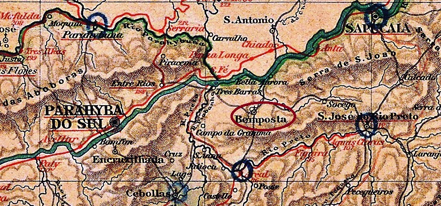
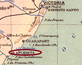
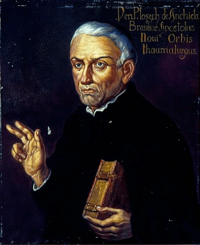
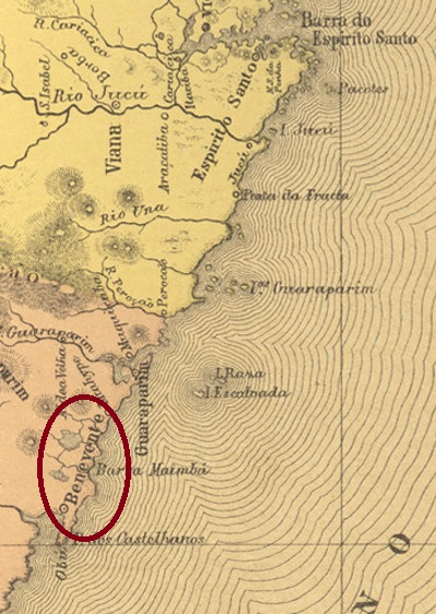
This settlement, which is very old by Brazilian standards, was established around 1570 on the delta of the Benevente River, 80 km south of the later provincial capital Vitória. The original place name was Reritiba, which means many oysters in the Tupi language. In January 1759, the Vila of N. Sra. da Assumpção de Benevente was proclaimed there, which has been the town of Anchieta since August 1887, but this name apparently took a long time to catch on. This is to commemorate the Spanish Father José de Anchieta (1534-1597), who is buried there and has been a saint of the Catholic Church since 2014:

Painting by Oscar P. da Silva (1867-1939), Museu Paulista da USP

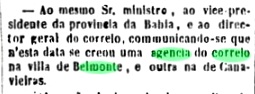
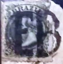
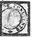
The local post office was established in October 1831, when the town was still called Benevente, as Nova Monteiro writes in Administrações e Agencias Postaes do Brasil Imperio (Brasil Filatelico/RJ, 1934-5; reprint SPP 1994-1999). The first postmark has not yet been found, the second is BES-0195b and has already been shown by. R. Koester in Carimbologia IV:

BES-0195b (RK) 1883ff-1884ff

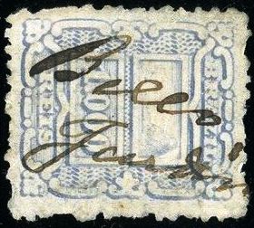
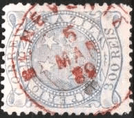
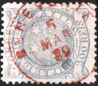
It was followed by BES-0195c (fig. from the internet) A double circle with the inscription BENEVENTE on top, which also exists in red, and which shows inner dates between 1886 and 1889.

BES-0195c (image from the internetB)

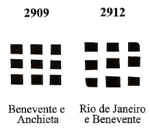
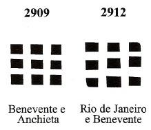
Ttwo mute postmarks were also used, which are registered in the Mute Cancellations of the Brazil Empire / Carimbos Mudos do Brasil Império (Brazil Philatelic Association, Rio de Janeiro, 2000) under nos. 2909 and 2912:

BPA 2909 and 2912

For postmarks with Anchieta see AES-0020.

Atlas do Imperio do Brasil, 1868

Andere Namen: Reritiba, Anchieta

Siehe auch Anchieta (AES-0020)

Diese für brasilianische Verhältnisse sehr alte Siedlung entstand bereits um 1570 am Delta des Flusses Benevente, 80 km südlich der späteren Provinzhauptstadt Vitória entfernt. Der erste Ortsname war Reritiba, was in der Tupi-Sprache viele Austern bedeutet. Im Januar 1759 wurde dort die Vila von N. Sra. da Assumpção de Benevente ausgerufen, die seit August 1887 zwar die Stadt Anchieta ist, aber dieser Name hat offenbar lange gebraucht, um sich durchzusetzen. Damit soll an den spanischen Pater José de Anchieta (1534-1597) erinnert, der dort begraben liegt und seit 2014 ein Heiliger der katholischen Kirche ist:

Gemälde v. Oscar P. da Silva (1867-1939), Museu Paulista da USP

Das örtliche Postamt entstand im Oktober 1831, als der Ort noch Benevente hieß, wie Nova Monteiro in Administrações e Agencias Postaes do Brasil Imperio (Brasil Filatelico/RJ, 1934-5; Reprint SPP 1994-1999) schreibt. Der erste Poststempel wurde noch nicht gefunden, der zweite ist BES-0195b und wurde bereits durch. R. Koester in Carimbologia IV gezeigt:

BES-0195b (RK) 1883ff-1884ff

Ihm folgte BES-0195c (Abb. aus dem Internet) Ein Doppelkreis mit der Inschrift BENEVENTE oben, den es auch in rot gibt, und der inneren Daten zwischen 1886 und 1889 aufweist.

BES-0195c (Abb. aus dem Internet)

Zwei stumme Poststempel wurden auch gebraucht, die im Mute Cancellations of the Brazil Empire / Carimbos Mudos do Brasil Império (Brazil Philatelic Association, Rio de Janeiro, 2000) unter den Nr. 2909 und 29129 registriert sind:

BPA 2909 und 2912

Für kaiserliche Poststempel mit Anchieta siehe AES-0020.

Categories
Carimbologia A-B

Bemposta, Rio de Janeiro (BRJ-0170)

Atlas do Imperio do Brasil, 1868

The Freguesia de N. Sra. da Conceição da Bemposta was founded in October 1855 in the Municipio of Parahyba do Sul, 120 km north of the capital Rio de Janeiro. The place changed as a district to the Município of Entre-Rios in December 1938, which was renamed Três Rios two weeks later. Bemposta is said to have been the name of a fazenda in the area.

Nova Monteiro writes in Administrações e Agencias Postaes do Brasil Imperio (Brasil Filatelico/RJ, 1934-5; Reprint SPP 1994-1999) that there had been a post office there since December 1856, which is confirmed by the Directory of Imperial Post Offices (Tabella das Agencias do Correio do Imperio, Rio de Janeiro, 1885). However, seven months later, the Rio press again reported the creation of a postal agency there.

Diario do Rio de Janeiro, 21.07.1857

Four postmarks were found for the Imperial period. BRJ-0170a is certainly the oldest among them, it exists dated to 1863, and is known through P. Ayres (Catálogo de Carimbos Brasil-Império, S. Paulo, 1937, 1942) under no. 1238:

BRJ-0170a (P.A. 1238) 1857-1863

We also know its successor BRJ-0170b, used between c. 1866 to 1883ff, through P. Ayres (op. cit.), this time with no. 1239:

BRJ-0170b (P.A. 1239) 1866ff-1883ff

The double circle BRJ-0170c was shown by R. Koester in Carimbologia IV:

BRJ-0170c (RK) 1878-1887

And the seal BRJ-0170d was also presented by P. Ayres:

BRJ-0170d (P.A. p.144)
Almanak Laemmert, 1892

Die Freguesia de N. Sra. da Conceição da Bemposta wurde im Oktober 1855 gegründet und lag im Municipio von Parahyba do Sul, 120 km nördlich der Hauptstadt Rio de Janeiro entfernt. Der Ort wechselte im Dezember 1938 als Distrikt zum Município von Entre-Rios, der zwei Wochen später zu Três Rios umbenannt wurde. Bemposta soll der Name einer Fazenda der Gegend gewesen sein.

Nova Monteiro schreibt in Administrações e Agencias Postaes do Brasil Imperio (Brasil Filatelico/RJ, 1934-5; Reprint SPP 1994-1999), es gab dort ein Postamt seit Dezember 1856, was durch das Verzeichnis der kaiserlichen Postämter (Tabella das Agencias do Correio do Imperio, Rio de Janeiro, 1885) bestätigt wird. Allerdings meldete sieben Monate später die Presse aus Rio nochmals die Entstehung einer Postagentur dort.

Diario do Rio de Janeiro, 21.07.1857

Vier Poststempel wurden für die Kaiserzeit gefunden. BRJ-0170a ist sicher der älteste davon, ihn gibt es bis 1863 datiert, er ist durch P. Ayres (Catálogo de Carimbos Brasil-Império, S. Paulo, 1937, 1942) mit Nr. 1238 bekannt:

BRJ-0170a (P.A. 1238) 1857-1863

Auch sein Nachfolger BRJ-0170b, der zwischen ca. 1866 bis 1883ff verwendet wurde, kennen wir durch P. Ayres (op. cit.), diesmal unter Nr.1239:

BRJ-0170b (P.A. 1239) 1866ff-1883ff

Der Doppelkreis BRJ-0170c wurde seinerseits durch R. Koester in Carimbologia IV vorgestellt:

BRJ-0170c (RK) 1878-1887

Und den Siegel BRJ-0170d zeigte uns ebenfalls P. Ayres:

BRJ-0170d (P.A. S.144)
Categories
Carimbologia A-B

Bemfica (train station/Bahnhof), Minas Gerais (BMG-0280)

Estrada de Ferro Central do Brasil, 1890

Bemfica station was inaugurated in February 1877 by the E.F. Dom Pedro II Railway Company (Central Line) on the west bank of the Paraibuna River, in the Município of Juiz de Fora, 200 km south of the provincial capital Ouro Preto. The railway line went to E.F. Central do Brasil in 1889 and belonged to Rede Ferroviária Federal S.A. from 1975 until its closure in 1996 (estacoesferroviarias.com.br). Today the rails are still there, the station building serves as a workroom for the goods train company MRS Logística S.A.

1921 (Photo: Jorge A. Ferreira in estacoesferroviarias.com.br)
2010 (Photo: Jorge A. Ferreira in estacoesferroviarias.com.br)

The settlement around the station continued to grow and became a district in August 1911; since September 1968 it has been a quartier of Juiz de Fora.

Two dates of origin for the station post office have been found. The first was in February 1877 – shortly after the inauguration of the station, according to the Rio press:

O Globo/RJ 23.02.1877

The second date was in July 1881, as both the postal report (Relatorio Postal) of 1886 and Paula Sobrinho write in História Postal de Minas Gerais (Belo Horizonte, 1997). Paulo Novaes (agenciaspostais.com.br) suggests this is when the station jurisdiction changed from the province of Rio de Janeiro to Minas Gerais.

Two postmarks have been found from this station: the first one, BMG-0280a, was in use from the beginning, having been already presented by Paulo Ayres in Catálogo de Carimbos Brasil-Império (S. Paulo, 1937, 1942) under no. 1237:

BMG-0280a (P.A. 1237) 1877ff

Its successor BMG-0280b was introduced by R. Koester in Carimbologia IV:

BMG-0280b (RK) 1885-1893
Estações (…) do Rio de Janeiro, São Paulo e Minas Geraes, 1880

Der Bahnhof Bemfica wurde im Februar 1877 durch die E.F. Dom Pedro II Bahngesellschaft (Hauptlinie) eingeweiht und lag am Westufer des Flusses Paraibuna, im Município von Juiz de Fora, 200 km südlich der Provinzhauptstadt Ouro Preto entfernt. Die Bahnlinie ging 1889 zur E.F. Central do Brasil und gehörte vom 1975 bis zur Stilllegung 1996 der Rede Ferroviária Federal S.A. (estacoesferroviarias.com.br). Heute sind die Schienen noch da, das Bahnhofsgebäude dient als Arbeitsraum für die Güterzugsgesellschaft MRS Logística S.A.

1921 (Foto: Jorge A. Ferreira in estacoesferroviarias.com.br)
2010 (Foto: Jorge A. Ferreira in estacoesferroviarias.com.br)

Die Siedlung um den Bahnhof wuchs weiter und wurde im August 1911 zum Distrikt; seit September 1968 ist sie ein Stadtteil von Juiz de Fora.

Zwei Entstehungstermine fürs Bahnhofspostamt wurden gefunden. Erstmals im Februar 1877 – also kurz nach der Bahnhofseinweihung, wie die Presse aus Rio mitteilte:

O Globo/RJ 23.02.1877

Der zweite Termin fand im Juli 1881, wie sowohl im Postbericht (Relatorio Postal) von 1886 zu lesen ist, als auch Paula Sobrinho im História Postal de Minas Gerais (Belo Horizonte, 1997) schreibt. Paulo Novaes (agenciaspostais.com.br) meint, dieser wäre der Zeitpunkt, als die Bahnhofszuständigkeit von der Provinz Rio de Janeiro zu Minas Gerais wechselte.

Aus zwei Poststempel aus diesem Bahnhof wurden gefunden: der erste, BMG-0280a, war von Beginn an in Verwendung und wurde bereits durch Paulo Ayres in Catálogo de Carimbos Brasil-Império, (S. Paulo, 1937, 1942) unter der Nr. 1237 vorgestellt:

BMG-0280a (P.A. 1237) 1877ff

Sein Nachfolger BMG-0280b wurde durch R. Koester in Carimbologia IV bekannt gemacht:

BMG-0280b (RK) 1885-1893
Categories
Carimbologia A-B

Belmonte, Bahia (BBA-0125)

Villiers de l’Ile Adam: Carta (…) da Provincia da Bahia, 1848

Another name. S. Pedro do Rio Grande

This was the former settlement called Arraial de S. Pedro do Rio Grande, which originated about 1710 on the southern shore of the Jequitinhonha estuary on the Atlantic Ocean, 720 km south of the provincial capital Salvador da Bahia. In April 1718, it became the Freguesia de N. Sra. do Carmo de Belmonte, which became a vila in 1764 and the town of Belmonte in May 1895.

Belmonte Post Office, ca. 1975 (IBGE)

Two dates of origin have been found for the Imperial Post Office, although a third, earlier date could be added. For the first time in June 1852, as Nova Monteiro writes in Administrações e Agencias Postaes do Brasil Imperio (Brasil Filatelico/RJ, 1934-5; Reprint SPP 1994-1999). This is confirmed by the Rio press:

Diario do Rio de Janeiro/03.07.1852

Then again in July 1858, as noted in Koester’s Carimbologia IV, and also listed in the Directory of Imperial Post Offices (Tabella das Agencias do Correio do Imperio, Rio de Janeiro, 1885). The third date could have been before 1851, according to a text by Milton P. de Azevedo in Brasil Filatélico No. 129.

The oldest postmark so far is BBA-0125b (image from the Internet), used between 1885 and 1901: a double circle with the inscription BELMONTE at the top. It was followed by BBA-0125c (image from the Internet), which can already be a republican none, as the inner date of 1896 shows. In this double circle, in addition to BELMONTE at the top, one also reads (BAHIA) at the bottom.

Atlas do Imperio do Brasil, 1868

Anderer Name. S. Pedro do Rio Grande

Diese war die frühere Siedlung namens Arraial de S. Pedro do Rio Grande, die ca. 1710 am Südufer der Jequitinhonha-Mündung am Atlantik entstanden ist, 720 km südlich der Provinzhauptstadt Salvador da Bahia. Im April 1718 wurde daraus die Freguesia de N. Sra. do Carmo de Belmonte, die 1764 eine Vila und im Mai 1895 die Stadt Belmonte wurde.

Postamt Belmonte, ca. 1975 (IBGE)

Zwei Entstehungszeitpunkte wurden fürs kaiserliche Postamt gefunden, wobei ein dritter, früher Termin dazu kommen könnte. Erstmals im Juni 1852, wie Nova Monteiro in Administrações e Agencias Postaes do Brasil Imperio (Brasil Filatelico/RJ, 1934-5; Reprint SPP 1994-1999) schreibt. Das wird durch die Presse aus Rio bestätigt:

Diario do Rio de Janeiro/03.07.1852

Dann wieder im Juli 1858, wie im Koesters Carimbologia IV vermerkt, und auch im Verzeichnis der kaiserlichen Postämter (Tabella das Agencias do Correio do Imperio, Rio de Janeiro, 1885) aufgelistet ist. Der dritte Termin könnte vor 1851 stattgefunden haben, laut einem Text vom Milton P. de Azevedo in Brasil Filatélico Nr. 129.

Der bisher älteste Poststempel ist BBA-0125b (Abb. aus dem Internet), der zwischen 1885 und 1901 verwendet wurde: ein Doppelkreis mit der Inschrift BELMONTE oben. Ihm folgte BBA-0125c (Abb. aus dem Internet), der schon republikanisch kein kann, wie das innere Datum aus 1896 zeigt. In diesem Doppelkreis liest man außer BELMONTE oben auch (BAHIA) unten.

Categories
Carimbologia A-B

Bello Monte, Alagoas (BAL-0030)

Atlas do Imperio do Brasil, 1868

Another name: Lagoa Funda

The parish of N. Sra. do Bom Conselho da Lagoa Funda was created in July 1885, located on the north bank of the São Francisco River in the Município of Traipu, 210 km west of the provincial capital Maceió. The village became the vila of Bello Monte in June 1886, and in May 1893 was again elevated as a district from the Município of Traipu, only to become an independent município again in July 1895.

As Aldo Cardoso writes in Contribuição para a História dos Correios de Alagoas (Maceió, 1969), there was a post office there since July 1869. So far, no imperial postmark from Bello Monte has been seen.

Arthur D. Ribeiro: Estado de Alagoas, 1923

Anderer Name: Lagoa Funda

Die Pfarrei von N. Sra. do Bom Conselho da Lagoa Funda entstand im Juli 1885, sie lag am Nordufer des Flusses São Francisco im Município von Traipu, 210 km westlich der Provinzhauptstadt Maceió. Der Ort wurde im Juni 1886 zur Vila von Bello Monte, im Mai 1893 wieder als Distrikt vom Município von Traipu, um im Juli 1895 wieder als eigenständiger Município erhoben zu werden.

Wie Aldo Cardoso in Contribuição para a História dos Correios de Alagoas (Maceió, 1969) schreibt, gab es dort ein Postamt seit Juli 1869. Bisher war kein kaiserlicher Poststempel aus Bello Monte zu sehen.

Categories
Carimbologia A-B

Bello Jardim, Pernambuco (BPE-0090)

Carta Corographica da Provincia de Pernambuco, 1880

Other names: Capim, Caropotós

This settlement originated around 1854 with the name Capim (Grasses), it was located on the west bank of the river Ipojuca, 190 km west of the provincial capital Recife. In 1881, it became the Arraial of N. Sra. da Conceição do Bello Jardim, belonging to the Vila of Brejo da Madre de Deus. The place became a vila in July 1909 and a town in September 1928.

The local post office was established in July 1882, as reported in the Rio Press:

Gazeta de Noticias/RJ, 25/07/1882

There was no imperial postmark from Bello Jardim yet. A handwritten cancellation appeared on the internet on an issue from 1888:

1888 (EB)
Arthur D. Ribeiro: Estado de Pernambuco, 1924

Andere Namen: Capim, Caropotós

Diese Siedlung entstand ca. 1854 mit dem Namen Capim (Gräser), sie lag am Westufer des Flusses Ipojuca, 190 km westlich der Provinzhauptstadt Recife entfernt. 1881 wurde daraus der Arraial von N. Sra. da Conceição do Bello Jardim, der der Vila von Brejo da Madre de Deus gehörte. Der Ort wurde im Juli 1909 zu einer Vila und im September 1928 eine Stadt.

Das örtliche Postamt entstand im Juli 1882, wie in der Rio Presse zu lesen war:

Gazeta de Noticias/RJ, 25.07.1882

Noch war kein kaiserlicher Poststempel aus Bello Jardim zu sehen. Eine handschriftliche Entwertung tauchte im Internet auf einer Ausgabe aus 1888 auf:

1888 (EB)
Categories
Carimbologia A-B

Bella Vista, São Paulo (BSP-0150)

Arthur D. Ribeiro: Estado de São Paulo, 1924

Other names: Santo Antonio do Rio Feio, Porangaba (1919)

See also Rio Feio (RSP-1333)

Rio Feio means Ugly River, so it does not wonder that other names followed for this locality. Santo Antonio do Rio Feio was founded in April 1880 as a district of the municipality of Tatuhy (now written Tatuí), situated about 170 km west from São Paulo. It changed the toponym for the first time in February 1885 to Bela Vista (= Beautiful Sight, probably from the river perspective), and for the second time in November 1919 to Porangaba, which in the tupi-guarani language means “The Beauty”. Since December 1927 has Porangaba an own municipality.

An Indian legend calls porangaba all plants capable to make humans more beautiful, such as the Cordia salicifolia, also known as chá-de-bugre (= Indian Tea) or …porangaba (see above).

Photo: Stephanie Weege-Susa

According to the Imperial Mail Register (Tabella das Agencias do Correio do Império) of 1885, a post office was created in Rio Feio in 1881, which is confirmed by the regional press:

Jornal da Tarde, 09.04.1881

No imperial cancel from this locality was found to date.

Google Maps

Andere Namen: Santo Antonio do Rio Feio, Porangaba (1919)

Siehe auch Rio Feio (RSP-1333)

Santo Antonio do Rio Feio wurde im April 1880 als ein Distrikt des Município von Tatuhy (heute Tatuí geschrieben) gegründet, etwa 170 km westlich von São Paulo entfernt. Der Ortsname wechselte erstmals im Februar 1885 zu Bela Vista (= Schöne Aussicht, womöglich aus der Flussperspektive) und zum zweiten Mal im November 1919 zu Porangaba, was in der tupi-guarani Indianersprache so viel wie „Die Schönheit“ bedeutet. Seit 1927 ist Porangaba als Município unabhängig.

Eine Indianerlegende nennt porangaba alle Pflanzen, die die Menschen schöner machen können, so wie die Cordia salicifolia, auch chá-de-bugre (= Indianertee) genannt, oder auch … porangaba (siehe oben)

Foto: Stephanie Weege-Susa

Laut Verzeichnis der kaiserlichen Postämter (Tabella das Agencias do Correio do Império) von 1885 entstand das Postamt in Rio Feio in 1881, was durch die Regionalpresse bestätigt wird:

Jornal da Tarde, 09.04.1881

Bisher wurde kein Stempel der Kaiserzeit mit dem Ortsnamen Bella Vista gefunden.

Categories
Carimbologia A-B

Bella Vista, Goiás (BGO-0020)

Carta da Republica dos Estados Unidos do Brazil, 1892

Other names: Sussuapara, Bela Vista de Goiás

Sussuapara was the name of a small river at the mouth of which a small settlement was established in 1866. In March 1880, it became the Freguesia of N. Sra. da Piedade da Bella Vista, which belonged to the Município of Bomfim and was 200 km southeast of the provincial capital of Goyaz (now Goiás Velho). The village continued to grow and in June 1896 became a vila, which was named Suçuapara (in a new spelling) in December 1943 and has been the Município of Bela Vista de Goiás since July 1953. Suçuapara is the indigenous name for the South American swamp deer:

Blastocerus dichotomus, Illiger 1815 (Photo: Jonathan Wilkins, CC BY-SA 3.0)

A local post office existed from December 1882, as reported by the provincial official press:

Correio Official de Goyaz, 03.03.1883

So far, no imperial postmark could be assigned to this locality with certainty.

Carta da Provincia de Goyaz, 1875

Andere Namen: Sussuapara, Bela Vista de Goiás

Sussuapara hieß ein kleiner Fluss, an dessen Mündung ins Piracanjuba eine kleine Siedlung anno 1866 entstanden ist. Im März 1880 wurde daraus die Freguesia von N. Sra. da Piedade da Bella Vista, die dem Município von Bomfim gehörte und 200 km südöstlich der Provinzhauptstadt Goyaz (heute Goiás Velho) entfernt lag. Der Ort wuchs weiter und wurde im Juni 1896 zu einer Vila, die im Dezember 1943 Suçuapara (in neuer Schreibweise) genannt wurde und seit Juli 1953 der Município von Bela Vista de Goiás ist. Suçuapara ist der indigene Name für den südamerikanischen Sumpfhirsch:

Blastocerus dichotomus, Illiger 1815 (Foto: Jonathan Wilkins, CC BY-SA 3.0)

Ein örtliches Postamt gab es ab Dezember 1882, wie die provinzielle Amtspresse berichtete:

Correio Official de Goyaz, 03.03.1883

Bisher konnte kein kaiserlicher Poststempel dieser Ortschaft mit Sicherheit zugeordnet werden.

Categories
Carimbologia A-B

Bella Joanna (train station/Bahnhof), Rio de Janeiro (BRJ-0160)

Almanak Laemmert, 1892

The Bella Joanna (Beautiful Joanna) railway station was inaugurated in August 1885 by the E.F. Leopoldina railway company (Sumidouro Branch), and located on the east bank of the Paquequer River in the Município of Carmo, 170 km northeast of the capital Rio de Janeiro. From June 1890, the area belonged to the Vila of Sumidouro. The railway line was operated until 1967, but today the rails are disappeared, and the station building has been demolished (estacoesferroviarias.com.br). Bella Joanna was the name of a fazenda in the area.

Photo: Amarildo Mayrink (estacoesferroviarias.com.br)

The station post office was created in November 1886, as reported by the capital’s press:

Gazeta de Noticias, 13/11/1886

Two postmarks were found for the 19th century. BRJ-0160a has already been made known by R. Koester in Carimbologia IV:

BRJ-0160a (RK) 1887-1893

Paulo Ayres (Catálogo de Carimbos Brasil-Império, S. Paulo, 1937, 1942) showed us BRJ-0160b:

BRJ-0160b (P.A. p. 145)
agenciaspostais.com.br

Der Bahnhof Bella Joanna (Schöne Johanna) wurde im August 1885 durch die Bahngesellschaft E.F. Leopoldina (Sumidouro Abzweigung) eingeweiht und lag am Ostufer des Flusses Paquequer im Município von Carmo, 170 km nordöstlich der Hauptstadt Rio de Janeiro entfernt. Ab Juni 1890 gehörte das Areal der Vila von Sumidouro. Die Bahnlinie wurde bis 1967 betrieben, heute sind die Schienen weg, das Bahnhofsgebäude wurde abgerissen (estacoesferroviarias.com.br). Bella Joanna hieß eine Fazenda in der Gegend.

Foto: Amarildo Mayrink (estacoesferroviarias.com.br)

Das Bahnhofspostamt wurde im November 1886 ins Leben gerufen, wie die Hauptstadtpresse berichtete:

Gazeta de Noticias, 13.11.1886

Zwei Poststempel wurden für den 19. Jahrhundert gefunden. BRJ-0160a wurde bereits durch R. Koester in Carimbologia IV bekannt gemacht:

BRJ-0160a (RK) 1887-1893

Paulo Ayres (Catálogo de Carimbos Brasil-Império, S. Paulo, 1937, 1942) zeigte uns BRJ-0160b:

BRJ-0160b (P.A. S. 145)
Categories
Carimbologia A-B

Belem (train station/Bahnhof), São Paulo (BSP-0141)

Cia. Sorocabana e Ytuana, 1898

Another name: Francisco Morato (1954)

Belem station was inaugurated in February 1867 by the São Paulo Railway (main line) and was located on the east bank of the Juqueri River in the Município of Jundiahy, 45 km north of the provincial capital of São Paulo. The railway line changed hands in 1946 to the E.F. de Santos a Jundiaí and in 1975 to the Rede Ferroviaria Federal S.A. (estacoesferroviarias.com.br). Since 1992 it has been operated by the Cia. Paulista de Trens Metropolitanos (CPTM).

The area around the station went to Franco da Rocha Município in December 1948 as a district called Francisco Morato. Francisco Morato (1868-1948) was a lawyer, politician, and historian from Piracicaba. He also gave his name to the railway station (1954) and the newly created Município (February 1964).

Wikimedia

As the regional press reported, there was a station post office there from December 1879:

Correio Paulistano, 27.12.1879

However, it was closed again within five years:

Correio Paulistano, 06.05.1884

The imperial station postmark was the French type BSP-0141a (Coll. Fuad Ferreira Fo.): a double circle with the inscription EST. DE BELEM at the top and the star between brackets at the bottom. The only specimen so far is dated 1882 in the centre. There is also a cancel by letters on the same item:

1882 (FF)
Estrada de Ferro Central do Brasil, 1890

Anderer Name: Francisco Morato (1954)

Der Bahnhof Belem wurde im Februar 1867 durch die Bahngesellschaft São Paulo Railway (Hauptlinie) eingeweiht und lag am Ostufer des Flusses Juqueri im Município von Jundiahy, 45 km nördlich der Provinzhauptstadt São Paulo entfernt. Die Bahnlinie wechselte 1946 zur E.F. de Santos a Jundiaí und 1975 zur Rede Ferroviaria Federal S.A. (estacoesferroviarias.com.br). Seit 1992 wird sie von der Cia. Paulista de Trens Metropolitanos (CPTM) betrieben.

Das Gebiet um den Bahnhof ging im Dezember 1948 als ein Distrikt namens Francisco Morato zum Município von Franco da Rocha. Francisco Morato (1868-1948) war ein Jurist, Politiker und Historiker aus Piracicaba. Er wurde ebenfalls Namensgeber für den Bahnhof (1954) und den neu gegründeten Município (Februar 1964).

Wikimedia

Wie die Regionalpresse berichtete, gab es dort ein Bahnhofpostamt ab Dezember 1879:

Correio Paulistano, 27.12.1879

Dieses wurde allerdings binnen fünf Jahren wieder geschlossen:

Correio Paulistano, 06.05.1884

Der Poststempel des Bahnhofs war der französische Typus BSP-0141a (Samml. Fuad Ferreira Fo.): ein Doppelkreis mit der Inschrift EST. DE BELEM oben und dem Stern zwischen Klammern unten. Das bisher einzige Exemplar ist 1882 in der Mitte datiert. Am gleichen Objekt befindet sich auch ein Entwerterstempel:

1882 (FF)