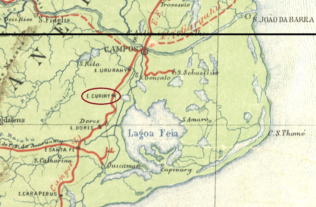
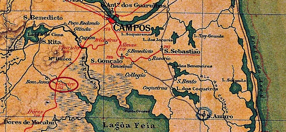
Guriry railway station was opened in 1875 by the E.F. Macaé e Campos railway company (Coastal Line) in the municipality of Campos, 270 km northeast of the capital Rio de Janeiro. The railway line was transferred to E.F. Leopoldina in 1887 and belonged to Rede Ferroviária Federal S.A. (estacoesferroviarias.com.br) from 1975 until it was closed in 1996. Today, the tracks are still there, but the station building was demolished long ago. In Brazil, Guriri is the name given to a type of palm tree that grows on sandy soil.
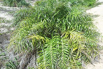
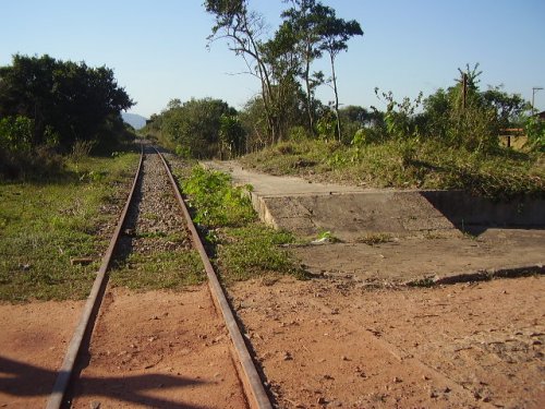
In July 2008 (photo: Ricardo Quintero de Matos, on estacoesferroviarias.com.br)Allagoptera arenaria (photo: Thiago MTB, CC BY-SA 3.0)
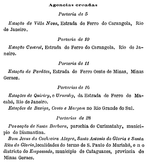
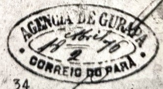
According to the postal bulletin (Boletim Postal), there had been a post office there since September 1889:
Boletim Postal No. 6, October 1889
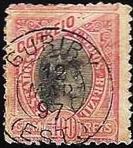
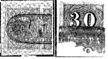
The oldest postmark to date is GRJ-0592a (fig. agenciaspostais.com.br):
GRJ-0592a (PN) 1894-1897Almanak Laemmert, 1892
Outra grafia: Quiriry
A estação ferroviária de Guriry foi inaugurada em 1875 pela E.F. Macaé e Campos (Linha do Litoral) no município de Campos, 270 km a nordeste da capital Rio de Janeiro. A linha ferroviária passou para a E.F. Leopoldina em 1887 e pertenceu à Rede Ferroviária Federal S.A. (estacoesferroviarias.com.br) de 1975 até ao seu encerramento em 1996. Hoje, os trilhos ainda existem, mas o edifício da estação foi demolido há muito tempo. Guriri é o nome dado no Brasil a uma espécie de palmeira que cresce em solo arenoso.
Em julho de 2008 (Foto: Ricardo Quintero de Matos, em estacoesferroviarias.com.br)Allagoptera arenaria (Foto: Thiago MTB, CC BY-SA 3.0)
Conforme consta no Boletim Postal, havia uma agência dos correios no local desde setembro de 1889:
Boletim Postal nº 6, outubro de 1889
O carimbo postal mais antigo até agora é o GRJ-0592a (fig. agenciaspostais.com.br):
GRJ-0592a (PN) 1894-1897agenciaspostais.com.br
Andere Schreibweise: Quiriry
Der Bahnhof Guriry wurde 1875 von der Eisenbahngesellschaft E.F. Macaé e Campos (Küstenlinie) im Gebiet des Município de Campos, 270 km nordöstlich der Hauptstadt Rio de Janeiro, eröffnet. Die Bahnlinie ging 1887 an die E.F. Leopoldina über und gehörte von 1975 bis zur Stilllegung im Jahr 1996 zur Rede Ferroviária Federal S.A. (estacoesferroviarias.com.br). Heute sind die Gleise noch vorhanden, das Bahnhofsgebäude wurde jedoch längst abgerissen. Guriri nennt man in Brasilien eine Palmensorte, die auf Sandboden wächst.
Im Juli 2008 (Foto: Ricardo Quintero de Matos, auf estacoesferroviarias.com.br)Allagoptera arenaria (Foto: Thiago MTB, CC BY-SA 3.0)
Wie aus dem Postbulletin (Boletim Postal) hervorgeht, gab es dort ein Postamt seit September 1889:
Boletim Postal Nr. 6, Oktober 1889
Der bisher älteste Poststempel ist GRJ-0592a (Abb. agenciaspostais.com.br):
Villiers de l’Ile Adam: Carta (…) das Provincias do Grão Pará e Alto Amazonas, 1850
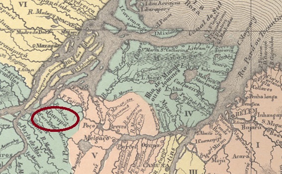
The Freguesia de Santo Antonio do Gurupá was founded directly as a Vila on the south bank of the Amazon back in 1639. The 350 km to the east as the crow flies to the capital Belém turn into 450 km by boat (a journey of almost 30 hours) or 970 km by car. Gurupá has been a town since November 1885.
Nova Monteiro writes in Administrações e Agencias Postaes do Brasil Imperio (Brasil Filatelico/RJ, 1934-5; reprint SPP 1994-1999) that there has been a post office there since March 1829. R. Koester shows two different postmarks from the imperial Gurupá in Carimbologia XXI:
GPA-0120a (RK) 1850ffGPA-0120b (RK) 1876Atlas do Imperio do Brasil, 1868
Bereits 1639 wurde die Freguesia de Santo Antonio do Gurupá gleich als Vila am Südufer des Amazonas gegründet. Die 350 km Luftlinie nach Osten bis zur Hauptstadt Belém werden mit dem Schiff zu 450 km (in fast 30 Stunden Reisezeit) oder mit dem Auto bis zu 970 km. Seit November 1885 ist Gurupá eine Stadt.
Nova Monteiro schreibt in Administrações e Agencias Postaes do Brasil Imperio (Brasil Filatelico/RJ, 1934-5; Reprint SPP 1994-1999), dass es dort seit März 1829 ein Postamt gab. R. Koester zeigt in Carimbologia XXI zwei verschiedene Poststempel aus dem kaiserlichen Gurupá:
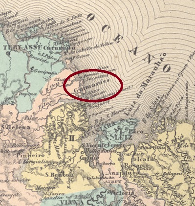
The Freguesia de S. José de Guimarães was founded in March 1758 on the north bank of the Guarapiranga estuary, 140 kilometres northwest of the later provincial capital São Luís do Maranhão. In April 1835, it was elevated to a vila and in February 1920 to a town.
Three dates close to each other have been found for the creation of the local post office. Nova Monteiro, in Administrações e Agencias Postaes do Brasil Imperio (Brasil Filatelico/RJ, 1934-5; reprint SPP 1994-1999), mentions March 1846, which is confirmed by the regional press:
Publicador Maranhense, 30/05/1846
R. Koester (Carimbologia XXI) and the postal report (Relatorio Postal) of 1886 give May 1846 as the date of creation of the agency, and finally the Brazilian statistics authority IBGE writes the year 1847 for it.
Two postmarks have so far been found for the imperial period. R. Koester (op. cit.) shows the postmark GMA-0130a, with the typical form of the province of Maranhão:
GMA-0130a (RK) 1850ff
The philatelist Jorge Luiz Pedreira has provided an image of GMA-0130b:
GMA-0130b (JLP) 1881Villiers de l’Ile Adam: Carta (…) da Provincia do Maranhão, 1850
Die Freguesia de S. José de Guimarães wurde im März 1758 gegründet und lag am Nordufer der Mündung des Guarapiranga, 140 km nordwestlich der späteren Provinzhauptstadt São Luís do Maranhão. Im April 1835 wurde es zur Vila und im Februar 1920 zur Stadt erhoben.
Für die Gründung des örtlichen Postamtes wurden drei Daten gefunden, die nahe beieinander liegen. Nova Monteiro nennt in Administrações e Agencias Postaes do Brasil Imperio (Brasil Filatelico/RJ, 1934-5; Reprint SPP 1994-1999) den März 1846, was durch die regionale Presse bestätigt wird:
Publicador Maranhense, 30.05.1846
R. Koester (Carimbologia XXI) und der Postbericht (Relatorio Postal) von 1886 nennen den Mai 1846 als Gründungsdatum der Agentur, und schließlich gibt die brasilianische Statistikbehörde IBGE das Jahr 1847 dafür an.
Für die Kaiserzeit wurden bisher zwei Poststempel gefunden. R. Koester (a.a.O.) zeigt GMA-0130a, mit der für die Provinz Maranhão typischen Stempelform:
GMA-0130a (RK) 1850ff
Und der Philatelist Jorge Luiz Pedreira lieferte eine Abbildung von GMA-0130b:
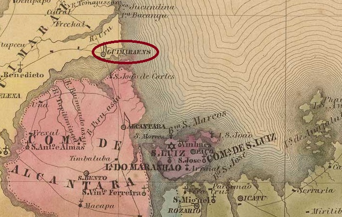
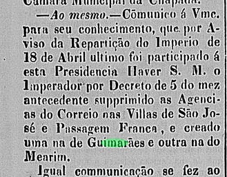
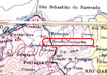
Here we have a post office that was in operation for no more than 1 ½ years, in a railway station that has not existed for almost a century. Guimarães station was opened in July 1880 by the railway company E.F. União Valenciana (Jacutinga branch) in the Vila de Valença area, 180 km north-west of the capital Rio de Janeiro. The railway line became the property of E.F. Central do Brasil in 1910, but Guimarães station was closed by 1928. Today, neither the tracks nor the station building can be seen (estacoesferroviarias.com.br).
According to P. Novaes, the post office was built after the opening of the railway station (agenciaspostais.com.br). However, it closed in December 1881, as reported by the Rio press:
Gazeta de Notícias, 18/12/1881
No imperial postmark from Guimarães station has ever been seen before. It is certainly one of the great rarities of Brazilian philately.
agenciaspostais.com.br
Hier haben wir ein Postamt, das höchstens 1 ½ Jahre in Betrieb war, in einem Bahnhof, der seit fast einem Jahrhundert nicht mehr existiert. Der Bahnhof Guimarães wurde im Juli 1880 von der Eisenbahngesellschaft E.F. União Valenciana (Zweig Jacutinga) eröffnet und lag in der Gegend von Vila de Valença, 180 km nordwestlich der Hauptstadt Rio de Janeiro. Die Bahnlinie ging 1910 in den Besitz der E.F. Central do Brasil über, der Bahnhof Guimarães wurde jedoch bereits 1928 geschlossen. Heute sind weder Gleise noch Bahnhofsgebäude zu sehen (estacoesferroviarias.com.br).
Nach der Eröffnung des Bahnhofs soll laut P. Novaes auch das Postamt entstanden sein (agenciaspostais.com.br). Dieses schloss jedoch im Dezember 1881, wie die Presse von Rio berichtete:
Gazeta de Notícias, 18.12.1881
Bisher wurde noch kein kaiserlicher Poststempel vom Bahnhof Guimarães gesehen. Er gehört sicherlich zu den großen Raritäten der brasilianischen Philatelie.
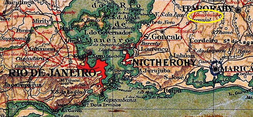
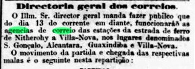
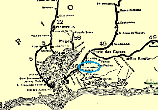
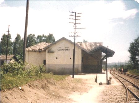
Guaxindiba station was opened around 1873 by the railway company E.F. de Cantagallo and was in the Município de Niterói, 40 km north-east of the capital Rio de Janeiro. In September 1890, the area around the railway station was incorporated into the new Município de S. Gonçalo. The railway line itself was transferred to E.F. Leopoldina in 1911 and belonged to Rede Ferroviária Federal S.A. (estacoesferroviarias.com.br) from 1975 until its closure in 1996. Today, the tracks have disappeared and the station building has been demolished.
In 1979 (Photo: Juarez Spaletta, on estacoesferroviarias.com.br)
As reported in the Rio press, the station post office opened in April 1874:
Jornal do Commercio, 12/04/1874
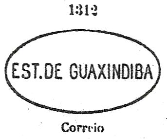
Paulo Novaes writes on agenciaspostais.com.br that the office was closed in October 1910. The imperial postmark is GRJ-1770a, which was given the number 1312 by Paulo Ayres (Catálogo de Carimbos Brasil-Império, S. Paulo, 1937, 1942):
GRJ-1770a (P.A. 1312) 1874-1877ffEstrada de Ferro Leopoldina, 1898
Der Bahnhof Guaxindiba wurde um 1873 von der Eisenbahngesellschaft E.F. de Cantagallo eröffnet und lag im Município de Niterói, 40 km nordöstlich der Hauptstadt Rio de Janeiro. Im September 1890 wurde das Gebiet um den Bahnhof in das neue Município de S. Gonçalo eingegliedert. Die Bahnlinie ihrerseits ging 1911 an die E.F. Leopoldina über und gehörte von 1975 bis zu ihrer Stilllegung 1996 der Rede Ferroviária Federal S.A. (estacoesferroviarias.com.br). Heute sind die Gleise verschwunden, das Bahnhofsgebäude wurde abgerissen.
Im Jahr 1979 (Foto: Juarez Spaletta, auf estacoesferroviarias.com.br)
Wie die Presse in Rio berichtete, nahm das Bahnhofspostamt im April 1874 seinen Betrieb auf:
Jornal do Commercio, 12.04.1874
Paulo Novaes schreibt auf agenciaspostais.com.br, dass das Amt im Oktober 1910 geschlossen wurde. Der kaiserliche Poststempel ist GRJ-1770a, der von Paulo Ayres (Catálogo de Carimbos Brasil-Império, S. Paulo, 1937, 1942) die Nummer 1312 erhielt:
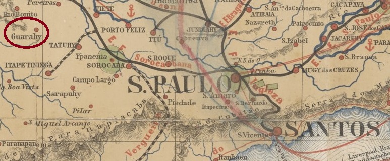
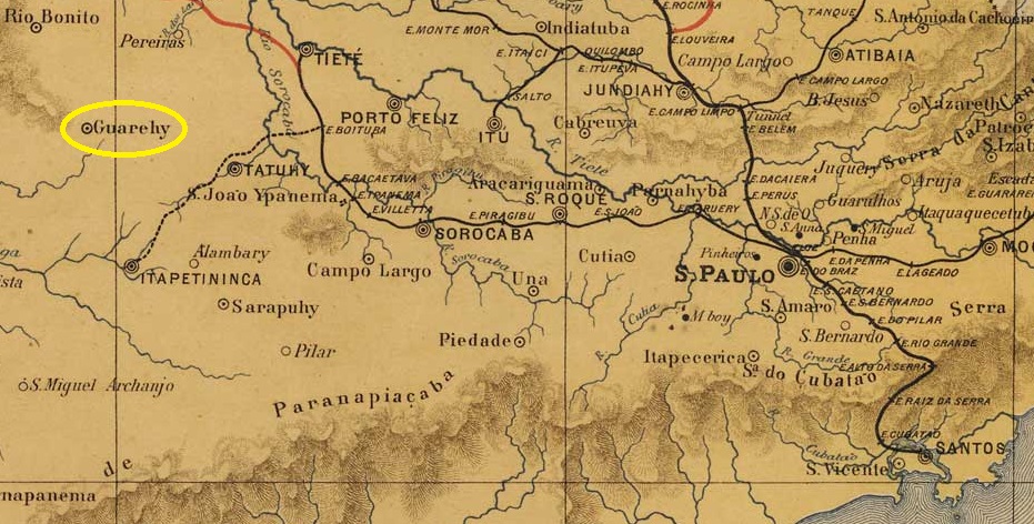
The Freguesia de S. João Baptista de Guarehy, founded in March 1871, belonged to the Vila de Itapetininga and was located on the south bank of the Guareí, 180 kilometres west of the provincial capital of São Paulo. In March 1880, it was elevated to a Vila, but lost this status in July 1934 when it was downgraded to a district of the Município de Tatuí. Since July 1934, Guareí (as it is spelt today) has once again been an independent município.
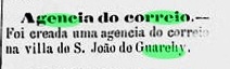
As the regional press reported, there was created a post office in March 1880:
A Constituinte, 28/03/1880
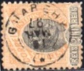
The imperial postmark is the French type GSP-0575a (illustration by Mário Celso Orsi Jr.):
GSP-0575a (MO) 1889-1919J. M. Ribeiro Lisboa: Provincia de São Paulo, 1884
Die im März 1871 gegründete Freguesia de S. João Baptista de Guarehy gehörte zur Vila de Itapetininga und lag am Südufer des Guareí, 180 km westlich der Provinzhauptstadt São Paulo. Im März 1880 wurde es zur Vila erhoben, verlor diesen Status aber im Juli 1934, als es zum Distrikt des Município de Tatuí herabgestuft wurde. Seit Juli 1934 ist Guareí (wie es heute geschrieben wird) wieder ein eigenständiges Município.
Wie die regionale Presse berichtete, gab es dort seit März 1880 ein Postamt:
A Constituinte, 28.03.1880
Der kaiserliche Poststempel ist der französische Typ GSP-0575a (Abb. Mário Celso Orsi Jr.):
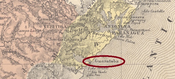
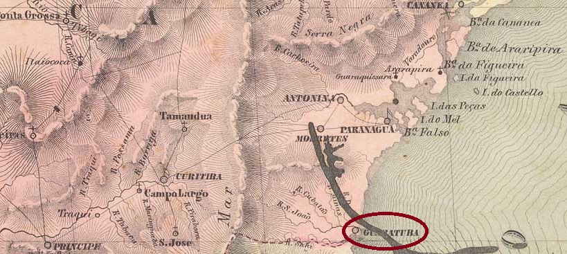
From 1656, Guaratuba was a Freguesia da Vila de Paranaguá, then part of the Capitania de S. Paulo, on the southern shore of the mouth of Guaratuba Bay into the Atlantic Ocean, 130 kilometres south-east of the later provincial capital of Curitiba. In April 1771, the town became Vila de S. Luiz de Guaratuba da Marinha, but lost this status in December 1938 when it was downgraded to a distrito in the Município de Paranaguá. Guaratuba has been an independent município again since November 1951.
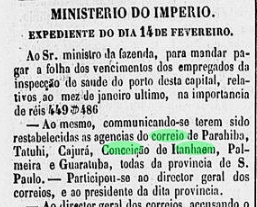
Nova Monteiro writes in Administrações e Agencias Postaes do Brasil Imperio (Brasil Filatelico/RJ, 1934-5; reprint SPP 1994-1999) that there had been a post office there since February 1849. This is confirmed by the Rio press:
Correio Mercantil/RJ, 28/02/1849
However, this press release indicates that it was a reopening (‘restabelecidas as agencias’). Further research revealed that the Guaratuba post office was closed in May 1847:
Relatorio do Ministerio do Imperio, 31/05/1847
And the first opening? This took place in January 1836, as reported by the São Paulo press:
O Paulista Official, 29/01/1836
But there was already postal traffic through Guaratuba in February 1835; the locality was probably an important connection point on the sea mail route between São Paulo and the south of the empire:
O Paulista Official, 17.06.35
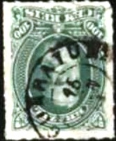
The oldest postmark to date is GPR-0105a, illustrated here by Henrique B. Ferreira (Catálogo ilustrado dos carimbos sobre os olhos-de-boi, 4a. ed, Porto Alegre, 2017)
GPR-0105a (HBF)1843ff-1876ff
The following is the double circle GPR-0105b (image from the internet):
GPR-0105b (EB) 1877-1886Villiers de l’Ile Adam: Carta (…) da Provincia de São Paulo, 1847
Seit 1656 war Guaratuba eine Freguesia da Vila de Paranaguá, damals zur Capitania de S. Paulo gehörend, am Südufer der Mündung der Guaratuba-Bucht in den Atlantik, 130 km südöstlich der späteren Provinzhauptstadt Curitiba. Im April 1771 wurde der Ort Vila de S. Luiz de Guaratuba da Marinha, verlor diesen Status aber im Dezember 1938, als er zu einem Distrito im Município de Paranaguá herabgestuft wurde. Seit November 1951 ist Guaratuba wieder ein unabhängiges Município.
Nova Monteiro schreibt in Administrações e Agencias Postaes do Brasil Imperio (Brasil Filatelico/RJ, 1934-5; Reprint SPP 1994-1999), dass es dort seit Februar 1849 ein Postamt gab. Dies wird von der Rio-Presse bestätigt:
Correio Mercantil/RJ, 28.02.1849
Aus dieser Pressemeldung geht jedoch hervor, dass es sich um eine Wiedereröffnung handelte („restabelecidas as agencias“). Weitere Nachforschungen ergaben, dass das Postamt Guaratuba im Mai 1847 geschlossen wurde:
Relatorio do Ministerio do Imperio, 31.05.1847
Und die erste Eröffnung? Diese fand im Januar 1836 statt, wie die Presse von São Paulo berichtete:
O Paulista Official, 29.01.1836
Aber schon im Februar 1835 gab es Postverkehr durch Guaratuba, der Ort war wohl ein wichtiger Verbindungspunkt auf der Seepostroute zwischen São Paulo und dem Süden des Reiches:
O Paulista Official, 17.06.35
Der bisher älteste Poststempel ist GPR-0105a, hier abgebildet von Henrique B. Ferreira (Catálogo ilustrado dos carimbos sobre os olhos-de-boi, 4a. ed, Porto Alegre, 2017)
GPR-0105a (HBF)1843ff-1876ff
Es folgte der Doppelkreis GPR-0105b (Abbildung aus dem Internet):
Villiers de l’Ile Adam: Carta (…) da Provincia de São Paulo, 1847
Other names: Guaratinguitá
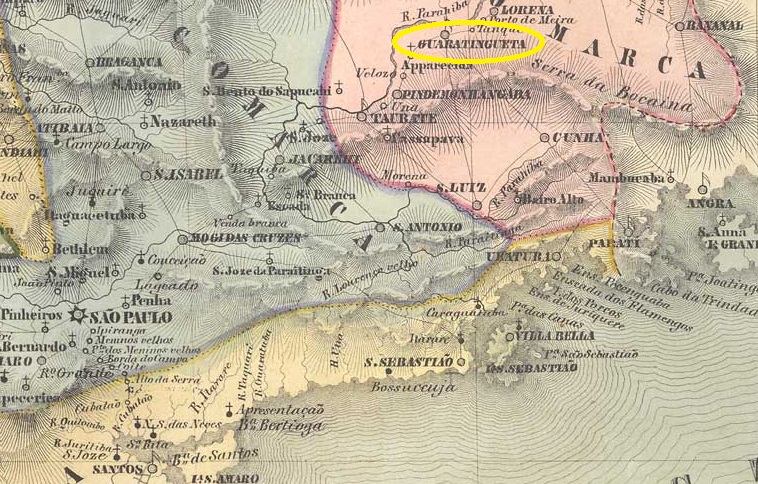
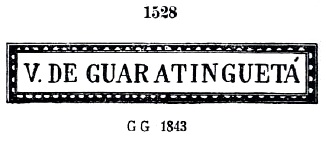
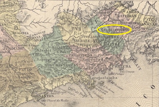
The Freguesia de Sto. Antonio de Guaratinguetá was founded in June 1630, belonged to the Vila de Taubaté and was located on the south bank of the Paraíba do Sul, 180 kilometres north-east of the later provincial capital of São Paulo. It was elevated to Vila status in February 1651 and to city status in January 1844.
According to the list of imperial post offices (Tabella das Agencias do Correio do Imperio, Rio de Janeiro, 1885), there had been a post office there since 1847, but as cancelled letters from Guaratinguetá exist from 1837, the first year mentioned is probably the start of operations under imperial administration. Before that, the post office in the Paraíba Valley is said to have been operated as a kind of joint venture between the provincial government of São Paulo and a private initiative.
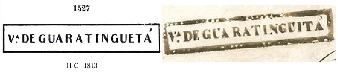
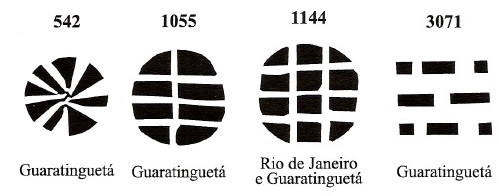
The oldest postmark is GSP-0570a with the number 1527 by Paulo Ayres (Catálogo de Carimbos Brasil-Império, S. Paulo, 1937, 1942). However, the illustration by Ayres raises some questions, as the example opposite shows (fig. Mário Celso Orsi Jr):
GSP-0570a (P.A. 1527 – recte MO) 1837-1843
His successor is very similar to him. GSP-0570b was also pictured by P. Ayres (now with no. 1528) and also appears in red.
GSP-0570b (P.A. 1528) 1843-1852
Around this time, handwritten cancellations with the inscription Goaratinguitá can also be found, as the following illustration shows (Filatélica Brasília):
1843ff (Fil. Brasilia)
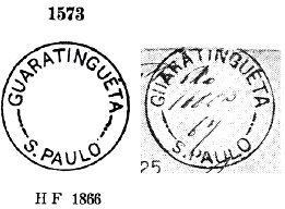
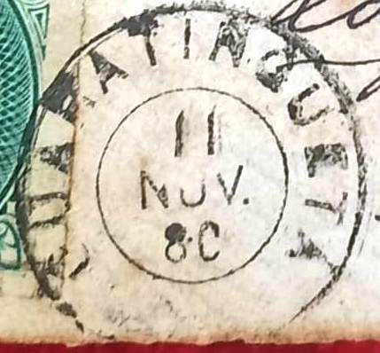
This was followed by the rare GSP-0570c, also illustrated by Ayres (no. 1573), here with an example by R. Koester (op. cit.):
GSP-0570c (P.A. 1573 – RK) 1866ff-1867
This was followed by the French type GSP-0570d (illustrated by Mário Celso Orsi Jr.):
GSP-0570d (MO) 1869-1880
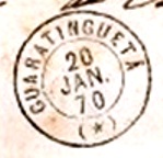
The double circle GSP-0570e (ill. José L. Fevereiro) was then also used:
GSP-0570e (JLF) 1880-1893
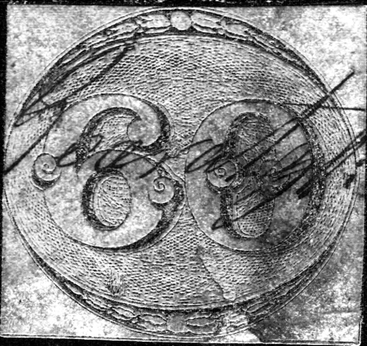
James Dingler and Klerman W. Lopes have presented four mute cancellations from Guaratinguetá in Mute Cancellations of the Brazil Empire / Carimbos Mudos do Brasil Império (Brazil Philatelic Association, Rio de Janeiro, 2000):
Another silent cancellation was shown by José L. Fevereiro:
1880 (JLF)Atlas do Imperio do Brasil, 1868
Andere Namen: Guaratinguitá
Die Freguesia de Sto. Antonio de Guaratinguetá wurde im Juni 1630 gegründet, gehörte zur Vila de Taubaté und lag am Südufer des Paraíba do Sul, 180 km nordöstlich der späteren Provinzhauptstadt São Paulo. Die Erhebung zur Vila erfolgte im Februar 1651, die zur Stadt im Januar 1844.
Wie aus dem Verzeichnis der kaiserlichen Postämter (Tabella das Agencias do Correio do Imperio, Rio de Janeiro, 1885) hervorgeht, gab es dort seit 1847 ein Postamt, da aber gestempelte Briefe aus Guaratinguetá bereits ab 1837 existieren, wird das erste genannte Jahr wohl der Betriebsbeginn unter kaiserlicher Verwaltung sein. Davor soll die Post im Paraíba-Tal in einer Art Joint Venture zwischen der Provinzregierung von São Paulo und privater Initiative betrieben worden sein.
Der älteste Poststempel ist GSP-0570a mit der Nummer 1527 von Paulo Ayres (Catálogo de Carimbos Brasil-Império, S. Paulo, 1937, 1942). Die Abbildung von Ayres weist jedoch einige Fehler auf, wie das nebenstehende Beispiel zeigt (Abb. Mário Celso Orsi Jr):
GSP-0570a (P.A. 1527 – recte MO) 1837-1843
Sein Nachfolger ist ihm sehr ähnlich. GSP-0570b wurde ebenfalls von P. Ayres gezeichnet (jetzt mit der Nr. 1528) und erscheint auch in Rot.
GSP-0570b (P.A. 1528) 1843-1852
Um diese Zeit findet man auch handschriftliche Entwertungen mit der Aufschrift Goaratinguitá, wie die folgende Abbildung zeigt (Filatélica Brasília):
1843ff (Fil. Brasilia)
Es folgte die seltene GSP-0570c, ebenfalls von Ayres (Nr. 1573) abgebildet, hier mit einem Beispiel von R. Koester (op. cit.):
GSP-0570c (P.A. 1573 – RK) 1866ff-1867
Es folgte der französische Typ GSP-0570d (Abb. Mário Celso Orsi Jr.):
GSP-0570d (MO) 1869-1880
Danach wurde auch der Doppelkreis GSP-0570e (Abb. José L. Fevereiro) verwendet:
GSP-0570e (JLF) 1880-1893
James Dingler und Klerman W. Lopes haben in Mute Cancellations of the Brazil Empire / Carimbos Mudos do Brasil Império (Brazil Philatelic Association, Rio de Janeiro, 2000) vier stumme Abstempelungen aus Guaratinguetá vorgestellt:
Villiers de l’Ile Adam: Carta (…) da Provincia do Rio de Janeiro, 1850
Other names: Matriz de Guaratiba, Ponto da Matriz
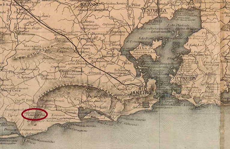
The Freguesia de S. Salvador do Mundo da Guaratiba, located 60 kilometres west of the capital Rio de Janeiro on an important trade route to São Paulo, has existed since January 1755. Guaratiba has been an administrative region of the Município de Rio de Janeiro since July 1981.
As Nova Monteiro writes in Administrações e Agencias Postaes do Brasil Imperio (Brasil Filatelico/RJ, 1934-5; reprint SPP 1994-1999), there had been a post office there since August 1869, which was closed around 1940 according to Paulo Novaes (agenciaspostais.com.br).
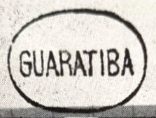
The oldest postmark to date is GMN-0105a (fig. R. Koester, in Carimbologia XXI):
GMN-0105a (RK)
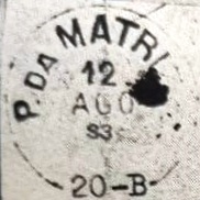
Koester (op. cit.) also shows us the postmark PMN-0120a, with the inscription P. DA MATRIZ for Ponto da Matriz, or stop at the main church. The post office is said to have been located near the main church.
PMN-0120a (RK) 1869-1883Colton & Colton: Provincia do Rio de Janeiro, 1866
Andere Namen: Matriz de Guaratiba, Ponto da Matriz
Seit Januar 1755 bestand die Freguesia de S. Salvador do Mundo da Guaratiba, die 60 km westlich der Hauptstadt Rio de Janeiro an einer wichtigen Handelsstraße nach São Paulo liegt. Seit Juli 1981 ist Guaratiba eine Verwaltungsregion des Município de Rio de Janeiro.
Wie Nova Monteiro in Administrações e Agencias Postaes do Brasil Imperio (Brasil Filatelico/RJ, 1934-5; Reprint SPP 1994-1999) schreibt, gab es dort seit August 1869 ein Postamt, das nach Paulo Novaes (agenciaspostais.com.br) um 1940 geschlossen wurde.
Der bisher älteste Poststempel ist GMN-0105a (Abb. R. Koester, in Carimbologia XXI):
GMN-0105a (RK)
Koester (op. cit.) zeigt uns auch den Stempel PMN-0120a, mit der Inschrift P. DA MATRIZ für Ponto da Matriz, oder Haltestelle an der Hauptkirche. Das Postamt soll sich in der Nähe der Hauptkirche befunden haben.
Estações (…) do Rio de Janeiro, São Paulo e Minas Geraes, 1880
Other names: Parahyba
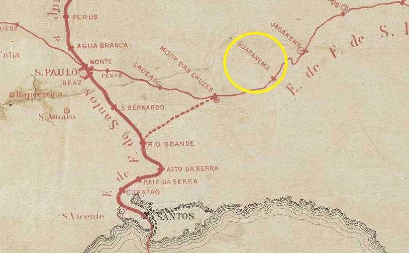
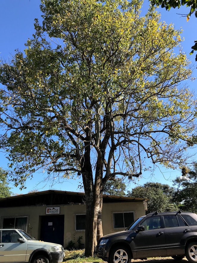
Opened in April 1876 by the E.F. do Norte railway company, the station was originally called Parahyba and was located on the south bank of the river of the same name in the Vila de Mogi das Cruzes region, 80 km east of the provincial capital of São Paulo. A year later, the station was renamed Guararema, the name comes from the Tupi and means stinking tree. This refers to the garlic tree or Pau d’Alho (Gallesia integrifolia, Spreng.), which is now the town’s landmark:
Gallesia integrifolia (photo Yara Pereira, UENF)
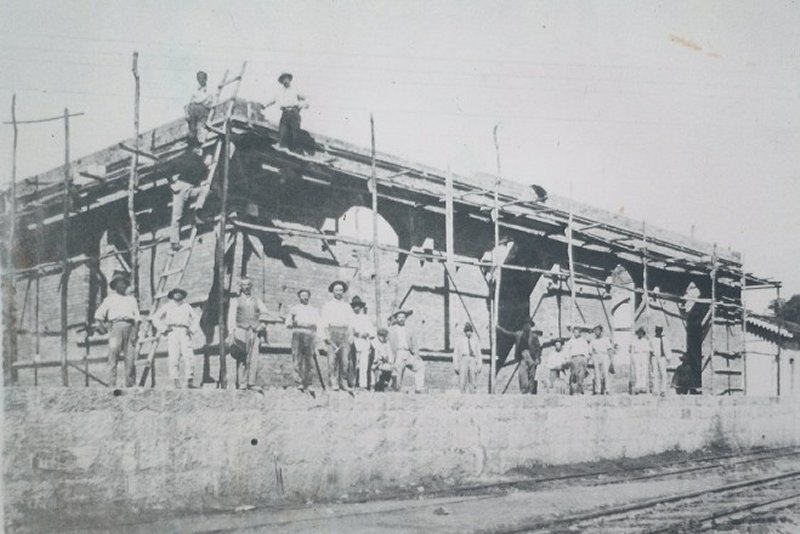
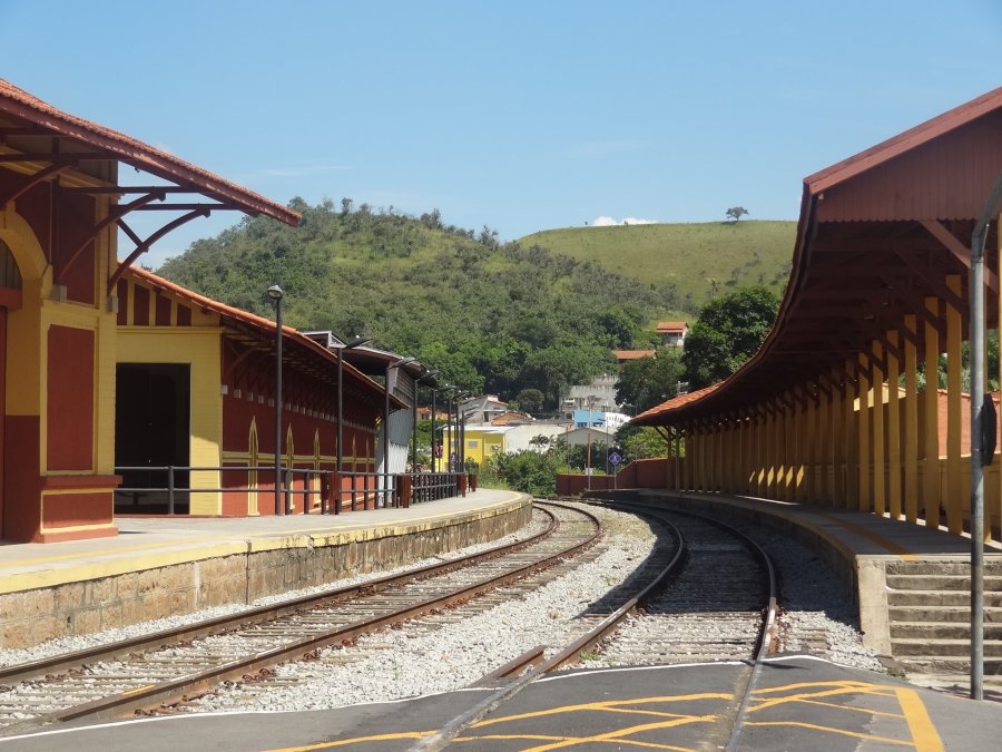
The railway line was taken over by E.F. Central do Brasil in 1889 and belonged to Rede Ferroviária Federal S.A. from 1975 to 1998 (estacoesferroviarias.com.br). Today, the tracks still exist and the station building serves as a local history museum for the municipality of Guararema, which was created in June 1898.
In 1927 (on estacoesferroviarias.com.br)In April 2017 (photo: José Carlos Daltozo, on estacoesferroviarias.com.br)
Three dates of creation have been found for the station post office. The first in September 1877, as reported in the regional press:
Correio Paulistano, 23/10/1877
The Rio press reported on a new post office in Guararema station the following December:
Diario do Rio de Janeiro, 11/12/1877
The third opening date was announced in August 1879 and confirmed by the Imperial Postal Guide (Guia Postal do Imperio, Rio de Janeiro, 1880):
Correio Paulistano, 21/08/1879
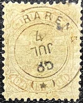
It follows from this that the post office at the railway station was closed at least once in the meantime. The oldest postmark to date is the French type GSP-0565a (Klerman W. Lopes collection):
GSP-0565a (KL) 1883ff-1886
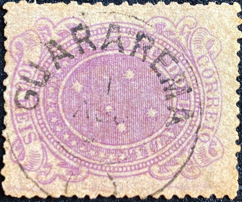
It was followed at the beginning of the Republic by GSP-0565b (fig. Felipe Piccinini):
GSP-0565b (FP) 1890ffEstrada de Ferro Central do Brasil, 1890
Andere Namen: Parahyba
Der im April 1876 von der Eisenbahngesellschaft E.F. do Norte eröffnete Bahnhof hieß ursprünglich Parahyba und lag am Südufer des gleichnamigen Flusses in der Region Vila de Mogi das Cruzes, 80 km östlich der Provinzhauptstadt São Paulo. Ein Jahr später wurde die Station in Guararema umbenannt, der Name stammt aus dem Tupi und bedeutet stinkender Baum. Gemeint ist der Knoblauchbaum oder Pau d’Alho (Gallesia integrifolia, Spreng.), der heute das Wahrzeichen des Ortes ist:
Gallesia integrifolia (Foto Yara Pereira, UENF)
Die Bahnlinie wurde 1889 von der E.F. Central do Brasil übernommen und gehörte von 1975 bis 1998 der Rede Ferroviária Federal S.A. (estacoesferroviarias.com.br). Heute sind die Gleise noch vorhanden, das Bahnhofsgebäude dient als Heimatmuseum der seit Juni 1898 bestehenden Gemeinde Guararema.
Im Jahr 1927 (auf estacoesferroviarias.com.br)Im April 2017 (Foto José Carlos Daltozo, auf estacoesferroviarias.com.br)
Für das Bahnhofspostamt wurden drei Entstehungsdaten gefunden. Das erste im September 1877, wie die regionale Presse berichtete:
Correio Paulistano, 23.10.1877
Die Presse von Rio berichtete im darauffolgenden Dezember über ein neues Postamt in Guararema:
Diario do Rio de Janeiro, 11.12.1877
Der dritte Eröffnungstermin wurde im August 1879 bekannt gegeben und vom Kaiserlichen Postführer bestätigt (Guia Postal do Imperio, Rio de Janeiro, 1880):
Correio Paulistano, 21.08.1879
Daraus folgt, dass das Postamt am Bahnhof zwischenzeitlich mindestens einmal geschlossen war. Der bisher älteste Poststempel ist der französische Typ GSP-0565a (Samml. Klerman W. Lopes):
GSP-0565a (KL) 1883ff-1886
Ihm folgte zu Beginn der Republik GSP-0565b (Abb. Felipe Piccinini):