Categories
Carimbologia E-G

Forquilha (train station/Bahnhof), Rio de Janeiro (FRJ-0555)

Estado de Minas Geraes, 1910

Other names: José Leite, Leite de Souza (1936)

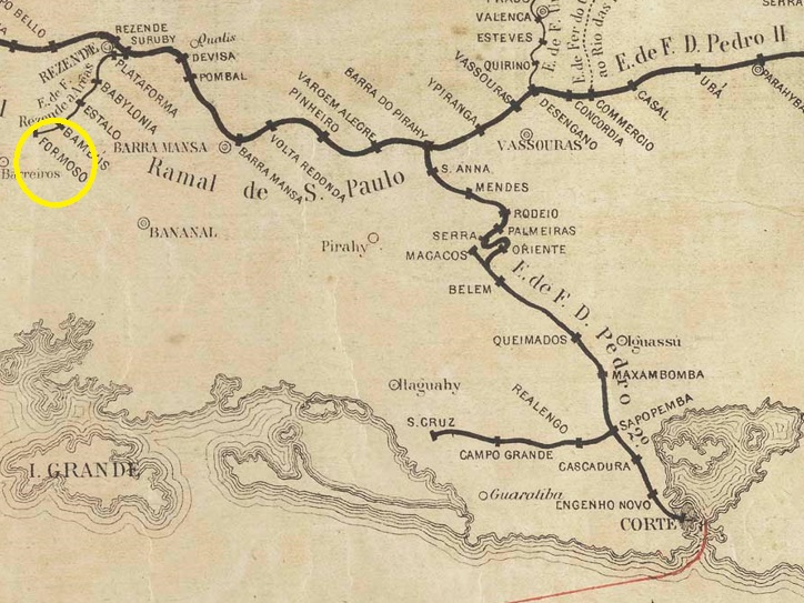
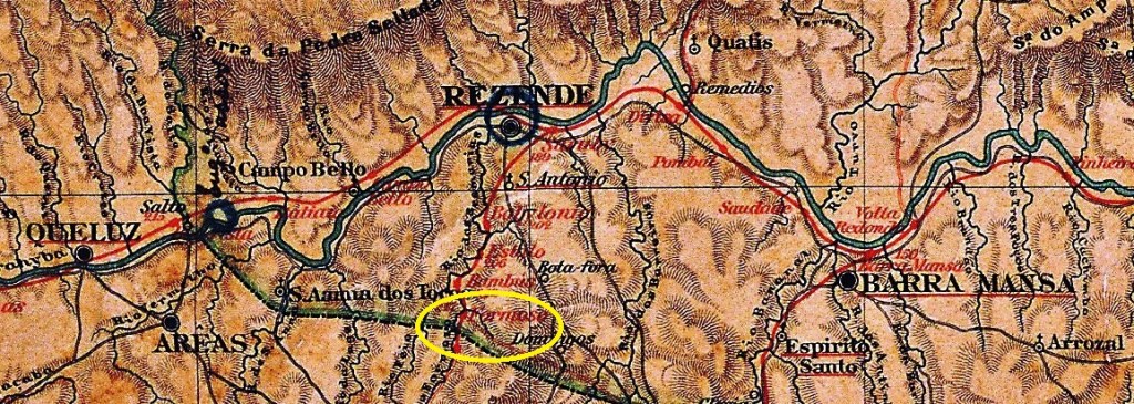
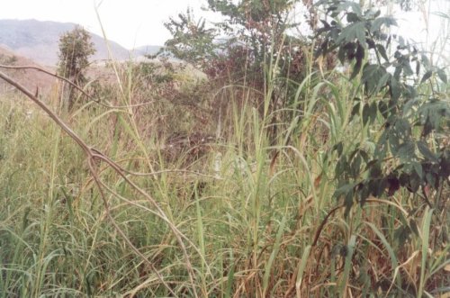
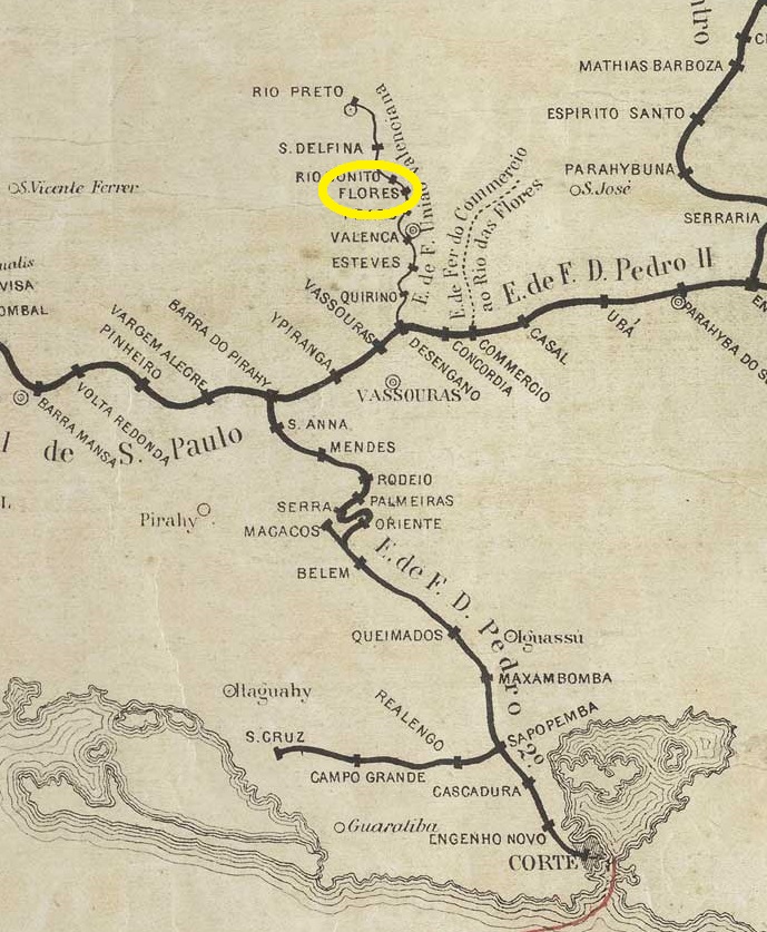
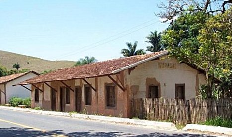
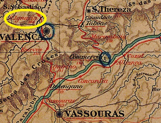
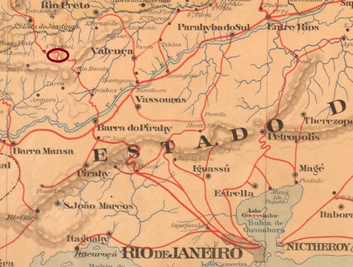
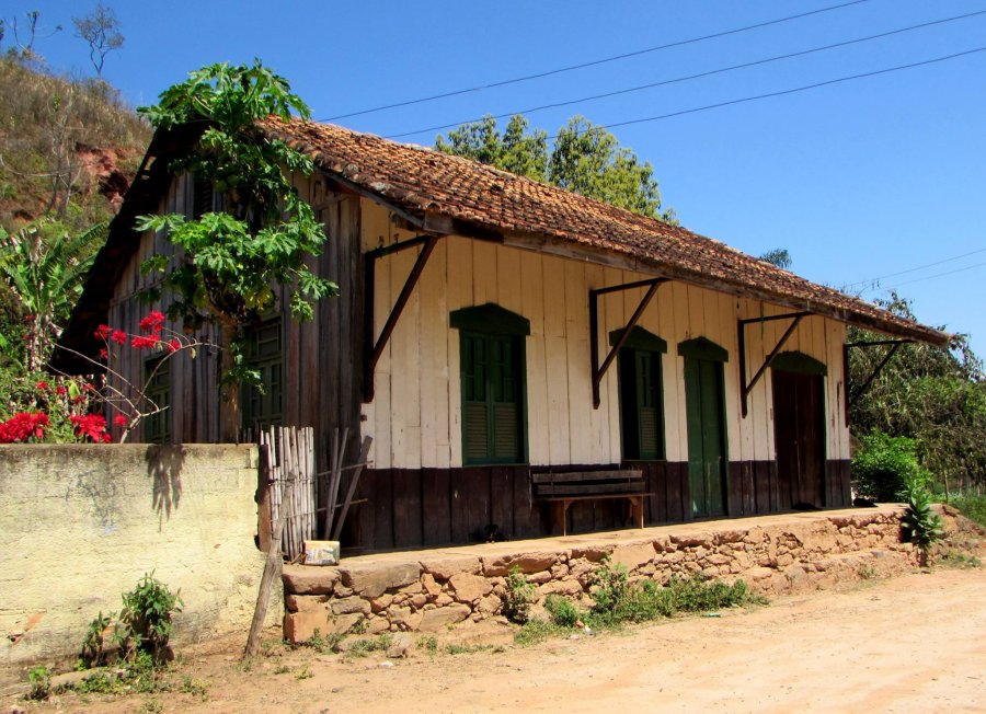
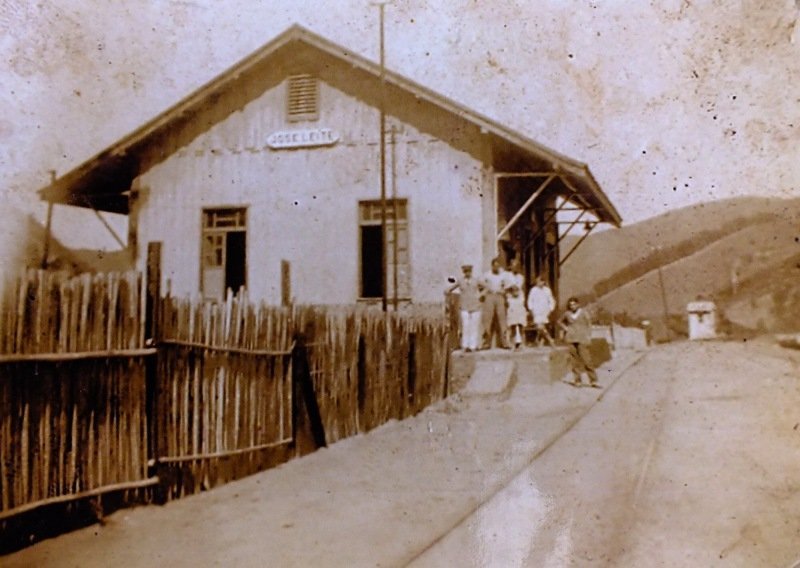
Forquilha (Fork) station was opened in January 1886 by the railway company E.F. Sta. Izabel do Rio Preto (Barra Line) in the Município Valença, 180 km north-west of Rio de Janeiro. The station then changed its name twice: in 1889 to José Leite and in 1936 to Leite de Souza. In 1893 the line became the property of V.F. Sapucaí, in 1910 of Rede Sul-Mineira and from 1931 until its closure in 1961 of Rede Mineira de Viação. Today, the tracks have disappeared and the station building serves as a residential building.

Around 1930 (Photo: NN, on estacoesferroviarias.com.br)
In 2016 (Photo: Alexandre Ferreira, on estacoesferroviarias.com.br)

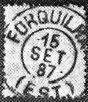
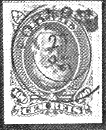
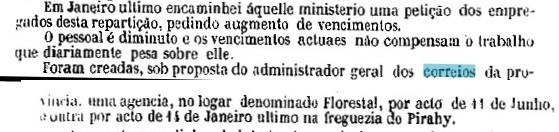
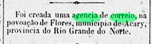
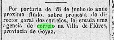
According to the Rio press, there was a post office at the railway station from January 1887:

Jornal do Commercio, 27/01/1887

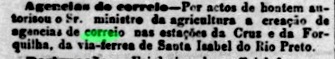
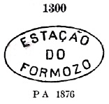
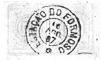
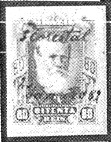
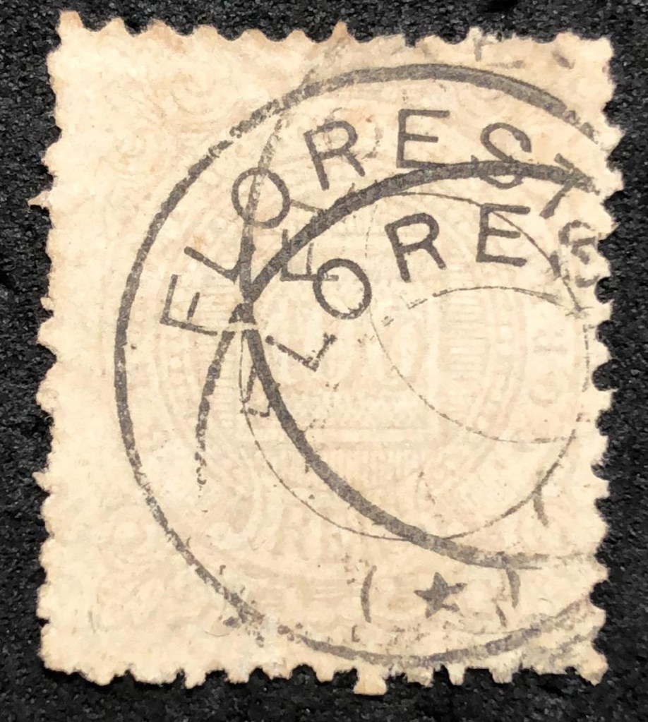
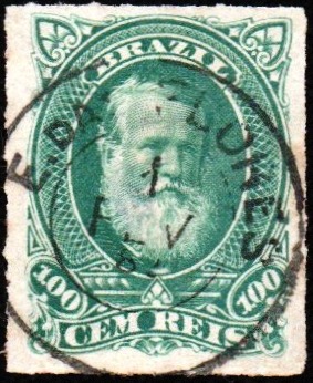
Paulo Novaes writes on agenciaspostais.com.br that the post office was also renamed around 1888. Seen in this light, the first postmark FRJ-0555a (fig. R. Koester, on Carimbologia XIX) would be quite rare:

FRJ-0555a (RK) 1887
Almanak Laemmert, 1892

Andere Namen: José Leite, Leite de Souza (1936)

Der Bahnhof Forquilha (Gabelung) wurde im Januar 1886 von der Eisenbahngesellschaft E.F. Sta. Izabel do Rio Preto (Linie Barra) eröffnet und lag im Município Valença, 180 km nordwestlich von Rio de Janeiro. Danach änderte der Bahnhof zweimal seinen Namen: 1889 in José Leite und 1936 in Leite de Souza. 1893 ging die Strecke in den Besitz der V.F. Sapucaí über, 1910 in den der Rede Sul-Mineira und von 1931 bis zu ihrer Stilllegung 1961 in den der Rede Mineira de Viação. Heute sind die Gleise verschwunden, das Bahnhofsgebäude dient als Wohnhaus.

Um 1930 (Foto: NN, auf estacoesferroviarias.com.br)
2016 (Foto: Alexandre Ferreira, auf estacoesferroviarias.com.br)

Wie aus der Presse in Rio hervorgeht, gab es ab Januar 1887 ein Postamt am Bahnhof:

Jornal do Commercio, 27.01.1887

Paulo Novaes schreibt auf agenciaspostais.com.br, dass bereits um 1888 auch das Postamt umbenannt wurde. So gesehen wird der erste Poststempel FRJ-0555a (Abb. R. Koester, auf Carimbologia XIX) ziemlich selten sein:

FRJ-0555a (RK) 1887
Categories
Carimbologia E-G

Formoso (train station/Bahnhof), São Paulo (FSP-0540)

Estações (…) do Rio de Janeiro, São Paulo e Minas Geraes, 1880

Formoso station (also spelt Formozo) was opened in January 1878 by the railway company E.F. de Resende a Areias (Main Line) and was located on the east bank of the Formoso in the Município de S. José do Barreiro, 290 km east of the provincial capital of São Paulo. The line was in operation until 1928. Today, there are no longer any tracks or station buildings, only ruins can still be recognised.

In 2001 (Photo: Marco Giffoni on estacoesferroviarias.com.br)

As the station was located just outside the provincial border, its post office was operated by the Rio postal administration until 1900. Two founding dates have been found for the station post office. Paulo Novaes (agenciaspostais.com.br) mentions July 1878, while R. Koester (Carimbologia XIX) gives the same date exactly four years later. The oldest postmark is FSP-0540a, which was given the no. 1300 by P. Ayres (Catálogo de Carimbos Brasil-Império, S. Paulo, 1937, 1942):

FSP-0540a (P.A. 1300) 1878ff

This was followed by the double circle FSP-0540b (fig. R. Koester, op. cit.):

FSP-0540b (RK) 1881

FSP-0540c (fig. R. Koester) also appeared afterwards:

FSP-0540c (RK) 1885-1888
Almanak Laemmert, 1892

Der Bahnhof Formoso (auch Formozo geschrieben) wurde im Januar 1878 von der Eisenbahngesellschaft E.F. de Resende a Areias (Hauptlinie) eröffnet und lag am Ostufer des Formoso im Município de S. José do Barreiro, 290 km östlich der Provinzhauptstadt São Paulo. Die Strecke war bis 1928 in Betrieb. Heute sind weder Gleise noch Bahnhofsgebäude mehr vorhanden, nur Ruinenreste sind noch zu erkennen.

2001 (Foto: Marco Giffoni auf estacoesferroviarias.com.br)

Da der Bahnhof unmittelbar vor der Provinzgrenze lag, wurde sein Postamt bis 1900 von der Postverwaltung Rio betrieben. Für das Bahnhofspostamt wurden zwei Gründungsdaten gefunden. Paulo Novaes (agenciaspostais.com.br) nennt den Juli 1878, während R. Koester (Carimbologia XIX) das gleiche Datum erst vier Jahre später angibt. Der älteste Poststempel ist FSP-0540a der von P. Ayres (Catálogo de Carimbos Brasil-Império, S. Paulo, 1937, 1942) die Nr. 1300 erhielt:

FSP-0540a (P.A. 1300) 1878ff

Es folgte der Doppelkreis FSP-0540b (Abb. R. Koester, op. cit.):

FSP-0540b (RK) 1881

Danach erschien auch FSP-0540c (Abb. R. Koester):

FSP-0540c (RK) 1885-1888
Categories
Carimbologia E-G

Formosa, Goiás (FGO-0075)

Teixeira Neto: Capitania de Goiás, 1809

Other names: Couros, Villa Formosa da Imperatriz

See also Couros (CGO-0052)

Couros (pieces of leather) was from around 1750 an arraial of the Freguesia de Sta. Luzia on the west bank of the Rio Preto, 390 km east of the later provincial capital Goyaz (today: Goiás Velho). The village was elevated to a freguesia in August 1838 and five years later to Villa Formosa da Imperatriz. It has been the town of Formosa since July 1877.

As Nova Monteiro writes in Administrações e Agencias Postaes do Brasil Imperio (Brasil Filatelico/RJ, 1934-5; Reprint SPP 1994-1999), there had been a post office there since March 1829. A second post office is said to have been opened in February 1835, as R. Koester writes in Carimbologia XIX. This post office was still in operation in 1839, as can be seen from a report by the imperial ministry:

Relatorio do Ministerio do Imperio, 1839

It is not known when the Couros postal agency was closed. However, since the name change to Formosa took place in August 1843, postmarks from Couros from this date onwards are rather unlikely. R. Koester mentions two post office openings for Villa Formosa in Carimbologia XIX, in 1863 and 1869. In between, in March 1866, a postal line was applied for between Formosa and Carinhanha (Bahia province), which would indicate the existence of postal activities in both places:

Correio Official de Goyaz, 14/03/1866

The opening of the post office in 1869 is confirmed by the regional press:

Correio Official de Goyaz, 23/10/1869

Koester (op. cit.) mentions the postmark FGO-0075b (without illustration) in blue in 1884.

Villiers de l’Ile Adam: Carta (…) da Provincia de Goyaz, 1849

Andere Namen: Couros, Villa Formosa da Imperatriz

Siehe auch Couros (CGO-0052)

Couros (Lederstücke) war ab ca. 1750 ein Arraial der Freguesia de Sta. Luzia am Westufer des Rio Preto, 390 km östlich der späteren Provinzhauptstadt Goyaz (heute: Goiás Velho). Der Ort wurde im August 1838 zur Freguesia und fünf Jahre später zur Villa Formosa da Imperatriz erhoben. Seit Juli 1877 ist es die Stadt Formosa.

Wie Nova Monteiro in Administrações e Agencias Postaes do Brasil Imperio (Brasil Filatelico/RJ, 1934-5; Reprint SPP 1994-1999) schreibt, gab es dort seit März 1829 ein Postamt. Eine zweite Postamteröffnung soll im Februar 1835 stattgefunden haben, wie R. Koester in Carimbologia XIX schreibt. 1839 war dieses Postamt noch in Betrieb, wie aus einem Bericht des kaiserlichen Ministeriums hervorgeht:

Relatorio do Ministerio do Imperio, 1839

Es ist nicht bekannt, wann die Postagentur von Couros geschlossen wurde. Da aber die Namensänderung in Formosa im August 1843 erfolgte, sind Poststempel von Couros ab diesem Datum eher unwahrscheinlich. R. Koester erwähnt zwei Postamteröffnungen für die Villa Formosa in Carimbologia XIX, in den Jahren 1863 und 1869. Dazwischen, im März 1866, wurde eine Postlinie zwischen Formosa und Carinhanha (Provinz Bahia) beantragt, was auf die Existenz eines aktiven Postamtes in beiden Orten hindeuten würde:

Correio Official de Goyaz, 14.03.1866

Die Eröffnung des Postamts 1869 wird durch die regionale Presse bestätigt:

Correio Official de Goyaz, 23.10.1869

Koester (op. cit.) erwähnt den Kreisstempel FGO-0075b (ohne Abbildung) mit der Jahreszahl 1884 in blau.

Categories
Carimbologia E-G

Formiga, Minas Gerais (FMG-1180)

Provincia de Minas Geraes, 1873

See also Villa da Formiga (VMG-3644)

The parish of S. Vicente Ferrer da Formiga was established in July 1832 in the município of Tamanduá, 290 km west of the provincial capital Ouro Preto. There was no danger to the ant (Formiga) from the anteater (Tamanduá) because the Serra Geral lies between both. In March 1839, the village rose to become Villa Nova da Formiga, and has been a town since June 1858.

Both Paula Sobrinho (História Postal de Minas Gerais, Belo Horizonte, 1997) and Reinhold Koester (Carimbologia XIX) agree that the local post office was created in March 1840. Two early postmarks have already been recorded. VMG-3644a also exists in sepia, was used from 1840 to at least 1843 and is known through the RHM catalogue:

VMG-3644a (RHM P-MG-28) 1840-1843ff

Its successor VMG-3645a was in use from about 1843 and was already known by Paulo Ayres (Catálogo de Carimbos Brasil-Império, S. Paulo, 1937, 1942) with no. 1600:

VMG-3645a (P.A.1600) 1843ff-1846

Later postmarks bear only the place name FORMIGA. The first was FMG-1180a, which was already presented by P. Ayres (Catálogo de Carimbos Brasil-Império, S. Paulo, 1937, 1942) under no. 1299:

FMG-1180a (P.A. 1299) 1850ff-1866ff

This was followed by the French type FMG-1180b (ill. Roberto Assef Jr.), which was used for quite a long time:

FMG-1180b (RA) 1877-1913

Three other mute cancels from Formiga were shown by James Dingler and Klerman W. Lopes in Mute Cancellations of the Brazil Empire/ Carimbos Mudos do Brasil Império (Brazil Philatelic Association, Rio de Janeiro, 2000) under the numbers 1336, 4179 and 4182:

BPA 1336 (P.A. 271, 1882-1883) – 4179 (1877) – 4182
Atlas do Imperio do Brasil, 1868

Siehe auch Villa da Formiga (VMG-3644)

Die Pfarrei S. Vicente Ferrer da Formiga wurde im Juli 1832 im Município Tamanduá errichtet, 290 km westlich der Provinzhauptstadt Ouro Preto. Der Ameisenbär (Tamanduá) stellte keine Gefahr für die Ameise (Formiga) dar, da zwischen beiden die Serra Geral liegt. Im März 1839 wurde der Ort Villa Nova da Formiga und im Juni 1858 zur Stadt erhoben.

Paula Sobrinho (História Postal de Minas Gerais, Belo Horizonte, 1997) und Reinhold Koester (Carimbologia XIX) sind sich einig, dass das örtliche Postamt im März 1840 gegründet wurde. Zwei frühe Poststempel sind bereits bekannt. VMG-3644a existiert auch in Sepia, wurde von 1840 bis mindestens 1843 verwendet und ist aus dem RHM-Katalog bekannt:

VMG-3644a (RHM P-MG-28) 1840-1843ff

Der Nachfolger VMG-3645a wurde ab ca. 1843 verwendet und ist durch Paulo Ayres (Catálogo de Carimbos Brasil-Império, S. Paulo, 1937, 1942) mit der Nr. 1600 bekannt:

VMG-3645a (P.A.1600) 1843ff-1846

Spätere Poststempel tragen nur noch die Ortsbezeichnung FORMIGA. Der erste war FMG-1180a, die bereits von P. Ayres (Catálogo de Carimbos Brasil-Império, S. Paulo, 1937, 1942) unter der Nr. 1299 vorgestellt wurde:

FMG-1180a (P.A. 1299) 1850ff-1866ff

Danach erschien der französische Typ FMG-1180b (Abb. Roberto Assef Jr.), der recht lange verwendet wurde:

FMG-1180b (RA) 1877-1913

Drei weitere stumme Stempel aus Formiga wurden von James Dingler und Klerman W. Lopes in Mute Cancellations of the Brazil Empire/ Carimbos Mudos do Brasil Império (Brazil Philatelic Association, Rio de Janeiro, 2000) unter den Nummern 1336, 4179 und 4182 gezeigt:

BPA 1336 (P.A. 271, 1882-1883) – 4179 (1877) – 4182
Categories
Carimbologia E-G

Florestal, Paraná (FPR-0090)

Google Maps

Florestal is another place in the Brazilian Empire that has now disappeared from the map. In the 19th century, it was a small settlement on the famous Graciosa Road (Estrada da Graciosa), 30 kilometres east of the provincial capital Vila de Curitiba, and has remained so to this day. Only the administrative jurisdiction changed several times: in November 1883 to Vila de Campina Grande, in October 1938 to the Município de Piraquara, in November 1951 to the Município de Timbu (formerly Campina Grande), in February 1956 to the Município de Campina Grande do Sul (formerly Timbu) and finally in January 1961 to the newly founded Município de Quatro Barras. Florestal is now a rural suburb of the town of Quatro Barras, recognisable by a primary school and a shop that still bear the old place name.

The local post office was established in June 1878, as can be seen from the report of the provincial president from the following March:

Relatorio do Presidente da Provincia, 03/1879

R. Koester shows in Carimbologia XIX a handwritten cancellation from 1882, as apparently the postmark was not delivered on time.

1882 (RK)

Philatelist Mario Celso Orsi Jr. has supplied the oldest illustration of postmark FPR-0090a to date:

FPR-0090a (MO) 1885-1887
Estado do Paraná, 1896

Mit Florestal haben wir einen weiteren Ort im Kaiserreich Brasilien, der heute von der Landkarte verschwunden ist. Es war im 19. Jahrhundert eine kleine Siedlung an der berühmten Graciosa-Straße (Estrada da Graciosa), 30 km östlich der Provinzhauptstadt Vila de Curitiba, und so ist es bis heute geblieben. Nur die administrative Zuständigkeit wechselte mehrmals: im November 1883 zu Vila de Campina Grande, im Oktober 1938 zum Município de Piraquara, im November 1951 zum Município de Timbu (ehemals Campina Grande), im Februar 1956 zum Município de Campina Grande do Sul (ehemals Timbu) und schließlich im Januar 1961 zum neu gegründeten Município de Quatro Barras. Florestal ist heute ein ländlicher Vorort der Stadt Quatro Barras, erkennbar an einer Grundschule und einem Laden, die noch den alten Ortsnamen tragen.

Das örtliche Postamt wurde im Juni 1878 eingerichtet, wie aus dem Bericht des Provinzpräsidenten vom folgenden März hervorgeht:

Relatorio do Presidente da Provincia, 03/1879

R. Koester zeigt in Carimbologia XIX eine handschriftliche Entwertung von 1882 als Indiz dafür, dass der Poststempel nicht rechtzeitig geliefert wurde.

1882 (RK)

Der Philatelist Mario Celso Orsi Jr. stellte die bisher älteste Abbildung des Poststempels FPR-0090a zur Verfügung:

FPR-0090a (MO) 1885-1887
Categories
Carimbologia E-G

Floresta, Pernambuco (FPE-0260)

Carta da Republica dos Estados Unidos do Brazil, 1892

Other names: Fazenda Grande

The history of the village is said to have begun in March 1778, when the settlement of Senhor Bom Jesus dos Aflitos da Fazenda Grande started on the west bank of the Pajeú, 440 kilometres west of the future provincial capital Recife. The Freguesia de Fazenda Grande, which belonged to Vila de Flores, was founded there in September 1802. In June 1849, the Freguesia was transferred to the Vila de Tacaratu and became a Vila itself in April 1864 under the place name Floresta. Floresta has been a town since June 1907.

No fewer than four foundation dates have been found for the local post office. In Carimbologia XIX, R. Koester mentions both March 1829 and 1850, which seems less plausible as Floresta was still called Fazenda Grande at the time. This could be a confusion with Flores from Pernambuco (FPE-0255). The directory of imperial post offices (Tabella das Agencias do Correio do Imperio, Rio de Janeiro, 1885) states that the agency had existed since 1855, and this information was adopted in the postal report (Relatorio Postal) of 1886. Even if the Freguesia was already known as Floresta at this time, it is unlikely that it received its post office before the headquarters of Vila de Tacaratu (TPE-0610, P.O. from 1858).

From this point of view, the fourth date of June 1865 remains the most likely for the foundation of the post office, as Nova Monteiro writes in Administrações e Agencias Postaes do Brasil Imperio (Brasil Filatelico/RJ, 1934-5; reprint SPP 1994-1999) and is confirmed by the press in Rio:

Diario do Rio de Janeiro, 07/06/1865

The oldest postmark here so far is the French type FPE-0260b (coll. Marco Morel):

FPE-0260b (ME) 1885ff-1890ff
Carta Corographica da Provincia de Pernambuco, 1880

Andere Namen: Fazenda Grande

Die Geschichte des Ortes soll im März 1778 begonnen haben, als am Westufer des Pajeú, 440 km westlich der späteren Provinzhauptstadt Recife, die Siedlung Senhor Bom Jesus dos Aflitos da Fazenda Grande entstand. Im September 1802 wurde dort die Freguesia de Fazenda Grande gegründet, die zu Vila de Flores gehörte. Im Juni 1849 ging die Freguesia an die Vila de Tacaratu über und wurde im April 1864 unter dem Ortsnamen Floresta selbst zur Vila. Seit Juni 1907 ist Floresta eine Stadt.

Für das örtliche Postamt wurden nicht weniger als vier Gründungsdaten gefunden. R. Koester nennt in Carimbologia XIX sowohl den März 1829 als auch das Jahr 1850 dafür, was weniger plausibel erscheint, da Floresta damals noch Fazenda Grande hieß. Hier könnte eine Verwechslung mit Flores aus Pernambuco (FPE-0255) vorliegen. Im Verzeichnis der kaiserlichen Postämter (Tabella das Agencias do Correio do Imperio, Rio de Janeiro, 1885) ist zu lesen, dass die Agentur seit 1855 bestand, diese Angabe wurde im Postbericht (Relatorio Postal) von 1886 übernommen. Auch wenn die Freguesia zu dieser Zeit bereits als Floresta bekannt war, ist es unwahrscheinlich, dass sie ihr Postamt vor dem Sitz in Vila de Tacaratu (TPE-0610, Postamt ab 1858) erhalten hätte.

So gesehen bleibt das vierte Datum vom Juni 1865 das wahrscheinlichste für die Gründung des Postamtes, wie Nova Monteiro in Administrações e Agencias Postaes do Brasil Imperio (Brasil Filatelico/RJ, 1934-5; Reprint SPP 1994-1999) schreibt und von der Presse in Rio bestätigt wird:

Diario do Rio de Janeiro, 07.06.1865

Der bisher älteste Poststempel hier ist der französische Typ FPE-0260b (Samml. Marco Morel):

FPE-0260b (ME) 1885ff-1890ff
Categories
Carimbologia E-G

Flores, Rio Grande do Norte (FRN-0070)

Sociedade Geológica e Mineralógica, 1910

Other names: Roça do Urubu, Florânia (1943)

The settlement of Flores de Rossurubu is said to have been founded in 1865 on the north bank of the Rossurubu in the Vila de Acary area, 230 kilometres west of the provincial capital of Natal. In 1873 the arraial name was shortened to Flores, in October 1890 the place became the Vila de S. Sebastião de Flores, since December 1943 the Município has been called Florânia.

R. Koester writes in Carimbologia XIX that there has been a post office there since November 1887. This is confirmed by the press in Rio:

Cidade do Rio/RJ 10.11.1887

No postmarks of Flores from the imperial province of Rio Grande do Norte have been seen so far.

Arthur D. Ribeiro: Estado do Rio Grande do Norte, 1923

Andere Namen: Roça do Urubu, Florânia (1943)

1865 soll die Siedlung Flores de Rossurubu am Nordufer des Rossurubu im Gebiet der Vila de Acary, 230 km westlich der Provinzhauptstadt Natal, gegründet worden sein. 1873 wurde der Arraial verkürzt Flores genannt, im Oktober 1890 wurde der Ort zur Vila de S. Sebastião de Flores, seit Dezember 1943 heißt das Município Florânia.

R. Koester schreibt in Carimbologia XIX, dass es dort seit November 1887 ein Postamt gab. Dies wird von der Presse in Rio bestätigt:

Cidade do Rio/RJ 10.11.1887

Bisher wurden keine Poststempel von Flores aus dieser kaiserlichen Provinz Rio Grande do Norte gesehen.

Categories
Carimbologia E-G

Flores, Pernambuco (FPE-0255)

Villiers de l’Ile Adam: Carta (…) das Provincias de Pernambuco, Alagoas e Sergipr, 1848

Other names: Alto Sertão de Pernambuco, Pajeú de Flores

In September 1783, the Freguesia de N. Sra. da Conceição de Flores da Ribeira was founded on the Pajeú, 390 km west of the later provincial capital of Recife. On old maps, the village can be seen on the west bank; today it is on the north bank of the river. In January 1810, it became the Vila de Pajeú de Flores, which was downgraded to a freguesia under the main town of Vila Bela in May 1851, before regaining the status of a villa in May 1858. Flores has been a town since July 1909.

Two foundation dates have been found for the local post office. Once in March 1829, as Nova Monteiro writes in Administrações e Agencias Postaes do Brasil Imperio (Brasil Filatelico/RJ, 1934-5; reprint SPP 1994-1999). Then again in 1850, as can be read both in the directory of imperial post offices (Tabella das Agencias do Correio do Imperio, Rio de Janeiro, 1885) and in the postal report (Relatorio Postal, Rio de Janeiro) for 1886.

Both dates are disputed. R. Koester (Carimbologia XIX) doubts the earlier date. However, it seems that there was regular mail to and from Flores at least in October 1833:

Diario de Pernambuco, 15 Oct. 1833

The fact that there were regular postal lines to Flores until 1849 speaks against the establishment of a second agency in 1850:

Diario de Pernambuco, 11/08/1849

However, there was a political uprising in the region in 1847-1849, which may have affected postal traffic. In any case, the only postmark from the imperial era to date is the French type FPE-0255b (fig. José L. Fevereiro):

FPE-0255b (JLF) 1883ff-1885ff
Atlas do Imperio do Brasil, 1868

Andere Namen: Alto Sertão de Pernambuco, Pajeú de Flores

Im September 1783 wurde die Freguesia de N. Sra. da Conceição de Flores da Ribeira am Pajeú, 390 km westlich der späteren Provinzhauptstadt Recife, gegründet. Auf alten Karten ist der Ort am Westufer zu sehen, heute liegt er am Nordufer des Flusses. Im Januar 1810 wurde es zur Vila de Pajeú de Flores, die im Mai 1851 zur Freguesia unter dem Hauptort Vila Bela herabgestuft wurde, bevor sie im Mai 1858 wieder den Status einer Villa erhielt. Seit Juli 1909 ist Flores eine Stadt.

Für das örtliche Postamt wurden zwei Gründungsdaten gefunden. Einmal im März 1829, wie Nova Monteiro in Administrações e Agencias Postaes do Brasil Imperio (Brasil Filatelico/RJ, 1934-5; Nachdruck SPP 1994-1999) schreibt. Dann wieder 1850, wie sowohl im Verzeichnis der kaiserlichen Postämter (Tabella das Agencias do Correio do Imperio, Rio de Janeiro, 1885) als auch im Postbericht (Relatorio Postal, Rio de Janeiro) für 1886 zu lesen ist.

Beide Daten sind umstritten. R. Koester (Carimbologia XIX) bezweifelt das frühere Datum. Es scheint jedoch, dass es zumindest im Oktober 1833 regulär Post von und nach Flores gab:

Diario de Pernambuco, 15.10.1833

Gegen eine zweite Agenturgründung 1850 spricht, dass bis 1849 regelmäßige Postlinien nach Flores bestanden:

Diario de Pernambuco, 11.08.1849

Allerdings gab es 1847-1849 einen politischen Aufstand in der Region, der den Postverkehr beeinträchtigt haben dürfte. Jedenfalls ist der bisher einzige Poststempel aus der Kaiserzeit der französische Typ FPE-0255b (Abb. José L. Fevereiro):

FPE-0255b (JLF) 1883ff-1885ff
Categories
Carimbologia E-G

Flores, Goiás (FGO-0070)

Atlas do Imperio do Brasil, 1868

Other names: Urutágua, Flores de Goiás (1963)

The Freguesia de N. Sra. do Rosário de Flores was founded in July 1835, belonged to the Vila do Forte and was located on the east bank of the Paranã, 540 kilometres east of the provincial capital Goyaz (today: Goiás Velho). In July 1850, the village was elevated to a Vila before a long period of political instability began, which only ended in July 1907 when the village became a Distrito in the Município de Sitio d’Abadia. This was followed by two changes of the town’s name: in December 1943 to Urutágua and in November 1963, when it was elevated to the Município de Flores de Goiás.

The local post office was founded at least twice. First in March 1829, as Nova Monteiro wrote in Administrações e Agencias Postaes do Brasil Imperio (Brasil Filatelico/RJ, 1934-5; reprint SPP 1994-1999). Then again in June 1882, as reported by the Rio press:

Gazeta de Noticias/RJ, 28/03/1883

As the agency is also mentioned in the imperial postal guide (Guia Postal do Império do Brazil, Rio de Janeiro, 1880), its closure cannot have taken place before 1880.

No imperial postmarks from Flores in the province of Goiás are known to date.

Villiers de l’Ile Adam: Carta (…) da Provinica de Goyaz, 1849

Andere Namen: Urutágua, Flores de Goiás (1963)

Die Freguesia de N. Sra. do Rosário de Flores wurde im Juli 1835 gegründet, gehörte zur Vila do Forte und lag am Ostufer des Paranã, 540 km östlich der Provinzhauptstadt Goyaz (heute: Goiás Velho). Im Juli 1850 wurde der Ort zur Vila erhoben, bevor eine lange Zeit der politischen Instabilität begann, die erst im Juli 1907 endete, als der Ort zum Distrito im Município de Sitio d’Abadia wurde. Es folgten zwei Änderungen des Ortsnamens: im Dezember 1943 in Urutágua und im November 1963, als die Erhebung zum Município de Flores de Goiás stattfand.

Das örtliche Postamt wurde mindestens zweimal gegründet. Zuerst im März 1829, wie Nova Monteiro in Administrações e Agencias Postaes do Brasil Imperio (Brasil Filatelico/RJ, 1934-5; Nachdruck SPP 1994-1999) schrieb. Dann wieder im Juni 1882, wie die Presse von Rio berichtete:

Gazeta de Noticias/RJ, 28.03.1883

Da die Agentur auch im kaiserlichen Postführer (Guia Postal do Império do Brazil, Rio de Janeiro, 1880) erwähnt wird, kann ihre Schließung nicht vor 1880 erfolgt sein.

Bisher sind keine kaiserlichen Poststempel aus Flores in der Provinz Goiás bekannt.

Categories
Carimbologia E-G

Flores (train station/Bahnhof), Rio de Janeiro (FRJ-0550)

Estações (…) do Rio de Janeiro, São Paulo e Minas Geraes, 1880

See also Santa Ignacia(Estação), Rio de Janeiro (SRJ-1665)

Flores station was inaugurated in October 1879 by the Cia. Estrada de Ferro Valenciana in the municipality of Valença, over 150 km northwest of Rio de Janeiro. Three years later the station name was changed to Santa Ignacia. From 1910 until operation end in 1970 the railway was managed by the Estrada de Ferro Central do Brasil. Now the tracks have been removed, and the station house is a private habitation (estacoesferroviarias.com.br).

In 2002 (Photo by Jorge A. Ferreira Jr., on estacoesferroviarias.com.br)

According to Paulo Novaes (agenciaspostais.com.br), the station post office was created in July 1880, still under the name of Flores, and switched to Santa Ignacia from June 1882 on. One Flores cancel is known: FRJ-0550a (Image by Felipe Piccinini):

FRJ-0550a (FP) 1880-1882

For cancels with Santa Ignacia see SRJ-1665.

Almanak Laemmert, 1892

Siehe auch Santa Ignacia(Estação), Rio de Janeiro (SRJ-1665)

Der Bahnhof Flores wurde im Oktober 1879 durch die Cia. Estrada de Ferro Valenciana eingeweiht und lag im Município vom Valença, über 150 km nordwestlich von Rio de Janeiro entfernt. Drei Jahre später wurde der Bahnhof zu Santa Ignacia umbenannt. Von 1910 bis Betriebsende 1970 stand die Linie unter der Kontrolle der Estrada de Ferro Central do Brasil. Nun sind die Schienen entfernt worden, und das Bahnhofsgebäude dient als Wohnung (estacoesferroviarias.com.br).

2002 (Foto Jorge A. Ferreira Jr., auf estacoesferroviarias.com.br)

Laut Paulo Novaes (agenciaspostais.com.br) entstand das Bahnhofspostamt im Juli 1880, noch unter den Namen Flores, und wechselte zu Santa Ignacia ab Juni 1882. Ein Stempel der Kaiserzeit ist überliefert: FRJ-0550a (Abb. Felipe Piccinini):

FRJ-0550a (FP) 1880-1882

Für Poststempel mit Santa Ignacia siehe SRJ-1665.