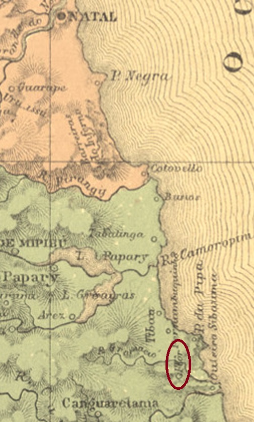
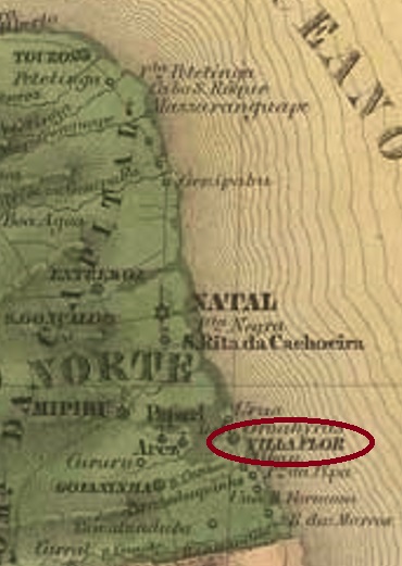
This village was originally an Indian settlement called Gramació, situated on the north bank of the Curimataú River, more than 80 km south of the future provincial capital Natal. In May 1755, the village rose to the status of a vila, but three years later it was moved to the neighbouring village of Canguaretama. In November 1892, Villa Flor became a district of Canguaretama and only regained political independence as a município in December 1963.
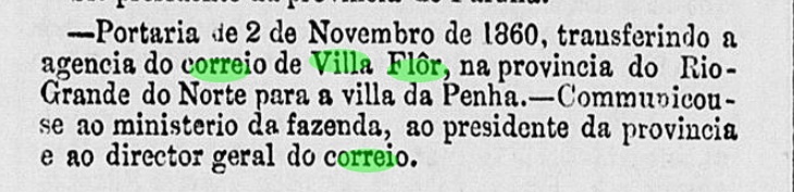
As Nova Monteiro writes in Administrações e Agencias Postaes do Brasil Imperio (Brasil Filatelico/RJ, 1934-5; Reprint SPP 1994-1999), there was a post office there as early as April 1818. With the move to Penha de Canguaretama (1858), the postal agency also moved there two years later, according to the capital’s official press:
Expediente do Ministerio do Imperio, 02.11.1860
Unfortunately, no 19th century postmark from this locality has been seen so far.
Villiers de l’Ile Adam: Carta (…) das Provincias do Rio Grande do Norte e Parahiba, 1848
Andere Namen: Gramació, Flor
Siehe auch Villa Flor (VRN-0240)
Diese Ortschaft war ursprünglich eine Indianersiedlung namens Gramació, die am Nordufer des Flusses Curimataú lag, über 80 km südlich der künftigen Provinzhauptstadt Natal entfernt. Im Mai 1755 stieg der Ort zur Vila auf, die aber drei Jahre später zum Nachbarort Canguaretama verlegt wurde. Im November 1892 wurde Villa Flor ein Distrikt von Canguaretama und erhielt erst im Dezember 1963 die politische Selbständigkeit als Município wieder.
Wie Nova Monteiro in Administrações e Agencias Postaes do Brasil Imperio (Brasil Filatelico/RJ, 1934-5; Reprint SPP 1994-1999) schreibt, gab es dort ein Postamt bereits ab April 1818. Mit dem Umzug nach Penha de Canguaretama (1858) zog die Postagentur zwei Jahre später auch dorthin, wie die Amtspresse der Hauptstadt berichtet:
Expediente do Ministerio do Imperio, 02.11.1860
Leider wurde bisher kein Poststempel des 19. Jahrhunderts aus dieser Ortschaft gesehen.
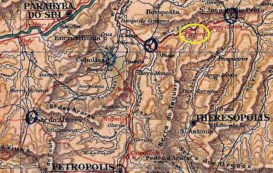
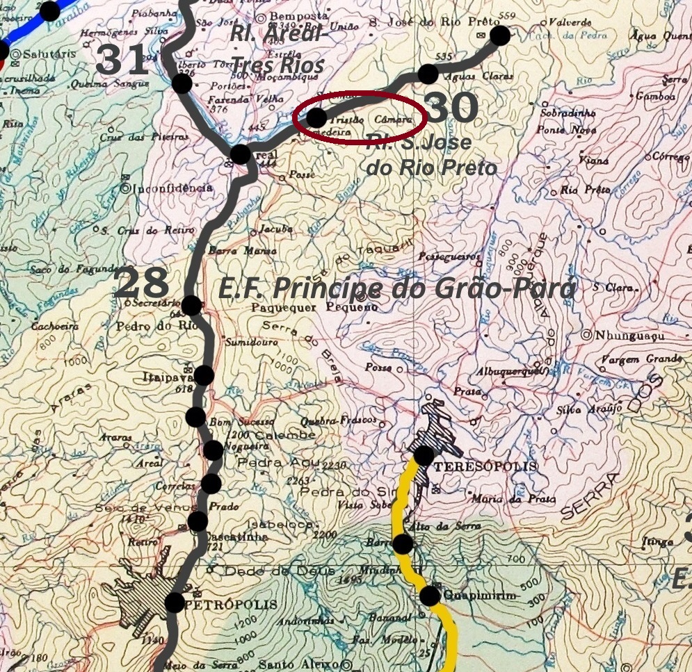
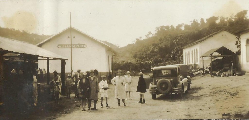
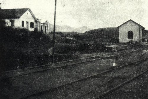
Figueira station was opened in November 1886 by the railway company E.F. do Grão-Pará (Rio Preto Branch) and was located on the south bank of the Rio Preto in the Município Petrópolis, 110 km north of the capital Rio de Janeiro. The name comes from the nearby Fazenda da Figueira. The line belonged to E.F. Leopoldina from 1890 until it was closed in 1947. From around 1935, the station was called Tristão Câmara, after the owner of the Fazenda da Figueira since 1853. Around 1945, the entire area around the station was flooded during the construction of a dam. Since December 1987, the lost railway station has been in the Município S. José do Vale do Rio Preto.
Around 1935 (Photo: N.N. on estacoesferroviarias.com.br)
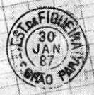
As Paulo Novaes writes in agenciaspostais.com.br, there had been a post office in the station since June 1886 with the imperial postmark FRJ-0500a (ill. by R. Koester in Carimbologia XIX):
FRJ-0500a (RK) 1887-1894ffagenciaspostais.com.br
Andere Namen: Est. Tristão Câmara (ca. 1935)
Der Bahnhof Figueira wurde im November 1886 von der Eisenbahngesellschaft E.F. do Grão-Pará (Rio Preto-Abzweigung) eröffnet und lag am Südufer des Rio Preto im Município Petrópolis, 110 km nördlich der Hauptstadt Rio de Janeiro. Der Name stammt von der nahe gelegenen Fazenda da Figueira. Die Strecke gehörte von 1890 bis zu ihrer Stilllegung 1947 der E.F. Leopoldina. Ab etwa 1935 hieß der Bahnhof Tristão Câmara, nach dem Besitzer der Fazenda da Figueira seit 1853. Um 1945 wurde das gesamte Gebiet um den Bahnhof beim Bau eines Staudamms überflutet. Seit Dezember 1987 befindet sich der verschwundene Bahnhof im Município de S. José do Vale do Rio Preto.
Um 1935 (Foto: N.N. auf estacoesferroviarias.com.br)
Wie Paulo Novaes in agenciaspostais.com.br schreibt, gab es im Bahnhof seit Juni 1886 ein Postamt mit dem kaiserlichen Poststempel FRJ-0500a (Abb. R. Koester in Carimbologia XIX):
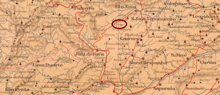
Other names: Est. Sant’Anna, Desembargador Faria Lemos
See also Faria Lemos (Est. E.F. Leopoldina, FMG-1170), Faria Lemos (Est. E.F. Juiz de Fora e Piau), (FMG-0970)
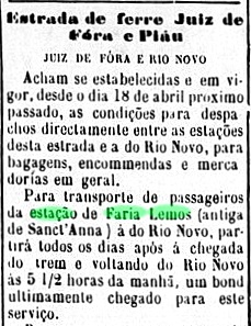
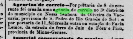
This station in the imperial province of Minas Gerais was opened in 1884 as Sant’Anna station by the railway company E.F. Juiz de Fora e Piau in the Município de Juiz de Fora, 230 km south of the provincial capital Ouro Preto. Around 1887, the station was renamed to Faria Lemos:
Pharol, 03/05/1887
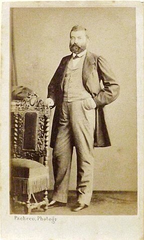
In 1888, the railway line was purchased by the 1974 E.F. Leopoldina and remained in its possession until it was closed in 1974. As the Leopoldina company already owned a Faria Lemos station (FMG-1170), the other station had to be renamed Ferreira Lage again, this time in honour of the entrepreneur Mariano Procópio Ferreira Lage (1821-1872), who had co-financed the E.F. Juiz de Fora e Piau.
Mariano Procópio Ferreira Lage (Wikipedia)Est. Ferreira Lage 1915 (Photo: Abilio Esteves, in Album de Juiz de Fora)
Today, neither the tracks nor the station building exist.
According to the Rio press, there was a post office at the station from October 1887:
Jornal do Commercio/RJ, 12/10/1887
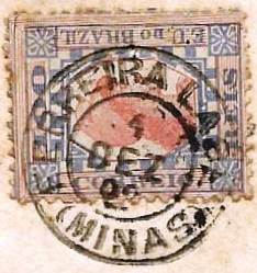
The oldest postmark under Ferreira Lage so far is FMG-1175a (ill. José Luiz Fevereiro)
FMG-1175a (JLF) 1892
For postmarks with Faria Lemos see FMG-0970 and FMG-1170.
Estado de Minas Geraes, 1910
Andere Namen: Est. Sant’Anna, Desembargador Faria Lemos
Siehe auch Faria Lemos (Est. E.F. Leopoldina, FMG-1170), Faria Lemos (Est. E.F. Juiz de Fora e Piau), (FMG-0970)
Dieser Bahnhof wurde 1884 als Bahnhof Sant’Anna von der Eisenbahngesellschaft E.F. Juiz de Fora e Piau eröffnet und lag im Município de Juiz de Fora, 230 km südlich der Provinzhauptstadt Ouro Preto. Um 1887 wurde die Station in Faria Lemos umbenannt:
Pharol, 03.05.1887
1888 wurde die Bahnlinie von der 1974 E.F. Leopoldina gekauft und blieb bis zu ihrer Stilllegung 1974 in deren Besitz. Da die Gesellschaft Leopoldina bereits eine Station Faria Lemos (FMG-1170) besaß, musste die Station erneut umbenannt werden, diesmal zu Ehren des Unternehmers Mariano Procópio Ferreira Lage (1821-1872), der die E.F. Juiz de Fora e Piau mitfinanziert hatte.
Mariano Procópio Ferreira Lage (Wikipedia)Est. Ferreira Lage 1915 (Foto: Abilio Esteves, im Album de Juiz de Fora)
Heute existieren weder die Gleise noch das Bahnhofsgebäude.
Wie der Presse von Rio zu entnehmen ist, befand sich seit Oktober 1887 ein Postamt am Bahnhof:
Jornal do Commercio/RJ, 12.10.1887
Der bisher älteste Poststempel mit Ferreira Lage ist FMG-1175a (JLF)
FMG-1175a (JLF) 1892
Für Poststempel mit Faria Lemos siehe FMG-0970 und FMG-1170.
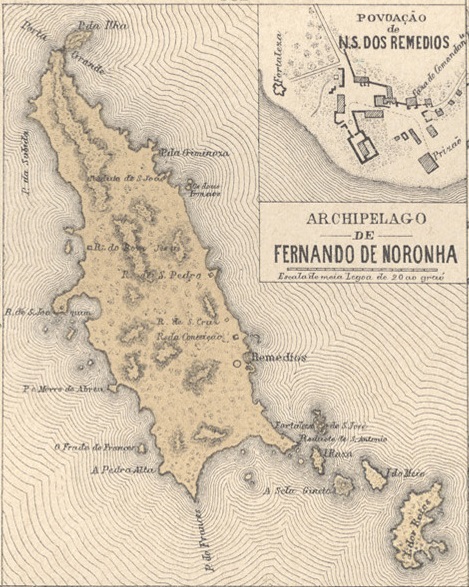
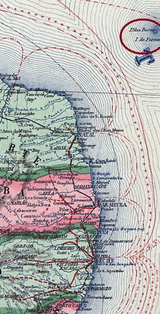
Fernando de Noronha consists of 21 islands in the Atlantic Ocean, 550 kilometres north-east of the state capital Recife. It has served as a prison since around 1740, as a military territory (Território federal militar) since 1942 and has been a district of the state of Pernambuco since October 1988. The name comes from Fernão de Loronha (1470-1540), a converted Jew from Portuguese nobility who helped to finance the colonisation of the island.
Fernão de Loronha (N.N.- XVII century)
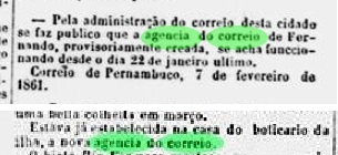
As Nova Monteiro writes in Administrações e Agencias Postaes do Brasil Imperio (Brasil Filatelico/RJ, 1934-5; reprint SPP 1994-1999), it was decided as early as October 1858 to set up a local post office. However, it was not until January 1861 that the agency was opened at the local apothecary.
Diário de Pernambuco, 08.02.1861
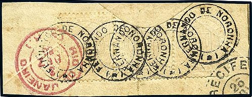
The first postmark has not yet been found. The French type FPE-0250b (Fig. Felipe Piccinini) is known:
FPE-0250b (FP) 1882ff-1890ffCarta da Republica dos Estados Unidos do Brazil, 1892
Der Archipel Fernando de Noronha besteht aus 21 Inseln im Atlantischen Ozean, 550 km nordöstlich der Landeshauptstadt Recife. Seit ca. 1740 diente er als Gefängnis, seit 1942 als Militärgebiet (Território federal militar) und seit Oktober 1988 ist er ein Distrito des Bundesstaates Pernambuco. Der Name stammt von Fernão de Loronha (1470-1540), einem konvertierten Juden aus portugiesischem Adel, der die Besiedlung der Insel mitfinanzierte.
Fernão de Loronha (N.N.- XVII Jahrhundert)
Wie Nova Monteiro in Administrações e Agencias Postaes do Brasil Imperio (Brasil Filatelico/RJ, 1934-5; Nachdruck SPP 1994-1999) schreibt, wurde bereits im Oktober 1858 beschlossen, vor Ort ein Postamt einzurichten. Es dauerte jedoch bis Januar 1861, bis die Agentur beim örtlichen Apotheker in Betrieb genommen wurde.
Diário de Pernambuco, 08.02.1861
Der erste Poststempel ist noch nicht gefunden worden. Bekannt ist der französische Typ FPE-0250b (Abb. Felipe Piccinini):
Villiers de l’Ile Adam: Carta (…) da Provincia da Bahia, 1848
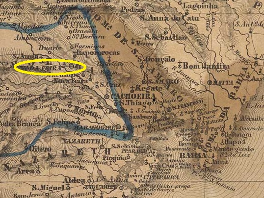
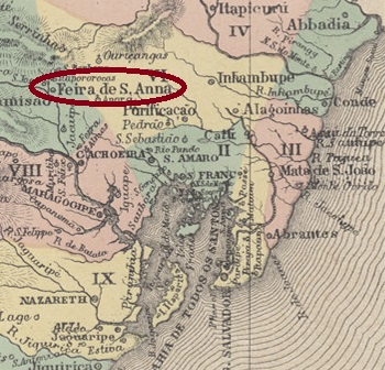
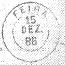
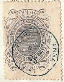
Today’s city of Feira de Santana, with over 600,000 inhabitants, was originally the Fazenda Sant’Anna dos Olhos d’Água in the Vila de Cachoeira area, 115 km north-west of the capital Salvador da Bahia. It became a Freguesia in 1696, a Vila in November 1832 and the Cidade Commercial da Feira de Sant’Anna in June 1873.
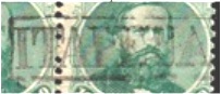
Two creation dates have been recorded for the local post office. Once in March 1836, as Nova Monteiro wrote in Administrações e Agencias Postaes do Brasil Imperio (Brasil Filatelico/RJ, 1934-5; reprint SPP 1994-1999). Then again in March 1846, according to R. Koester’s Carimbologia XIX. Seen in this light, only a few 19th century postmarks are known for this important city.
First and foremost is the pre-philatelic FBA-0365a, which was given the no. P-BA-07 in the RHM catalogue:
FBA-0365a (RK/RHM P-BA-07) 1839-1842
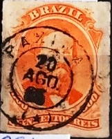
This was followed by a long period without known cancellations until FBA-0365b (fig. R. Koester, op. cit.) appeared:
FBA-0365b (RK) 1884-1901
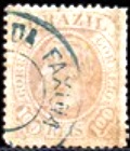
Towards the end of the Empire, the French type FBA-0365c (ill. from the Internet) was added:
FBA-0365c (EB) 1895
At least we still know of a mute cancel (illustration by Roberto Assef Jr.) from 1888:
1888 (RA)Atlas do Imperio do Brasil, 1868
Die heutige Stadt Feira de Santana mit über 600.000 Einwohnern war ursprünglich die Fazenda Sant’Anna dos Olhos d’Água im Gebiet der Vila de Cachoeira, 115 km nordwestlich der Hauptstadt Salvador da Bahia. 1696 wurde sie zur Freguesia, im November 1832 zur Vila und im Juni 1873 zur Cidade Commercial da Feira de Sant’Anna.
Für das örtliche Postamt sind zwei Gründungsdaten überliefert. Einmal im März 1836, wie Nova Monteiro in Administrações e Agencias Postaes do Brasil Imperio (Brasil Filatelico/RJ, 1934-5; Nachdruck SPP 1994-1999) schrieb. Dann noch einmal im März 1846, nach R. Koesters Carimbologia XIX. So gesehen sind nur wenige Poststempel aus dem 19. Jahrhundert für diese bedeutende Stadt bekannt.
An erster Stelle ist der vorphilatelistische FBA-0365a zu nennen, der im RHM-Katalog die Nr. P-BA-07 erhielt:
FBA-0365a (RK/RHM P-BA-07) 1839-1842
Es folgte eine lange Zeit ohne bekannte Stempel, bis FBA-0365b (Abb. R. Koester, op. cit.) erschien:
FBA-0365b (RK) 1884-1901
Gegen Ende des Kaiserreichs kam der französische Typ FBA-0365c (Abb. aus dem Internet) hinzu:
FBA-0365c (EB) 1895
Immerhin kennen wir noch einen stummen Stempel (Abb. Roberto Assef Jr.) von 1888:
J. M. Ribeiro Lisboa: Provincia de São Paulo, 1884
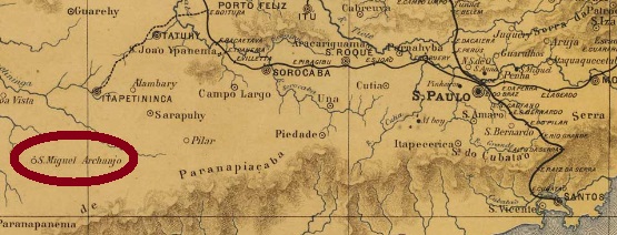
See also São Miguel Archanjo (SSP-1210)
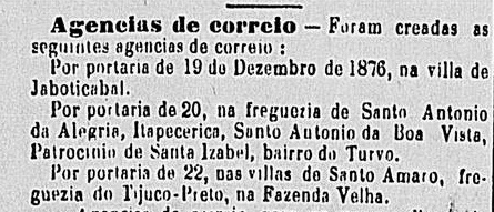
Fazenda Velha (Old Estate) was a settlement of the Vila de Itapetininga on the south bank of the Rio Turvo, a good 180 kilometres west of the provincial capital of São Paulo. In May 1877, the village was given its present name of São Miguel Archanjo when it became a freguesia. Since April 1889, São Miguel Arcanjo (as it is spelt today) has been an independent município.
According to the list of imperial post offices (Tabella das Agencias do Correio do Imperio, Rio de Janeiro, 1885), there had been a post office there since 1876, when the town’s name was still Fazenda Velha. This is confirmed by the regional press:
Correio Paulistano, 05.01.1877
So far, no imperial postmark with Fazenda Velha has appeared. For cancels with São Miguel Archanjo see SSP-1210.
Provincia de São Paulo, 1886
Siehe auch São Miguel Archanjo (SSP-1210)
Fazenda Velha (Altes Landgut) war eine Siedlung der Vila de Itapetininga am Südufer des Rio Turvo, gut 180 km westlich der Provinzhauptstadt São Paulo. Im Mai 1877 erhielt der Ort seinen heutigen Namen São Miguel Archanjo, als er eine Freguesia wurde. Seit April 1889 ist São Miguel Arcanjo (wie es heute geschrieben wird) ein eigenständiges Município.
Wie aus dem Verzeichnis der kaiserlichen Postämter (Tabella das Agencias do Correio do Imperio, Rio de Janeiro, 1885) hervorgeht, gab es dort seit 1876 ein Postamt, als der Ortsname noch Fazenda Velha lautete. Dies wird durch die regionale Presse bestätigt:
Correio Paulistano, 05.01.1877
Bisher ist kein kaiserlicher Poststempel mit Fazenda Velha aufgetaucht. Für Poststempel mit São Miguel Archanjo siehe SSP-1210.
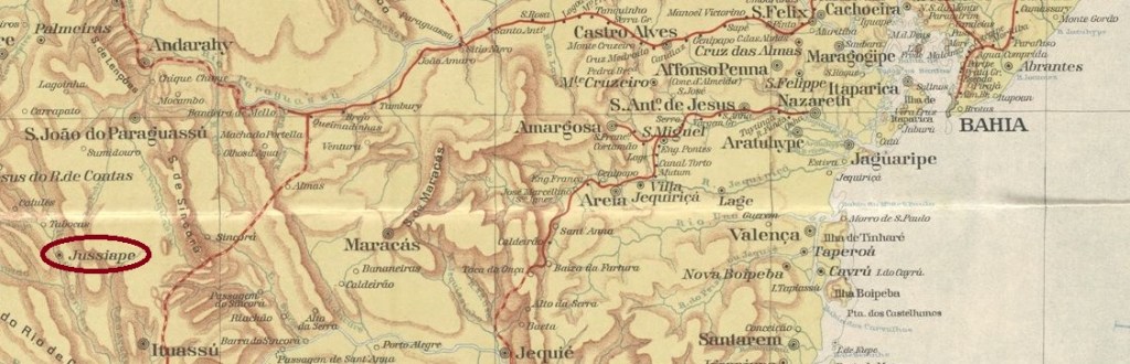
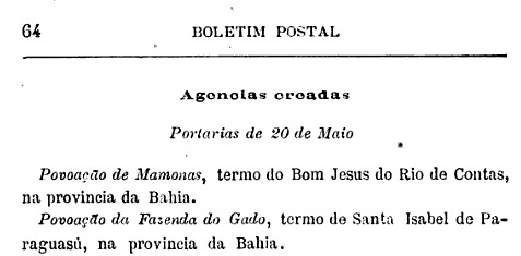
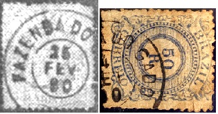
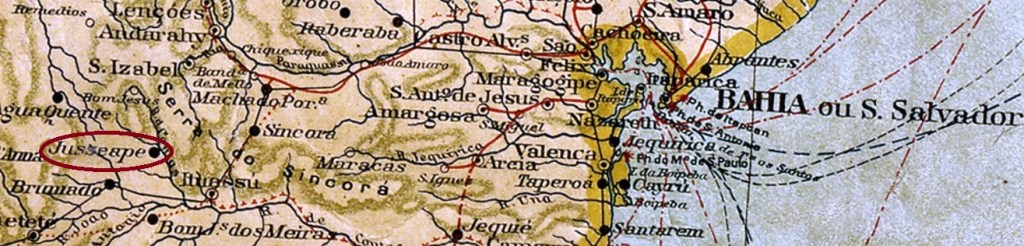
Fazenda do Gado was a settlement of the Vila de Sta. Izabel do Paraguaçu on the east bank of the Rio de Contas, 530 kilometres west of the provincial capital Salvador da Bahia. In July 1876, it was incorporated into the Vila de Brejo Grande as a freguesia and downgraded to Distrito do Gado around 1889. It was promoted again to Vila de Jussiape in October 1890, and in June 1920 it was again downgraded to Distrito in the Município de Barra da Estiva, and was not reclassified as Município de Jussiape until July 1962.
As can be seen from the postal bulletin (Boletim Postal) of 1889, there had been a post office there since May 1889.
Boletim Postal No. 2, June/1889
The only postmark from the 19th century to date is FBA-0355a (Fig. R. Koester in Carimbologia XIX – Alexandre Andrade):
FBA-0355a (RK-AA) 1890Nappa Geral do Brazil, 1911
Andere Namen: Gado, Jussiape (1890)
Fazenda do Gado war eine Siedlung der Vila de Sta. Izabel do Paraguaçu am Ostufer des Rio de Contas, 530 km westlich der Provinzhauptstadt Salvador da Bahia. Im Juli 1876 wurde sie als Freguesia in die Vila de Brejo Grande eingegliedert und um 1889 zum Distrito do Gado herabgestuft. Ein Wiederaufstieg als Vila de Jussiape erfolgte im Oktober 1890. Im Juni 1920 erfolgte die erneute Herabstufung als Distrito im Município de Barra da Estiva, die Wiederaufstufung als Município de Jussiape erfolgte erst im Juli 1962.
Wie aus dem Postbulletin (Boletim Postal) von 1889 hervorgeht, gab es dort seit Mai 1889 ein Postamt.
Boletim Postal Nr. 2, Juni/1889
Der bisher einzige Poststempel aus dem 19. Jahrhundert ist FBA-0355a (Abb. R. Koester in Carimbologia XIX – Alexandre Andrade):
Villiers de l’Ile Adam: Carta (…) da Provincia de São Paulo, 1847
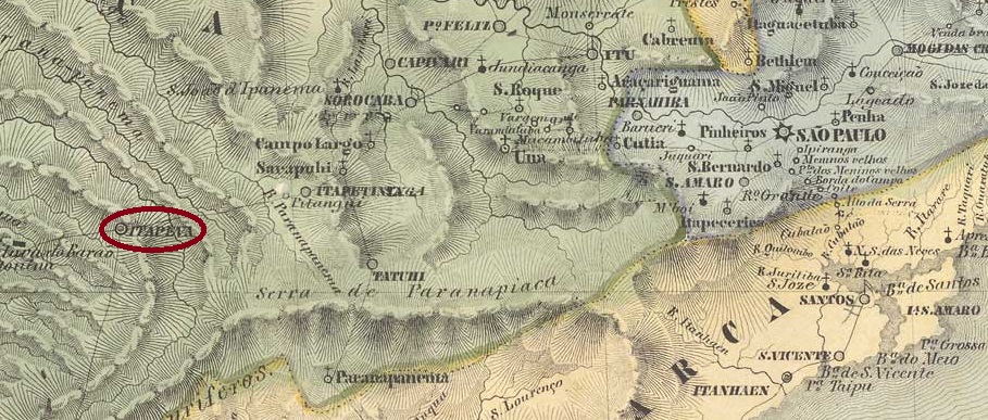
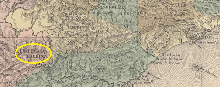
Other names: Sant’Anna, Itapeva da Faxina, Itapeva (1938)
The beautiful Indian word Itapeva means yellow stone, while the less charming Faxina is traditionally translated as bundle of brushwood and is used in modern-day Brazil when there is a lot of cleaning and tidying up to do. However, the origin of the place probably goes back to a certain Facchina family, who are said to have run a resting place for drovers (tropeiros) there in the 18th century. In any case, the Freguesia de Itapeva de (or do) Faxina was founded in June 1766. It belonged to the Vila de Sorocaba and was located on the east bank of the Taquary, 290 kilometres west of the future provincial capital of São Paulo. Three years later it was elevated to Vila de Sant’Anna da Faxina, which was renamed Itapeva da Faxina in March 1838 and declared Cidade de Faxina in July 1861. The município has been called Itapeva again since November 1938.
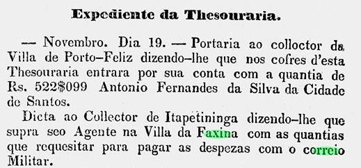
Two creation dates have been found for the local post office. Once in April 1828, as Nova Monteiro writes in Administrações e Agencias Postaes do Brasil Imperio (Brasil Filatelico/RJ, 1934-5; reprint SPP 1994-1999). Then again in 1844, as can be seen from the Directory of Imperial Post Offices (Tabella das Agencias do Correio do Imperio, Rio de Janeiro, 1885). Between the two periods of operation, a military postal courier was also active on the São Paulo-Curitiba route, as can be seen from the regional press:
A Phenix, 26/02/1840
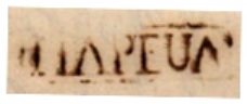
So far, seven Faxina or Itapeva postmarks have been found for the 19th century, starting with the pre-philatelic ISP-1665a (fig. Mário Celso Orsi Jr.), which is registered in the RHM catalogue under P-SP-14:
ISP-1665a (MO, RHM P-SP-14) 1833-1836ff
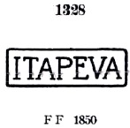
It was followed by ISP-1665b, known through P. Ayres’s Catálogo de Carimbos Brasil-Império (S. Paulo, 1937, 1942) under no. 1328:
ISP-1665b (P.A. 1328) 1843ff-1864
A later variant is ISP-1665c (illus. Mário Celso Orsi Jr.):
ISP-1665c (MO) 1866ff-1877ff
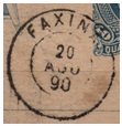
All Faxina cancels are circular, starting with FSP-0530a (fig. Mario Celso Orsi Jr.):
FSP-0530a (MO) 1877-1891
The French type FSP-0530b (illustration from the Internet) was also used at about the same time:
FSP-0530b (EB) 1880-1889
In the meantime, the rare ISP-1715a also appeared (ill. Mario Celso Orsi Jr.):
ISP-1715a (MO) 1883ff
FSP-0530c (image from the Internet) is probably already republican:
FSP-0530c (EB) 1890-1895Atlas do Imperio do Brasil, 1868
Andere Namen: Sant’Anna, Itapeva da Faxina, Itapeva (1938)
Das schöne indianische Wort Itapeva bedeutet gelber Stein, während das weniger charmante Faxina traditionell mit Reisigbündel übersetzt wird und im heutigen Brasilien verwendet wird, wenn es viel zu putzen und aufzuräumen gibt. Der Ursprung des Ortes geht jedoch vermutlich auf eine bestimmte Familie Facchina zurück, die hier im 18. Jahrhundert eine Raststätte für Viehtreiber (Tropeiros) betrieben haben soll. Jedenfalls wurde im Juni 1766 die Freguesia de Itapeva de (oder do) Faxina gegründet. Sie gehörte zur Vila de Sorocaba und lag am Ostufer des Taquary, 290 km westlich der späteren Provinzhauptstadt São Paulo. Drei Jahre später erfolgte die Erhebung zur Vila de Sant’Anna da Faxina, die im März 1838 in Itapeva da Faxina umbenannt und im Juli 1861 zur Cidade de Faxina erklärt wurde. Seit November 1938 heißt der Município wieder Itapeva.
Für das örtliche Postamt wurden zwei Gründungsdaten gefunden. Einmal im April 1828, wie Nova Monteiro in Administrações e Agencias Postaes do Brasil Imperio (Brasil Filatelico/RJ, 1934-5; Reprint SPP 1994-1999) schreibt. Dann wieder 1844, wie aus dem Verzeichnis der kaiserlichen Postämter (Tabella das Agencias do Correio do Imperio, Rio de Janeiro, 1885) hervorgeht. Zwischen den beiden Betriebsperioden war auch ein militärischer Postkurier auf der Strecke São Paulo-Curitiba aktiv, wie aus der regionalen Presse hervorgeht:
A Phenix, 26.02.1840
Bisher wurden sieben Faxina- bzw. Itapeva-Poststempel für das 19. Jahrhundert gefunden, beginnend mit dem vorphilatelistischen ISP-1665a (Abb. Mário Celso Orsi Jr.), der im RHM-Katalog unter P-SP-14 registriert ist:
ISP-1665a (MO, RHM P-SP-14) 1833-1836ff
Ihm folgte ISP-1665b, bekannt durch P. Ayres’ Catálogo de Carimbos Brasil-Império (S. Paulo, 1937, 1942) unter Nr. 1328:
ISP-1665b (P.A. 1328) 1843ff-1864
Eine spätere Variante ist ISP-1665c (Abb. Mário Celso Orsi Jr.):
ISP-1665c (MO) 1866ff-1877ff
Alle Stempel von Faxina sind kreisförmig, beginnend mit FSP-0530a (Abb. Mario Celso Orsi Jr.):
FSP-0530a (MO) 1877-1891
Etwa zur gleichen Zeit wurde auch der französische Typ FSP-0530b (Abb. aus dem Internet) verwendet:
FSP-0530b (EB) 1880-1889
Zwischenzeitlich tauchte auch der seltene ISP-1715a auf (Abb. Mario Celso Orsi Jr.):
ISP-1715a (MO) 1883ff
FSP-0530c (Abb. aus dem Internet) dürfte bereits republikanisch sein:
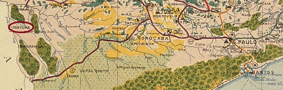
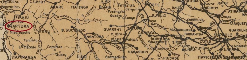
The chapel N. Sra. das Dores de Fartura was built in 1870 and belonged to the Vila de S. Sebastião do Tijuco Preto, near the provincial border with Paraná, 350 kilometres west of the capital São Paulo. In February 1884, the village became a freguesia of the Vila de S. João Baptista do Rio Verde and in March 1891 it was elevated to an independent Vila.
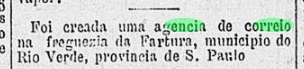
According to the regional press, there had been a post office since June 1884:
Gazeta de Noticias, 18/06/1884
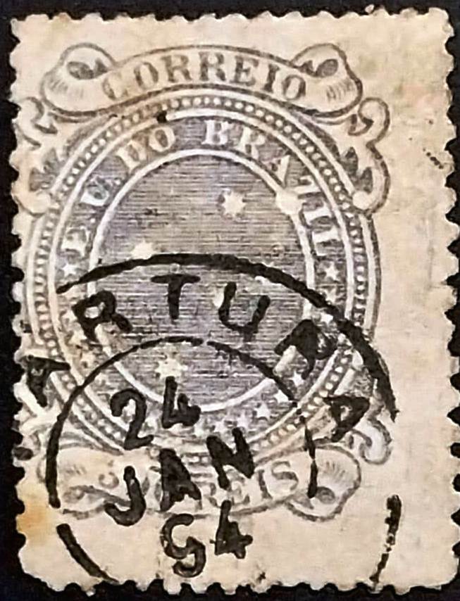
The oldest postmark to date is the double circle FSP-0525a (coll. Djalma Lacalendola):
FSP-0525a (DL) 1894Arthur D. Ribeiro: Estado de São Paulo, 1924
Die Kapelle N. Sra. das Dores de Fartura wurde 1870 errichtet und gehörte zur Vila de S. Sebastião do Tijuco Preto, nahe der Provinzgrenze zu Paraná, 350 km westlich der Hauptstadt São Paulo. Im Februar 1884 wurde der Ort eine Freguesia der Vila de S. João Baptista do Rio Verde und im März 1891 wurde er zur eigenständigen Vila erhoben.
Wie aus der regionalen Presse hervorgeht, gab es seit Juni 1884 ein Postamt:
Gazeta de Noticias, 18.06.1884
Der bisher älteste Poststempel ist der Doppelkreis FSP-0525a (Samml. Djalma Lacalendola):
Carta da Republica dos Estados Unidos do Brazil, 1892
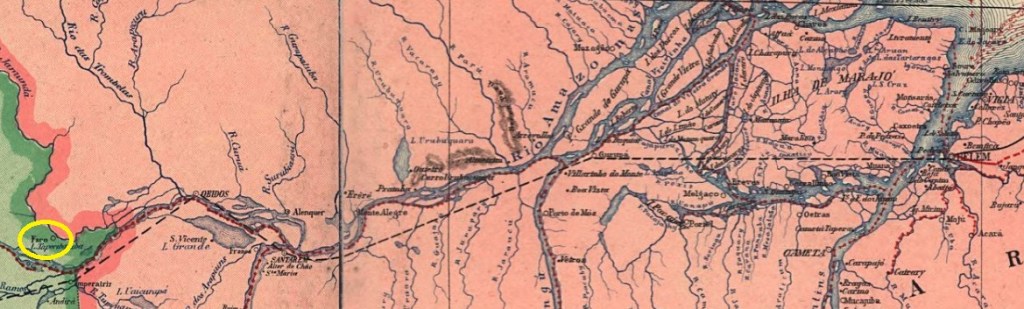
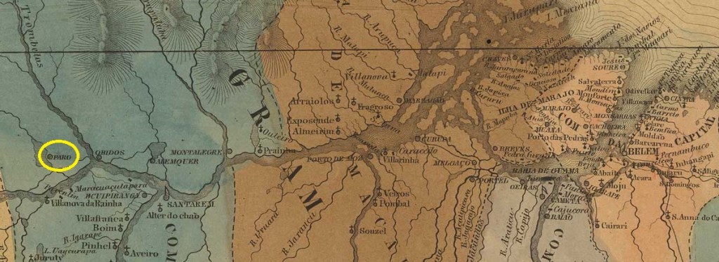
The former Indian settlement was looked after by the Capuchins of the Mission N. Sra. da Piedade at the confluence of the Paracatu and Nhamundá rivers near the current state border between Pará and Amazonas. The village was declared Vila de S. João Baptista do Faro as early as 1758. In April 1865, the town was moved further south, where the Nhamundá flows into the Amazon, over 1,500 kilometres west of the provincial capital Belém do Pará. Faro has been a city since July 1895, and the journey to Belém still takes over 30 hours by boat and bus.
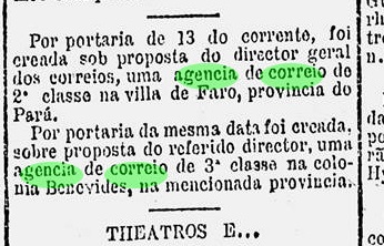
The local post office was opened in January 1882, as reported by the press in Rio:
Gazeta de Noticias/RJ, 14.01.1882
We have not yet seen an imperial postmark from Faro in Pará.
Villiers de l’Ile Adam: Carta (…) das Provincias do Grão Pará e Alto Amazonas, 1850
Die ehemalige Indianersiedlung wurde von den Kapuzinern der Mission N. Sra. da Piedade am Zusammenfluss der Flüsse Paracatu und Nhamundá nahe der heutigen Staatsgrenze zwischen Pará und Amazonas betreut. Bereits 1758 wurde der Ort zur Vila de S. João Baptista do Faro erklärt. Im April 1865 wurde der Ort weiter nach Süden verlegt, wo der Nhamundá in den Amazonas mündet, über 1.500 km westlich der Provinzhauptstadt Belém do Pará. Seit Juli 1895 ist Faro eine Stadt, die Reise nach Belém dauert auch heute noch mit Schiff und Bus über 30 Stunden.
Das örtliche Postamt wurde im Januar 1882 eröffnet, wie die Presse in Rio berichtete:
Gazeta de Noticias/RJ, 14.01.1882
Bisher haben wir noch keinen kaiserlichen Poststempel aus Faro in Pará gesehen.