Villiers de l’Ile Adam: Carta (…) da Provincia do Rio de Janeiro, 1850
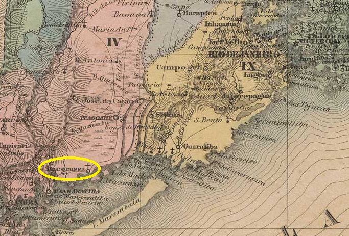
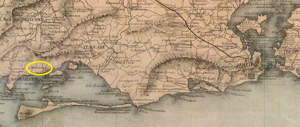
The Freguesia de Sant’Anna do Itacurussá was founded in December 1836. It belonged to the Vila de Mangaratiba and was idyllically situated on the beach opposite the island of Itacurussá, 90 kilometres west of the capital Rio de Janeiro. Not much happened after that: Itacurussá became a district of the Município de S. João Marcos in May 1892 and returned to the newly founded Município de Mangaratiba seven months later.
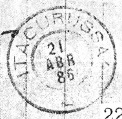
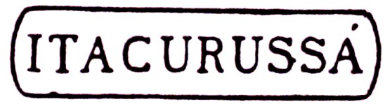
As Nova Monteiro writes in Administrações e Agencias Postaes do Brasil Imperio (Brasil Filatelico/RJ, 1934-5; reprint SPP 1994-1999), there had been a post office there since August 1837. The oldest postmark to date, IRJ-0670a, was given the no. 1325 in P. Ayres’ Catálogo de Carimbos Brasil-Império (S. Paulo, 1937, 1942):
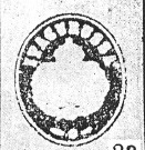
Two postmarks followed as double circles, first IRJ-0670b (fig. Felipe Piccinini):
IRJ-0670b (FP) 1877-1884
Then also IRJ-0670c (fig. R. Koester, in Carimbologia XXIII):
IRJ-0670c (RK) 1886
Koester also showed the postmark with the imperial seal IRJ-0670d:
IRJ-0670d (RK)Colton & Colton: Provincia do Rio de Janeiro, 1866
Bereits im Dezember 1836 wurde die Freguesia de Sant’Anna do Itacurussá gegründet, sie gehörte zur Vila de Mangaratiba und lag idyllisch am Strand gegenüber der Insel Itacurussá, 90 km westlich der Hauptstadt Rio de Janeiro. Danach passierte nicht viel: Itacurussá wurde im Mai 1892 ein Distrito des Município de S. João Marcos und kehrte sieben Monate später zum neu gegründeten Município de Mangaratiba zurück.
Wie Nova Monteiro in Administrações e Agencias Postaes do Brasil Imperio (Brasil Filatelico/RJ, 1934-5; Reprint SPP 1994-1999) schreibt, gab es dort ein Postamt seit August 1837. Der bisher älteste Poststempel IRJ-0670a erhielt die Nr. 1325 in P. Ayres‘ Catálogo de Carimbos Brasil-Império (S. Paulo, 1937, 1942):
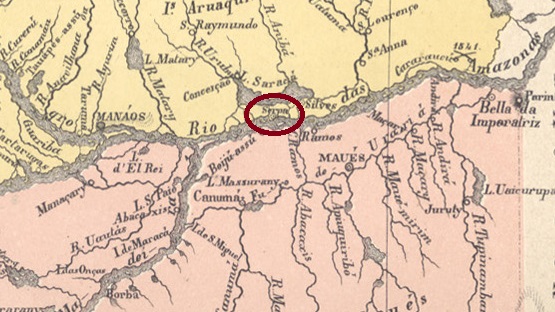
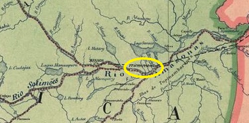
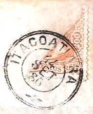
Nossa Senhora do Rosário de Serpa was the name of the villa that is said to have existed as early as 1759 on the north bank of the Amazon River, about 270 km east of the later provincial capital of Manaus. In 1833, the village was demoted to a district of Manaus, but in December 1857, it was again granted villa status. Since April 1874, the locality has been a town called Itacoatiara. The word from the Tupi language means painted stone.
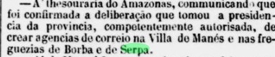
Two opening years were found for the local post office. Nova Monteiro (Administrações e Agencias Postaes do Brasil Imperio, in Brasil Filatelico/RJ, 1934-5; Reprint SPP 1994-1999) writes September 1852 for it, while the Imperial Mail Register (Tabella das Agencias do Correio do Imperio, Rio de Janeiro, 1885) lists this agency from 1855 on. The second date is confirmed by the Rio de Janeiro press:
Jornal do Commercio/RJ, 21.09.1855
The only postmark from the imperial period to date is IAM-0050a (Coll. Fuad Ferreira Fo.):
IAM-0050a (FF) 1886Carta da Reüublica dos Estados Unidos do Brazil, 1892
Siehe auch Serpa (SAM-0115)
Nossa Senhora do Rosário de Serpa hieß die Villa, die bereits 1759 am Nordufer des Amazonas existiert haben soll, ca. 270 km östlich der späteren Provinzhauptstadt Manaus entfernt. Im Jahr 1833 wurde dann die Ortschaft zum Distrikt von Manaus degradiert, erhielt aber im Dezember 1857 erneut den Villa-Status. Seit April 1874 ist der Ort eine Stadt namens Itacoatiara. Das Wort aus der Tupi-Sprache bedeutet bemalter Stein.
Zwei Eröffnungsjahre wurden fürs örtliche Postamt gefunden. Nova Monteiro (Administrações e Agencias Postaes do Brasil Imperio, in Brasil Filatelico/RJ, 1934-5; Reprint SPP 1994-1999) schreibt dafür den September 1852, während das Verzeichnis der kaiserlichen Postämter (Tabella das Agencias do Correio do Imperio, Rio de Janeiro, 1885) diese Agentur ab 1855 auflistet. Das zweite Datum wird durch die Presse aus Rio de Janeiro bestätigt:
Jornal do Commercio/RJ, 21.09.1855
Der bisher einzige Poststempel der Kaiserzeit ist IAM-0050a (Samml. Fuad Ferreira Fo.):
Colton & Colton: Provincia do Rio de Janeiro, 1866
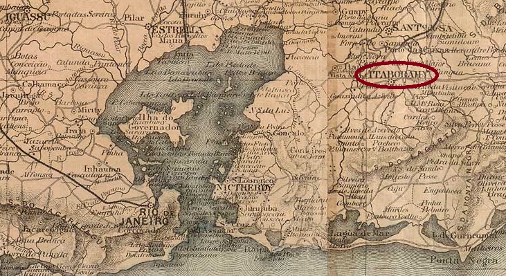
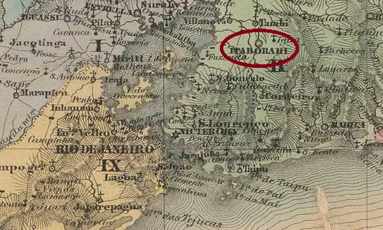
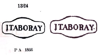
The settlement was founded in 1672 with the construction of the chapel of S. João Baptista de Itaborahy (also written Itaboray) on the east bank of the Rio da Vargem, 50 kilometres north-east of the future capital Rio de Janeiro. In June 1696, it was declared the Freguesia de S. João Baptista de Itaborahy, which belonged to the Vila de Sto. Antonio de Sá. In May 1833 it became a Vila and in January 1890 a town.
Nova Monteiro writes in Administrações e Agencias Postaes do Brasil Imperio (Brasil Filatelico/RJ, 1934-5; reprint SPP 1994-1999) that there had been a post office there since August 1829. The oldest postmark to date is IRJ-0665a, which was given the number 1324 by Paulo Ayres in Catálogo de Carimbos Brasil-Império (S. Paulo, 1937, 1942). However, the dot at the bottom right is missing in his illustration, as can be seen in the Catálogo ilustrado dos carimbos sobre os olhos-de-boi (4a. ed., Porto Alegre, 2017) by Henrique B. Ferreira:
IRJ-0665a (P.A. 1324 – RHM P-RJ-11, recte HBF) ca. 1840-1876ff
This was followed by the double circle IRJ-0665b (ill. R. Koester, in Carimbologia XXIII):
IRJ-0665b (RK) 1887
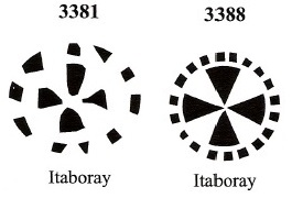
Two mute cancellations by James Dingler and Klerman W. Lopes are also known from Itaborahy (Mute Cancellations of the Brazil Empire / Carimbos Mudos do Brasil Império, Brazil Philatelic Association, Rio de Janeiro, 2000):
BPA 3381 (1866ff) – 3388Villiers de l’Ile Adam: Carta (…) da Provincia do Rio de Janeiro, 1850
Die Siedlung entstand 1672 mit dem Bau der Kapelle S. João Baptista de Itaborahy (auch Itaboray geschrieben) am Ostufer des Rio da Vargem, 50 km nordöstlich der späteren Hauptstadt Rio de Janeiro. Im Juni 1696 wurde sie zur Freguesia de S. João Baptista de Itaborahy erklärt, die zur Vila de Sto. Antonio de Sá gehörte. Im Mai 1833 wurde es zur Vila und im Januar 1890 zur Stadt erhoben.
Nova Monteiro schreibt in Administrações e Agencias Postaes do Brasil Imperio (Brasil Filatelico/RJ, 1934-5; Reprint SPP 1994-1999), dass es dort seit August 1829 ein Postamt gab. Der bisher älteste Poststempel ist IRJ-0665a, der von Paulo Ayres in Catálogo de Carimbos Brasil-Império (S. Paulo, 1937, 1942) die Nummer 1324 erhielt. Allerdings fehlt in seiner Abbildung der Punkt rechts unten, wie man dem Catálogo ilustrado dos carimbos sobre os olhos-de-boi (4a. ed., Porto Alegre, 2017) von Henrique B. Ferreira entnehmen kann:
IRJ-0665a (P.A. 1324 – RHM P-RJ-11, recte HBF) ca. 1840-1876ff
Es folgte der Doppelkreis IRJ-0665b (Abb. R. Koester, in Carimbologia XXIII):
IRJ-0665b (RK) 1887
Aus Itaborahy sind auch zwei stumme Abstempelungen von James Dingler und Klerman W. Lopes bekannt (Mute Cancellations of the Brazil Empire / Carimbos Mudos do Brasil Império, Brazil Philatelic Association, Rio de Janeiro, 2000):
Villiers de l’Ile Adam: Carta (…) da Provincia de Minas Geraes, 1849
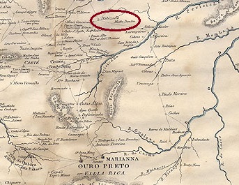
Other names: Itabira de Matto Dentro, Getúlio Vargas (1943-1947)
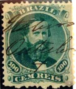
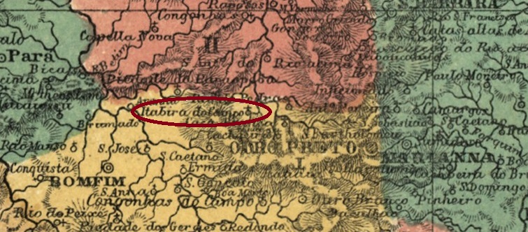
The Freguesia de N. Sra. do Rosário de Itabira, which had existed since January 1827, belonged to the Vila de Caeté and was located on the north bank of the Rio do Peixe, 150 kilometres north of the provincial capital Ouro Preto. It was elevated to a vila in June 1833 and to a town in October 1848. In December 1943, the município was renamed in honour of the dictator Getúlio Vargas, but the old place name returned in March 1947. The word Itabira comes from the Tupi-Guarani and means shiny stone. It refers to the iron ore that brought prosperity to the municipality for a long time.
The Catálogo Enciclopédico RHM (S. Paulo, 1999) states that there has been a post office since December 1848. However, as the regional press reports on postal traffic to and from Itabira in August 1831 at the earliest, an earlier date of the establishment of the local post office in March 1829 is probably more accurate. This date is supported by R. Koester (Carimbologia XXIII), Paula Sobrinho (História Postal de Minas Gerais, Belo Horizonte, 1997) and Nova Monteiro (Administrações e Agencias Postaes do Brasil Imperio, in Brasil Filatelico/RJ, 1934-5; reprint SPP 1994-1999).
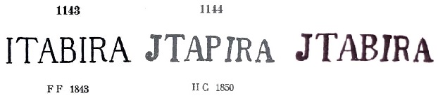
Two illustrations of the oldest postmark IMG-1345a can be found in P. Ayres’ Catálogo de Carimbos Brasil-Império (S. Paulo, 1937, 1942). However, the correct illustration is a mixture of both, as Henrique B. Ferreira shows in Catálogo ilustrado dos carimbos sobre os olhos-de-boi (4a. ed., Porto Alegre, 2017):
IMG-1345a (P.A. 1143-1144 – recte HBF) 1830-1862
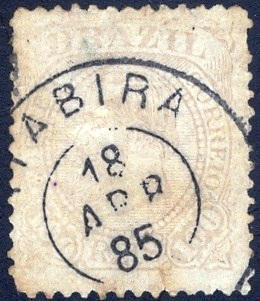
Sometime in the 1860s, this cancel stamp broke and a replacement was not obtained in time. The stamps in Itabira were therefore cancelled by hand for at least 10 years. An illustration of this can also be found in P. Ayres (op. cit.), here together with an example from the Paulo Corchaki collection:
1866ff-1876 (P.A. p. 147 – P. Corchaki)
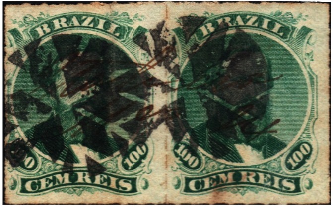
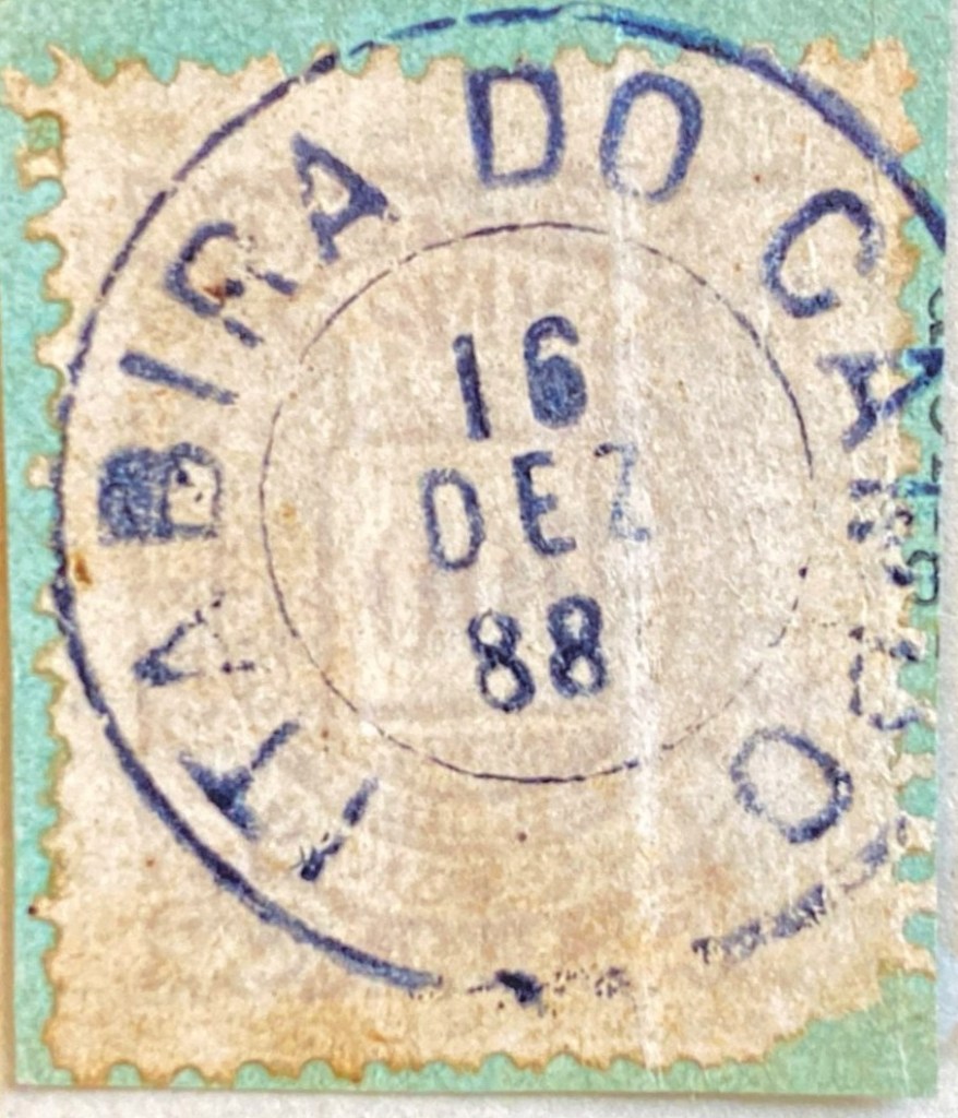
Only in the last decade of the Empire was the following circle cancellation IMG-1345b (Márcio Protzner collection) used:
IMG-1345b (MP) 1883-1892
The following mute cancellation (Carlos A. C. Balata Collection) probably also originates from Itabira:
1876ff (CB)Province of Minas Geraes, 1835
Andere Namen: Itabira de Matto Dentro, Getúlio Vargas (1943-1947)
Die seit Januar 1827 bestehende Freguesia de N. Sra. do Rosário de Itabira gehörte zur Vila de Caeté und lag am Nordufer des Rio do Peixe, 150 km nördlich der Provinzhauptstadt Ouro Preto. Die Erhebung zur Vila erfolgte im Juni 1833, die zur Stadt im Oktober 1848. Im Dezember 1943 wurde der Município zu Ehren des Diktators Getúlio Vargas umbenannt, aber im März 1947 kehrte der alte Ortsname zurück. Das Wort Itabira stammt aus dem Tupi-Guarani und bedeutet glänzender Stein. Es bezieht sich auf das Eisenerz, das der Gemeinde lange Zeit zu Wohlstand verhalf.
Im Catálogo Enciclopédico RHM (S. Paulo, 1999) ist zu lesen, dass es seit Dezember 1848 ein Postamt gab. Da jedoch in der regionalen Presse schon ab August 1831 über Postverkehr von und nach Itabira berichtet wird, dürfte das frühere Datum der Gründung des örtlichen Postamtes im März 1829 zutreffender sein. Dieses Datum wird von R. Koester (Carimbologia XXIII), Paula Sobrinho (História Postal de Minas Gerais, Belo Horizonte, 1997) und Nova Monteiro (Administrações e Agencias Postaes do Brasil Imperio, in Brasil Filatelico/RJ, 1934-5; Nachdruck SPP 1994-1999) vertreten.
Vom ältesten Poststempel IMG-1345a sind zwei Abbildungen in P. Ayres‘ Catálogo de Carimbos Brasil-Império (S. Paulo, 1937, 1942) zu finden. Die korrekte Abbildung dürfte jedoch eine Mischung aus beiden sein, wie Henrique B. Ferreira in Catálogo ilustrado dos carimbos sobre os olhos-de-boi (4a. ed., Porto Alegre, 2017) zeigt:
IMG-1345a (P.A. 1143-1144 – recte HBF) 1830-1862
Irgendwann in den 1860er Jahren ging dieser Stempel kaputt, und es wurde nicht rechtzeitig Ersatz beschafft. Daher wurden die Marken in Itabira mindestens 10 Jahre lang von Hand gestempelt. Eine Abbildung davon findet sich auch bei P. Ayres (op. cit.), hier zusammen mit einem Beispiel aus der Sammlung Paulo Corchaki:
1866ff-1876 (P.A. S. 147 – P. Corchaki)
Erst im letzten Jahrzehnt des Kaiserreichs wurde der folgende Kreisstempel IMG-1345b (Sammlung Márcio Protzner) verwendet:
IMG-1345b (MP) 1883-1892
Aus Itabira stammt vermutlich auch die folgende stumme Abstempelung (Samml. Carlos A. C. Balata):
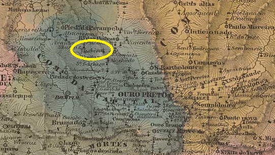
The Freguesia de N. Sra. da Boa Viagem de Itabira do Campo, 45 km north-west of Villa Rica de Albuquerque (later the provincial capital of Ouro Preto), had existed since April 1745. In September 1891 it became a distrito in the Município Ouro Preto. In September 1923, it was elevated to Município de Itabirito (presumably to avoid confusion with the other Itabira ‘do Matto Dentro’), which was elevated to city status two years later.
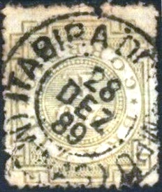
R. Koester (Carimbologia XXIII) and Paula Sobrinho (História Postal de Minas Gerais, Belo Horizonte, 1997) agree that there has been a post office there since November 1876. Presumably the postmark was not delivered in time, as Koester (op. cit.) reports a handwritten cancellation from 1883. The oldest postmark to date, IMG-1350a (fig. F. Piccinini), is also in blue and bears dates from 1886:
IMG-1350a (FP) 1886-1889
This was followed by IMG-1350b (illustration from the Internet):
IMG-1350b (EB) 1889-1891Villiers de l’Ile Adam: Carta (…) da Provincia de Minas Geraes (1849)
Andere Namen: Itabirito (1923)
Seit April 1745 bestand die Freguesia de N. Sra. da Boa Viagem de Itabira do Campo, 45 km nordwestlich von Villa Rica de Albuquerque (der späteren Provinzhauptstadt Ouro Preto). Im September 1891 wurde es ein Distrito im Município Ouro Preto. Im September 1923 erfolgte die Erhebung zum Município de Itabirito (vermutlich um Verwechslungen mit dem anderen Itabira „do Matto Dentro“ zu vermeiden), das zwei Jahre später zur Stadt erhoben wurde.
R. Koester (Carimbologia XXIII) und Paula Sobrinho (História Postal de Minas Gerais, Belo Horizonte, 1997) sind sich einig, dass es dort seit November 1876 ein Postamt gab. Vermutlich wurde der Poststempel nicht rechtzeitig geliefert, denn Koester (a.a.O.) berichtet von einer handschriftlichen Entwertung aus dem Jahr 1883. Der bisher älteste Poststempel IMG-1350a (Abb. F. Piccinini) kommt ebenfalls in blau vor und trägt bisher Daten ab 1886:
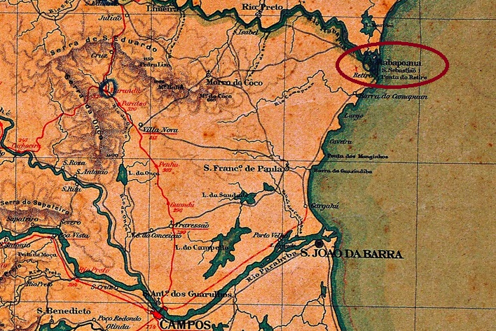
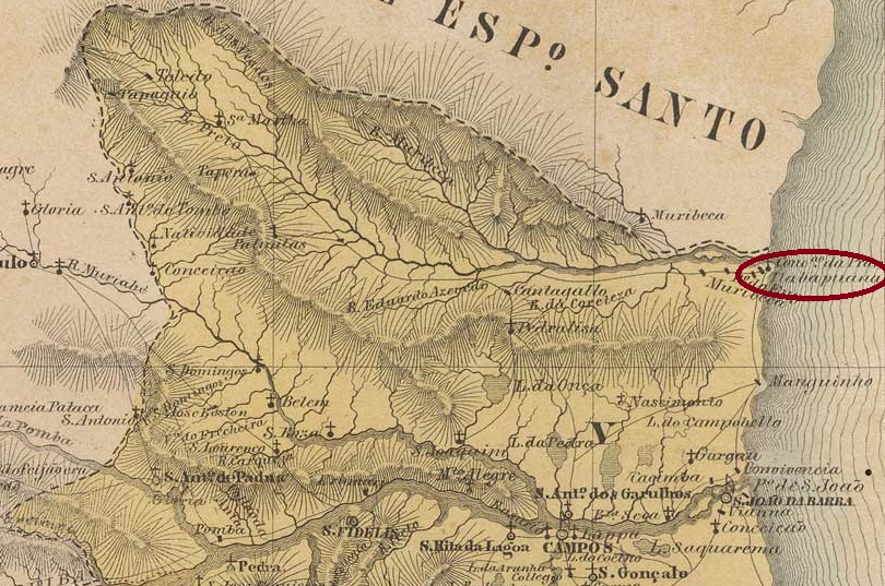
São Sebastião de Itabapoana was a small arraial on the south bank of the mouth of the Itabapoana on the provincial border between Rio de Janeiro and Espírito Santo, 360 km northeast of the capital Rio de Janeiro. In October 1857, it became a freguesia in the newly founded Município de S. João da Barra. Since January 1995 it has been the district of Itabapoana in the Município S. Francisco do Itabapoana.
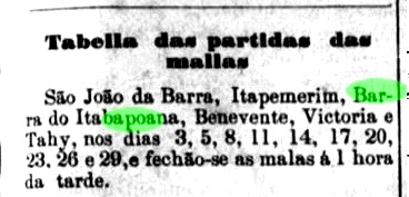
Two creation dates have been found for the local post office. Nova Monteiro mentions June 1853 in Administrações e Agencias Postaes do Brasil Imperio (Brasil Filatelico/RJ, 1934-5; reprint SPP 1994-1999). Paulo Novaes writes in agenciaspostais.com.br about the creation of a postal agency in Barra de Itabapoana ‘around 1885’, while the regional press reports 10 postal connections per month between Campos and Barra do Itabapoana as early as 1879:
Monitor Campista, 18/06/1879
R. Koester (Carimbologia XXIII) believed that Itabapoanna and Barra de Itabapoana were the same agency, as his postmark dates for Itabapoanna extend to about 1885, after which his postmarks begin with Barra do Itabapoana. In the meantime, later postmarks from Itabapoanna have emerged (see below), but the fact that both agencies are never listed together in any post office directory of the Empire speaks in favour of his thesis. Furthermore, the alternative places (Bom Jesus de Itabapoanna/BRJ-0200 and Estação de Itabapoana/IRJ-0661) are out of the question, as their post offices were established later.
The oldest postmark raises a further mystery, as the only known example of it can be seen on a forged letter: Is the postmark also forged or was a genuine postmark imitated here?
Forged letter, 1843 (ill. R. Koester, Carimbologia XXIII)
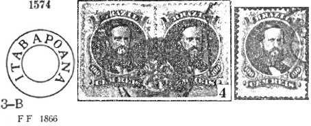
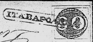
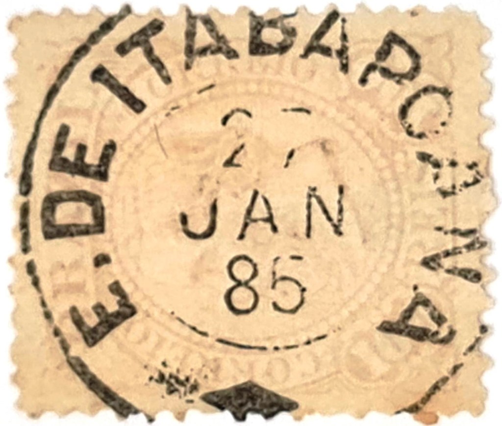
The next Itabapoana postmark is also problematic. P. Ayres shows IRJ-0660a in his Catálogo de Carimbos Brasil-Império (S. Paulo, 1937, 1942) under no. 1574, but Koester (op.cit.) shows that Ayres’ illustration has considerable flaws and that the cancel also occurs in dark violet:
IRJ-0660a (P.A. 1574 – recte RK) 1866ff
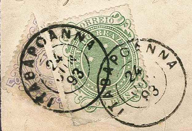
The following IRJ-0660b (fig. Corinphila Auctions) also exists in green and blue:
IRJ-0660b (CO) 1880-1893
For postmarks with BARRA DE ITABAPOANNA see BRJ-0120.
Villiers de l’Ile Adam: Carta (…) da Provincia do Rio de Janeiro, 1850
Andere Namen: S. Sebastião de Itabapoana
Siehe auch Barra de Itabapoana (BRJ-0120)
São Sebastião de Itabapoanna war ein kleiner Arraial am Südufer der Mündung des Itabapoana an der Provinzgrenze zwischen Rio de Janeiro und Espírito Santo, 360 km nordöstlich der Hauptstadt Rio de Janeiro. Im Oktober 1857 wurde es eine Freguesia im neu gegründeten Município de S. João da Barra. Seit Januar 1995 ist es der Distrikt Itabapoana im Município S. Francisco do Itabapoana.
Für das örtliche Postamt konnten zwei Gründungsdaten ermittelt werden. Nova Monteiro nennt in Administrações e Agencias Postaes do Brasil Imperio (Brasil Filatelico/RJ, 1934-5; Reprint SPP 1994-1999) den Juni 1853. Paulo Novaes schreibt in agenciaspostais.com.br über die Gründung einer Postagentur in Barra de Itabapoana „um 1885“, während die regionale Presse bereits 1879 von 10 Postverbindungen pro Monat zwischen Campos und Barra do Itabapoana berichtet:
Monitor Campista, 18.06.1879
R. Koester (Carimbologia XXIII) glaubte, dass Itabapoanna und Barra de Itabapoana die gleiche Agentur waren, da seine Poststempeldaten für Itabapoanna bis ca. 1885 reichen, danach beginnen seine Poststempel mit Barra do Itabapoana. Inzwischen sind zwar spätere Stempel aus Itabapoanna aufgetaucht (s.u.), aber die Tatsache, dass in keinem Postamtsverzeichnis des Kaiserreichs beide Agenturen aufgeführt sind, spricht für seine These. Außerdem kommen die alternativen Orte (Bom Jesus de Itabapoanna/BRJ-0200 und Estação de Itabapoana/IRJ-0661) nicht in Frage, da ihre Postämter später entstanden sind.
Der älteste Poststempel wirft ein weiteres Rätsel auf, da sein bisher einziges bekanntes Exemplar auf einem gefälschten Brief zu sehen ist: Ist auch der Poststempel erfunden oder wurde hier ein echter Stempel nachgemacht?
Gefälschter Brief, 1843 (Abb. R. Koester, Carimbologia XXIII)
Auch der nächste Itabapoana-Stempel ist problematisch. P. Ayres zeigt IRJ-0660a im Catálogo de Carimbos Brasil-Império (S. Paulo, 1937, 1942) unter der Nr. 1574, aber Koester (op.cit.) weist nach, dass Ayres‘ Abbildung erhebliche Mängel aufweist und dass der Stempel auch in dunkelviolett vorkommt:
IRJ-0660a(P.A. 1574 – recte RK) 1866ff
Der folgende IRJ-0660b (Abb. Corinphila-Auktionen) existiert auch in grün und blau:
IRJ-0660b (CO) 1880-1893
Für Poststempel mit BARRA DE ITABAPOANNA siehe BRJ-0120.
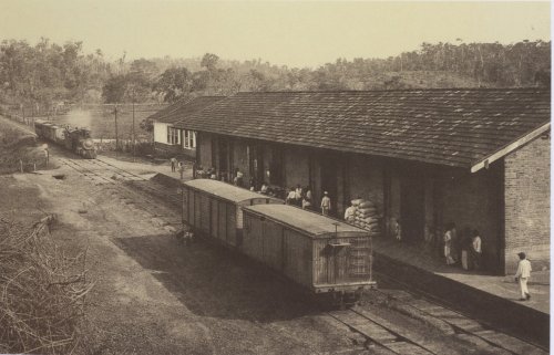
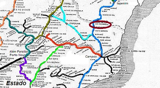
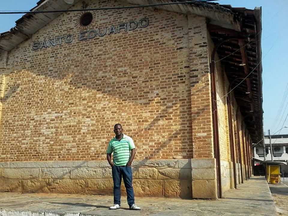
Itabapoana station was opened in June 1879 by the railway company E.F. Leopoldina (Coastal Line) and was located on the south bank of the Itabapoana in the Município de Campos, 350 km north-east of the capital Rio de Janeiro. In March 1893, a memorable name swap took place between this station and the Santo Eduardo station on the north bank of the Itabapoana in the state of Espírito Santo. From 1975 until its closure in 1996, the line belonged to Rede Ferroviária Federal S.A. (estacoesferroviarias.com.br). Today, the tracks still exist and the station building is a listed building.
In 1915 (photo from As Ferrovias do Brasil, by Cornejo and Gerodetti, on estacoesferroviarias.com.br)In August 2016 (photo: Marcos Augusto, on estacoesferroviarias.com.br)
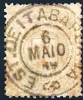
As Paulo Novaes writes on agenciaspostais.com.br, there had been a post office at the station since September 1879, which was called Santo Eduardo from March 1893. The oldest postmark to date is ERJ-0661a (illustration by Constantino Papazoglu):
ERJ-0661a (CP) 1881-1887
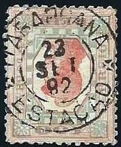
This was followed by ERJ-0661b (fig. agenciaspostais.com.br):
ERJ-0661b (PN) 1888-1890
This was followed by ERJ-0661c (Fig. agenciaspostais.com.br):
ERJ-0661c (PN) 1891-1892
R. Koester also showed the postmark with the imperial seal ERJ-0661d in Carimbologia XXIII:
ERJ-0661d (RK)E.F. Leopoldina
Andere Namen: Estação Santo Eduardo (1893)
Der Bahnhof Itabapoana wurde im Juni 1879 von der Eisenbahngesellschaft E.F. Leopoldina (Küstenlinie) eröffnet und lag am Südufer des Itabapoana im Município de Campos, 350 km nordöstlich der Hauptstadt Rio de Janeiro. Im März 1893 fand ein denkwürdiger Namenstausch zwischen diesem Bahnhof und dem Bahnhof Santo Eduardo am Nordufer des Itabapoana im Bundesstaat Espírito Santo statt. Von 1975 bis zu ihrer Stilllegung 1996 gehörte die Strecke der Rede Ferroviária Federal S.A. (estacoesferroviarias.com.br). Heute sind die Gleise noch vorhanden, das Bahnhofsgebäude steht unter Denkmalschutz.
Im Jahr 1915 (Foto aus As Ferrovias do Brasil, von Cornejo und Gerodetti, auf estacoesferroviarias.com.br)Im August 2016 (Foto: Marcos Augusto, auf estacoesferroviarias.com.br)
Wie Paulo Novaes auf agenciaspostais.com.br schreibt, gab es am Bahnhof seit September 1879 ein Postamt, das ab März 1893 auch Santo Eduardo hieß. Der bisher älteste Poststempel ist ERJ-0661a (Abb. Constantino Papazoglu):
ERJ-0661a (CP) 1881-1887
Es folgte ERJ-0661b (Abb. agenciaspostais.com.br):
ERJ-0661b (PN) 1888-1890
Danach kam ERJ-0661c (Abb. agenciaspostais.com.br):
ERJ-0661c (PN) 1891-1892
R. Koester zeigte auch in Carimbologia XXIII den Poststempel mit dem kaiserlichen Siegel ERJ-0661d:
Villiers de l’Ile Adam: Carta (…) das Provincias de Pernambuco, Alagoas e Sergipe, 1848
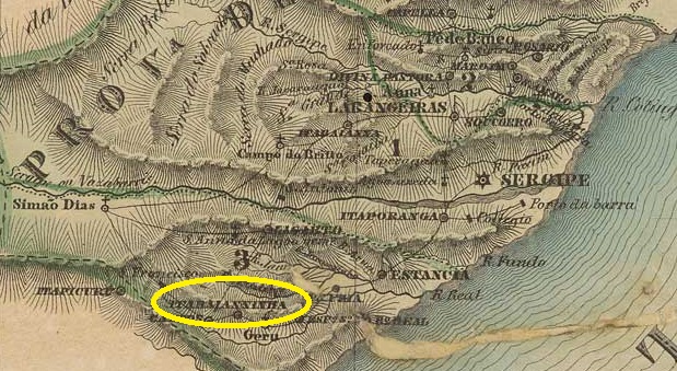
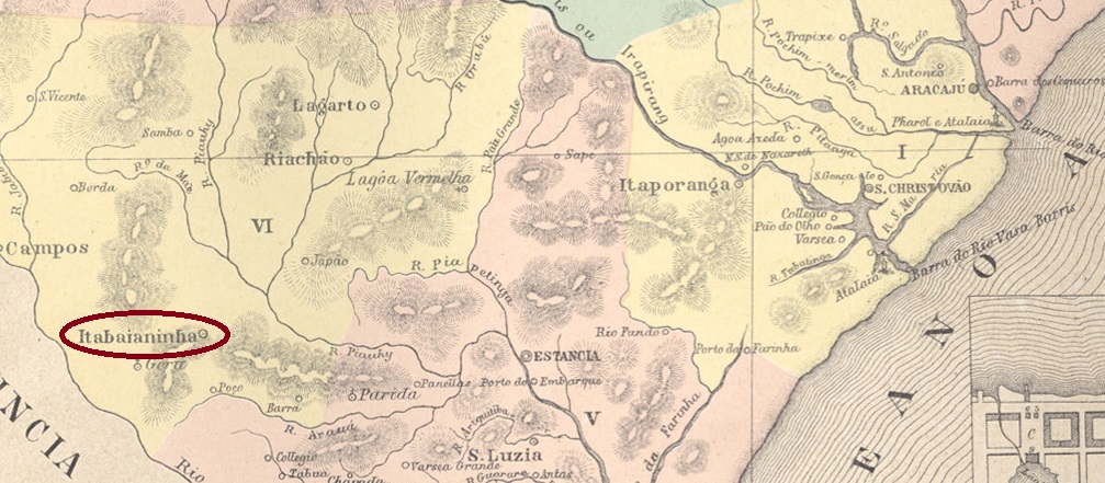
This old settlement was located 120 kilometres southwest of the later provincial capital of Aracaju and belonged to the Vila de Tomar de Geru. In February 1835 it became the Freguesia de N. Sra. da Conceição de Itabaianninha and in the same month the Vila, which has been the town of Itabainaninha (as it is spelt today) since September 1891.
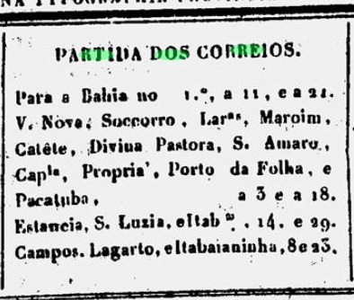
We have not yet been able to find out how long there has been a post office there, but the regional press reported that there was already a postal line to Itabaianinha in February 1840:
Correio Sergipense, 29/02/1840
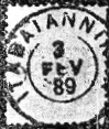
The only imperial postmark so far is ISE-0090b (fig. R. Koester, in Carimbologia XXIII):
ISE-0090b (RK) 1882-1889Atlas do Imperio do Brasil, 1868
Diese alte Siedlung lag 120 km südwestlich der späteren Provinzhauptstadt Aracaju und gehörte zur Vila de Tomar de Geru. Im Februar 1835 wurde sie zur Freguesia de N. Sra. da Conceição de Itabaianninha und noch im selben Monat zur Vila, die seit September 1891 die Stadt Itabainaninha (wie es heute geschrieben wird) ist.
Seit wann es dort ein Postamt gibt, konnten wir bisher nicht herausfinden, aber die regionale Presse berichtete, dass es bereits im Februar 1840 eine Postlinie nach Itabaianinha gab:
Correio Sergipense, 29.02.1840
Der bisher einzige kaiserliche Poststempel ist ISE-0090b (Abb. R. Koester, in Carimbologia XXIII):
Other names: Arraial de Sto. Antonio, Caatinga de Alves da Rocha
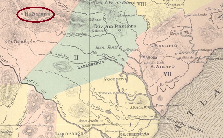
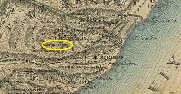
This place is said to have become a Vila as early as 1665 and only in October 1675 the Freguesia de Sto. Antonio e Almas de Itabaianna, 545 km north-west of the later provincial capital Aracaju. Itabaiana (as it is spelt today) has been a town since August 1888.
Two foundation dates were found for the local post office. Once in March 1829, as Nova Monteiro writes in Administrações e Agencias Postaes do Brasil Imperio (Brasil Filatelico/RJ, 1934-5; reprint SPP 1994-1999). Then again in May 1849, as R. Koester states in Carimbologia XXIII. The only postmark from the imperial period so far is ISE-0085b (fig. Roberto Assef Jr.):
ISE-0085b (RA) 1879-1892Villiers de l’Ile Adam: Carta (…) das Provincias de Pernambuco, Alagoas e Sergipe, 1848
Andere Namen: Arraial de Sto. Antonio, Caatinga de Alves da Rocha
Dieser Ort soll bereits 1665 zur Vila und erst im Oktober 1675 zur Freguesia de Sto. Antonio e Almas de Itabaianna, 545 km nordwestlich der späteren Provinzhauptstadt Aracaju. Seit August 1888 ist Itabaiana (wie es heute geschrieben wird) eine Stadt.
Für das örtliche Postamt wurden zwei Gründungsdaten gefunden. Einmal im März 1829, wie Nova Monteiro in Administrações e Agencias Postaes do Brasil Imperio (Brasil Filatelico/RJ, 1934-5; Nachdruck SPP 1994-1999) schreibt. Dann wieder im Mai 1849, wie R. Koester in Carimbologia XXIII angibt. Der bisher einzige Poststempel aus der Kaiserzeit ist ISE-0085b (Abb. Roberto Assef Jr.):
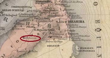
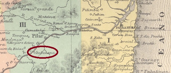
Villiers de l’Ile Adam: Carta (…) das Provincias do Rio Grande do Norte e Parahyba, 1848
Other names: Tabaiana
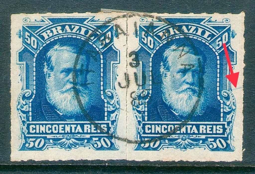
The village originated with the foundation of the parish of N. Sra. do Pilar around 1750 and then belonged to the Vila de Pilar (founded in September 1758), being located on the south bank of the Paraíba do Norte, 70 km south-west of the later provincial capital of Parahyba (today: João Pessoa). Itabaiana was elevated to Vila de Itabaiana do Pilar in October 1881, but four years later it became a freguesia of the re-established Vila do Pilar. In April 1890, Itabaiana once again became an independent Vila, which was elevated to the status of a town in March 1891. In December 1943, the município was renamed Tabaiana, but in September 1948 the old place name returned for good.
There also seems to have been a confusion in the postal system between the neighbouring towns of Itabaiana and Pilar, as Nova Monteiro writes in Administrações e Agencias Postaes do Brasil Imperio (Brasil Filatelico/RJ, 1934-5; reprint SPP 1994-1999) that there had been a post office in Pilar since May 1829. In the postal report (Relatorio dos Correios) for the year 1886, however, this date is attributed to the foundation of the post office in Itabaiana. As long as there are no old postmarks from Itabaiana, this question remains unanswered. The oldest postmark to date, IPB-0280c (image from the Internet), already bears a date of the Republic:
IPB-0280c (EB) 1897ffAtlas do Imperio do Brasil, 1868
Andere Namen: Tabaiana
Der Ort entstand mit der Gründung der Pfarrei N. Sra. do Pilar um 1750 und gehörte danach zur im September 1758 gegründeten Vila de Pilar, am Südufer des Paraíba do Norte, 70 km südwestlich der späteren Provinzhauptstadt Parahyba (heute: João Pessoa). Im Oktober 1881 erfolgte die Erhebung zur Vila de Itabaiana do Pilar, die doch vier Jahre später zur Freguesia der wieder etablierten Vila do Pilar wurde. Im April 1890 wurde Itabaiana wieder eine eigenständige Vila, die im März 1891 zur Stadt erhoben wurde. Im Dezember 1943 wurde das Município in Tabaiana umbenannt, aber im September 1948 kehrte der alte Ortsname endgültig zurück.
Auch im Postwesen scheint eine Verwechslung zwischen den Nachbarorten Itabaiana und Pilar vorzuliegen, denn Nova Monteiro schreibt in Administrações e Agencias Postaes do Brasil Imperio (Brasil Filatelico/RJ, 1934-5; Reprint SPP 1994-1999), dass es in Pilar seit Mai 1829 ein Postamt gab. Im Postbericht (Relatorio dos Correios) für das Jahr 1886 wird dieses Datum jedoch der Gründung des Postamtes in Itabaiana zugeschrieben. Solange es keine alten Poststempel aus Itabaiana gibt, bleibt die Frage unbeantwortet. Der bisher älteste Poststempel IPB-0280c (Abbildung aus dem Internet) trägt bereits ein Datum der Republik: