Categories
Carimbologia S

São Sebastião das Torres, Minas Gerais (SMG-2615)

Provincia de Minas Geraes, 1873

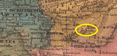
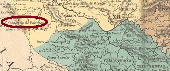
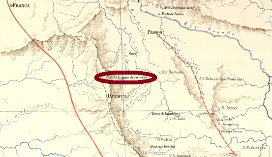
Other names: São Sebastião, Torres, Correia de Almeida (1943).

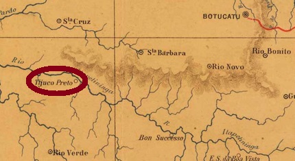
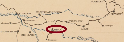
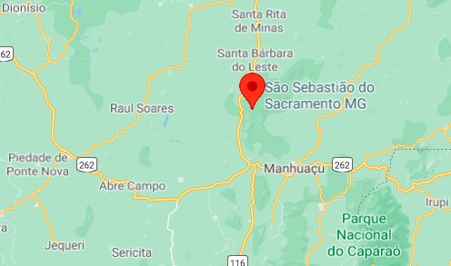
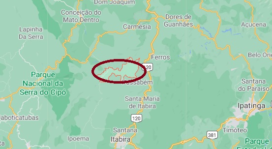
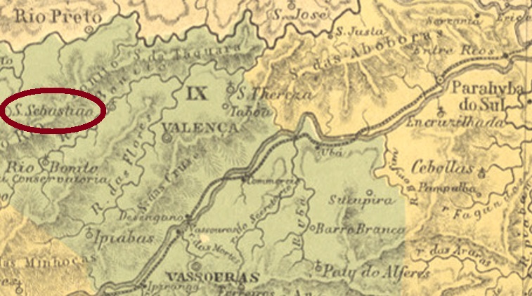
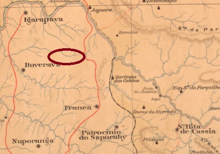
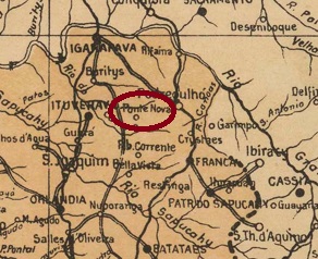
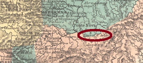
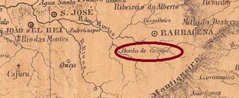
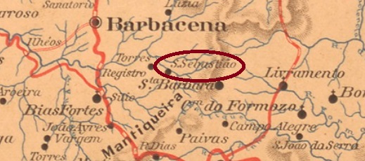
São Sebastião das Torres is said to have been a freguesia as early as August 1726, belonging to Borda do Campolide (today: Barbacena) and located a good 140 km south of the later provincial capital of Ouro Preto. It was not until October 1881 that the village was promoted to the district with the name São Sebastião – the addition “das Torres” (of the towers) was added a year later. In December 1938, the place name was shortened to Torres and five years later changed to the present Correia de Almeida. The name celebrates Joaquim Correia de Almeida (1820-1905) a priest born in Barbacena who became known as a poet and satirist.

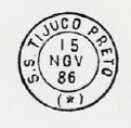
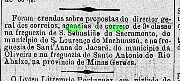
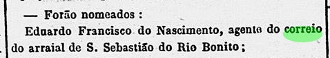
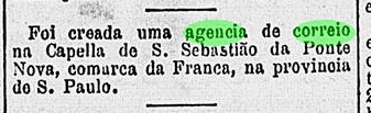
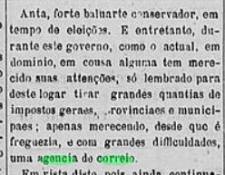
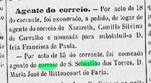
The local post office was established in January 1887, as Paula Sobrinho writes in História Postal de Minas Gerais (Belo Horizonte, 1997). A woman was the first postal agent, as reported by the provincial press:

A União, 26 January 1887

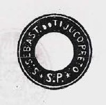
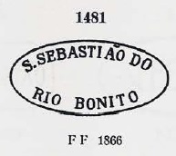
No imperial-era postmark has been seen so far.

Estado de Minas Geraes, 1910

Andere Namen: São Sebastião, Torres, Correia de Almeida (1943)

São Sebastião das Torres soll bereits ab August 1726 eine Freguesia gewesen sein, die zu Borda do Campolide (heute: Barbacena) gehörte und gut 140 km südlich der späteren Provinzhauptstadt Ouro Preto entfernt lag. Erst im Oktober 1881 stieg der Ort zum Distrikt mit Namen São Sebastião auf – der Zusatz „das Torres“ (der Türme) kam ein Jahr später dazu. Im Dezember 1938 wurde der Ortsname zu Torres gekürzt und wechselte fünf Jahre später zum heutigen Correia de Almeida. Der Name erinnert an Joaquim Correia de Almeida (1820-1905) einen in Barbacena geborenen Priester, der als Dichter und Satiriker bekannt wurde.

Das örtliche Postamt wurde im Januar 1887 ins Leben gerufen, wie Paula Sobrinho in História Postal de Minas Gerais (Belo Horizonte, 1997) schreibt. Eine Frau war die erste Postangestellte, wie die Regionalpresse berichtet:

A União, 26. Januar 1887

Bisher wurde kein Poststempel der Kaiserzeit gesehen.

Categories
Carimbologia S

São Sebastião do Tijuco Preto, São Paulo (SSP-1695)

J. M. Ribeiro Lisboa: Provincia de São Paulo, 1884

Other names:Tijuco Preto, Piraju (1891)

São Sebastião do Tijuco Preto was already around 1865a chapel near Botucatu, located on the south bank of the Paranapanema River, 320 km west of the provincial capital São Paulo. In March 1871, the place went as a district to the Município of S. João Baptista do Rio Verde before it became the Villa of S. Sebastião do Tijuco Preto in April 1880. The name was changed to Piraju in June 1891; this means Yellow Fish on Tupi-Guarani. Piraju has been a town since December 1906.

The local post office was established in December 1876, according to the regional press:

Correio Paulistano, 5 January 1877

Two postmarks of the imperial period were found, both already made known by Paulo Ayres in Catálogo de Carimbos Brasil-Império (S. Paulo, 1937, 1942). SSP-1695a was probably in use from the beginning until at least 1890:

SSP-1695a (P. A. p. 144)

Its successor SSP-1695b is a French type that was in circulation from 1886.

SSP-1695b (P. A. p.118) 1886-1890
Cia. Paulista

Andere Namen: Tijuco Preto, Piraju (1891)

São Sebastião do Tijuco Preto war bereits um 1865 eine Kapelle bei Botucatu, die am Südufer des Flusses Paranapanema lag,320 km westlich der Provinzhauptstadt São Paulo. Im März 1871 ging der Ort als Distrikt zum Município von S. João Baptista do Rio Verde, bevor daraus im April 1880 die Villa von S. Sebastião do Tijuco Preto wurde. Der Name wurde im Juni 1891 zu Piraju geändert; das bedeutet Gelber Fisch auf Tupi-Guarani. Seit Dezember 1906 ist Piraju eine Stadt.

Das Postamt vor Ort wurde im Dezember 1876 ins Leben gerufen, wie die Regionalpresse zu berichten weiß:

Correio Paulistano, 5. Januar 1877

Zwei Poststempel der Kaiserzeit wurden gefunden, beide sind bereits durch Paulo Ayres in Catálogo de Carimbos Brasil-Império(S. Paulo, 1937, 1942) bekannt gemacht. SSP-1695awar wohl von Beginn an bis mindestens 1890 in Gebrauch:

SSP-1695a (P. A. S. 144)

Sein Nachfolger SSP-1695b ist ein französischer -Typus, der ab 1886 im Umlauf war.

SSP-1695b (P. A. S. 118) 1886-1890

Categories
Carimbologia S

São Sebastião da Serra do Salitre, Minas Gerais (SMG-2605)

Atlas do Imperio do Brasil, 1868

Another name: Serra do Salitre (1938)

São Sebastião da Serra do Salitre (= in the Saltpetre Mountains) was a district of Patrocínio from September 1871, located almost 470 km northwest of the provincial capital Ouro Preto. In December 1938, the place name was shortened to Serra do Salitre, which became an independent município 15 years later.

Paula Sobrinho writes in his História Postal de Minas Gerais (Belo Horizonte, 1997) that there was a post office there from January 1883. The imperial postmark is SMG-2605a (Coll. by José A. Junges): a double circle with the inscription S. SEBASTIÃO DA SERRA DO SALITRE above and an ornament in lozenge below. The only copy seen so far is dated 1890 in the centre.

Estado de Minas Geraes, 1910

Anderer Name. Serra do Salitre (1938)

São Sebastião da Serra do Salitre (= im Salpetergebirge) war ab September 1871 ein Distrikt von Patrocínio, der knapp 470 km nordwestlich der Provinzhauptstadt Ouro Preto entfernt lag. Im Dezember 1938 wurde der Ortsname zu Serra do Salitre gekürzt, der 15 Jahre später zu einem eigenständigen Município wurde.

Paula Sobrinho schreibt in seiner História Postal de Minas Gerais (Belo Horizonte, 1997), dass es dort ab Januar 1883 ein Postamt gab. Der kaiserliche Poststempel ist SMG-2605a (Samml. José A. Junges): ein Doppelkreis mit der Inschrift S. SEBASTIÃO DA SERRA DO SALITRE oben und einem Ornament in Raute unten. Das bisher einzige Exemplar ist 1890 in der Mitte datiert.

Categories
Carimbologia S

São Sebastião do Sacramento,  Minas Gerais (SMG-2655

Estado de Minas Geraes, 1910

Another name: Sacramento

São Sebastião do Sacramento became a district of Manhuassu (now spelled Manhuaçú) in October 1878, which was situated more than 210 km east of the provincial capital of Ouro Preto, and this status has remained until today.

As Paula Sobrinho writes in História Postal de Minas Gerais (Belo Horizonte, 1997), there has been a post office there since January 1883. This is confirmed by the Rio press:

O Globo/RJ, 19.01.1883

The imperial postmark is SMG-2655a (Coll. José A. Junges): a double circle with the inscription S. SEBASTIÃO DO SACRAMENTO above and an ornament in lozenge below, the four sides of which are open. Dates in the centre from 1887 to 1909.

Google Maps

Anderer Name: Sacramento

São Sebastião do Sacramento wurde im Oktober 1878 ein Distrikt von Manhuassu (heute Manhuaçú geschrieben), der über 210 km östlich der Provinzhauptstadt Ouro Preto entfernt lag, und dieser Status ist bis heute erhalten geblieben.

Wie Paula Sobrinho in História Postal de Minas Gerais (Belo Horizonte, 1997) schreibt, gibt es dort ein Postamt seit Januar 1883. Das wird durch die Presse aus Rio bestätigt:

O Globo/RJ, 19.01.1883

Der kaiserliche Poststempel ist SMG-2655a (Samml. José A. Junges): ein Doppelkreis mit der Inschrift S. SEBASTIÃO DO SACRAMENTO oben und einem Ornament in Raute unten, dessen vier Seiten offen sind. Daten in der Mitte von 1887 bis 1909.

Categories
Carimbologia S

São Sebastião do Rio Preto, Minas Gerais (SMG-2650)

Estado de Minas Geraes, 1910

Another name: São Sebastião do Cemitério

In Minas Gerais there are at least three rivers called Rio Preto (=black). The best known of these is probably the one in the south, on the border with Rio de Janeiro. Its namesake in the north is near Diamantina and is a tributary of the Arassuahy (now spelled Araçuaí). And the third one in the group is today’s Rio Preto do Itambé, a tributary of the Rio Santo Antonio, where the settlement of São Sebastião do Cemitério originated. The name indicates what the village was known for. It is therefore not surprising that the parish established in June 1876 in the municipality of Conceição do Serro was given the name São Sebastião do Rio Preto. It was located on the south bank of the river, more than 210 km north of the provincial capital, Ouro Preto. The place has been a município since December 1962.

Two years of creation for the local post office were registered. Paula Sobrinho, in História Postal de Minas Gerais (Belo Horizonte, 1997), writes September 1873. This could be a typing error, as a post office establishment three years before parish status seems implausible. More likely is the second date exactly ten years later, as reported by the press from Juiz de Fora:

Pharol, 29.09.1883

Two 19th century postmarks were found. SMG-2650a (Coll. José A. Junges) is a double circle with the inscription S. SEBASTIÃO DO RIO PRETO on top and a four-leaf ornament in X below. Dates in the centre: 1889 to 1893. SMG-2650b (image from the internet) has the same inscription at the top, now an ornament in cross at the bottom, the dates in the centre go from 1899 to 1912.

Google Maps

Anderer Name: São Sebastião do Cemitério

In Minas Gerais gibt es mindestens drei Flüsse, die Rio Preto (schwarz) heißen. Der bekannteste davon dürfte der im Süden sein, an der Grenze zu Rio de Janeiro. Sein Namensvetter im Norden liegt bei Diamantina und ist ein Nebenfluss des Arassuahy (heute Araçuaí geschrieben). Und der dritte im Bunde ist der heutige Rio Preto do Itambé, ein Zufluss des Rio Santo Antonio, wo die Siedlung von São Sebastião do Cemitério entstand. Der Name (=Friedhof) besagt schon, wofür die Ortschaft bekannt war. Darum wundert es nicht, dass die im Juni 1876 errichtete Pfarrei in der Gemeinde Conceição do Serro den Namen São Sebastião do Rio Preto verpasst bekam. Die Pfarrei lag am Südufer des Flusses, über 210 km nördlich der Provinzhauptstadt Ouro Preto entfernt. Seit Dezember 1962 ist der Ort ein Município.

Zwei Entstehungsjahre fürs örtliche Postamt wurden registriert. Paula Sobrinho schreibt in História Postal de Minas Gerais (Belo Horizonte, 1997) den September 1873. Dies könnte ein Tippfehler sein, da eine Postamteinrichtung drei Jahre vor dem Pfarreistatus wenig plausibel erscheint. Wahrscheinlicher ist das zweite Datum genau zehn Jahre später, wie in der Presse aus Juiz de Fora bekanntgegeben:

Pharol, 29.09.1883

Zwei Poststempel aus dem 19. Jahrhundert wurden gefunden. SMG-2650a (Samml. José A. Junges) ist ein Doppelkreis mit der Inschrift S. SEBASTIÃO DO RIO PRETO oben und einem vierblättrigen Ornament in X unten. Daten in der Mitte: 1889 bis 1893. SMG-2650b (Abb. aus dem Internet) hat die gleiche Inschrift oben, unten ist nun ein Ornament in Kreuz, die Daten in der Mitte gehen von 1899 bis 1912.

Categories
Carimbologia S

São Sebastião do Rio Bonito, Rio de Janeiro (SRJ-1500)

Atlas do Imperio do Brasil, 1868

Another name: Pentagna (1938)

São Sebastião do Rio Bonito was a freguesia of Valença, located about 170 km northwest of the capital Rio de Janeiro. In November 1885, the place became a district, which has been called Pentagna since December 1938. The name recalls a former mayor, Humberto Pentagna.

Paulo Novaes (agenciaspostais.com.br) writes that the local post office was created in June 1861. In the Rio press, the first postal agent was presented in the same month:

Correio Mercantil, 27 June 1861

Four 19th century postmarks were found. The oldest one is SRJ-1500a, which also exists in blue and was already presented by Paulo Ayres in Catálogo de Carimbos Brasil-Império, (S. Paulo, 1937, 1942) under No. 1481:

SRJ-1500a (P.A. 1481) ca.1861- 1866ff

Three postmarks in double circle followed. SRJ-1500b (Coll. José A. Junges) has the inscription S.S. DO RIO BONITO at the top and dates inside from ca. 1876 to 1879. Its successors may be train station postmarks, since a station of the railway company Estrada de Ferro do Rio Bonito was inaugurated there in April 1880 (estacoesferroviarias.com.br).

In 1928 (Photo: Max Vasconcellos)

However, there is no corresponding reference in any postmark. SRJ-1500c (Coll. José A. Junges) has its outer circle doubled and the inscription S. SEB. DO RIO BONITO on the top; below is an ornament in lozenge formed by four small lozenges. Dates in the centre: 1883ff to 1889. SRJ-1500d (Coll. José A. Junges) could already be Republican because the only specimen bears a date from 1892 in the centre. Here the inscription at the top reads S. SEBAST. DO R. BONITO; below there is a Maltese cross.

Almanak Laemmert, 1892

Anderer Name: Pentagna (1938)

São Sebastião do Rio Bonito war eine Freguesia von Valença, die ca. 170 km nordwestlich der Hauptstadt Rio de Janeiro entfernt lag. Im November 1885 wurde der Ort zum Distrikt, der seit Dezember 1938 Pentagna heißt. Der Name erinnert an den ehemaligen Bürgermeister Humberto Pentagna.

Paulo Novaes (agenciaspostais.com.br) schreibt, dass das örtliche Postamt im Juni 1861 entstanden ist. In der Presse aus Rio wurde im gleichen Monat der erste Postagent vorgestellt:

Correio Mercantil, 27.06.1861

Vier Poststempel des 19. Jahrhunderts wurden gefunden. Der älteste ist SRJ-1500a, den es auch in blau gibt und der bereits durch Paulo Ayres in Catálogo de Carimbos Brasil-Império, (S. Paulo, 1937, 1942) unter Nr. 1481 vorgestellt wurde:

SRJ-1500a (P.A. 1481) ca.1861- 1866ff

Es folgten drei Poststempel in Doppelkreis. SRJ-1500b (Samml. José A. Junges) hat oben die Inschrift S.S. DO RIO BONITO und Daten im Inneren von ca. 1876 bis 1879. Seine Nachfolger dürfen Bahnhofsstempel sein, da im April 1880 ein Bahnhof der Bahngesellschaft Estrada de Ferro do Rio Bonito dort eingeweiht wurde (estacoesferroviarias.com.br).

1928 (Foto: Max Vasconcellos)

Allerdings ist auf keinem Stempel ein entsprechender Hinweis zu lesen. SRJ-1500c (Samml. José A. Junges) hat den äußeren Stempelkreis verdoppelt und oben die Inschrift S. SEB. DO RIO BONITO; unten ist ein Ornament in Raute, das aus vier kleinen Rauten gebildet wird. Daten in der Mitte: 1883ff bis 1889. SRJ-1500d (Samml. José A. Junges) könnte bereits republikanisch sein, denn das einzige Exemplar trägt ein Datum aus 1892 in der Mitte. Hier lautet die Inschrift oben S. SEBAST. DO R. BONITO; unten ist ein Malteser Kreuz zu sehen.

Categories
Carimbologia S

São Sebastião de Pouso Alegre, Minas Gerais (SMG-2247)

Atlas do Imperio do Brasil, 1868

Other names: São Sebastião da Confusão, São Gothardo

See also São Gothardo (SMG-2340)

São Sebastião de Pouso Alegre was the second name of this settlement in the Minas Gerais province, located near Pitangui, about 400 km west of the capital Ouro Preto. In the beginning, the village was called São Sebastião da Confusão (= of the Confusion). Such a name was apparently too bizarre for the authorities, so in May 1852 the place was officially renamed to São Sebastião de Pouso Alegre, although the old name remained in use. In July 1868, the town changed to the new municipality of Dores do Indayá, and it was not until August 1885 that it was called São Gothardo. After that, it changed the municipality twice: in November 1890 to Carmo do Paranahyba, and in August 1911 to Rio Paranahyba. Since September 1914, São Gotardo has been an independent municipality.

According to Paula Sobrinho (História Postal de Minas Gerais, Belo Horizonte, 1997), there has been a post office there since November 1883. The imperial postmark is SMG-2247a (Coll. Márcio Protzner): a double circle with the inscription S. SEBASTIĀO DE POUSO ALEGRE above and a five-leg star below, plus the dates 1887 to 1896 in the centre. Therefore, probably all cancels featuring São Gothardo are republican.

Provincia de Minas Geraes, 1873

Andere Namen: São Sebastião da Confusão, São Gothardo

Siehe auch São Gothardo (SMG-2340)

São Sebastião de Pouso Alegre war der zweite Name dieser Siedlung in der Provinz Minas Gerais, die in der Nähe von Pitangui lag, etwa 400 km westlich der Hauptstadt Ouro Preto entfernt. Am Anfang hieß das Dorf São Sebastião da Confusão (=der Verwirrung). Solcher Name war der Obrigkeit offenbar zu bunt, also wurde der Ort im Mai 1852 offiziell zu São Sebastião de Pouso Alegre umbenannt, obwohl der alte Name weiterhin in Gebrauch blieb. Im Juli 1868 wechselte der Ort zum neuen Municipio von Dores do Indayá, und erst im August 1885 hieß er dann São Gothardo. Er wechselte noch zweimal seine Zuständigkeit: im November 1890 zu Carmo do Paranahyba, und im August 1911 zu Rio Paranahyba. Seit September 1914 ist São Gotardo ein eigenständiger Município.

Laut Paula Sobrinho (História Postal de Minas Gerais, Belo Horizonte, 1997) gibt es dort ein Postamt seit November 1883. Der kaiserliche Poststempel ist SMG-2247a (Samml. Márcio Protzner): ein Doppelkreis mit der Inschrift S. SEBASTIĀO DE POUSO ALEGRE oben und einem fünfzackigen Stern unten, dazu die Jahreszahlen 1887 bis 1896 in der Mitte. Also ist es wahrscheinlich, dass alle Stempel mit São Gothardo republikanisch sind.

Categories
Carimbologia S

São Sebastião da Ponte Nova, São Paulo (SSP-1235)

Mappa de Minas Geraes, 1910

Another name: Jeriquara (1926)

São Sebastião da Ponte Nova (= of the New Bridge) was a freguesia of Franca from March 1885, located close to the south bank of the Ponte Nova River, barely 440 km north of the provincial capital São Paulo. It was not until October 1919 that the place rose to district, which was renamed Jeriquara seven years later. The Indian word means “parrot hideout”. Jeriquara has been an independent município since February 1964.

The local post office was created in November 1883, according to the Rio Press:

Gazeta de Noticias/RJ, 24/11/1883

However, as the agency was not listed in the Imperial Mail Register (Tabella das Agencias do Correio do Imperio) of 1885, it probably started operations later. The oldest postmark so far is SSP-1235a (Coll. José A. Junges): a double circle with the inscription S.S. DA PONTE NOVA at the top. The only specimen is dated 1891 in the centre and unfortunately does not show the lower part completely.

Arthur D. Ribeiro: Estado de São Paulo, 1924

Anderer Name: Jeriquara (1926)

São Sebastião da Ponte Nova (=der Neuen Brücke) war ab März 1885 eine Freguesia von Franca, die nah am Südufer des Flusses Ponte Nova lag, knapp 440 km nördlich der Provinzhauptstadt São Paulo entfernt. Erst im Oktober 1919 stieg der Ort zum Distrikt auf, der sieben Jahre später zu Jeriquara umbenannt wurde. Das indianische Wort bedeutet „Papagaienversteck“. Seit Februar 1964 ist Jeriquara ein eigenständiger Município.

Das örtliche Postamt wurde im November 1883 ins Leben gerufen, wie aus der Rio Presse hervorgeht:

Gazeta de Noticias/RJ, 24.11.1883

Da allerdings die Agentur nicht im Verzeichnis der kaiserlichen Postämter (Tabella das Agencias do Correio do Imperio) von 1885 aufgelistet wurde, hat sie wohl erst später den Betrieb aufgenommen. Der bisher älteste Poststempel ist SSP-1235a (Samml. José A. Junges): ein Doppelkreis mit der Inschrift S.S. DA PONTE NOVA oben. Das einzige Exemplar ist 1891 in der Mitte datiert und zeigt den unteren Teil leider nicht vollständig.

Categories
Carimbologia S

São Sebastião da Pedra do Anta, Minas Gerais (SMG-2600)

Atlas do Imperio do Brasil, 1868

See also Pedra do Anta (R. Koester: Carimbologia XXXI).

São Sebastião da Pedra do Anta, also called Pedra do Anta, or simply Anta (Tapir), was a district of Santa Rita do Turvo (now Viçosa) from October 1848, located close to the west bank of the Casca River, a good 130 km east of the provincial capital Ouro Preto. In September 1923, the place name was officially simplified to Pedra do Anta, and the district became part of the newly created Município of Teixeiras in December 1938, before political emancipation took place in December 1962.

Two creation dates for the local post office have been found, and since there are also newspaper reports of local postal traffic between both dates, we can assume that the agency was closed in the meantime. Both Reinhold Koester and the Imperial Mail Register (Tabella das Agencias do Correio do Imperio, Rio de Janeiro, 1885) state that the post office was created in 1871, while Paula Sobrinho (História Postal de Minas Gerais, Belo Horizonte, 1997) gives the exact date of 25 August 1881 for it. A newspaper notice from Rio in October 1875 confirms the existence of the post office in Anta:

A Reforma/RJ, 17 October 1875

So far, no imperial postmark with the complete place name has been found. For postmarks with PEDRA DO ANTA see R. Koester: Carimbologia XXXI.

Villeers de l’Ile Adam: Carta (…) da Provincia de Minas Geraes, 1849

Siehe auch Pedra do Anta (R. Koester: Carimbologia XXXI)

São Sebastião da Pedra do Anta, auch Pedra do Anta, oder einfach Anta (Tapir) genannt, war ab Oktober 1848 ein Distrikt von Santa Rita do Turvo (heute: Viçosa), der nah am Westufer des Flusses Casca lag, gut 130 km östlich der Provinzhauptstadt Ouro Preto entfernt. Im September 1923 wurde der Ortsname offiziell zu Pedra do Anta vereinfacht, und der Distrikt ging im Dezember 1938 zum neu gegründeten Município von Teixeiras, bevor die politische Emanzipation im Dezember 1962 stattfand.

Zwei Gründungsdaten fürs örtliche Postamt wurden gefunden, und da auch Zeitungsberichte über lokalen Postverkehr zwischen beiden Angaben vorliegen, können wir davon ausgehen, dass die Agentur in der Zwischenzeit geschlossen wurde. Sowohl Reinhold Koester als auch das Verzeichnis der kaiserlichen Postämter (Tabella das Agencias do Correio do Imperio, Rio de Janeiro, 1885) schreiben, das Postamt entstand anno 1871, während Paula Sobrinho (História Postal de Minas Gerais, Belo Horizonte, 1997) dafür das genaue Datum 25. August 1881 angibt. Eine Zeitungsnachricht aus Rio vom Oktober 1875 bestätigt das Vorhandensein des Postamts in Anta:

A Reforma/RJ, 17. Oktober 1875

Bisher wurde kein kaiserlicher Poststempel mit dem vollständigen Ortsnamen gefunden. Für Stempel mit PEDRA DO ANTA siehe R. Koester: Carimbologia XXXI.

Categories
Carimbologia S

São Sebastião do Paraíso, Minas Gerais (SMG-2645)

Atlas do Imperio do Brasil, 1868

This St. Sebastian “from Paradise” was a freguesia of Jacuhy from May 1855, located on the provincial border with São Paulo, almost 500 km west of the capital Ouro Preto. In September 1870, the place rose to the status of a villa.

As Paula Sobrinho writes in História Postal de Minas Gerais (Belo Horizonte, 1997), the local post office came into being in May 1871. Three early postmarks in double circle were found. SMG-2645a (Coll. José A. Junges) has the inscription S.S. DO PARAISO at the top, and the dates inside go from 1877 to 1886. In SMG-2645b (Coll. José A. Junges) the inscription above now reads S. SEBASTIĀO DO PARAIZO, and at the bottom we see a diamond formed by four small diamonds, with dates inside from 1887 to 1890. In SMG-2645c (coll. Dieter Kerkhoff), the small tilde floats between A and O in the above inscription S. SEBASTIÃO DO PARAIZO. Below, the inscription reads (MINAS) and the inner dates are already Republican: 1890 to 1900.

E.F. Central do Brasil, 1890

Dieser Hl. Sebastian “aus dem Paradies” war ab Mai 1855 eine Freguesia von Jacuhy, die an der Provinzgrenze zu São Paulo lag, fast 500 km westlich der Hauptstadt Ouro Preto entfernt. Im September 1870 stieg der Ort zur Villa auf.

Wie Paula Sobrinho in História Postal de Minas Gerais (Belo Horizonte, 1997) schreibt, entstand das örtliche Postamt im Mai 1871. Drei frühe Poststempel in Doppelkreis wurden gefunden. SMG-2645a (Samml. José A. Junges) hat oben die Inschrift S.S. DO PARAISO, und die Daten im Inneren gehen von 1877 bis 1886. Im SMG-2645b (Samml. José A. Junges) lautet die obige Inschrift nun S. SEBASTIĀO DO PARAIZO, unten sehen wir eine Raute, die aus vier kleinen Rauten gebildet wird, mit Daten im Inneren von 1887 bis 1890. Bei SMG-2645c (Samml. Dieter Kerkhoff) schwebt die kleine Tilde zwischen A und O in der obigen Inschrift S. SEBASTIÃO DO PARAIZO. Unten lautet die Inschrift (MINAS) und die inneren Daten sind bereits republikanisch: 1890 bis 1900.