Categories
Carimbologia S

São Sebastião do Parahyba, Rio de Janeiro (SRJ-1490)

Atlas do Imperio do Brasil, 1868

Another name: Euclides da Cunha (1938-1943)

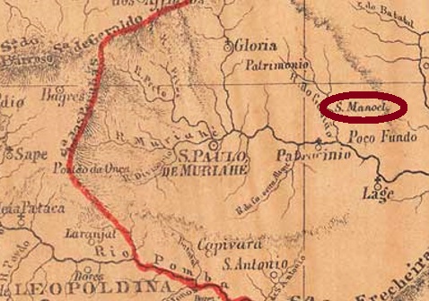
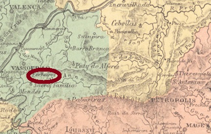
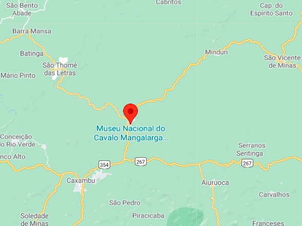
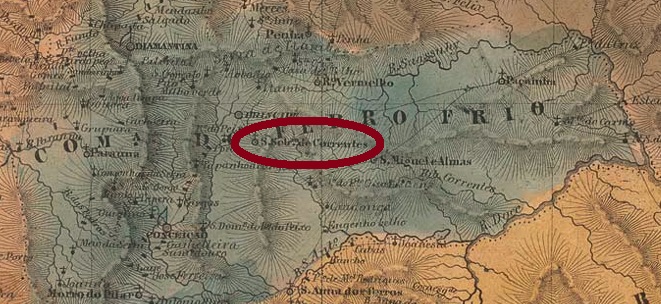
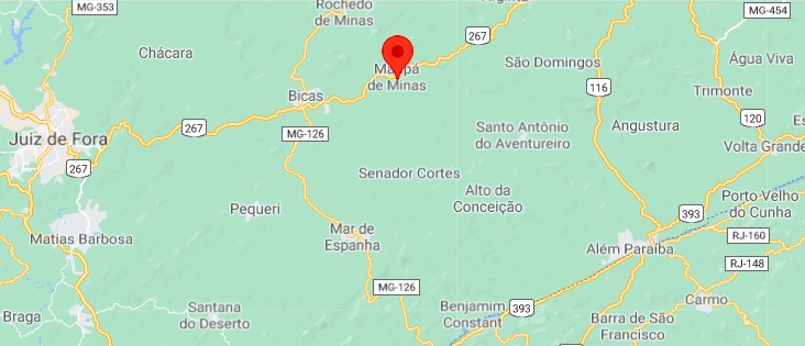
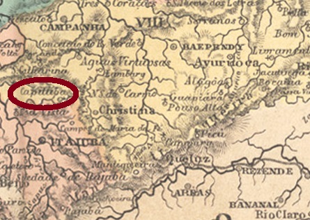
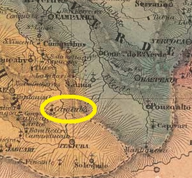
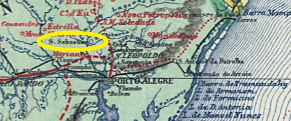
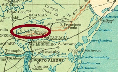
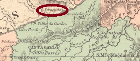
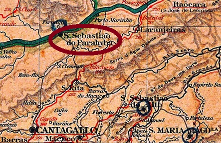
This locality was a district of Cantagallo from December 1874, located on the south bank of the Parahyba do Sul River, over 220 km northeast of the capital Rio de Janeiro. It rose to villa status around 1890, but soon reverted to district. Between 1938 and 1943, the village was called Euclides da Cunha, in memory of the famous engineer and writer (1866-1909) who was born in the area. After that, the old name returned for the district, and so it remains today.

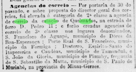
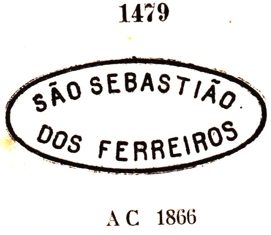
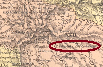
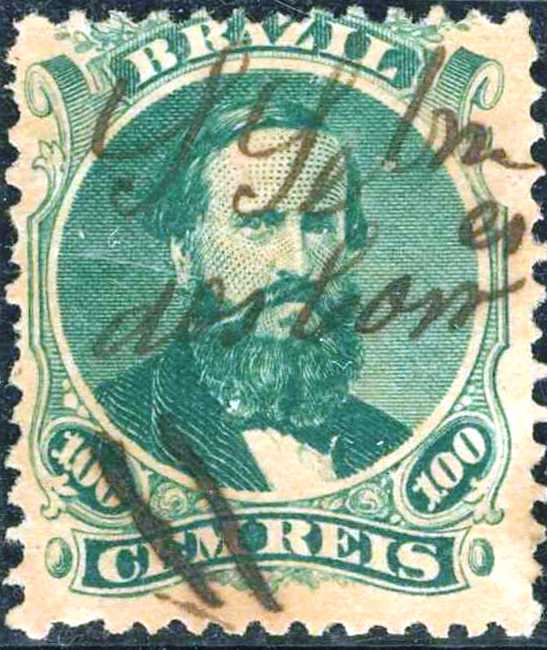
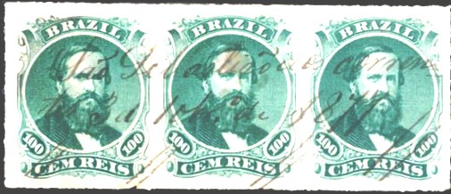
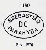
The Imperial Mail Register (Tabella das Agencias do Correio do Imperio, Rio de Janeiro, 1885) reports a post office there from 1871. Three postmarks of the imperial period were found. The oldest one, SRJ-1490a, was probably in use from the beginning and was presented by Paulo Ayres in Catálogo de Carimbos Brasil-Império (S. Paulo, 1937, 1942) under No. 1480:

SRJ-1490a (P.A. 1480) ca. 1871-1877ff

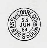
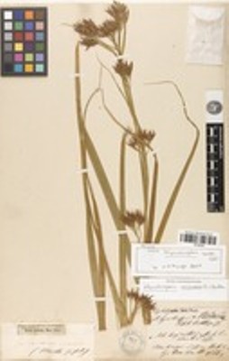
Two cancels in double circle followed. SRJ-1490b (agenciaspostais.com.br) was seen only once in reddish brown and has the inscription S.S. DO PARAHYBA at the top, with an inner date of 1883. Its successor SRJ-1490c (coll. Karlheinz Wittig) has the inscription S. SEBASTIĀO DO PARAHYBA at the top and an ornament in X at the bottom. Dates in the middle between 1888 and 1891.

Almanak Laemmert, 1892

Anderer Name: Euclides da Cunha (1938-1943)

Diese Ortschaft war ab Dezember 1874 ein Distrikt von Cantagallo, der am Südufer des Flusses Parahyba do Sul lag, gut 220 km nordöstlich der Hauptstadt Rio de Janeiro entfernt. Um ca. 1890 stieg er zur Villa auf, kehrte aber bald zum Distrikt-Status zurück. Zwischen 1938 und 1943 hieß der Ort Euclides da Cunha, in Erinnerung an den berühmten Ingenieur und Schriftsteller (1866-1909), der in der Gegend geboren wurde. Danach kehrte der alte Name des Distrikts zurück, und so ist es bis heute geblieben.

Im Verzeichnis der kaiserlichen Postämter (Tabella das Agencias do Correio do Imperio, Rio de Janeiro, 1885) liest man, dass es dort ab 1871 ein Postamt gab. Drei Poststempel der Kaiserzeit waren zu finden. Der älteste davon, SRJ-1490a, war wohl von Anfang an in Gebrauch und wurde bereits durch Paulo Ayres in Catálogo de Carimbos Brasil-Império (S. Paulo, 1937, 1942) unter Nr. 1480 vorgestellt:

SRJ-1490a (P.A. 1480) ca. 1871-1877ff

Es folgten zwei Stempel in Doppelkreis. SRJ-1490b (agenciaspostais.com.br) war bisher nur einmal in rotbraun zu sehen und hatte oben die Inschrift S.S. DO PARAHYBA, mit einem inneren Datum aus 1883. Sein Nachfolger SRJ-1490c (Samml. Karlheinz Wittig) hat oben die Inschrift S. SEBASTIĀO DO PARAHYBA und unten ein Ornament in X. Daten in der Mitte zwischen 1888 und 1891.

Categories
Carimbologia S

São Sebastião da Matta, Minas Gerais (SMG-2590)

Provincia de Minas Geraes, 1873

Other names: São Manoel, Eugenópolis (1943).

This São Sebastião “in the woods” (da Matta) was a district of São Paulo do Muriahé from December 1870, located on the Gavião (Hawk) River, about 240 km southeast of the provincial capital Ouro Preto. In March 1891, the village rose to a villa called São Manoel, which became a town in September 1925. Since December 1943, the Município is now called Eugenópolis, in memory of Luiz Eugenio Monteiro de Barros, a local landowner and politician who had worked for the political emancipation of the municipality.

The local post office was created in November 1881, as Paula Sobrinho writes in História Postal de Minas Gerais (Belo Horizonte, 1997). This is also reported by the press in Rio de Janeiro:

Jornal do Commercio/RJ, December 2, 1881

The imperial postmark is SMG-2590a (Coll. José A. Junges): a double circle, which also exists in blue, with the inscription S. SEBASTIĀO DA MATTA above and an ornament in lozenge below, the four sides of which are open. Dates in the centre from 1885 to 1891.

Estado de Minas Geraes, 1910

Andere Namen: São Manoel, Eugenópolis (1943)

Dieser São Sebastião „im Walde” (da Matta) war ab Dezember 1870 ein Distrikt von São Paulo do Muriahé, der am Fluss Gavião (Habicht) lag, rund 240 km südöstlich der Provinzhauptstadt Ouro Preto entfernt. Im März 1891 steigt der Ort zu einer Villa namens São Manoel, die im September 1925 zur Stadt aufstieg. Seit Dezember 1943 heißt der Município Eugenópolis, zur Erinnerung an Luiz Eugenio Monteiro de Barros, einem einheimischen Großgrundbesitzer und Politiker, der sich um die politische Emanzipation der Gemeinde verdient gemacht hatte.

Das örtliche Postamt entstand im November 1881, wie Paula Sobrinho in História Postal de Minas Gerais (Belo Horizonte, 1997) schreibt.

Jornal do Commercio/RJ, 2. Dezember 1881

Der kaiserliche Poststempel ist SMG-2590a (Samml. José A. Junges): ein Doppelkreis, den es auch in blau gibt, mit der Inschrift S. SEBASTIĀO DA MATTA oben und einem Ornament in Raute unten, deren vier Seiten offen sind. Daten in der Mitte von 1885 bis 1891.

Categories
Carimbologia S

São Sebastião do Jaguary, Minas Gerais (SMG-2640)

Estado de Minas Geraes, 1910

The series of towns in honour of St. Sebastian in Minas Gerais continues with this one on the north bank of the river Jaguary-Mirim (Little River of the Jaguars). Since October 1860, it was a district of Caldas, more than 520 km southwest of the provincial capital, Ouro Preto. In September 1888, it became the Villa of Caracol (Snail), which was elevated to a town in September 1925 and changed its name to Andradas three years later. The still current place name is said to commemorate the former governor of Minas Antonio Carlos Ribeiro de Andrada (1870-1946).

According to Paula Sobrinho (História Postal de Minas Gerais, Belo Horizonte, 1997), there has been a post office there since November 1876. The imperial postmark is SMG-2640a (Coll. José A. Junges): a double circle with the inscription S. SEBASTIĀO DO JAGUARY above and an ornament in cross below formed by four small diamonds. The previous dates inside are from the period 1886-1888ff.

Mappa Geral do Brasil, 1911

Andere Namen: Caracol, Andradas (1928)

Die Reihe der Ortschaften zu Ehren vom Hl. Sebastian in Minas Gerais wird mit dieser am Nordufer des Flusses Jaguary-Mirim (Kleiner Fluss der Jaguare) fortgesetzt. Seit Oktober 1860 war sie ein Distrikt von Caldas, der über 520 km südwestlich der Provinzhauptstadt Ouro Preto entfernt lag. Im September 1888 wurde daraus die Villa von Caracol (Schnecke), die im September 1925 zur Stadt erhoben wurde und den Namen drei Jahre später zu Andradas änderte. Der noch aktuelle Ortsname soll an den ehemaligen Gouverneur von Minas Antonio Carlos Ribeiro de Andrada (1870-1946) erinnern.

Laut Paula Sobrinho (História Postal de Minas Gerais, Belo Horizonte, 1997) gibt es dort ein Postamt seit November 1876. Der kaiserliche Poststempel ist SMG-2640a (Samml. José A. Junges): ein Doppelkreis mit der Inschrift S. SEBASTIĀO DO JAGUARY oben und ein Ornament in Kreuz unten, das aus vier kleinen Rauten gebildet wird. Die bisherigen Daten im Inneren entstammen dem Zeitraum 1886-1888ff.

Categories
Carimbologia S

São Sebastião dos Ferreiros, Rio de Janeiro (SRJ-1505)

Atlas do Imperio do Brasil, 1868

Another name: Ferreiros

There were two localities with this name in 19th century Brazil, but the São Sebastião dos Ferreiros of Minas Gerais province did not open its post office until 1892. Its counterpart from the province of Rio was already a district of Vassouras in 1858, about 120 km northwest of the capital Rio de Janeiro. It has remained so to this day, although between 1909 and 1938 the district was simply called Ferreiros.

As Paulo Novaes (agenciaspostais.com.br) writes, there was a post office there since September 1867. SRJ-1505a is the earliest postmark, already presented by Paulo Ayres in Catálogo de Carimbos Brasil-Império (S. Paulo, 1937, 1942) under No. 1479:

SRJ-1505a (P.Ayres 1479) ca. 1867-1876

It was followed by the double circle SRJ-1505b (Coll. Dieter Kerkhoff), with the above inscription S. S. DOS FERREIROS and an inner date of 1890. SRJ-1505c (Coll. Fuad Ferreira Fo.) might probably be already Republican: a double circle with the inscription S. SEBAST. DOS FERREIROS above and an ornament in cross below. Dates inside between 1899 and 1900.

agenciaspostais.com.br

Anderer Name: Ferreiros

Im Brasilien des 19. Jahrhunderts gab es zwei Ortschaften mit diesem Namen, aber der São Sebastião dos Ferreiros der Provinz Minas Gerais hat sein Postamt erst 1892 eröffnet. Sein Kollege aus der Provinz Rio war schon 1858 ein Distrikt von Vassouras, der ca. 120 km nordwestlich der Hauptstadt Rio de Janeiro entfernt lag. So ist es bis heute geblieben, wenngleich der Distrikt zwischen 1909 und 1938 lediglich Ferreiros hieß.

Wie Paulo Novaes (agenciaspostais.com.br) schreibt, gab es dort ein Postamt seit September 1867. SRJ-1505a ist der früheste Poststempel, der bereits durch Paulo Ayres in Catálogo de Carimbos Brasil-Império (S. Paulo, 1937, 1942) unter Nr. 1479 vorgestellt wurde:

SRJ-1505a (P.Ayres 1479) ca.1867-1876

Ihm folgte der Doppelkreis SRJ-1505b (Samml. Dieter Kerkhoff), mit der obigen Inschrift S. S. DOS FERREIROS und einem inneren Datum aus 1890. SRJ-1505c (Samml. Fuad Ferreira Fo.) wird wohl bereits republikanisch sein: ein Doppelkreis mit der Inschrift S. SEBAST. DOS FERREIROS oben und einem Ornament in Kreuz unten. Daten im Inneren zwischen 1899 und 1900.

Categories
Carimbologia S

São Sebastião da Encruzilhada, Minas Gerais (SMG-2585)

Estado de Minas Geraes, 1910

Other names: Encruzilhada (see also R. Koester: Carimbologia XVII), Cruzília (1948)

This locality was a freguesia of Baependy from November 1873, located on the Rio do Peixe, barely 300 km southwest of the provincial capital of Ouro Preto. Only in December 1938 did it rise to the status of a district – under the name Encruzilhada (=crossroads) – and another ten years later it became the Município of Cruzília.

As Paula Sobrinho writes in História Postal de Minas Gerais (Belo Horizonte, 1997), there has been a post office there since May 1876. So far, no imperial postmark with the complete place name has been found. For postmarks with ENCRUZILHADA see R. Koester: Carimbologia XVII.

Google Maps

Andere Namen: Encruzilhada (siehe auch R. Koester: Carimbologia XVII), Cruzília (1948)

Diese Ortschaft war ab November 1873 eine Freguesia von Baependy, die am Fluss Rio do Peixe lag, knapp 300 km südwestlich der Provinzhauptstadt Ouro Preto entfernt. Erst im Dezember 1938 stieg sie zum Distrikt auf – unter dem Namen Encruzilhada (=Wegkreuzung) – und weitere zehn Jahre später wurde daraus der Município von Cruzília.

Wie Paula Sobrinho in História Postal de Minas Gerais (Belo Horizonte, 1997) schreibt, gibt es dort ein Postamt seit Mai 1876. Bisher wurde kein kaiserlicher Poststempel mit dem vollständigen Ortsnamen gefunden. Für Stempel mit ENCRUZILHADA siehe R. Koester: Carimbologia XVII.

Categories
Carimbologia S

São Sebastião de Correntes, Minas Gerais (SMG-3630)

Atlas do Imperio do Brasil, 1868

Another name: Sabinópolis (1923)

São Sebastião de Correntes (of the Chains) was a parish in the Município of Rio Doce from April 1840, located over 310 km north of the provincial capital Ouro Preto. In September 1923, the place rose to become the villa of Sabinópolis in its own municipality, and two years later Sabinópolis was a town. The name is meant to celebrate Sabino Alves Barroso Júnior (1859-1919), a prominent son of the town who played an important role in Brazilian politics at the turn of the century as a lawyer, journalist and politician.

As Paula Sobrinho writes in História Postal de Minas Gerais (Belo Horizonte, 1997), there had been a post office there since October 1875. Possibly the postmark was not finished in time, as some handwritten cancellations were found on Dom Pedro issues from 1866 and 1877:

Marcio Protzner Collection
Alberto Torres

The earliest postmark so far is SMG-3630a (image from the internet): a double circle with the inscription S. SEBASTIĀO DE CORRENTES on top and an ornament in cross below, consisting of four small diamonds. Dates in the centre from 1886 to 1906.

Villiers de l’Ile Adam: Carta (…) da Provincia de Minas Geraes, 1849

Anderer Name: Sabinópolis (1923)

São Sebastião de Correntes (der Ketten) war ab April 1840 eine Pfarrei im Município von Rio Doce, die über 310 km nördlich der Provinzhauptstadt Ouro Preto entfernt lag. Im September 1923 stieg der Ort zur Villa von Sabinópolis im eigenen Município auf, und zwei Jahre später war Sabinópolis eine Stadt. Der Name soll an Sabino Alves Barroso Júnior (1859-1919) erinnern, einen prominenten Sohn des Orts, der als Jurist, Journalist und Politiker eine prägende Rolle in der brasilianischen Politik der Jahrhundertwende gespielt hat.

Wie Paula Sobrinho in História Postal de Minas Gerais (Belo Horizonte, 1997) schreibt, gab es dort ein Postamt seit Oktober 1875. Möglicherweise war der Poststempel nicht rechtzeitig fertig geworden, da einige handschriftliche Entwertungen auf Dom-Pedro-Ausgaben von 1866 und 1877 gefunden wurden:

Sammlung Marcio Protzner
Alberto Torres

Der bisher früheste Poststempel ist SMG-3630a (Abb. aus dem Internet): ein Doppelkreis mit der Inschrift S. SEBASTIĀO DE CORRENTES oben und einem Ornament in Kreuz unten, das aus vier kleinen Rauten besteht. Daten in der Mitte von 1886 bis 1906.

Categories
Carimbologia S

São Sebastião do Córrego do Meio, Minas Gerais (SMG-2625)

Mappa de Minas Geraes, 1910

Other names: Maripá, Maripá de Minas (1962).

This settlement was first called Córrego do Meio (Middle Stream) and was located close to the provincial border with Rio de Janeiro, a good 270 km south of the capital Ouro Preto. In April 1890, it became a district of Mar d’Hespanha, which changed to the newly founded Município of Guarará the following year. Since December 1962, the municipality has been independent, under the name Maripá de Minas. The name refers to Attalea maripa (Martius), a palm tree of the Arecaceae family:

Attalea maripa (Photo: Arria Belli, CC BY 2.5)

Paula Sobrinho writes in Historia Postal de Minas Gerais (Belo Horizonte, 1997) that there was a post office there from April 1881. The imperial postmark SMG-2625a has already been made known by Paulo Ayres in Catálogo de Carimbos Brasil-Império (S. Paulo, 1937, 1942):

SMG-2625a (P. Ayres p. 126) 1885-1890
Google Maps

Andere Namen: Maripá, Maripá de Minas (1962)

Diese Siedlung hieß zunächst Córrego do Meio (Mittlerer Bach) und lag nah an der Provinzgrenze zu Rio de Janeiro, gut 270 km südlich der Hauptstadt Ouro Preto entfernt. Im April 1890 wurde daraus ein Distrikt von Mar d’Hespanha, der im darauffolgenden Jahr zum neu gegründeten Município von Guarará wechselte. Seit Dezember 1962 ist die Gemeinde eigenständig, unter dem Namen Maripá de Minas. Der Name bezeichnet Attalea maripa (Martius), eine Palme der Familie Arecaceae:

Attalea maripa (Foto: Arria Belli, CC BY 2.5)

Paula Sobrinho schreibt in Historia Postal de Minas Gerais (Belo Horizonte, 1997), dass es dort seit April 1881 ein Postamt gab. Der kaiserliche Ortstempel SMG-2625a wurde bereits durch Paulo Ayres in Catálogo de Carimbos Brasil-Império, (S. Paulo, 1937, 1942) bekannt gemacht:

SMG-2625a (P. Ayres S. 126) 1885-1890

Categories
Carimbologia S

São Sebastião do Capituba (SMG-3465) – São Sebastião da Pedra Branca, Minas Gerais (SMG-2595)

Atlas do Imperio do Brasil, 1868

Other names: Pedra Branca, Pedralva (1943).

See also Capituba (R. Koester: Carimbologia IX).

São Sebastião do Capituba was a freguesia of Christina from July 1832, situated 400 km southwest of the provincial capital Ouro Preto. Capituba is the name given in Brazil to an aquatic plant (Rynchospora aurea) of the Cyperaceae family:

Rynchospora aurea (plants.jstor.org)

In November 1880, the place rose to the status of a district under the name of São Sebastião da Pedra Branca (= of the white stone), which was elevated to the status of a villa in October 1884. After that, the place name changed twice: in September 1891 to Pedra Branca and in December 1943 to Pedralva.

Paula Sobrinho writes in História Postal de Minas Gerais (Belo Horizonte, 1997) that the local post office was created in October 1877. However, it did not start operating until April of the following year, as noticed by the Rio press:

Gazeta de Noticias/RJ, 20/03/1878

Until now, no postmark with the complete original place name (S. Sebastião do Capituba) was seen. Prossibly it does not exist, as R. Koester in Carimbologia IX shows a postmark from 1887 with the legend CAPITUBA. SMG-2595b (Coll. Marcio Protzner) is a double circle with the inscription S. SEBAST. DA PEDRA BRANCA above and (MG) below. Interior dates found so far for 1895 and 1897.

Villiers de l’Ile Adam: Carta (…) da Provincia de Minas Geraes

Andere Namen: Pedra Branca, Pedralva (1943)

Siehe auch Capituba (R. Koester: Carimbologia IX)

São Sebastião do Capituba war ab Juli 1832 eine Freguesia von Christina, die 400 km südwestlich der Provinzhauptstadt Ouro Preto entfernt lag. Capituba nennt man in Brasilien eine Wasserpflanze (Rynchospora aurea) der Familie Cyperaceae:

Rynchospora aurea (plants.jstor.org)

Im November 1880 stieg der Ort zum Distrikt unter dem Namen São Sebastião da Pedra Branca (= vom weißen Stein) auf, der im Oktober 1884 zur Villa erhoben wurde. Danach wechselte der Ortsname zweimal: im September 1891 zu Pedra Branca und im Dezember 1943 zu Pedralva.

Paula Sobrinho schreibt in História Postal de Minas Gerais (Belo Horizonte, 1997), dass das örtliche Postamt im Oktober 1877 entstanden ist. Allerdings wurde der Betrieb erst im April des folgenden Jahres aufgenommen, wie die Presse aus Rio informiert:

Gazeta de Noticias/RJ, 20.03.1878

Bisher war kein Poststempel mit dem ursprünglichen Ortsnamen (S. Sebastião do Capituba) vollständig zu sehen. Vermutlich gibt es den gar nicht, da R. Koester in Carimbologia IX einen Stempel aus 1887 mit der Legende CAPITUBA zeigt. SMG-2595b (Samml. Marcio Protzner) ist ein Doppelkreis mit der Inschrift S. SEBAST. DA PEDRA BRANCA oben und (MG) unten. Die inneren Daten sind bisher für 1895 und 1897 gefunden.

Categories
Carimbologia S

São Sebastião do Cahy, Rio Grande do Sul (SRS-0370)

Carta da Republica dos Estados Unidos do Brazil, 1892

This locality was, from about 1850, a settlement called Porto do Guimarães, located on the east bank of the Caí River, about 70 km north of the provincial capital Porto Alegre. In 1873, the settlement became part of the Freguesia of São José do Hortêncio, which at that time belonged to São Leopoldo. Two years later, it became a villa.

The Imperial Mail Register (Tabella das Agencias do Correio do Imperio, Rio de Janeiro, 1885) lists this post office with foundation date 1879. Two postmarks as double circles were found for the 19th century. SRS-0370a (Coll. José A. Junges) also exists in blue, it has the inscription SAO SEBASTIAO DO CAHY at the top and the dates inside are from the period 1883-1889. SRS-0370b (Coll. José A. Junges) now has the inscription S. SEBASTIĀO DO CAHY at the top and there is an ornament in X at the bottom. Dates at the centre 1889 to 1890.

Estado do Rio Grande do Sul, 1923

Diese Ortschaft war ab ca. 1850 eine Siedlung namens Porto do Guimarães, die am Ostufer des Flusses Caí lag, rund 70 km nördlich der Provinzhauptstadt Porto Alegre entfernt. 1873 ging die Ortschaft zur Freguesia von São José do Hortêncio, die damals noch São Leopoldo angehörte. Zwei Jahre später wurde daraus eine Villa.

Das Verzeichnis der kaiserlichen Postämter (Tabella das Agencias do Correio do Imperio, Rio de Janeiro, 1885) listet dieses Postamt mit Gründungsdatum 1879 auf. Zwei Stempel als Doppelkreise waren für den 19. Jahrhundert zu finden. SRS-0370a (Samml. José A. Junges) gibt es auch in blau, er hat oben die Inschrift SAO SEBASTIAO DO CAHY, und die Daten im Inneren kommen vom Zeitraum 1883-1889. SRS-0370b (Samml. José A. Junges) hat nun die Inschrift S. SEBASTIĀO DO CAHY oben, unten ist ein Ornament in X zu sehen. Daten in der Mitte 1889 bis 1890.

Categories
Carimbologia S

São Sebastião da Cachoeira Alegre, Minas Gerais (SMG-2580)

Mappa de Minas Geraes, 1910

Another name: Cachoeira Alegre (1911)

This locality was a district of S. Paulo do Muriahé from September 1870, close to the border with Rio de Janeiro, a good 240 km southeast of the provincial capital of Ouro Preto. In August 1911, the village changed to the newly created Municipio of Palma, now under the shortened name of Cachoeira Alegre, and since December 1962 it has been a district of Barão de Monte Alto.

As Paula Sobrinho writes in História Postal de Minas Gerais (Belo Horizonte, 1997), there has been a post office there since April 1881. This is confirmed by the Rio press:

Gazeta de Noticias/RJ, 26 April 1881

Two postmarks as double circles were found for the 19th century. On SMG-2580a (Collected by José A. Junges) the inscription above is S. SEBASo. DA CACHOEIRA ALEGRE, below you can see an ornament in cross formed by four small diamonds. Dates in the centre from about 1883 to 1889. SMG-2580b (Collected by Márcio Protzner) could already be Republican, as the only copy so far has a date of 1898 inside. The inscription at the top now reads S. SEBAST. DA CACHA. ALEGRE, at the bottom it reads (MINAS).

Google Maps

Anderer Name: Cachoeira Alegre (1911)

Diese Ortschaft war ab September 1870 ein Distrikt von S. Paulo do Muriahé, der nah an der Grenze zu Rio de Janeiro lag, gut 240 km südöstlich der Provinzhauptstadt Ouro Preto entfernt. Im August 1911 wechselte der Ort zum neu gegründeten Municipio von Palma, nun unter dem gekürzten Namen Cachoeira Alegre, und seit Dezember 1962 ist er ein Distrikt von Barão de Monte Alto.

Wie Paula Sobrinho in História Postal de Minas Gerais (Belo Horizonte, 1997) schreibt, gibt es dort ein Postamt seit April 1881 Das wird durch die Rio-Presse bestätigt:

Gazeta de Noticias/RJ, 26. April 1881

Zwei Poststempel im Doppelkreis wurden für den 19. Jahrhundert gefunden. Bei SMG-2580a (Samml. José A. Junges) lautet die obige Inschrift S. SEBASo. DA CACHOEIRA ALEGRE, unten sieht man ein Ornament in Kreuz, das aus vier kleinen Rauten gebildet wird. Daten in der Mitte von ca. 1883 bis 1889. SMG-2580b (Samml. Márcio Protzner) könnte bereits republikanisch sein, da das bisher einzige Exemplar innen ein Datum von 1898 aufweist. Die Inschrift oben lautet nun S. SEBAST. DA CACHA. ALEGRE, unten steht (MINAS).