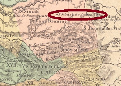
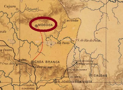
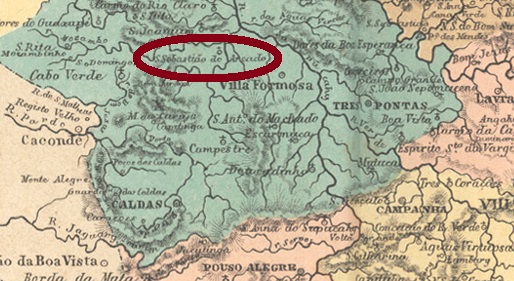
São Sebastião da Boa Vista had been a settlement of Casa Branca since December 1847, close to the border with Minas Gerais, about 260 km north of the provincial capital São Paulo. In April 1856, the place rose to a Freguesia and went as a district to Caconde for three years from April 1868, before returning to Casa Branca. Shortly afterwards it became a villa, and from April 1875 it has been a town called Mococa.
As can be read in the Imperial Mail Register (Tabella das Agencias do Correio do Imperio, Rio de Janeiro, 1885), there has been a post office there since 1870. Two imperial postmarks under this town name have been found. The first of these is certainly SSP-1860a (Coll. José A. Junges): a double ellipse with the inscriptions CORREIO above and DE S. SEBASTIÃO DA BOA VISTA below, separated by Maltese crosses on right and left. It was followed by SSP-1860b (Coll. Mario Celso Orsi Jr.): a double circle with the inscription S. S. DA BOA VISTA above. One copy, dated 1879 in the centre. From about 1886 onwards, all town stamps bore the inscription MOCOCA (for illustrations see R. Koester: Carimbologia XXVII).
J. M. Ribeiro Lisboa: Provincia de São Paulo, 1884
Siehe auch Mococa (R. Koester: Carimbologia XXVII)
São Sebastião da Boa Vista war seit Dezember 1847 eine Siedlung von Casa Branca, die nah an der Grenze zu Minas Gerais lag, ca. 260 km nördlich der Provinzhauptstadt São Paulo entfernt. Im April 1856 stieg der Ort zu Freguesia auf und ging ab April 1868 für drei Jahre als Distrikt von Caconde, bevor er wieder zu Casa Branca zurückkehrte. Kurz darauf wurde er eine Villa, und seit April 1875 ist es eine Stadt, die Mococa heißt.
Wie im Verzeichnis der kaiserlichen Postämter (Tabella das Agencias do Correio do Imperio, Rio de Janeiro, 1885) zu lesen ist, gibt es dort ein Postamt seit 1870. Zwei kaiserliche Stempel unter diesem Ortsnamen wurden gefunden. Der erste davon ist sicherlich SSP-1860a (Samml. José A. Junges): eine Doppelellipse mit den Inschriften CORREIO oben und DE S. SEBASTIÃO DA BOA VISTA unten, die durch Malteser Kreuze rechts und links getrennt sind. Danach kam SSP-1860b (Samml. Mario Celso Orsi Jr.): ein Doppelkreis mit der Inschrift S. S. DA BOA VISTA oben. Ein Exemplar, datiert 1879 in der Mitte. Ab ca. 1886 trugen alle Ortsstempel die Inschrift MOCOCA (Abb. siehe R. Koester: Carimbologia XXVII).
Carta da Republica dos Estados Unidos do Brasil, 1892
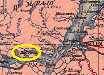
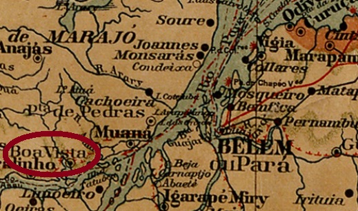
São Sebastião da Boa Vista was a freguesia of Muaná from October 1868, located on an island south of the famous Marajó Island, 120 km west of the provincial capital Belém do Pará. Thereafter, within 17 years, it was really promoted to villa status four times: in 1872, 1880, 1886 and 1889. Each promotion was followed by a relegation back to district status: in 1879, 1882, 1887 and finally in 1922, clearly reflecting the precarious situation of public administration in northern Brazil. It was not until December 1943 that the stable ascent as Município took place.
The local post office also had to be established at least twice. The first date of establishment could not be determined exactly, but took place by 1877, as the agency appears in a list of February 1881, which reports postal revenues locally in the 1877-1878 fiscal year. By 1881 the agency must have been closed, as a reopening in March 1882 was reported by the Rio press:
O Globo, 24 March 1882
So far, no imperial-era postmark from this locality has been found.
Mapa Geral do Brasil, 1911
São Sebastião da Boa Vista war ab Oktober 1868 eine Freguesia von Muaná, die auf einer Insel südlich der berühmten Marajó-Insel lag, 120 km Luftlinie westlich der Provinzhauptstadt Belém do Pará entfernt. Danach folgte binnen 17 Jahren tatsächlich viermal den Aufstieg zur Villa: 1872, 1880, 1886 und 1889. Jedem Aufstieg folgte ein Abstieg zurück zum Distrikt-Status: 1879, 1882, 1887 und zuletzt 1922, was die prekäre Situation der öffentlichen Verwaltung im Norden Brasiliens deutlich widerspiegelt. Erst im Dezember 1943 erfolgte der stabile Aufstieg als Município.
Auch das örtliche Postamt musste mindestens zweimal gegründet werden. Der erste Entstehungstermin konnte nicht exakt ermittelt werden, fand aber bis 1877 statt, da die Agentur in einer Liste vom Februar 1881 erscheint, die über Posteinnahmen vor Ort im Geschäftsjahr 1877-1878 berichtet. Um 1881 wurde die Agentur geschlossen, da eine Wiedereröffnung im März 1882 durch die Presse aus Rio publik wurde:
O Globo, 24. März 1882
Bisher konnte kein Poststempel der Kaiserzeit von dieser Ortschaft gefunden werden.
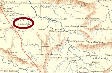
This São Sebastião “of the sandy soil” in the province of Minas Gerais was a district of Alfenas from September 1871, which at that time was located about 420 km west of the capital Ouro Preto. Today, the place is a holiday destination for tourists who want to visit the Furnas dam. In August 1911, the village rose to become a villa under the name Gomes – probably to pay homage to a prominent family in the region – but eight years later the old name (now shortened to Areado) returned.
Paula Sobrinho writes in História Postal de Minas Gerais (Belo Horizonte, 1997) that the local post office was created in September 1880. The only postmark of the imperial period so far is SMG-2620a (Coll. José A. Junges): a double circle with the inscription S. SEBASTIÃO DO AREADO above and an ornament in lozenge below, formed by four small diamonds. Dates inside from about 1880 to 1888.
Estrada de Ferro Central do Brasil, 1890
Andere Namen: Villa Gomes, Areado (1919)
Dieser São Sebastião “vom Sandboden” in der Provinz Minas Gerais war ab September 1871 ein Distrikt von Alfenas, der damals ca. 420 km westlich der Hauptstadt Ouro Preto entfernt lag. Heute ist der Ort ein Urlaubsziel für Touristen, die den Furnas-Staudamm besuchen möchten. Im August 1911 stieg der Ort zur Villa unter dem Namen Gomes – wohl um einer prominenten Familie der Region die Ehre zu erweisen – aber acht Jahre später kam der alte Name (nun verkürzt zu Areado) doch zurück.
Paula Sobrinho schreibt in História Postal de Minas Gerais (Belo Horizonte, 1997), dass das örtliche Postamt vom September 1880 ist. Der bisher einzige Poststempel der Kaiserzeit ist SMG-2620a (Samml. José A. Junges): ein Doppelkreis mit der Inschrift S. SEBASTIÃO DO AREADO oben und einem Ornament in Raute unten, das aus vier kleinen Rauten gebildet wird. Daten in Inneren von ca. 1880 bis 1888.
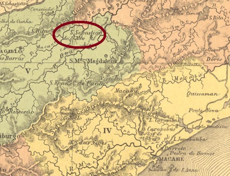
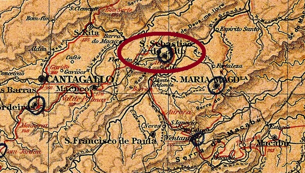
São Sebastião do Alto (= of the Heights) was a freguesia of S. Francisco de Paula from September 1855, located just under 220 km northeast of the capital Rio de Janeiro. In April 1891, the place rose to the status of a villa and became a town in December 1929.
Nova Monteiro writes in Administrações e Agencias Postaes do Brasil Imperio (in Brasil Filatelico/RJ, 1934-5; reprint SPP 1994-1999) that there has been a post office there since June 1855. However, Aureo G. Santos noted in Agências de Correio Criadas e Suprimidas 1851, 1855, 1856 e 1857, (in Brasil Filatélico 181, Rio de Janeiro, 1977) a date exactly one month later:
Aureo G. Santos (op. cit.)
Anyway, Paulo Novaes has found out that the post office closed in June 1861, only to reopen three months later (agenciaspostais.com.br).
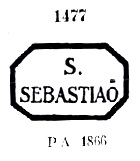
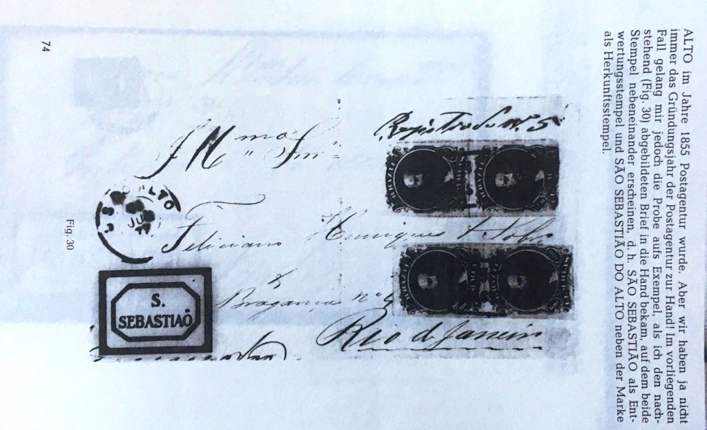
Three postmarks in double circle were found for the 19th century. But before them there was SRJ-0955a; this cancel was in circulation at least until 1877 and is usually assigned to São Sebastião in São Paulo, since the addition DO ALTO is missing here. It is listed in P. Ayres (Catálogo de Carimbos Brasil-Império, S. Paulo, 1937, 1942) under no. 1477 and could be identified beyond doubt by a cover from the R. Koester collection:
SRJ-0955a (P.A. 1477)Collection R. Koester
On SRJ-0955b (Coll. José A. Junges) the inscription at the top reads S. S. DO ALTO, the dates inside go from 1877 to 1884. This was followed by SRJ-0955c (coll. Karlheinz Wittig): the inscription at the top is now S. SEBASTIÃO DO ALTO, at the bottom one sees an ornament in lozenge formed by four small lozenges. The dates in the middle go from 1886 to 1890. SRJ-0955d (fig. from the internet) might be republican, as this stamp so far shows dates from 1890 onwards. The inscription at the top is now SEBASTIÃO DO ALTO (without SÃO), at the bottom the ornament is an X.
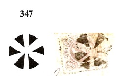
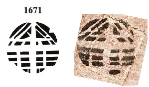
Two mute cancellations (both Coll. José A. Junges) were also found which could be assigned to Nos. 347 and 1671 in Mute Cancellations of the Brazil Empire/ Carimbos Mudos do Brasil Império (Brazil Philatelic Association, Rio de Janeiro, 2000) by J. Dingler and K. Lopes:
São Sebastião do Alto (= der Höhe) war ab September 1855 eine Freguesia von S. Francisco de Paula, die knapp 220 km nordöstlich der Hauptstadt Rio de Janeiro entfernt lag. Im April 1891 stieg der Ort zur Villa auf und wurde eine Stadt im Dezember 1929.
Nova Monteiro schreibt in Administrações e Agencias Postaes do Brasil Imperio (in Brasil Filatelico/RJ, 1934-5; Reprint SPP 1994-1999), dass es dort ein Postamt seit Juni 1855 gibt. Allerdings hat Aureo G. Santos in Agências de Correio Criadas e Suprimidas 1851, 1855, 1856 e 1857, (in Brasil Filatélico 181, Rio de Janeiro, 1977) ein Datum notiert, das exakt ein Monat später liegt:
Aureo G. Santos (op. cit.)
Wie es dem auch sei, Paulo Novaes fand heraus, dass das Postamt im Juni 1861 geschlossen wurde, um drei Monate später wieder zu öffnen (agenciaspostais.com.br).
Es wurden drei Poststempel im Doppelkreis für den 19. Jahrhundert gefunden. Davor aber kam SRJ-0955a; dieser Stempel war zumindest bis 1877 im Umlauf und wird meistens São Sebastião in São Paulo zugeordnet, da der Zusatz DO ALTO hier fehlt. Er wird im P. Ayres (Catálogo de Carimbos Brasil-Império, S. Paulo, 1937, 1942) unter Nr. 1477 aufgeführt und konnte durch einen Beleg aus der Sammlung R. Koester zweifelsfrei identifiziert werden:
SRJ-0955a (P.A. 1477)Sammlung R. Koester
Bei SRJ-0955b (Samml. José A. Junges) lautet die Inschrift oben S. S. DO ALTO, die Daten im Inneren gehen von 1877 bis 1884. Es folgte SRJ-0955c (Samml. Karlheinz Wittig): die Inschrift oben ist nun S. SEBASTIÃO DO ALTO, unten sieht man ein Ornament in Raute, das durch vier kleine Rauten gebildet wird. Daten in der Mitte von 1886 bis 1890. SRJ-0955d (Abb. aus dem Internet) dürfte evtl. republikanisch sein, da dieser Stempel bisher Daten ab 1890 aufweist. Die Inschrift oben ist nun SEBASTIÃO DO ALTO (Ohne SÃO), unten ist das Ornament ein X.
Zwei stumme Abstempelungen (beide Samml. José A. Junges) wurden darüber hinaus gefunden, die den Nr. 347 und 1671 in Mute Cancellations of the Brazil Empire/ Carimbos Mudos do Brasil Império (Brazil Philatelic Association, Rio de Janeiro, 2000) von J. Dingler und K. Lopes zugeordnet werden konnten:
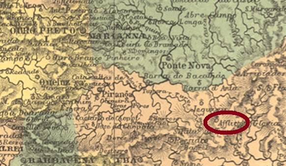
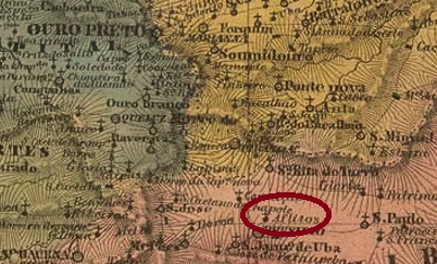
This São Sebastião in the province of Minas Gerais has also experienced several changes in place name. First, from April 1839, the place was a district of Ubá, under the name Capella Nova, which was about 160 km southeast of the provincial capital, Ouro Preto. In June 1853, the name changed to São Sebastião dos Aflictos (St. Sebastian of the Distressed), and in July 1886 to S. Sebastião do Herval (= of The Herb Meadow). During the Republic, the district’s name changes continued unabated: in September 1923 to Erval, which has been a Município since December 1938, and in December 1943 to Ervália, which is still current today.
As Paula Sobrinho writes in História Postal de Minas Gerais (Belo Horizonte, 1997), there has been a post office there since March 1881, and two Imperial postmarks have been found. On SMG-2657a (Coll. José A. Junges) one still reads S. SEBASTIÃO DOS AFLICTOS above, below is an ornament in lozenge formed by four small diamonds, the dates inside so far go from 1887 to 1888, i.e. from the time when the next place name was actually already valid. SMG-2635a (Coll. José A. Junges) duly reads S. SEBASTIÃO DO HERVAL above and (MINAS) below. Dated 1889-1900 at the centre.
Villiers de l’Ile Adam: Carta (…) da Provincia de Minas Geraes, 1849
Andere Namen: Capella Nova, Ervália (1943)
Auch dieser São Sebastião in der Provinz Minas Gerais hat mehrere Wechsel im Ortsnamen erlebt. Zunächst war der Ort ab April 1839 ein Distrikt von Ubá, unter dem Namen Capella Nova, der ca. 160 km südöstlich der Provinzhauptstadt Ouro Preto entfernt lag. Im Juni 1853 wechselte der Name zu São Sebastião dos Aflictos (Hl. Sebastian der Notleidende), und im Juli 1886 zu S. Sebastião do Herval (= Der Kräuterwiese). In der Republik ging der Namenwechsel des Distrikts munter weiter: im September 1923 zu Erval, der seit Dezember 1938 ein Município ist, und im Dezember 1943 zum heute noch aktuellen Ervália.
Wie Paula Sobrinho im História Postal de Minas Gerais (Belo Horizonte, 1997) schreibt, gibt es dort ein Postamt seit März 1881. Zwei Poststempel des Kaiserreichs wurden gefunden. Bei SMG-2657a (Samml. José A. Junges) liest man noch S. SEBASTIÃO DOS AFLICTOS oben, unten ist ein Ornament in Raute, das aus vier kleinen Rauten gebildet wird, die Daten im Inneren gehen bisher von 1887 bis 1888, also aus der Zeit, als der nächste Ortsname eigentlich schon gültig war. Bei SMG-2635a (Samml. José A. Junges) steht ordnungsgemäß S. SEBASTIÃO DO HERVAL oben und (MINAS) unten. Datiert 1889-1900 in der Mitte.
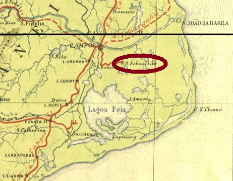
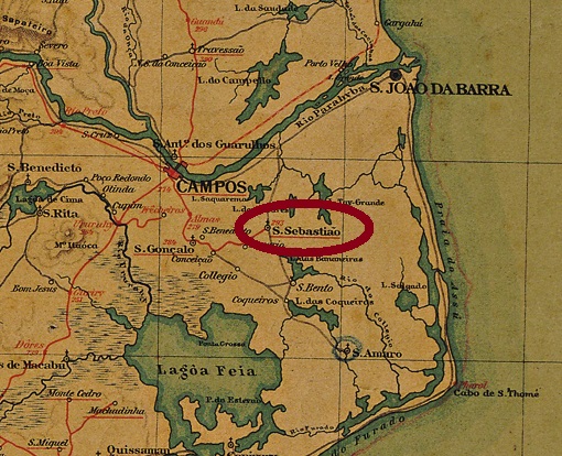
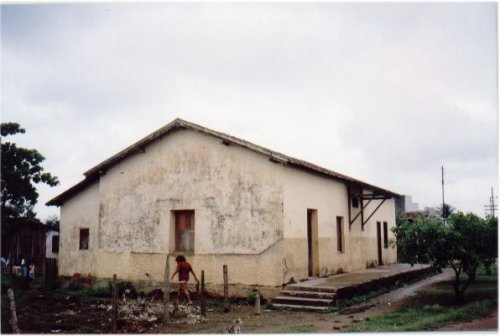
The São Sebastião railway station in the province of Rio was inaugurated in December 1873 by the Estrada de Ferro de Campos a São Sebastião railway company and was located near Campos, about 290 km northeast of the capital Rio de Janeiro. In 1889, the railway line changed to the Estrada de Ferro de Macahé a Campos company and about 10 years later to the E. F. Leopoldina. From 1975 until the end of operations in 1996, it belonged to Rede Ferroviária Federal. The station was renamed Mineiros around 1892, in the last period it is said to have been called José (or João) Amaro. Today the rails are gone, and there was only one picture of the station, which has since disappeared from the corresponding website estacoesferroviarias.com.br.
ex estacoesferroviarias.com.br
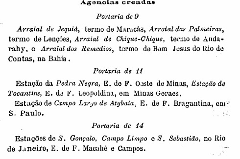
The station post office was created on November 14 November 1889, exactly the day before the military coup that ended the Brazilian Empire:
Boletim Postal, December 1889
It is very unlikely that a postmark date of 14 or 15 November will ever appear. SRJ-1485a (coll. R. Koester) is a double circle with the inscriptions EST. DE S. SEBASTIÃO above and (E.F.M. E CAMPOS) below. The only copy so far has a date of 1890 inside.
Almnak Laemmert, 1892
Andere Namen: Mineiros, José Amaro
Der Bahnhof São Sebastião in der Provinz Rio wurde im Dezember 1873 durch die Bahngesellschaft Estrada de Ferro de Campos a São Sebastião eingeweiht und lag bei Campos, ca. 290 km nordöstlich der Hauptstadt Rio de Janeiro entfernt. 1889 wechselte die Bahnhlinie zur Gesellschaft Estrada de Ferro de Macahé a Campos und ca. 10 Jahre später zur E. F. Leopoldina. Von 1975 bis zum Betriebsende 1996 gehörte sie der Rede Ferroviária Federal. Der Bahnhof wurde um 1892 zu Mineiros umbenannt, in der letzten Periode soll er José (oder João) Amaro geheißen haben. Heute sind die Schienen weg, und vom Bahnhof gab es nur ein Bild, das inzwischen von der entsprechenden Website estacoesferroviarias.com.br verschwunden ist.
ex estacoesferroviarias.com.br
Das Bahnhofspostamt entstand am 14.11.1889, genau am Tag vor dem Militärputsch, der das brasilianische Kaiserreich beendet hat:
Boletim Postal, Dezember 1889
Es ist sehr unwahrscheinlich, dass jemals ein Stempeldatum vom 14. oder 15. November erscheint. SRJ-1485a (Samml. R. Koester) ist ein Doppelkreis mit den Inschriften EST. DE S. SEBASTIÃO oben und (E.F.M. E CAMPOS) unten. Das bisher einzige Exemplar hat innen ein Datum aus 1890.
This station post office is a special case whose story still has blanks to fill in. It had four different names in less than 15 years – with corresponding postmarks – and two other place names followed. Furthermore, it is not yet clear when exactly the station was built, but apparently the post office started operations beforehand.
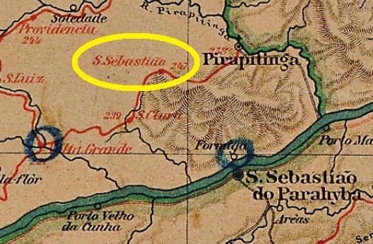
The railway line between Volta Grande and Sant’Anna de Pirapetinga in the province of Minas Geraes was planned in the late 1860s by the Companhia União e Industria. Although the client was the Estrada de Ferro do Pirapetinga railway company, this has operated the line for a very short time, if at all, because the E. F. Leopoldina already acted as a line owner at the end of 1879.
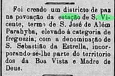
The station was in the municipality of Sao José d’Além Parahyba, about 320 km southeast of the provincial capital Ouro Preto, and was intended to serve the municipalities on both banks of the Parahyba River, especially São Sebastião do Parahyba in the province of Rio de Janeiro. Since the postal system was then managed from Rio, the station post office was given the name of São Sebastião. Three inauguration dates for the station have been found: first in October 1874 (Paula Sobrinho: História Postal de Minas Gerais, Belo Horizonte, 1997), then in December 1879 (A Actualidade, 21.01.1880) and finally in 1880 (estacoesferroviarias.com.br).
But this station had probably been given another name, São Vicente – now by the province of Minas Gerais. As a result, not only were two different postmarks in circulation at the post office, but the post office was also listed twice in the 1885 Imperial Mail Register (Tabella das Agencias do Correio do Imperio).
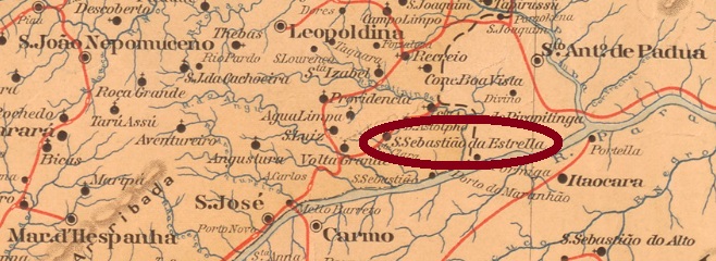
To defuse this confused situation in Solomon terms, in 1882 the provincial parliament in Ouro Preto decided by Provincial Law No. 2.988 to declare the village as a district and to call it henceforth São Sebastião da Estrella:
Pharol, 9 January 1883
However, it took a while for this place name to appear in the stamps; before that, the name of São Sebastião do Pirapetinga was added, apparently without any legal basis. A relatively quiet time followed. It was not until December 1938 that the district was renamed Estrella, and exactly five years later the district was given the name Estrela Dalva, which has been a municipality since December 1953.
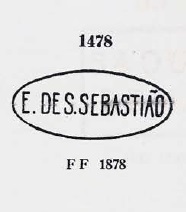
There are four creation dates for the station post office: 1872 (Tabella/1885), April 1877 (O Globo/RJ, 05.04.1877), December 1879 (O Apostolo, 31.12.1879) and July 1881 (Paula Sobrinho, op. cit.). The first postmark of this station is SMG-2575a, which was already shown by Paulo Ayres in Catalogo de Carimbos Brasil-Império (S. Paulo, 1937, 1942) under No. 1478:
SMG-2575a (P.A. 1478) 1872-1883ff
It was followed by four cancels with double circles. SMG-2575b (Coll. José A. Junges) is also available in blue and has above the inscription E. DE S. SEBASTIÃO, with dates inside from 1881 to 1883ff. SMG-2647a (Coll. Karlheinz Wittig) is also found in blue and has the inscriptions S. SEBASTIÃO DO PIRAPETA. above and (ESTAÇÃO) below. It is dated inside from 1884ff to 1890. SMG-2668a (Coll. José A. Junges) has the inscription S. VICENTE (ESTAÇÃO) above, with dates from 1883ff to 1889 inside. Finally, SMG-2586a (image from the Internet) is likely to be Republican, since the internal dates go from 1891 to 1903. Here are the inscriptions S. SEBASTIÃO DA ESTRELLA above and (M.G.) below.
Mappa de Minas Geraes, 1910
Andere Namen: Estrela (1938), Estrela Dalva (1943)
Dieses Bahnhofpostamt ist ein Sonderfall, dessen Geschichte noch lange nicht zu Ende erzählt wurde. Es hatte vier verschiedene Namen in weniger als 15 Jahren – mit entsprechenden Poststempeln – und weitere zwei Ortsnamen sind später dazu gekommen. Dann ist es noch nicht klar, wann genau der Bahnhof erbaut wurde, aber offenbar nahm das Postamt seinen Betrieb vorher auf.
Die Bahnlinie zwischen Volta Grande und Sant’Anna de Pirapetingain der Provinz Minas Geraes wurde ab Ende der 1860er Jahre von der Companhia União e Industria geplant und gebaut. Auftraggeber war zwar die Estrada de Ferro do Pirapetinga Bahngesellschaft, die aber – wenn überhaupt – sehr kurze Zeit die Linie betrieben hat, denn bereits Ende 1879 fungierte die E. F. Leopoldina als Linieninhaberin.
Der Bahnhof lag im Município von São José d’Além Parahyba, ca. 320 km südöstlich der Provinzhauptstadt Ouro Preto entfernt, und sollte die Gemeinden an beiden Ufern des Flusses Parahyba bedienen, besonders São Sebastião do Parahyba in der Provinz Rio de Janeiro. Da das Postwesen zunächst von Rio aus verwaltet wurde, bekam das Bahnhofspostamt zunächst den Namen São Sebastião. Drei Einweihungsdaten für den Bahnhof sind überliefert: erstmals im Oktober 1874 (Paula Sobrinho: História Postal de Minas Gerais, Belo Horizonte, 1997), dann im Dezember 1879 (A Actualidade, 21.01.1880), und zuletzt 1880 (estacoesferroviarias.com.br).
Nun aber hatte dieser Bahnhof einen anderen Namen – São Vicente – wohl von der Provinz Minas Gerais verpasst bekommen. Dies hatte zur Folge, dass nicht nur bald zwei unterschiedliche Poststempel an der Post im Umlauf waren, sondern auch das Postamt zweimal imVerzeichnis der kaiserlichen Postämter (Tabella das Agencias do Correio do Imperio, Rio de Janeiro, 1885) aufgelistet ist.
Um diese konfuse Lage salomonisch zu entzerren, entschied sich 1882 das Provinzparlament in Ouro Preto durch das Provinzialgesetz Nr. 2.988 dafür, die Ortschaft als Distrikt zu erklären und fortan São Sebastião da Estrella zu nennen:
Pharol, 9. Januar 1883
Es dauerte jedoch eine Weile, bis dieser Ortsname in den Stempeln erschien; dazwischen kam noch – scheinbar ganz ohne gesetzliche Grundlage – der Name São Sebastião do Pirapetinga. Es folgte eine relativ ruhige Zeit. Erst im Dezember 1938 kam die nächste Umbenennung als Distrikt von Estrella, und genau fünf Jahre später bekam der Distrikt den heute noch gültigen Namen Estrela Dalva, der seit Dezember 1953 ein Municipio ist.
Fürs Bahnhofspostamt gibt es vier Gründungsdaten: 1872 (Tabella/1885), April 1877 (O Globo/RJ, 05.04.1877), Dezember 1879 (O Apostolo, 31.12.1879) und auch den Juli 1881 (Paula Sobrinho, op.cit.). Der erste Poststempel dieses Bahnhofs ist SMG-2575a, der bereits durch Paulo Ayres in Catálogo de Carimbos Brasil-Império (S. Paulo, 1937, 1942) mit Nr. 1478 gezeigt wurde:
SMG-2575a (P.A. 1478) 1872-1883ff
Ihm folgten vier Stempel mit Doppelkreisen. SMG-2575b (Samml. José A. Junges) kommt auch in blau vor und hat oben die Inschrift E. DE S. SEBASTIÃO, mit Daten im Inneren von 1881 bis 1883ff. SMG-2647a (Samml. Karlheinz Wittig) kommt ebenfalls in blau vor und hat die Inschriften S. SEBASTIÃO DO PIRAPETA. oben und (ESTAÇÃO) unten. Daten 1884ff bis 1890 innen. SMG-2668a (Samml. José A. Junges) hat die Inschrift S. VICENTE (ESTAÇÃO) oben, mit Daten von 1883ff bis 1889 im Inneren. Und schließlich SMG-2586a (Abb. aus dem Internet) dürfte bereits republikanisch sein, da die inneren Daten von 1891 bis 1903 gehen. Hier lauten die Inschriften S. SEBASTIÃO DA ESTRELLA oben und (M.G.) unten.
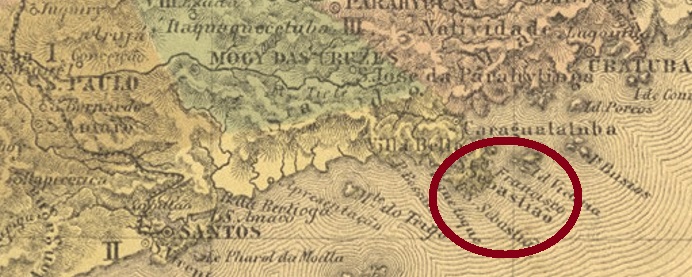
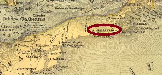
This very old town by Brazilian standards was already a villa in March 1636, picturesquely and sheltered on the Atlantic coast off the island of Ilhabela, barely 200 km west of the later provincial capital of São Paulo. São Sebastião has been a city since April 1875.
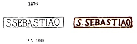
Two creation years were found for the local post office. Nova Monteiro, in Administrações e Agencias Postaes do Brasil Imperio (in Brasil Filatelico/RJ, 1934-5; Reprint SPP 1994-1999) writes April 1828, while the Imperial Mail Register (Tabella das Agencias do Correio do Imperio, Rio de Janeiro, 1885) lists the agency from 1847. The first postmark is SSP-1230a, used at least until 1866 and already presented by Paulo Ayres in Catálogo de Carimbos Brasil-Império (S. Paulo, 1937, 1942). However, the later illustration by the RHM catalogue shows considerable differences to Ayres’ version:
SSP-1230a (P.A. 1476, RHM P-SP-52)
The following local cancel was SSP-1230b (Coll. Mario Orsi Jr.): a double circle with the inscription S. SEBASTIÃO at the top, with internal dates between 1883 and 1887. Next came the French type SSP-1230c (image from the Internet): in this double circle the inscription at the top is now SÃO – SEBASTIÃO, with the tilde here floating between A and O. Interior dates so far from 1890 to 1901.
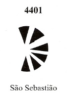
James A. Dingler and Klerman W. Lopes also show a mute cancel supposedly from S. Sebastião under no. 4401 in Mute Cancellations of the Brazil Empire / Carimbos Mudos do Brasil Império, (Brazil Philatelic Association, Rio de Janeiro, 2000):
BPA 4401Villiers de l’Ile Adam: Carta (..) da Provincia de S. Paulo, 1847
Textaktualisierung vom 9. September 2021
Dieser für brasilianische Verhältnisse sehr alte Ort war bereits im März 1636 eine Villa, die malerisch und geschützt an der Atlantikküste vor der Insel Ilhabela lag, knapp 200 km östlich der späteren Provinzhauptstadt São Paulo entfernt. Seit April 1875 ist São Sebastião eine Stadt.
Zwei Gründungsjahre fürs örtliche Postamt sind überliefert. Nova Monteiro schreibt dafür in Administrações e Agencias Postaes do Brasil Imperio (in Brasil Filatelico/RJ, 1934-5; Reprint SPP 1994-1999) den April 1828, während das Verzeichnis der kaiserlichen Postämter (Tabella das Agencias do Correio do Imperio, Rio de Janeiro, 1885) die Agentur ab dem Jahr 18847 auflistet. Der erste Poststempel ist SSP-1230a, der mindestens bis 1866 gebraucht und bereits durch Paulo Ayres in Catálogo de Carimbos Brasil-Império (S. Paulo, 1937, 1942) vorgestellt wurde. Allerdings zeigt die spätere Abbildung durch den RHM-Katalog erhebliche Unterschiede zu Ayres’ Vorlage:
SSP-1230a (P.A. 1476, RHM P-SP-52)
Der nächste Ortsstempel ist SSP-1230b (Samml. Mario Orsi Jr.): ein Doppelkreis mit der Inschrift S. SEBASTIÃO oben, mit inneren Daten zwischen 1883 und 1887. Danach kam der Französische Typus SSP-1230c (Abb. aus dem Internet): in diesem Doppelkreis lautet die Inschrift oben nun SÃO – SEBASTIÃO, wobei hier die Tilde zwischen A und O schwebt. Innere Daten bisher von 1890 bis 1901.
James A. Dingler und Klerman W. Lopes zeigen darüber hinaus in Mute Cancellations of the Brazil Empire / Carimbos Mudos do Brasil Império, (Brazil Philatelic Association, Rio de Janeiro, 2000) einen stummen Stempel – vermutlich aus diesem S. Sebastião – unter Nr. 4401:
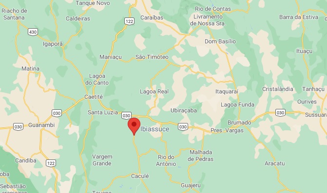
Other names: São Sebastião do Caetité, Ibiassucê (1938).
This locality was formerly called São Sebastião do Caetité and was a district of Caetité from July 1880, situated over 600 km west of the provincial capital Salvador da Bahia. In August 1890, the district changed to Caculé and in November 1938 it received the name Ibiassucê, which is still current today. The word has Indian origins and is said to mean plateau highland. Since July 1962, Ibiassucê has been a município.
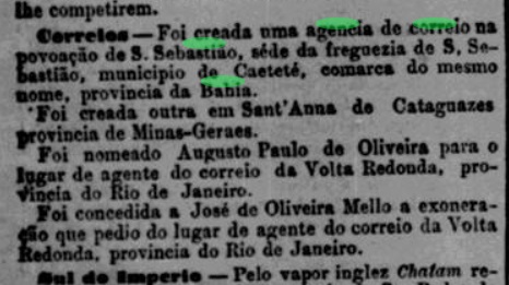
The local post office was established in March 1885, according to the Rio press:
Jornal do Commercio/RJ, 20 March 1885
So far, no postmark from the Empire could be surely assigned to this locality.
Google Maps
Andere Namen: São Sebastião do Caetité, Ibiassucê (1938)
Diese Ortschaft hieß früher São Sebastião do Caetité und war ab Juli 1880 ein Distrikt von Caetité, der über 600 km westlich der Provinzhauptstadt Salvador da Bahia entfernt lag. Im August 1890 wechselte der Distrikt zu Caculé und erhielt im November 1938 den heute noch aktuellen Namen Ibiassucê. Das Wort hat indianischen Ursprung und soll Plateauhochland bedeuten. Seit Juli 1962 ist Ibiassucê ein Município.
Das örtliche Postamt wurde im März 1885 ins Leben gerufen, wie die Presse aus Rio mitteilte:
Jornal do Commercio/RJ, 20. März 1885
Bisher konnte kein Poststempel aus dem Kaiserreich dieser Ortschaft mit Sicherheit zugeordnet werden.
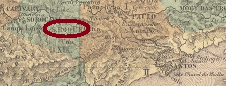
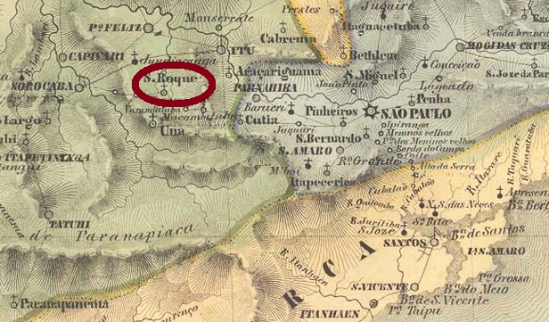
This old village had been a freguesia at Sant’Anna do Parnahyba since 1768, located on the important trade route between São Paulo and Sorocaba, about 60 km west of the provincial capital. In June 1832 the place rose to a villa and in April 1864 to a town.
Two creations of the local post office were registered. Nova Monteiro (Administrações e Agencias Postaes do Brasil Imperio, in BrasilFilatelico/RJ, 1934-5; Reprint SPP 1994-1999) writes May 1833 for it, while in the Imperial Mail Register (Tabella das Agencias do Correio do Imperio, Rio de Janeiro, 1885) the agency is listed from 1847. So, it was closed sometime after 1843 in between.
Three local cancels and one mute cancellation are present. SSP-1225a is clearly the oldest of these, having been found on Bull’s Eyes issued in 1843:
SSP-1225a (RHM) c. 1833-1843ff
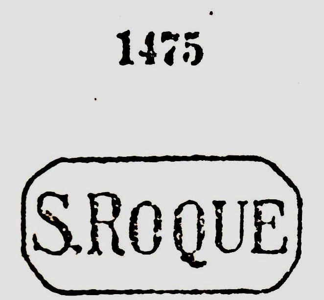
It was followed by SSP-1225b, a cancel in use at least until 1868 and already introduced by Paulo Ayres (Catálogo de Carimbos Brasil-Império, S. Paulo, 1937, 1942) under no. 1475:
SSP-1225b (P.A. 1475) 1866ff-1868
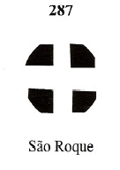
The third local cancel is the double circle SSP-1225c (Coll. Karlheinz Wittig), with the inscription S. ROQUE at the top. Dates in the centre from 1895 to 1896, although sometimes the year may be missing. The mute cancel has already been presented by J.A. Dingler and K. W. Lopes in Mute Cancellations of the Brazil Empire / Carimbos Mudos do Brasil Império (Brazil Philatelic Association, Rio de Janeiro, 2000) under no. 287:
BPA 287Villiers de l’Ile Adam: Carta (..) da Provincia de S. Paulo, 1847
Diese alte Ortschaft war seit 1768 eine Freguesia bei Sant’Anna do Parnahyba, die auf dem wichtigen Handelsweg zwischen São Paulo und Sorocaba lag, ca. 60 km westlich der Provinzhauptstadt entfernt. Im Juni 1832 stieg der Ort zur Villa und im April 1864 zur Stadt auf.
Zwei Gründungen des Postamtes wurden registriert. Nova Monteiro (Administrações e Agencias Postaes do Brasil Imperio, in Brasil Filatelico/RJ, 1934-5; Reprint SPP 1994-1999) schreibt dafür den Mai 1833, während im Verzeichnis der kaiserlichen Postämter (Tabella das Agencias do Correio do Imperio, Rio de Janeiro, 1885) die Agentur ab 1847 geführt wird. Also wurde sie irgendwann nach 1843 mal geschlossen.
Drei Ortsstempel und eine stumme Entwertung sind vorhanden. SSP-1225a ist eindeutig die älteste davon, da sie auf Ochsenaugen von 1843 gefunden wurde:
SSP-1225a (RHM) ca. 1833-1843ff
Ihr folgte SSP-1225b, ein Stempel, der zumindest bis 1868 im Gebrauch war und bereits durch Paulo Ayres (Catálogo de Carimbos Brasil-Império, S. Paulo, 1937, 1942) unter Nr. 1475 vorgestellt wurde:
SSP-1225b (P.A. 1475) 1866ff-1868
Der dritte Ortsstempel ist der Doppelkreis SSP-1225c (Samml. Karlheinz Wittig), mit der Inschrift S. ROQUE oben. Daten in der Mitte von 1895 bis 1896, wobei manchmal die Jahresangabe fehlen kann. Der stumme Stempel wurde bereits durch J.A. Dingler und K. W. Lopes in Mute Cancellations of the Brazil Empire / Carimbos Mudos do Brasil Império (Brazil Philatelic Association, Rio de Janeiro, 2000) unter Nr. 287 präsentiert: