Categories
Carimbologia S

São Roque, Minas Gerais (SMG-2570)

Atlas do Imperio do Brasil, 1868

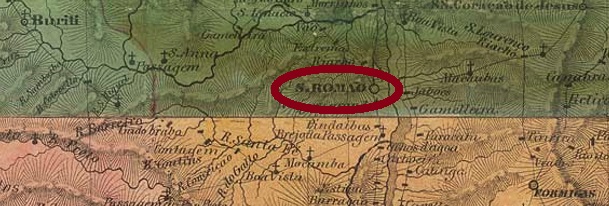
Other names: Guia Lopes, São Roque de Minas (1962).

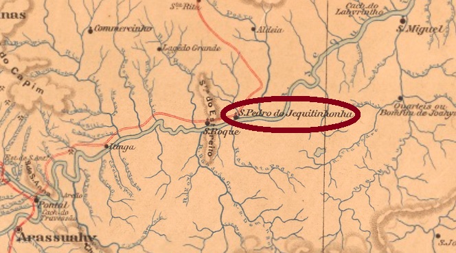
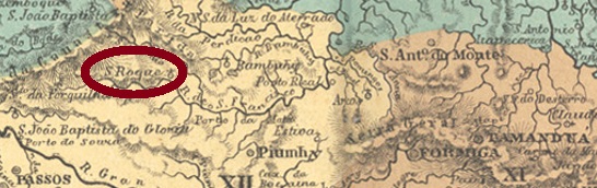
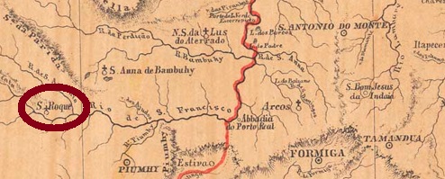
São Roque in the province of Minas Gerais was, from June 1858, a district of the municipality of Piumhy, located on the Serra da Canastra, over 400 km west of the capital Ouro Preto. In December 1938, it became the Município of Guia Lopes. The name was meant to celebrate the leader (“Guia”) José Francisco Lopes (1811-1868), a native of São Roque and hero of the war against Paraguay (1864-1870), for he saved many Brazilian families from certain death in 1868 by successfully leading them out of the war zone near Laguna in Mato Grosso, but dying of cholera himself. However, the national hero did not find favour with his compatriots, and the Município has now been called São Roque de Minas since December 1962. 

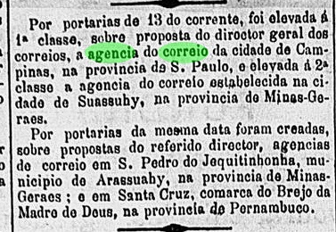
As Paula Sobrinho writes in História Postal de Minas Gerais (Belo Horizonte, 1997), there had been a post office there since November 1881, which is confirmed by the press from Rio de Janeiro:

Gazeta de Noticias/RJ, November 25, 1881

The postmark of the imperial period is SMG-2570a (Coll. Márcio Protzner): a double circle with the inscription S. ROQUE above and a diamond ornament below, consisting of four small lozenges. The only specimen found so far has a date from 1889 in the centre.

Mappa de Minas Geraes, 1873

Andere Namen: Guia Lopes, São Roque de Minas (1962)

São Roque in der Provinz Minas Gerais war ab Juni 1858 ein Distrikt von der Gemeinde Piumhy, der an der Serra da Canastra lag, über 400 km westlich der Hauptstadt Ouro Preto entfernt. Im Dezember 1938 wurde daraus der Município von Guia Lopes. Der Name sollte an den Führer („Guia“) José Francisco Lopes (1811-1868) erinnern, ein gebürtiger São Roquense, der als Held des Krieges gegen Paraguay (1864-1870) gefeiert wird, seitdem er 1868 viele brasilianische Familien vom sicheren Tod gerettet hat, indem er sie aus dem Kriegsgebiet bei Laguna im Mato Grosso erfolgreich geführt hatte und dabei selbst an Cholera starb. Der Nationalheld fand jedoch kein Gefallen bei seinen Landsleuten, und der Município heißt nun seit Dezember 1962 São Roque de Minas.  

Wie Paula Sobrinho in História Postal de Minas Gerais (Belo Horizonte, 1997) schreibt, gab es dort ein Postamt seit November 1881, was durch die Presse aus Rio de Janeiro bestätigt wird:

Gazeta de Noticias/RJ, 25.11.1881

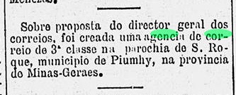
Der Poststempel der Kaiserzeit ist SMG-2570a (Samml. Márcio Protzner): ein Doppelkreis mit der Inschrift S. ROQUE oben und einem Ornament in Rate unten, das aus vier kleinen Rauten besteht. Das einzig bisher gefundene Exemplar hat ein Datum aus 1889 in der Mitte.

Categories
Carimbologia S

São Romão, Minas Gerais (SMG-2565)

Atlas do Imperio do Brasil, 1868

Another name: Villa Rizonha de Santo Antonio da Manga de São Romão.

See also Villa Risonha (VMG-3825)

This village used to be a freguesia of Paracatu, located on the west bank of the São Francisco River, almost 590 km northwest of the provincial capital Ouro Preto. It rose to villa as early as October 1831, but a fever epidemic precipitated its decline. In March 1871, it became a district of Pedra dos Angicos, but it rose again to villa status in 1887, under the place name Villa Rizonha de São Romão. Since September 1923, it has been the town of São Romão.

Paula Sobrinho writes in História Postal de Minas Gerais (Belo Horizonte, 1997) that there was a post office there from October 1833. Two 19th century postmarks were found. The only copy of SMG-2565a (Coll. José A. Junges) was seen on a Dom Pedro issue of 1866 and shows a frameless legend S. ROMÃO. SMG-2565b (Coll. José A. Junges) is a double circle with the legend S. ROMÃO at the top, with the tilde floating between A and O. Dates inside between 1894 and 1906.

Villiers de l’Ile Adam: Carta (…) da Provincia de Minas Geraes, 1849

Anderer Name: Villa Rizonha de Santo Antonio da Manga de São Romão

Siehe auch Villa Risonha (VMG-3825)

Diese Ortschaft war früher eine Freguesia von Paracatu, die am Westufer des Flusses São Francisco lag, fast 590 km nordwestlich der Provinzhauptstadt Ouro Preto entfernt. Bereits im Oktober 1831 stieg sie zur Villa auf, aber eine Fieberepidemie leitete den Verfall ab. Im März 1871 wurde der Ort ein Distrikt von Pedra dos Angicos, der Wiederaufstieg zur Villa erfolgte 1887 unter den Ortsnamen Villa Rizonha de São Romão. Seit September 1923 ist es die Stadt São Romão.

Paula Sobrinho schreibt in História Postal de Minas Gerais (Belo Horizonte, 1997), dass es dort ab Oktober 1833 ein Postamt gab. Zwei Poststempel des 19. Jahrhunderts wurden gefunden. SMG-2565a (Samml. José A. Junges) wurde einzig auf einer Dom-Pedro-Ausgabe von 1866 gesehen und besteht aus einer rahmenlosen Legende S. ROMÃO. SMG-2565b (Samml. José A. Junges) ist ein Doppelkreis mit der Legende S. ROMÃO oben, wobei die Tilde zwischen A und O schwebt. Daten in der Mitte zwischen 1894 und 1906.

Categories
Carimbologia S

São Raymundo Nonato, Piauí (SPI-0150)

Atlas do Imperio do Brasil, 1868

This locality was a district of Jaicós from July 1832, located on the Piauí River, more than 520 km south of the future capital Teresina. In August 1850, it became a villa, which has been a town since June 1912. 

Two dates for the local post office were found. Nova Monteiro (Administrações e Agencias Postaes do Brasil Imperio, in Brasil Filatelico/RJ, 1934-5; Reprint SPP 1994-1999) writes October 1862 for it, while the Imperial Mail Register (Tabella das Agencias do Correio do Imperio, 1885) lists the agency as of 1882. Apparently, the post office was closed in between.

A postmark of the second period of operation is present. SPI-0150b (Coll. Karlheinz Wittig) is a double circle with the inscription S.R. NONATO at the top. Dates in the centre from 1885 to 1891.

Arthur D. Ribeiro: Estado do Piauhy, 1924

Diese Ortschaft war ab Juli 1832 ein Distrikt von Jaicós, der am Fluss Piauí lag, über 520 km südlich der späteren Hauptstadt Teresina entfernt. Im August 1850 wurde daraus eine Villa, die sich seit Juni 1912 eine Stadt nennen darf.  

Zwei Zeitpunkte fürs örtliche Postamt wurden gefunden. Nova Monteiro (Administrações e Agencias Postaes do Brasil Imperio, in Brasil Filatelico/RJ, 1934-5; Reprint SPP 1994-1999) schreibt dafür den Oktober 1862, während im Verzeichnis der kaiserlichen Postämter (Tabella das Agencias do Correio do Imperio, 1885) die Agentur ab 1882 aufgelistet wird. Scheinbar war das Postamt zwischendurch geschlossen.

Ein Poststempel der zweiten Betriebszeit ist vorhanden. SPI-0150b (Samml. Karlheinz Wittig) ist ein Doppelkreis mit der Inschrift S. R. NONATO oben. Daten in der Mitte von 1885 bis 1891.

Categories
Carimbologia S

São Pedro do Turvo, São Paulo (SSP-1220)

J.M. Ribeiro Lisboa: Provincia de São Paulo, 1884

São Pedro de Campos Novos do Turvo was a freguesia in the Município of Lençois from July 1875, located at the confluence of the São Pedro River and the São João, over 360 km west of the provincial capital of São Paulo. A year later, the place passed as a freguesia to the Município of Santa Cruz do Rio Pardo. In May 1891, it was promoted to a villa, and since December 1906, São Pedro do Turvo has been a town.

There are two foundation years for the local post office. The Imperial Mail Register (Tabella das Agencias do Correio do Imperio, Rio de Janeiro, 1885) shows the year 1876, while philatelist Mario Celso Orsi Jr gives it as “ca. 1886”. Only one 19th century postmark has been found so far. The only copy of SSP-1220b so far (illustration from the internet) is unfortunately only half visible: a double circle with the inscription (S. PEDR)O DO TURVO at the top, dated 1891 at the centre.

Provincia de São Paulo, 1886

São Pedro de Campos Novos do Turvo war ab Juli 1875 eine Freguesia im Município von Lençois, die an der Mündung des Flusses São Pedro in den São João lag, über 360 km westlich der Provinzhauptstadt São Paulo entfernt. Ein Jahr später ging der Ort als Freguesia zum Município von Santa Cruz do Rio Pardo über. Im Mai 1891 folgte der Aufstieg zur Villa, und seit Dezember 1906 ist São Pedro do Turvo eine Stadt.

Es liegen zwei Gründungsjahre fürs örtliche Postamt vor. Im Verzeichnis der kaiserlichen Postämter (Tabella das Agencias do Correio do Imperio, Rio de Janeiro, 1885) liest man das Jahr 1876, während der Philatelist Mario Celso Orsi Jr dafür „ca. 1886“ nennt. Nur ein Poststempel im 19. Jahrhundert wurde bisher gefunden. Das bisher einzige Exemplar von SSP-1220b (Abb. aus dem Internet) ist leider nur zur Hälfte zu sehen: ein Doppelkreis mit der Inschrift (S. PEDR)O DO TURVO oben, datiert 1891 in der Mitte.

Categories
Carimbologia S

São Pedro de Suassuhy, Minas Gerais (SMG-2555)

Mappa de Minas Geraes, 1910

Another name: Tourinho (1923-1925)

This locality was, as of November 1882, a district in the Município of Suassuhy, located on the south bank of the Suassuhy Grande River, over 460 km north of the provincial capital of Ouro Preto. The word Suassuhy (now written Suaçuí) comes from the Tupi language and means River of the Deer. In September 1887, the village became part of the municipality of Pessanha as a district and was called Tourinho between September 1923 and January 1925, before the old name returned. Since December 1962, São Pedro do Suaçuí has been an independent município.

As Paula Sobrinho writes in História Postal de Minas Gerais (Belo Horizonte, 1997), there has been a post office there since September 1879. This information has not yet been confirmed. Rather, the regional press reports only in October 1887 that a post office was recently established there:

A União, 1 October 1887

A 19th century postmark was found: SMG-2555a (Coll. José A. Junges) is a double circle with the inscriptions S. PEDRO DE SUASSUHY above and (MINAS) below. The dates in the middle are so far from the period 1890-1894.

Google Maps

Anderer Name: Tourinho (1923-1925)

Diese Ortschaft war ab November 1882 ein Distrikt im Município von Suassuhy, der am Südufer des Flusses Suassuhy Grande lag, über 460 km nördlich der Provinzhauptstadt Ouro Preto. Das Wort Suassuhy (heute Suaçuí geschrieben) kommt aus der Tupi-Sprache und bedeutet Fluss der Hirsche. Im September 1887 ging der Ort als Distrikt zur Gemeinde Pessanha und hieß zwischen September 1923 und Januar 1925 Tourinho, bevor der alte Name zurückkehrte. Seit Dezember 1962 ist São Pedro do Suaçuí ein eigenständiger Município.

Wie Paula Sobrinho in História Postal de Minas Gerais (Belo Horizonte, 1997) schreibt, gibt es dort ein Postamt seit September 1879. Diese Angabe konnte bisher nicht bestätigt werden. Vielmehr berichtet die regionale Presse über ein neues Postamt vor Ort erst im Oktober 1887:

A União, 1. Oktober 1887

Ein Stempel im 19. Jahrhundert war zu finden: SMG-2555a (Samml. José A. Junges) ist ein Doppelkreis mit den Inschriften S. PEDRO DE SUASSUHY oben und (MINAS) unten. Die Daten in der Mitte entstammen bisher dem Zeitraum 1890-1894.

Categories
Carimbologia S

São Pedro e São Paulo, Rio de Janeiro (SRJ-1480)

Atlas do Imperio do Brasil, 1868

Other names: Macacos, Paracambi (1901).

This locality with the long name São Pedro e São Paulo do Ribeirão das Lages (Peter and Paul of the Stone Plate Creek) was, from May 1892, a district of Itaguahy, located on the north bank of the Guandu River, more than 80 km northwest of the capital Rio de Janeiro. After that, the place name changed twice: in December 1895 to Macacos (Monkeys) and six years later to Paracambi. The Tupi word means large forest by the wide river. Paracambi has been a separate município since August 1960.

As Paulo Novaes (agenciaspostais.com.br) writes, there has been a post office there since November 1875, and two imperial-era postmarks were found. SRJ-1480a also exists in violet, was in circulation until at least 1877 and was already presented by Paulo Ayres (Catálogo de Carimbos Brasil-Império, S. Paulo, 1937, 1942) under no. 1474.

SRJ-1480a (P.A. 1474) 1875-1877ff

It was followed by the “French type” SRJ-1480b (Coll. Henrique B. Ferreira): a double circle with the inscription S. PEDRO E S. PAULO above and the star between brackets below. Dates in the centre, found within the period 1883-1888.

Almanak Laemmert, 1892

Andere Namen: Macacos, Paracambi (1901)

Diese Ortschaft mit dem langen Namen São Pedro e São Paulo do Ribeirão das Lages (Peter und Paul vom Steinplattenbach) war ab Mai 1892 ein Distrikt vom Itaguahy, der am Nordufer des Flusses Guandu lag, über 80 km nordwestlich der Hauptstadt Rio de Janeiro entfernt. Danach wechselte der Ortsname zweimal: im Dezember 1895 zu Macacos (Affen) und sechs Jahre später zu Paracambi. Das Tupi-Wort bedeutet großer Wald am breiten Fluss. Paracambi ist seit August 1960 ein eigener Município.

Wie Paulo Novaes (agenciaspostais.com.br) schreibt, gibt es dort ein Postamt seit November 1875. Zwei Poststempel der Kaiserzeit wurden gefunden. SRJ-1480gibt es auch in violett, war im Umlauf bis zumindest 1877 und wurde bereits durch Paulo Ayres (Catálogo de Carimbos Brasil-Império, S. Paulo, 1937, 1942) unter Nr. 1474 vorgestellt.

SRJ-1480a (P.A. 1474) 1875-1877ff

Ihm folgte der „französische Typ“ SRJ-1480b (Samml. Henrique B. Ferreira): ein Doppelkreis mit der Inschrift S. PEDRO E S. PAULO oben und dem Stern zwischen Klammern unten. Zwei Exemplare gefunden, datiert 1883-1888 in der Mitte.

Categories
Carimbologia S

São Pedro do Jequitinhonha, Minas Gerais (SMG-2550)

Atlas do Imperio do Brasil, 1868

This village was a district in the Município of Arassuahy from January 1880, located near the São Pedro River, on the north bank of the Jequitinhonha, 660 km northeast of the provincial capital Ouro Preto. In March 1938, the place passed as a district to the newly created Município of Jequitinhonha and has remained so until today.

Paula Sobrinho writes in Historia Postal de Minas Gerais (Belo Horizonte, 1997) that the local post office was established in July 1882. But this is probably a transcription error, because the correct date was exactly one month earlier, as can be seen from the press in Rio:

O Globo/RJ, 14 June 1882.

Only one postmark in the 19th century is known: SMG-2550a (Coll. José A. Junges) is a double circle with the inscription S. PEDRO DO JEQUITINHONHA above and a diamond ornament below, the four sides of which are open. Dates in the centre from 1890 to 1896.

Mappa de Minas Geraes, 1910

Diese Gemeinde war ab Januar 1880 ein Distrikt im Município von Arassuahy, der nah am Fluss São Pedro am Nordufer des Jequitinhonha-Flusses lag, 660 km nordöstlich der Provinzhauptstadt Ouro Preto entfernt. Im März 1938 ging der Ort als Distrikt zum neu gegründeten Município von Jequitinhonha über, und so ist es bis heute geblieben.

Paula Sobrinho schreibt zwar in Historia Postal de Minas Gerais (Belo Horizonte, 1997), dass das örtliche Postamt im Juli 1882 entstanden ist. Das dürfte aber ein Abschreibfehler sein, denn das richtige Datum war genau ein Monat früher, wie aus der Presse in Rio hervorgeht:

O Globo/RJ, 14. Juni 1882

Nur ein Poststempel im 19. Jahrhundert ist bekannt: SMG-2550a (Samml. José A. Junges) ist ein Doppelkreis mit der Inschrift S. PEDRO DO JEQUITINHONHA oben und einem Ornament in Raute unten, deren vier Seiten offen sind. Daten in der Mitte von 1890 bis 1896.

Categories
Carimbologia S

São Pedro da Ibiapina, Ceará (SCE-0301)

Atlas do Imperio do Brasil, 1868

See also Ibiapina (R. Koester: Carimbologia XXII).

This locality was a district of São Benedicto from March 1842, situated 300 km west of the provincial capital, Fortaleza. Although it was promoted to a villa in November 1878, it lost this status in May 1931 and returned to São Benedicto as a district. Two years later the place became a villa again, and another five years after that a town, which has since then been called simply Ibiapina.

We know through Reinhold Koester that the local post office was established in March 1879.  Unfortunately, no imperial postmark has yet appeared under this name. For a cancel featuring only Ibiapina, see Koesters Carimbologia XXII.

Villiers de l’Ile Adam: Carta (…)da Provincia do Ceara, 1849

Siehe auch Ibiapina (R. Koester: Carimbologia XXII)

Diese Ortschaft war ab März 1842 ein Distrikt von São Benedicto, der 300 km westlich der Provinzhauptstadt Fortaleza entfernt lag. Sie stieg zwar im November 1878 zu einer Villa auf, verlor diesen Status jedoch im Mai 1931 und kehrte als Distrikt zu São Benedicto zurück. Zwei Jahre später wurde der Ort wieder eine Villa, und weitere fünf Jahre danach eine Stadt, die seitdem einfach Ibiapina heißt.

Von Reinhold Koester wissen wir, dass das örtliche Postamt im März 1879 entstanden ist. Leider ist bisher kein Poststempel im Kaiserreich mit dem vollständigen Ortsnamen aufgetaucht. Ein Siegelstempel mit IBIAPINA ist bei Koesters Carimbologia XXII zu sehen.

Categories
Carimbologia S

São Pedro dos Ferros, Minas Gerais, (SMG-2560)

Mappa de Minas Geraes, 1910

São Pedro dos Ferros was a district in the municipality of Ponte Nova from January 1880, located over 140 km east of the provincial capital Ouro Preto. In January 1911, the place passed as a district to Rio Casca, and since December 1943, S. Pedro dos Ferros has been an independent municipality.

As Paula Sobrinho writes in História Postal de Minas Gerais (Belo Horizonte, 1997), there has been a post office there since May 1882. The imperial-era postmark is SMG-2560a (Coll. José A. Junges), which also appears in purple: a double circle with the inscription S. PEDRO DOS FERROS at the top and an ornament in diamond at the bottom; its four sides are open. Dates in the centre between 1885 and 1904.

Google Maps

São Pedro dos Ferros war ab Januar 1880 ein Distrikt im Município von Ponte Nova, der gut 140 km östlich der Provinzhauptstadt Ouro Preto entfernt lag. Im Januar 1911 ging der Ort als Distrikt zu Rio Casca über, und seit Dezember 1943 ist S. Pedro dos Ferros eine selbständige Gemeinde.

Wie Paula Sobrinho in História Postal de Minas Gerais (Belo Horizonte, 1997) schreibt, gibt es dort ein Postamt seit Mai 1882. Der Poststempel aus der Kaiserzeit ist SMG-2560a (Samml. José A. Junges), der auch in violett vorkommt: ein Doppelkreis mit der Inschrift S. PEDRO DOS FERROS oben und einem Ornament in Raute unten, dessen vier Seiten offen sind. Daten in der Mitte zwischen 1885 und 1904.

Categories
Carimbologia S

São Pedro da Cachoeira, Espírito Santo (SES-0210)

Atlas do Imperio do Brasil, 1868

Other names: Caxoeiro, Cachoeira, Cachoeiro do Itapemirim.

See also Cachoeira do Itapemirim (R. Koester: Carimbologia VII)

From July 1856, São Pedro da Cachoeira was a district in the Município of Itapemirim, located on the south bank of the river Itapemirim, a good 130 km southwest of the provincial capital Vitória. In November 1864, the place rose to become a villa and in December 1889, to a town.

Two periods of origin – but only one exact date – for the local post office have been found. The first was in July 1859, as R. Koester writes in Carimbologia VII. However, the agency was closed again in about 1861, as it is no longer listed in the 1863 directory (R. Koester). The second opening took place around 1878, as Paulo Novaes writes (agenciaspostais.com.br).

A postmark from the second period of operation has appeared. SES-0210b (Coll. José A. Junges) is a simple double circle with the inscription S.P. DA CACHOEIRA at the top. The dates in the middle are from the period 1884-1888.

Provincia do Espirito Santo, 1873

Andere Namen: Caxoeiro, Cachoeira, Cachoeiro do Itapemirim

Siehe auch Cachoeira do Itapemirim (R. Koester: CarimbologiaVII)

São Pedro da Cachoeira war ab Juli 1856 ein Distrikt im Município von Itapemirim, der am Südufer des Flusses Itapemirim lag, gut 130 km südwestlich der Provinzhauptstadt Vitória. Im November 1864 stieg der Ort zu einer Villa und im Dezember 1889 zur Stadtauf.

Zwei Entstehungsperioden– doch nur ein genaues Datum – fürs örtliche Postamt wurden gefunden. Erstmals im Juli 1859, wie R. Koester in Carimbologia VII schreibt. Allerdings wurde die Agentur ca. 1861 wieder geschlossen, da sie nicht mehr im 1863 Verzeichnis aufgelistet wird (R. Koester). Die zweite Eröffnung fand ca. 1878 statt, wie Paulo Novaes schreibt (agenciaspostais.com.br).

Ein Poststempel aus der zweiten Betriebsperiode ist überliefert. SES-0210b (Samml. José A. Junges) ist ein schlichter Doppelkreis mit der Inschrift S.P. DA CACHOEIRA oben. Die Daten in der Mitte entstammen dem Zeitraum 1884-1888.