Categories
Carimbologia S

São Pedro Apóstolo, Santa Catarina (SSC-0235)

Atlas do Imperio do Brasil, 1868

Print edition update, on January 11, 2022

Other names: São Pedro Apóstolo do Gaspar, Gaspar (1934)

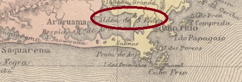
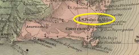
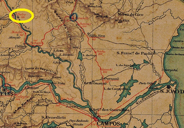
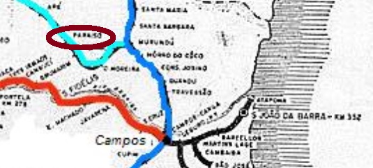
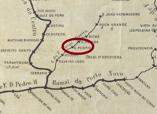
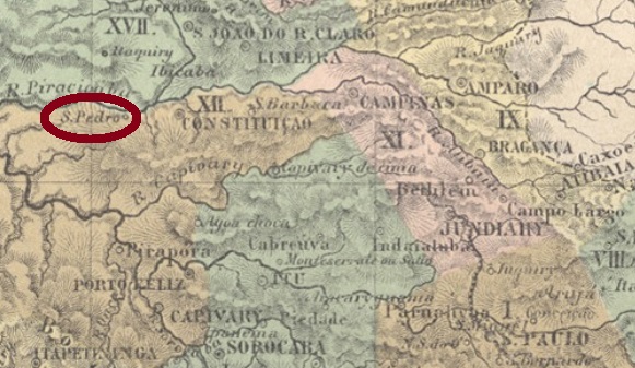
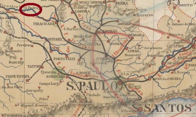
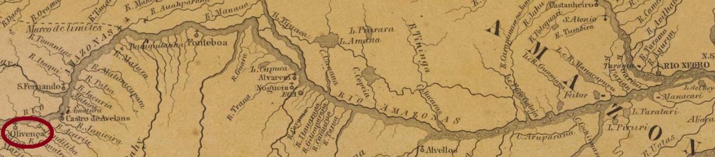
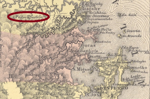
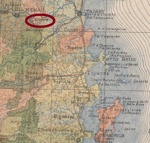
São Pedro Apóstolo do Gaspar (=Gaspar’s Apostle Peter) was the name of a freguesia near Itajahy from April 1861, situated on the south bank of the Itajaí-Açu River, barely 140 km north of the provincial capital Desterro (now Florianópolis). Gaspar was the small affluent which had its mouth on place. In February 1880, the municipality transferred as a district to the Município of Blumenau, and in February 1934 it received its political autonomy as an independent Município.

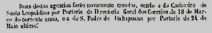
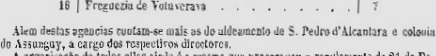
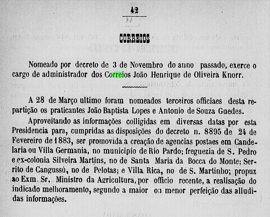
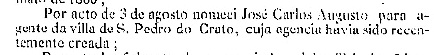
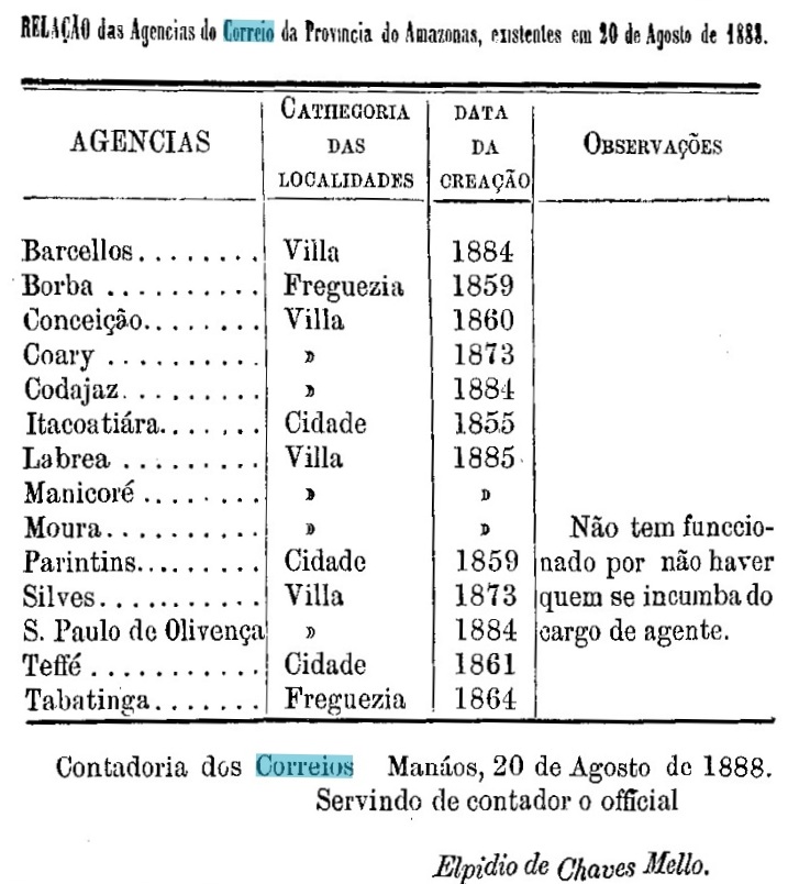
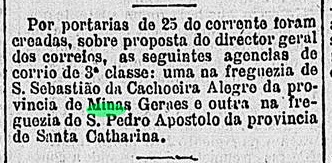
The post office there was established in April 1881, as shown in the Rio Press:

Gazeta de Noticias/RJ, 26 April 1881

The imperial postmark is SSC-0235a (Coll. Karlheinz Wittig): a double circle with the inscription S. PEDRO APOSTOLO above and an ornament in diamond below, formed by four small diamonds. Dates in the centre from 1883 to 1885.

Furthermore, another 19th century postmark has appeared after the printing of Carimbologia S2, SSC-0235b (Coll. Fuad Ferreira Fo.):

SSC-0236b (FF) 1890-1906
Carta do Estado de Santa Catharina, 1907

Aktualisierung der Printausgabe, am 11. Januar 2022

Andere Namen: São Pedro Apóstolo do Gaspar, Gaspar (1934)

São Pedro Apóstolo do Gaspar (=Gaspars Apostel Petrus) hieß ab April 1861 eine Freguesia bei Itajahy, die am Südufer des Flusses Itajaí-Açu lag, knapp 140 km nördlich der Provinzhauptstadt Desterro (heute Florianópolis) entfernt. Gaspar hieß der kleine Zufluss, der dort mündete. Im Februar 1880 wechselte die Gemeinde als Distrikt zum Município von Blumenau, und im Februar 1934 erhielt sie ihre politische Autonomie als selbständiger Município.

Das dortige Postamt entstand im April 1881, wie aus der Rio-Presse hervorging:

Gazeta de Noticias/RJ, 26. April 1881

Der kaiserliche Poststempel ist SSC-0235a (Samml. Karlheinz Wittig): ein Doppelkreis mit der Inschrift S. PEDRO APOSTOLO oben und einem Ornament in Raute unten, das aus vier kleinen Rauten gebildet wird. Daten in der Mitte von 1883 bis 1885.

Es ist aber ein weiterer Poststempel des 19. Jahrhunderts nach dem Druck der Carimbologia S2 aufgetaucht, SSC-0235b (Samml. Fuad Ferreira Fo.):

SSC-0236b (FF) 1890-1906

Categories
Carimbologia S

São Pedro da Aldeia, Rio de Janeiro (SRJ-0020)

Atlas do Imperio do Brasil, 1868

Other names: Aldeia de São Pedro, Sapiatiba.

The history of this settlement, which is very old by Brazilian standards, began as early as May 1617, when the Aldeia de São Pedro was founded on the north-eastern shore of Lake Araruama near Cabo Frio, about 140 east of the future capital Rio de Janeiro. In December 1795, it became a freguesia, which rose to become a villa called Sapiatiba in September 1890. However, the Tupi word meaning rich in clay did not find favour, and a good two years later the old place name returned. São Pedro da Aldeia has been a town since December 1929.

Again, there are two dates for the origin of the local post office. The Imperial Mail Register (Tabella das Agencias do Correio do Imperio) of 1885 gives the year 1820 for it, while Nova Monteiro (Administrações e Agencias Postaes do Brasil Imperio, in Brasil Filatelico/RJ, 1934-5; Reprint SPP 1994-1999) lists the agency from June 1829.

Both postmarks of the imperial period found so far bear the place name Aldeia de S. Pedro and should rather be discussed under letter A. Since Reinhold Koester did not do so, they are presented here. SRJ-0200a also occurs in blue, was in use from about 1829 to 1884 and was already presented by Paulo Ayres (Catálogo de Carimbos Brasil-Império, S. Paulo, 1937, 1942) under no. 1193:

SRJ-0200a (P. A. 1193)

SRJ-0200b (agenciaspostais.com.br) is a simple double circle with the inscription A. DE S. PEDRO at the top. The only known copy is dated 1884 in the centre.

Villiers de l’Ile Adam: Carta (…) da Provincia do Rio de Janeiro, 1850

Andere Namen: Aldeia de São Pedro, Sapiatiba

Die Geschichte dieser für brasilianische Verhältnisse sehr alten Siedlung fing bereits im Mai 1617 an, als die Aldeia de São Pedro am Nordostufer des Araruama-Sees bei Cabo Frio gegründet wurde, ca. 140 östlich der künftigen Hauptstadt Rio de Janeiro entfernt. Im Dezember 1795 wurde daraus eine Freguesia, die im September 1890 zu einer Villa namens Sapiatiba aufstieg. Das Tupi-Wort, das reich an Lehm bedeutet, fand jedoch kein Gefallen, und gut zwei Jahre später kam der alte Ortsname zurück. Seit Dezember 1929 ist São Pedro da Aldeia eine Stadt.

Auch hier gibt es zwei Jahresangaben für die Entstehung des örtlichen Postamts. Das Verzeichnis der kaiserlichen Postämter (Tabella das Agencias do Correio do Imperio) von 1885 nennt dafür das Jahr 1820, während Nova Monteiro (Administrações e Agencias Postaes do Brasil Imperio, in Brasil Filatelico/RJ, 1934-5; Reprint SPP 1994-1999) die Agentur ab dem Juni 1829 auflistet.

Beide bisher gefundenen Poststempel der Kaiserzeit tragen den Ortsnamen Aldeia de S. Pedro und sollten eigentlich unter Buchstabe A besprochen werden. Da Reinhold Koester dies nicht gemacht hat, werden sie hier vorgestellt. SRJ-0200a kommt auch in blau vor, war von ca. 1829 bis 1884 in Gebrauch und wurde bereits durch Paulo Ayres (Catálogo de Carimbos Brasil-Império, S. Paulo, 1937, 1942) unter Nr. 1193 vorgestellt:

SRJ-0200a (P. A. 1193)

SRJ-0200b (agenciaspostais.com.br) ist ein einfacher Doppelkreis mit der Inschrift A. DE S. PEDRO oben. Das einzige Exemplar ist 1884 in der Mitte datiert.

Categories
Carimbologia S

São Pedro de Alcantara, Espírito Santo (SES-0160)

Almanak Laemmert, 1892

Other names: S. Pedro de Alcantara do Itabapoanna, Monjardim, S. Pedro do Itabapoanna.

This village was a district of Cachoeiro do Itapemirim from November 1863, located about 200 km southwest of the provincial capital Vitória. Since its elevation to the villa of S. Pedro de Itabapoanna in July 1887, the village changed its name twice: in June 1890 to Monjardim and in March 1892 back to S. Pedro do Itabapoanna. However, things did not go as expected economically and politically, and the village became a district of Mimoso do Sul in January 1930, which is still valid today.

Two years of foundation for the local post office were found. According to the provincial president’s report in October 1878, the agency first came into being in May of that year.

Relatorio do Presidente da Provincia, October 1878

Paulo Novaes (agenciaspostais.com.br), on the other hand, write a creation date in September 1881 for it. Accordingly, the post office was closed in the meantime. The only postmark of the imperial period so far is SES-0160a (Coll. José A. Junges). A double circle with the inscription S. PEDRO DE ALCANTARA on top and an ornament in diamond below consisting of four small diamonds. The dates in the centre go from 1885 to 1891.

agenciaspostais.com.br

Andere Namen: S. Pedro de Alcantara do Itabapoanna, Monjardim, S. Pedro do Itabapoanna

Diese Ortschaft war ab November 1863 ein Distrikt von Cachoeiro do Itapemirim, der ca. 200 km südwestlich der Provinzhauptstadt Vitória entfernt lag. Seit dem Aufstieg zur Villa von S. Pedro de Itabapoanna im Juli 1887 wechselte der Ort noch zweimal den Namen: im Juni 1890 zu Monjardim und im März 1892 zurück zu S. Pedro do Itabapoanna. Allerdings ging es wirtschaftlich und politisch nicht so wie erwartet, und der Ort stieg im Januar 1930 zum Distrikt von Mimoso do Sul, was heute noch gültig ist.

Zwei Gründungsjahre fürs örtliche Postamt wurden gefunden. Laut dem Bericht des Provinzpräsidenten im Oktober 1878 entstand die Agentur erstmals im Mai des Jahres:

Relatorio do Presidente da Provincia, Oktober 1878

Dafür schreibt Paulo Novaes (agenciaspostais.com.br) den September 1881 für diese Entstehung. Demnach war das Postamt zwischendurch geschlossen. Der bisher einzige Poststempel der Kaiserzeit ist SES-0160a (Samml. José A. Junges). Ein Doppelkreis mit der Inschrift S. PEDRO DE ALCANTARA oben und ein Ornament in Raute unten, das aus vier kleinen Rauten besteht. Die Daten in der Mitte gehen von 1885 bis 1891.

Categories
Carimbologia S

São Pedro d’Alcantara, Paraná (SPR-0203)

Mappa Geral da Provincia do Paraná, 1876

This is another locality that has disappeared from the map today. Its history began in 1855, when an Indian settlement was founded on the west bank of the Tibagy River near Castro, more than 400 km northwest of the provincial capital of Curitiba. When the villa of Tibagy was built in 1872, the place went to the Freguesia of Conceição do Jatahy, which belonged to it. The settlement project ended in 1895 and it is not known what became of the Indians. The village grew very slowly and in October 1938 it became part of the newly created Município of Sertanópolis as the district of Ibiporã. Since October 1947, it has been a suburb of the town of Ibiporã. The word from the Tupi-Guarani language means Beautiful Land.

The earliest mention of a local post office was found in the provincial president’s report for February 1868:

Relatório do Presidente da Provincia/PR, February 1868.

Since a postal route from Tibagy to S. Pedro d’Alcantara had already been active a year earlier (Dezenove de Dezembro, 7 August 1867), one may assume that the post office had been established shortly before. However, the 1880 Imperial Postal Guide (Guia Postal do Império) does not list the agency. It is likely that a chickenpox epidemic in 1878 caused the cessation of postal operations. No postmark has yet been found from there. With a population of 294 (1879), this postmark must be very rare.

Mappa do Estado do Paraná, 1896

Diese ist wieder eine Ortschaft, die heute von der Landkarte verschwunden ist. Ihre Geschichte fing 1855 an, als eine Indianersiedlung am Westufer des Flusses Tibagy bei Castro gegründet wurde, über 400 km nordwestlich der Provinzhauptstadt Curitiba entfernt. Als 1872 die Villa von Tibagy entstanden ist, ging der Ort zur dazu gehörenden Freguesia von Conceição do Jatahy. Das Siedlungsprojekt wurde 1895 beendet, und man weiß nicht, was aus den Indianern wurde. Die Ortschaft wuchs sehr langsam und ging im Oktober 1938 als Distrikt von Ibiporã zum neu gegründeten Município von Sertanópolis. Seit Oktober 1947 ist es ein Vorort des Städtchens Ibiporã. Das Wort aus der Tupi-Guarani-Sprache bedeutet Schönes Land.

Die früheste Erwähnung eines Postamtes vor Ort findet man im Bericht des Provinzpräsidenten für Februar 1868:

Relatório do Presidente da Provincia/PR, Februar 1868

Da schon ein Jahr zuvor eine Postroute von Tibagy zu S. Pedro d’Alcantara aktiv war (Dezenove de Dezembro, 7. August 1867), darf man annehmen, dass das Postamt kurz davor entstanden war. Im kaiserlichen Postführer (Guia Postal do Império) von 1880 wird die Agentur allerdings nicht aufgelistet. Wahrscheinlich hat eine Windpockenepidemie 1878 die Einstellung des Postbetriebs verursacht. Kein Poststempel wurde bisher von dort gefunden. Bei einer Bevölkerungszahl von 294 (1879) muss dieser Stempel sehr selten sein.

Categories
Carimbologia S

São Pedro (train station/Bahnhof), Rio de Janeiro (SRJ-1863)

Almanak Laemmert 1892

This station was inaugurated in June 1880 by the E. F. Carangola Railway Company in the municipality of Campos dos Goytacazes and was located on the north bank of the Muriaé River, about 320 km northeast of the capital Rio de Janeiro. The railway line changed hands three times: in 1890 to the Cia. Barão de Araruama and then to the Estrada de Ferro Leopoldina, in 1975 to the Rede Ferroviária Federal. The railway ceased to operate in 1977, the rails have since disappeared, and the station building was last used as a Baptist church hall (estacoesferroviarias.com.br).

In 2006 (Photo: Lucio Fernandes, in estacoesferroviarias.com.br)

The station was renamed Paraiso in 1892; around it grew a settlement, now the district of Paraíso, in the Município of Italva. This municipality first became a município in 1983. Nevertheless, due to a formal error, this administrative autonomy was soon revoked and only restored in 1986.

According to the Imperial Mail Register (Tabella das Agencias do Correio do Imperio, 1885), there was a station post office since 1880. Two postmarks in double circle were found. SRJ-1893a (Coll. José A. Junges) has the inscription E. DE S. PEDRO; the only existing specimen bears a date from 1883 in the centre. SRJ-1893b (coll. Klerman W. Lopes) now has the inscription EST. DE S. PEDRO at the top and E.F. DO CARANGOLA at the bottom. Two copies dated 1889 at the centre.

E.F. Leopoldina

Dieser Bahnhof wurde im Juni 1880 durch die E. F. Carangola Bahngesellschaft im Município von Campos dos Goytacazes eingeweiht und lag am Nordufer des Flusses Muriaé, gut 320 km nordöstlich der Hauptstadt Rio de Janeiro entfernt. Die Bahnlinie wechselte den Besitzer dreimal: 1890 zu der Cia. Barão de Araruama und gleich danach zur Estrada de Ferro Leopoldina, und 1975 zur Rede Ferroviária Federal. Der Bahnbetrieb wurde 1977 eingestellt, die Schienen sind inzwischen weg, und das Bahnhofsgebäude diente zuletzt als Kirchraum der Baptisten (estacoesferroviarias.com.br).

2006 (Foto: Lucio Fernandes, in estacoesferroviarias.com.br)

Der Bahnhof wurde 1892 zu Paraiso umbenannt; um ihn herum wuchs eine Siedlung, die heute der Distrikt von Paraíso ist, im Município von Italva. Diese Gemeinde wurde erstmals 1983 ein Município. Durch einen Formfehler wurde dennoch diese Verwaltungsautonomie bald aufgehoben und erst 1986 wiederhergestellt.

Laut Verzeichnis der kaiserlichen Postämter (Tabella das Agencias do Correio do Imperio, 1885) gab es ein Bahnhofspostamt seit 1880. Zwei Poststempel in Doppelkreis wurden gefunden. SRJ-1893a (Samml. José A. Junges) hat die Inschrift E. DE S. PEDRO; das einzige vorhandene Exemplar trägt ein Datum aus 1883 in der Mitte. SRJ-1893b (Samml. Klerman W. Lopes) hat nun oben die Inschrift EST. DE S. PEDRO und unten E.F. DO CARANGOLA. Zwei Exemplare, datiert 1889 in der Mitte.

Categories
Carimbologia S

São Pedro (train station/Bahnhof), Minas Gerais (SMG-2545)

Mappa das Estações de São Paulo, Rio de Janeiro e Minas Geraes, 1880

Another name: Pequery (Estação).

This station was inaugurated in July 1879 by the E.F. União Mineira railway company and was located on the Caratinga Line near Juiz de Fora, just under 280 km south of the provincial capital Ouro Preto. In 1884, the railway line was transferred to the Estrada de Ferro Leopoldina, and from 1975 until the end of operations in 1994, it belonged to Rede Ferroviária Federal. In the 1940s, the name changed to Pequeri, a word in the Tupi language that is said to mean River of the Little Fish. Now the rails have been torn out and the station building has become a small bistro.

In 2008 (Photo: Jorge A. Ferreira, from estacoesferroviarias.com.br)

Paula Sobrinho writes in História Postal de Minas Gerais (Belo Horizonte, 1997) that there has been a station post office since July 1877. This is probably a typo, as this date is two years before the inauguration of the station. Two 19th century double-circle postmarks were found. SMG-2545a (coll. Karlheinz Wittig) has the inscription S. PEDRO (ESTAÇÃO) at the top, dated inside from 1883 to 1889. SMG-2545b (coll. José A. Junges) now has EST. DE S. PEDRO above and at the bottom it reads (MINAS). Dates in the middle: 1890-1899.

IBGE (apud estacoesferroviarias.com.br)

Anderer Name: Pequery (Estação)

Dieser Bahnhof wurde im Juli1879 durch die E.F. União Mineira Bahngesellschaft eingeweiht und lag auf der Caratinga-Linie bei Juiz de Fora, knapp 280 km südlich der Provinzhauptstadt Ouro Preto entfernt. 1884 ging die Bahnlinie zur Estrada de Ferro Leopoldina über, und von 1975 bis Betreibsende 1994 gehörte sie der Rede Ferroviária Federal. In den 40er Jahren wechselte der Name zu Pequeri, ein Wort der Tupi-Sprache, das Fluss der Fischlein bedeuten soll. Nun sind die Schienen ausgerissen, aus dem Bahnhofsgebäude wurde ein kleines Bistro.

In 2008 (Foto: Jorge A. Ferreira, aus estacoesferroviarias.com.br)

Paula Sobrinho schreibt in História Postal de Minas Gerais (Belo Horizonte, 1997), dass es dort seit Juli 1877 ein Postamt gibt. Das dürfte ein Tippfehler sein, denn dieses Datum liegt zwei Jahre vor der Bahnhofseinweihung. Zwei Poststempel im Doppelkreis aus dem 19. Jahrhundert wurden gefunden. SMG-2545a (Samml. Karlheinz Wittig) hat die Inschrift S. PEDRO (ESTAÇÃO) oben, datiert im Inneren von 1883 bis 1889. Bei SMG-2545b (Samml. José A. Junges) heißt es nun oben EST. DE S. PEDRO und unten liest man (MINAS). Daten in der Mitte: 1890-1899.

Categories
Carimbologia S

São Pedro, São Paulo (SSP-1215)

Atlas do Imperio do Brasil, 1868

This locality was a district near Piracicaba from April 1864, located close to the north bank of the Piracicaba River, barely 200 km northwest of the provincial capital of São Paulo. It rose to the status of a villa in February 1881 and to a town in October 1903.

The local post office was established in April 1874, as can be read in the regional press:

Correio Paulistano, 21 April 1874

So far, only SSP-1215a (Klerman Lopes Collection) could be found as an imperial postmark: a “French type”, with the inscription SÃO PEDRO above and the star between brackets below. It is said to occur in black and blue, the only seen specimen has a date from the beginning of the 1980s.

Provincia de São Paulo, 1886

Diese Ortschaft war ab April 1864 ein Distrikt bei Piracicaba, der nah am Nordufer des Flusses Piracicaba lag, knapp 200 km nordwestlich der Provinzhauptstadt São Paulo entfernt. Im Februar 1881 steig sie zur Villa und im Oktober 1903 zur Stadt auf.

Das örtliche Postamt entstand im April 1874, wie man in der Regionalpresse lesen kann:

Correio Paulistano, 21. April 1874

Bisher konnte nur SSP-1215a (Samml. Klerman Lopes) als kaiserlicher Poststempel gefunden werden: ein „Französischer Typus“, mit der Inschrift SÃO PEDRO oben und dem Stern zwischen Klammern unten. Er soll in schwarz und blau vorkommen, das einzige Exemplar hat ein Datum vom Anfang der 80er Jahre.

Categories
Carimbologia S

São Pedro, Rio Grande do Sul (SRS-0367)

Atlas do Imperio do Brasil

Other names: Rincão de São Pedro, São Pedro do Sul (1944)

This small village can easily be confused with the province of the same name, but it was not elevated to a district in the municipality of Santa Maria until June 1882. It was located about 330 km west of the provincial capital Porto Alegre. In December 1944, the locality rose to a municipality and was given the name São Pedro do Sul, which is still in use today.

The local post office was established in about 1887, as can be seen from the provincial president’s report of April of that year:

Relatório do Presidente da Provincia, April 1887

So far, no postmark of the imperial period could be assigned to this municipality with certainty.

Provincia de São Pedro do Rio Grande do Sul, 1877

Andere Namen: Rincão de São Pedro, São Pedro do Sul (1944)

Diese kleine Ortschaft kann leicht mit der gleichnamigen Provinz verwechselt werden, ist aber erst im Juni 1882 zum Distrikt im Município von Santa Maria erhoben worden und lag ca. 330 km westlich der Provinzhauptstadt Porto Alegre. Im Dezember 1944 steig der Ort zum Município auf und bekam den heute noch aktuellen Namen São Pedro do Sul.

Das örtliche Postamt ca. 1887 entstanden, wie aus dem Bericht des Provinzpräsidenten vom April d. J. hervorgeht:

Relatório do Presidente da Provincia, April 1887

Bisher konnte kein Poststempel der Kaiserzeit dieser Gemeinde mit Sicherheit zugeordnet werden.

Categories
Carimbologia S

São Pedro, Ceará (SCE-0300)

Atlas do Imperio do Brasil, 1868

Other names: São José, Serra de S. Pedro do Crato, S. Pedro do Cariri, Caririaçu (1943).

This locality has a long and turbulent history, due to unfavourable climatic and economic conditions. It began with the creation of the district of São José in the municipality of Crato in May 1859, almost 500 km south of the provincial capital Fortaleza. In September 1873, this became the district of Serra de São Pedro, which was elevated to villa status in August 1876. Three years later, however, it was demoted to the district of S. José da Serra de S. Pedro in the municipality of Joazeiro, only to rise again to villa status in November 1883, this time under the name of São Pedro do Crato. The next demotion followed in July 1900, this time as a district in the municipality of Crato, and August 1905 came the final arousal to Villa of Serra de S. Pedro do Crato. Thereafter, this município changed the name twice: in August 1918 to S. Pedro do Cariri and in December 1943 to the current Caririaçu.

As stated by the Provincial President’s report in April 1888, there has been a post office there since 1887:

Relatório do Presidente da Provincia, April 1888.

The only 19th century postmark surely identified for this locality so far, SCE-0300a, was presented by Cícero Antonio Almeida in Carimbos Postais – século XIX (Rio de Janeiro, 1989) under no. MPT 787.

SCE-0300a (MPT 787, op. cit.)
Serviço Geológico e Mineralógico do Brasil, 1910

Andere Namen: São José, Serra de S. Pedro do Crato, S. Pedro do Cariri, Caririaçu (1943)

Diese Ortschaft hat eine lange und bewegte Geschichte, bedingt durch ungünstige klimatische und wirtschaftliche Verhältnisse. Den Beginn machte die Gründung des Distrikts São José im Município von Crato im Mai 1859, fast 500 km südlich der Provinzhauptstadt Fortaleza entfernt. Im September 1873 wurde daraus der Distrikt von Serra de São Pedro, der im August 1876 zur Villa erhoben wurde. Drei Jahre später jedoch wurde der Ort zum Distrikt S. José da Serra de S. Pedro im Município von Joazeiro degradiert, um im November 1883 wieder zur Villa aufzusteigen, diesmal unter dem Namen São Pedro do Crato. Im Juli 1900 folgte der nächste Abstieg, diesmal als Distrikt im Município von Crato, und August 1905 kam der endgültige Aufstieg zur Villa von Serra de S. Pedro do Crato. Danach wechselte dieser Município zweimal den Namen: im August 1918 zu S. Pedro do Cariri und im Dezember 1943 zum aktuellen Caririaçu.

Wie der Bericht des Provinzpräsidenten im April 1888 besagt, gibt es dort ein Postamt seit 1887:

Relatório do Presidente da Provincia, April 1888

Der einzige, bisher sicher identifizierte Poststempel im 19. Jahrhundert für diese Ortschaft, SCE-0300a, wurde durch Cícero Antonio Almeida in Carimbos Postais – século XIX, (Rio de Janeiro, 1989) unter Nr. MPT 787 präsentiert.

SCE-0300a (MPT 787, op. cit.)

Categories
Carimbologia S

São Paulo de Olivença, Amazonas (SAM-0085)

Atlas do Imperio do Brasil, 1868

Other names: Javary, Olivença

See also Olivença (R. Koester: Carimbologia XXIX)

São Paulo de Olivença was already in the mid-18th century a freguesia in the Capitania of Grão-Pará, located on the south bank of the Amazon (the river is already called Solimões there), almost 1,000 km west of the future provincial capital Manaus. In 1833, it became a district called Javary in the municipality of Teffé, which was then elevated to a villa in May 1882.

As can be read in the Provincial President’s Report for 1888, there was a post office there already in 1884:

Relatorio do Presidente da Provincia, 1888

So far, no Imperial postmark has been found from this locality.

Villiers de l’Ile Adam: Carta (…) das Provincias de Gram Pará e Alto Amazonas, 1850

Andere Namen: Javary, Olivença

Siehe auch Olivença (R. Koester: Carimbologia XXIX)

São Paulo de Olivença war bereits Mitte des 18. Jahrhunderts eine Freguesia in der Capitania von Grão-Pará, die am Südufer des Amazonas (der Fluss heißt dort eigentlich Solimões) lag, fast 1.000 km westlich der künftigen Provinzhauptstadt Manaus entfernt. In 1833 wurde daraus ein Distrikt namens Javary im Município von Teffé, der dann im Mai 1882 zur Villa erhoben wurde.

Wie im Bericht des Provinzpräsidenten für 1888 zu lesen ist, gibt es dort bereits 1884 ein Postamt:

Relatorio do Presidente da Provincia, 1888

Bisher wurde kein Poststempel des Kaiserreichs aus dieser Ortschaft gefunden.