Categories
Carimbologia S

São Luiz (train station/Bahnhof), Minas Gerais (SMG-2510)

Estações (…) do Rio de Janeiro, São Paulo e Minas Geraes, 1880

Another name: Trimonte (1943)

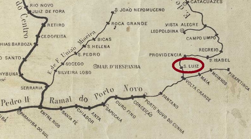
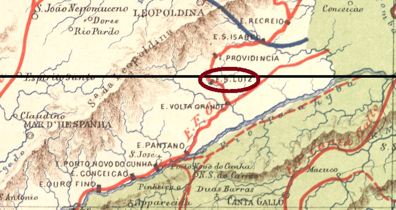
The São Luiz station was opened in July 1874 by the Estrada de Ferro Leopoldina Railway Company (Main Line) in the municipality of Mar d’Hespanha, 280 km southeast of the provincial capital Ouro Preto. From 1975 until the end of 1996, the railway line belonged to the Rede Ferroviária Federal S.A. Today the station building is neglected, children occasionally play football in the empty hall (estacoesferroviarias.com.br).

In 2008. Photo Gutierrez L. Coelho (estacoesferroviarias.com.br)

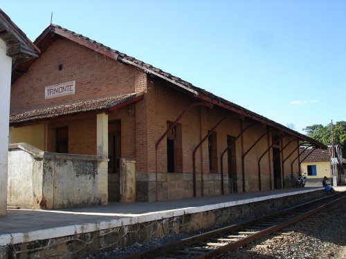
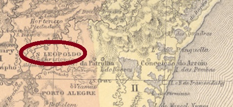
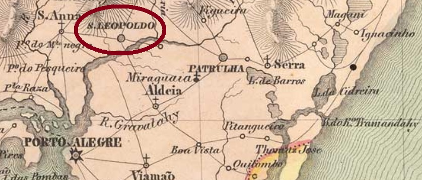
The settlement around the station kept growing and in August 1890 became a district, now in the municipality of São José d’Além Parahyba. From December 1938, the district changed to the newly founded municipality of Volta Grande, and five years later both district and railway station were renamed Trimonte.

Two dates of origin were found for the station post office. First in July 1875, as can be read in Paula Sobrinho’s Historia Postal de Minas Gerais (Belo Horizonte, 1997) and in the Imperial Mail Register (Tabella das Agencias do Correio do Imperio) of 1885. The second date would be exactly 6 years later and was also recorded by Paula Sobrinho and confirmed by the Postal Report for 1887. Apparently, the station post office was closed in between.

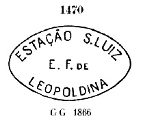
Two postmarks and a mute cancel are known for this railway station in the Empire. The first cancel, SMG-2510a, was in use probably from the beginning, having been already shown by Paulo Ayres (Catalogo de Carimbos Brasil-Império, S. Paulo, 1937, 1942) under No. 1470:

SMG-2510a (P.A. 1470) 1875ff

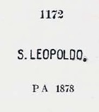
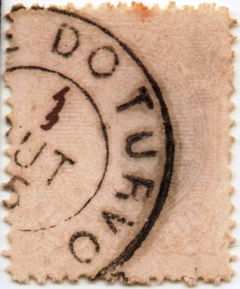
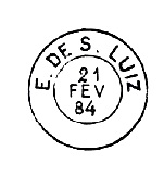
It was followed by SMG-2510b, which was found with dates from 1883 to 1889 and was also depicted in P. Ayres on p. 125:

SMG-2510b (P.A. p/S. 125)

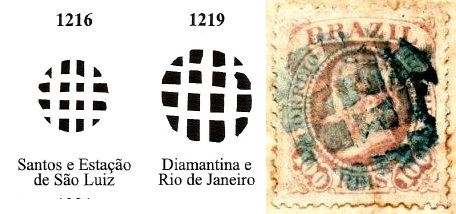
The mute cancel was found on a letter from 1883 (image from the Internet) together with SMG-2510b. According to James A. Dingler/Klerman W. Lopes (Mute Cancellations of the Brazil Empire/ Carimbos Mudos do Brasil Império, Brazil Philatelic Association, Rio de Janeiro, 2000) it would be No. 1216. However, it looks more like No. 1219:

BPA 1216 and 1219 (1883)

Estrada de Ferro Central do Brasil, 1890

Anderer Name: Trimonte (1943)

Der Bahnhof São Luiz wurde im Juli 1874 durch die Estrada de Ferro Leopoldina Eisenbahngesellschaft (Hauptlinie) eingeweiht und lag im Município von Mar d’Hespanha, 280 km südöstlich der Provinzhauptstadt Ouro Preto entfernt. Von 1975 bis Betriebsende 1996 gehörte die Bahnlinie der Rede Ferroviária Federal S.A. Heute ist das Bahnhofsgebäude verwahrlost, Kinder spielen gelegentlich Fußball in der leeren Halle (estacoesferroviarias.com.br).

In 2008: Foto Gutierrez L. Coelho (estacoesferroviarias.com.br)

Die Siedlung um den Bahnhof wuchs weiter und wurde im August 1890 zum Distrikt, nun im Municipio von São José d’Além Parahyba. Ab Dezember 1938 ging der Ort zum neu gegründeten Município von Volta Grande, und fünf Jahre später wurden Distrikt und Bahnhof zu Trimonte umbenannt.

Zwei Entstehungsdaten wurden fürs Bahnhofspostamt gefunden. Erstmals im Juli 1875, wie sowohl bei Paula Sobrinho (Historia Postal de Minas Gerais, Belo Horizonte, 1997) als auch im Verzeichnis der kaiserlichen Postämter (Tabella das Agencias do Correio do Imperio, Rio) von 1885 zu lesen ist. Das zweite Datum wäre exakt 6 Jahre später und wurde ebenfalls von Paula Sobrinho notiert und vom Postbericht für 1887 bestätigt. Scheinbar war das Bahnhofspostamt zwischendurch geschlossen.

Zwei Poststempel und eine stumme Entwertung sind für diese Bahnstation im Kaiserreich vorhanden. Der erste Stempel SMG-2510a war in Gebrauch wohl von Anfang an und wurde bereits durch Paulo Ayres (Catálogo de Carimbos Brasil-Império, S. Paulo, 1937, 1942) unter Nr. 1470 gezeigt:

SMG-2510a (P.A. 1470) 1875ff

Ihm folgte SMG-2510b, der mit Daten von 1883 bis 1889 gefunden wurde und ebenfalls im P. Ayres auf S. 125 abgebildet wurde:

SMG-2510b (P.A. pg/S. 125)

Der stumme Stempel wurde auf einem Brief von 1883 (Abb. aus dem Internet) zusammen mit SMG-2510b gesehen. Laut James A. Dingler/Klerman W. Lopes (Mute Cancellations of the Brazil Empire/ Carimbos Mudos do Brasil Império, Brazil Philatelic Association, Rio de Janeiro, 2000) wäre er Nr. 1216. Allerdings sieht er eher nach Nr. 1219 aus :

BPA 1216 und 1219 (1883)

Categories
Carimbologia S

São Lourenço (da Matta), Pernambuco (SPE-0565)

Atlas do Imperio do Brasil, 1868

In the 18th century, this locality was already a settlement near Recife, situated on the north bank of the Capibaribe River, 20 km west of the provincial capital. In the 19th century it became a freguesia, in June 1884 an independent villa and in July 1909 a town, simply called São Lourenço between 1938 and 1943.

Three dates of origin for the local post office have been identified. First, the Imperial Postal Report (Relatório Postal) for 1860 mentions 1854. Then Nova Monteiro in Administrações e Agencias Postaes do Brasil Imperio (Brasil Filatelico/RJ, 1934-5; Reprint SPP 1994-1999) writes January 1855. The agency was already closed around 1858, as shown in the February 1859 report of the General Postal Directory (Directoria Geral dos Correios):

Relatorio da Directoria Geral dos Correios, February 1859.

Later on, the Imperial Mail Register (Tabella das Agencias do Correio do Imperio) of 1885 listed this agency as of 1873. A postmark was found from this last period of operation. SPE-0565b (Coll. José A. Junges) is a French type: a small double circle with the inscription S. LOURENÇO above and the typical star between brackets below. The centre was blank; the date was to be written by hand, which did not always happen. Found from about 1884 to 1886.

Villiers de l’Ile Adam: Carta (…) das Provincias de Pernambuco, Alagoas e Sergipe, 1847

Anderer Name: São Lourenço (1938-1943)

Diese Ortschaft war bereits im 18. Jahrhundert eine Siedlung bei Recife, die am Nordufer des Flusses Capibaribe lag, 20 km westlich der Provinzhauptstadt entfernt. Im 19. Jahrhundert wurde sie eine Freguesia, im Juni 1884 eine eigenständige Villa und im Juli 1909 eine Stadt, die zwischen 1938 und 1943 einfach São Lourenço hieß.

Drei Entstehungsdaten für das örtliche Postamt wurden ermittelt. Zuerst erwähnt der kaiserliche Postbericht (Relatório Postal) für 1860 das Jahr 1854. Dann schreibt Nova Monteiro in Administrações e Agencias Postaes do Brasil Imperio (Brasil Filatelico/RJ, 1934-5; Reprint SPP 1994-1999) den Januar 1855. Die Agentur wurde um 1858 bereits geschlossen, wie aus dem Bericht der Allgemeinen Postdirektion (Directoria Geral dos Correios) vom Februar 1859 hervorgeht:

Relatorio da Directoria Geral dos Correios, Februar 1859

Zuletzt listet das Verzeichnis der kaiserlichen Postämter (Tabella das Agencias do Correio do Imperio) von 1885 diese Agentur ab 1873 auf. Ein Poststempel wurde aus dieser letzten Betriebszeit gefunden. SPE-0565b (Samml. José A. Junges) ist ein Französischer-Typus: ein kleiner Doppelkreis mit der Inschrift S. LOURENÇO oben und dem typischen Stern zwischen Klammern unten. Die Mitte war frei; das Datum sollte per Hand geschrieben werden, was nicht immer geschah. Gefunden von ca. 1884 bis 1886.

Categories
Carimbologia S

São Lourenço do Manhuassú, Minas Gerais (SMG-2505)

Carta da Republica dos Estados Unidos do Brazil, 1892

Another name: Manhuassú (1881)

See also Manhuassú (R. Koester: Carimbologia XXVII)

From November 1875 this was a freguesia of Ponte Nova, which was located about 200 east of the provincial capital Ouro Preto. In November 1877, it was transferred as a district to the municipality of São Simão, and in January 1880 it became the administrative headquarters. Since September 1881, it has been the town of Manhuassú (now written Manhuaçu). The Manhuaçu is a tributary of the Rio Doce; its Indian name means Big Rain. 

As Paula Sobrinho writes in Historia Postal de Minas Gerais (Belo Horizonte, 1997), the local post office was created in September 1880. The postmark of the Imperial period is the double circle SMG-2505a (Coll. José A. Junges): the inscription above is S. LOURENÇO DO MANHUASSÚ. There is an ornament in diamond below, the four sides of which are open. Dates inside from 1885 to 1889.

Mappa de Minas Geraes, 1910

Anderer Name: Manhuassú (1881)

Siehe auch Manhuassu (R. Koester: Carimbologia XXVII)

Diese war ab November 1875 eine Freguesia von Ponte Nova, die gut 200 östlich der Provinzhauptstadt Ouro Preto entfernt lag. Im November 1877 ging sie als Distrikt zum Município von São Simão über und wurde im Januar 1880 Verwaltungshauptsitz. Seit September 1881 ist es die Stadt Manhuassú (heute Manhuaçu geschrieben). Der Manhuaçu ist ein Zufluss des Rio Doce; sein indianischer Name bedeutet Große Regen.  

Wie Paula Sobrinho in História Postal de Minas Gerais (Belo Horizonte, 1997) schreibt, entstand das Postamt im September 1880. Der Poststempel der Kaiserzeit ist der Doppelkreis SMG-2505a (Samml. José A. Junges): die Inschrift oben lautet S. LOURENÇO DO MANHUASSÚ. Unten steht ein Ornament in Raute, deren vier Seiten offen sind. Daten im Inneren von 1885 bis 1889.

Categories
Carimbologia S

São Lourenço, Rio Grande do Sul (SRS-0350)

Mappa da Provincia de São Pedro do Rio Grande do Sul, 1877

Other name: São Lourenço do Sul (1944)

This was a colony of German immigrants, established in 1858 in the district of S. João da Reserva on the west bank of the Lagoa dos Patos near Pelotas, 200 km south of the provincial capital Porto Alegre. The settlement grew faster than the superior freguesia, and when it was elevated to a villa in February 1890, the headquarters were moved to São Lourenço, which since December 1944 bears the addition “do Sul” in the place name. 

The local post office was established in October 1882, as reported by the Rio press:

Gazeta de Noticias/RJ, 22 October 1882

Two early local cancels with double circle were found. SRS-0350a (Coll. José A. Junges) was seen only once in purple and has above the inscription COLONIA DE S. LOURENÇO, with inner date from 1884. SRS-0350b (image from the Internet) will probably be Republican. Here the inscription above is V. DE S. LOURENÇO, and below you can read (S. P. DO SUL). Dates inside from 1897 to 1906.

Carta da Republica dos Estados Unidos do Brazil, 1892

Anderer Name: São Lourenço do Sul (1944)

São Lourenço war eine Kolonie von deutschen Einwanderern, die 1858 im Distrikt von S. João da Reserva am Westufer der Lagoa dos Patos bei Pelotas lag, 200 km südlich der Provinzhauptstadt Porto Alegre entfernt. Die Siedlung wuchs rascher als die übergeordnete Freguesia, und als diese im Februar 1890 zur Villa erhoben wurde, verlegte man den Hauptsitz zu São Lourenço, der seit Dezember 1944 den Zusatz „do Sul“ im Ortsnamen trägt.  

Das örtliche Postamt wurde im Oktober 1882 ins Leben gerufen, wie die Presse aus Rio berichtet:

Gazeta de Noticias/RJ, 22. Oktober 1882

Zwei frühe Ortsstempel im Doppelkreis wurden gefunden. SRS-0350a (Samml. José A. Junges) wurde nur einmal in violett gesehen und hat oben die Inschrift COLONIA DE S. LOURENÇO, mit Datum aus 1884. SRS-0350b (Abb. aus dem Internet) wird wohl republikanisch sein. Hier lautet die Inschrift oben V. DE S. LOURENÇO, und unten liest man (S. P. DO SUL). Daten in Inneren von 1897 bis 1906.

Categories
Carimbologia S

São Leopoldo, Rio Grande do Sul (SRS-0345)

Atlas do Imperio do Brasil, 1868

São Leopoldo in the São Pedro province was the arrival spot of the first German colonists in 1824 and played an important role in German immigration to Brazil. The village was located about 35 km north of the provincial capital Porto Alegre, became a freguesia in February 1830 and a villa in April 1846.

According to Nova Monteiro (Administrações e Agencias Postaes do Brasil Imperio, in Brasil Filatelico/RJ, 1934-5; Reprint SPP 1994-1999) there is a post office there since August 1854. This is confirmed by Aureo G. Santos in Agências de Correio Criadas e Suprimidas 1851, 1855, 1856 e 1857 (in Brasil Filatélico 181, Rio de Janeiro, 1977), although his given date of creation is 10 days earlier:

Aureo G. Santos (op. cit.)

Three early postmarks were found. The oldest of these is SRS-0345a, which was probably in use from the beginning until at least 1878 and was already introduced by Paulo Ayres in Catálogo de Carimbos Brasil-Império, (S. Paulo, 1937, 1942) under no. 1172:

SRS-0345a (P.A. 1172)

It was followed by the French-type SRS-0345b (image from the Internet): a small double circle with the inscription SAŌ LEOPOLDO above and the star in brackets below. Dates inside from about 1878 to 1889. The last cancel in the 19th century is SRS-0345c (Coll. José L. Fevereiro), which also exists in lilac: in the double circle the inscription is now S. LEOPOLDO, below there is an X-shaped ornament, formed by four small branches. Dates inside between 1890 until at least 1918.

Villiers de l’Ile Adam: Carta (…) da Provincia de São Pedro do Sul, 1847

São Leopoldo war der Ankunftsort der ersten deutschen Kolonisten in 1824 und spielt eine wichtige Rolle bei der deutschen Einwanderung in Brasilien. Der Ort lag ca. 35 km nördlich der Provinzhauptstadt Porto Alegre, wurde im Februar 1830 zu einer Freguesia und im April 1846 zu einer Villa.

Laut Nova Monteiro (Administrações e Agencias Postaes do Brasil Imperio, in Brasil Filatelico/RJ, 1934-5; Reprint SPP 1994-1999) gibt es dort ein Postamt seit August 1854. Dies wird durch Aureo G. Santos in Agências de Correio Criadas e Suprimidas 1851, 1855, 1856 e 1857 (in Brasil Filatélico 181, Rio de Janeiro, 1977) bestätigt, wenngleich das Entstehungsdatum bei ihm 10 Tage früher liegt:

Aureo G. Santos (op. cit.)

Drei frühe Poststempel wurden gefunden. Der älteste davon ist SRS-0345a, der wohl vom Anfang an bis mindestens 1878 in Gebrauch war und bereits durch Paulo Ayres in Catálogo de Carimbos Brasil-Império, (S. Paulo, 1937, 1942) unter der Nr. 1172 vorgestellt wurde:

SRS-0345a (P.A. 1172)

Ihm folgte der Französischer-Typus SRS-0345b (Abb. aus dem Internet): ein kleiner Doppelkreis mit der Inschrift SAŌ LEOPOLDO oben und dem Stern in Klammern unten. Daten in Inneren von ca. 1878 bis 1889. Der letzte Stempel im 19. Jahrhundert ist SRS-0345c (Samml. José L. Fevereiro), den es auch in violett gibt: im Doppelkreis lautet die Inschrift nun S. LEOPOLDO, unten gibt es ein X-förmiges Ornament, durch vier kleine Zweige gebildet. Daten in Inneren von 1890 bis mindestens 1918.

Categories
Carimbologia S

São Julião (train station/Bahnhof), Minas Gerais (SMG-2500)

Estrada de Ferro Central do Brasil, 1890

In July 1887, the Estrada de Ferro D. Pedro II railway company, Ponte Nova junction, inaugurated this station in the municipality of Ouro Preto, which was located about 45 km west of the provincial capital. The railway line passed to the E. F. Central do Brasil in 1889 and belonged to the Rede Ferroviária Federal S.A. from 1975 until operation end in 1996. Allegedly, the station building was renovated in 2012 to create a cultural centre (estacoesferroviarias.com.br). However, recent images cast doubt on whether this measure ever took place:

Photo: Paulo César Roman, 2020 (CC BY-SA 2.0)

Around the station grew a settlement, which was elevated to a district in August 1911. Since the end of the 19th century, the village experienced an economic boom due to the construction of a modern iron foundry (Fundição Wigg) in September 1893. The station and the district were renamed Miguel Burnier around 1892 and 1948 repectively, after a former director of the D. Pedro II railway company. The iron foundry remained in operation until 1969, when it was bought and closed by the Votorantim Company. There followed an economic decline of the village, which around 2010 had just over 800 inhabitants:

The old post office in 2020 (Photo: Paulo César Roman)

As Paula Sobrinho writes in Historia Postal de Minas Gerais (Belo Horizonte, 1997), the local post office was created in February 1888. This is confirmed by the Rio press:

Gazeta Nacional/RJ, 17 February 1888

The imperial cancel of the station is SMG-2500a (image from the Internet): a double circle with the inscriptions E. DE S. JULIÃO (with a hanging tilde between A and O) above and (MINAS) below. One copy found, dated 1889 inside.

Mappa de Minas Geraes, 1910

São Julião (train station/Bahnhof), Minas Gerais (SMG-2500)

Der Bahnhof São Julião (Sankt Julian) wurde im Juli 1887 von der Estrada de Ferro D. Pedro II Eisenbahngesellschaft, Ponte Nova-Abzweigung, im Município von Ouro Preto eingeweiht und lag knapp 45 km westlich der Provinzhauptstadt. Die Bahnlinie ging 1889 zur E. F. Central do Brasil über und gehörte von 1975 bis Betriebsende 1996 der Rede Ferroviária Federal S.A. Angeblich wurde das Bahnhofgebäude 2012 renoviert, um fortan als Kulturzentrum zu fungieren (estacoesferroviarias.com.br). Neuere Bilder lassen allerdings Zweifel aufkommen, ob diese Maßnahme tatsächlich stattfand:

Foto: Paulo César Roman, 2020 (CC BY-SA 2.0)

Rund um den Bahnhof wuchs eine Siedlung, die im August 1911 zum Distrikt erhoben wurde. Seit dem Ende des 19. Jahrhunderts erlebte der Ort einen wirtschaftlichen Aufschwung, bedingt durch den Bau einer modernen Eisengießerei (Fundição Wigg) im September 1893. Der Bahnhof und der Distrikt wurden um 1892 bzw. 1948 zu Miguel Burnier umbenannt, nach einem ehemaligen Direktor der D. Pedro II Bahngesellschaft. Die Eisengießerei blieb in Betrieb bis 1969, als sie von der Firma Votorantim gekauft und abgewickelt wurde. Es folgte ein wirtschaftlicher Verfall des Orts, der um 2010 knapp über 800 Einwohner zählte:

Die alte Post 2020 (Foto: Paulo César Roman)

Wie Paula Sobrinho in História Postal de Minas Gerais (Belo Horizonte, 1997) schreibt, entstand das örtliche Postamt im Februar 1888. Das wird durch die Presse aus Rio bestätigt:

Gazeta Nacional/RJ, 17. Februar 188

Der kaiserliche Stempel des Bahnhofs ist SMG-2500a (Abb. aus dem Internet): ein Doppelkreis mit den Inschriften E. DE S. JULIÃO (wobei die Tilde zwischen A und O schwebt) oben und (MINAS) unten. Ein Exemplar gefunden, datiert 1889 in der Mitte.

Categories
Carimbologia S

São José de Ubá, Rio de Janeiro (SRJ-2220)

agenciaspostais.com.br

Another name: Juca Neto (1938-1943)

This village was a small settlement near Monte Verde in the municipality of S. Fidellis, about 300 km north of the imperial capital Rio de Janeiro. In November 1892, it ascended to a district of Monte Verde (now Cambuci). The district was named Juca Neto between 1938 and 1943, after the region’s first landowner, José (aka Juca) Bastos Neto from Ubá in Minas Gerais. In December 1943, the old place name S. José de Ubá returned. It has been an independent municipality since December 1955.

The local post office was created in December 1882, as can be read in the Rio press…

O Globo, 14 December 1882

… but the operation did not start until April of the following year:

Diário do Brazil, 2 and 3 April 1883

SRJ-2220a (Coll. José A. Junges) is the only imperial postmark found so far. It also occurs in carmine and has a double circle with the inscription S. JOSÉ DE UBÁ above and an ornament in diamond form at the bottom, whose four sides are open. Dates inside: 1884 to 1898.

GoogleMaps

Anderer Name: Juca Neto (1938-1943)

Diese Ortschaft war um 1880 eine kleine Siedlung bei Monte Verde im Município von S. Fidellis, die ca. 300 km nördlich der kaiserlichen Hauptstadt Rio de Janeiro lag. Im November 1892 stieg sie zum Distrikt vom neuen Município von Monte Verde (heute Cambuci) auf. Der Distrikt hieß zwischen 1938 und 1943 Juca Neto, genannt nach dem ersten Großgrundbesitzer der Region, José (Koseform: Juca) Bastos Neto aus Ubá in Minas Gerais. Im Dezember 1943 kehrte der alte Ortsnamen S. José de Ubá zurück; der Ort ist seit Dezember 1955 ein eigenständiger Município.

Das örtliche Postamt wurde zwar im Dezember 1882 ins Leben gerufen, wie in der Rio-Presse zu lesen ist…

O Globo, 14. Dezember 1882

…aber der Betrieb startete erst im April des folgenden Jahres:

Diário do Brazil, 2. und 3. April 1883

Der einzige bisher gefundene Poststempel aus dem Kaiserreich, SRJ-2220a, (Samml. José A. Junges) kommt auch in der Farbe Karmin vor und hat einen Doppelkreis mit der Inschrift S. JOSÉ DE UBÁ oben und einem Ornament in Raute unten, dessen vier Seiten offen sind. Daten in der Mitte: 1884 bis 1898.

Categories
Carimbologia S

São José do Turvo, Rio de Janeiro (SRJ-1465)

Atlas do Imperio do Brasil, 1868

Print edition update, on December 13, 2021

Another name: Turvo (1938-1943)

São José do Turvo was a former freguesia of Pirahy, located on the River Turvo, about 160 km northwest of the imperial capital Rio de Janeiro. In February 1890, it became a district of Barra do Pirahy. Between 1938 and 1943, the district was simply called Turvo, after then the old official name returned.

As Paulo Novaes (agenciaspostais.com.br) writes, there has been a post office there since March 1866. Two postmarks from the 19th century are known. SRJ-1465a is the first one, as shown by Paulo Ayres in Catálogo de Carimbos Brasil-Império (S. Paulo, 1937, 1942) under No. 1468:

SRJ-1465a (P.A. 1468) 1866ff

It was followed by SRJ-1465b (Coll. José A. Junges): a double circle with the inscription S. JOSÉ DO TURVO at the top and an ornament at the bottom, consisting of a small circle with two semicircles as side wings below. Dates inside from 1890 to 1895.

A third postmark from this locality appeared after the publication of Carimbologia S2. Here is SRJ-1465c, from the José A. Junges collection:

SRJ-1465c (Coll. J.A . Junges) 1885
Almanak Laemmert, 1892

Aktualisierung der Printausgabe, am 13.12.2021

Anderer Name:  Turvo (1938-1943)

São José do Turvo war eine frühere Freguesia von Pirahy, die am Fluss Turvo (=Trüb) lag, rund 160 km nordwestlich der kaiserlichen Hauptstadt Rio de Janeiro entfernt. Im Februar 1890 ging er als Distrikt zum neu gegründeten Município von Barra do Pirahy. Zwischen 1938 und 1943 hieß der Distrikt einfach Turvo, dann kehrte die alte offizielle Ortsbezeichnung zurück.

Wie Paulo Novaes (agenciaspostais.com.br) schreibt, gibt es dort ein Postamt seit März 1866. Zwei Poststempel aus dem 19. Jahrhundert sind bekannt. SRJ-1465a ist der erste, wie bereits durch Paulo Ayres in Catálogo de Carimbos Brasil-Império (S. Paulo, 1937, 1942) unter Nr. 1468 gezeigt wurde:

SRJ-1465a (P.A. 1468) 1866ff

Ihm folgte SRJ-1465b (Samml. José A. Junges): ein Doppelkreis mit der Inschrift S. JOSÉ DO TURVO oben und einem Ornament unten, das aus einem kleinen Kreis mit zwei Halbkreisen als Seitenflügel unten. Daten in der Mitte von 1890 bis 1895.

Ein dritter Stempel von diesem Ort erschien nach der Veröffentlichung von Carimbologia S2. Hier ist SRJ-1465c, aus der Sammlung José A. Junges:

SRJ-1465c (Samml. J.A. Junges) 1885

Categories
Carimbologia S

São José de Toledo, Minas Gerais (SMG-2440)

Atlas do Imperio do Brasil, 1868

Another name: Toledo

São José de Toledo was a district in the municipality of Camanducaia, located on the provincial border with São Paulo on the east bank of the Camanducaia River, about 550 km southwest of the provincial capital Ouro Preto. The village was named after the region’s first large landowner, Simão de Toledo Piza. In May 1854, the village changed to Extrema as a freguesia, and in December 1938 the place name was simplified to Toledo, which has been an independent municipality since December 1953.

As Paula Sobrinho writes in Historia Postal de Minas Gerais (Belo Horizonte, 1997), the local post office was established in October 1882. The only postmark in the Empire so far is SMG-2440a (Coll. José A. Junges). A double circle with the inscription S. JOSÉ DE TOLEDO above and an ornament in diamond form at the bottom, whose four sides are open. The dates inside go from 1888 to at least 1890.

Estrada de Ferro Central do Brasil, 1890

Anderer Name: Toledo

São José de Toledo war ab Oktober 1851 ein Distrikt im Município von Camanducaia, der direkt an der Provinzgrenze zu São Paulo am Ostufer des Flusses Camanducaia lag, ca. 550 km südwestlich der Provinzhauptstadt Ouro Preto entfernt. Der Ort wurde nach dem ersten Großgrundbesitzer der Region, Simão de Toledo Piza, genannt. Im Mai 1854 ging die Ortschaft als Freguesia zu Extrema, und im Dezember 1938 wurde der Ortsname zu Toledo vereinfacht, der seit Dezember 1953 ein eigenständiger Município ist.

Wie Paula Sobrinho in História Postal de Minas Gerais (Belo Horizonte, 1997) schreibt, entstand das örtliche Postamt im Oktober 1882. Der einzige Poststempel im Kaiserreich bisher ist SMG-2440a (Samml. José A. Junges). Ein Doppelkreis mit der Inschrift S. JOSÉ DE TOLEDO oben und einem Ornament in Raute unten, dessen vier Seiten offen sind. Die Daten in der Mitte entstammen dem Zeitraum 1888 bis mindestens 1890.

Categories
Carimbologia S

São José de Tocantins (SGO-0270) – São Jozé, Goiás (SGO-0191)

Atlas do Imperio do Brasil, 1868

Other names: Tocantins, Niquelândia (1943)

In the 18th century, this village was a small settlement of the Villa de Trahiras (today the district of Tupiraçaba), which was located about 370 km northeast of the future provincial capital Villa de Goyaz (today Goiás Velho). In April 1833 it became the villa of São José (also written Joze), and since December 1943 the municipality is called Niquelândia. The name comes from the large nickel deposits that brought wealth to this town.

Three years were found for the creation of the local post office. Nova Monteiro (Administrações e Agencias Postaes do Brasil Imperio, in Brasil Filatelico/RJ, 1934-5; Reprint SPP 1994-1999) first named March 1829 for an agency called São José. The Imperial Mail Register (Tabella das Agencias do Correio do Imperio) from 1885 lists the post office of São José do Tocantins from 1832. And Nova Monteiro finally mentions July 1859, when a postal worker was appointed for S. José de Tocantins. Even if the last date was not a reopening, this post office was closed at least once in between.

The oldest postmark, SGO-0191a, was found in black and brown on bull’s eyes from 1843:

SGO-0191a (RHM) 1843ff

SGO-0270a (Coll. José A. Junges) is a double circle with the inscription S. JOSÉ DE TOCANTINS above and an ornament in cross below, formed by four converging arrowheads. The dates inside were found for the period 1885-1895.

Villiers de l’Ile Adam: Carta (…) da Provincia de Goyaz, 1849

Andere Namen: Tocantins, Niquelândia (1943)

Diese Ortschaft war im 18. Jahrhundert eine kleine Siedlung der Villa de Trahiras (heute: Distrikt von Tupiraçaba), die ca. 370 km nordöstlich der künftigen Provinzhauptstadt Villa de Goyaz (heute: Goiás Velho) entfernt lag. Im April 1833 wurde daraus die Villa von São José (auch Joze geschrieben), und seit Dezember 1943 heißt der Municipio Niquelândia. Der Name stammt vom großen Nickelvorkommen, das die Stadt reich machte.

Für die Entstehung des örtlichen Postamts wurden drei Jahresangaben gefunden. Nova Monteiro (Administrações e Agencias Postaes do Brasil Imperio, in Brasil Filatelico/RJ, 1934-5; Reprint Sociedade Philatelica Paulista 1994-1999) nennt zunächst den März 1829 für die Agentur namens São José. Das Verzeichnis der kaiserlichen Postämter (Tabella das Agencias do Correio do Imperio) von 1885 listet das Postamt São José do Tocantins ab 1832 auf. Und Nova Monteiro nennt schließlich den Juli 1859, als ein Postangestellter für S. José de Tocantins ernannt wurde. Auch wenn letztes Datum keine Wiedereröffnung sein sollte, wurde dieses Postamt wohl zwischendurch mindestens einmal geschlossen.

Der älteste Poststempel, SGO-0191a, wurde in schwarz und braun auf Ochsenaugen von 1843 gefunden:

SGO-0191a (RHM) 1843ff

SGO-0270a (Samml. José A. Junges) ist ein Doppelkreis mit der Inschrift S. JOSÉ DE TOCANTINS oben und einem Ornament in Kreuz unten, das aus vier konvergierenden Pfeilspitzen gebildet wird. Die Daten in der Mitte wurden für den Zeitraum 1885-1895 gefunden.