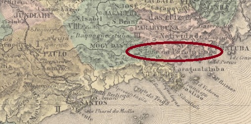
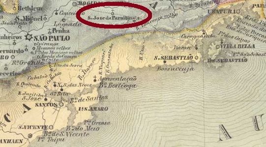
From February 1838, this place was a freguesia of Mogy das Cruzes, which was located on the upper reaches of the Rio Tietê, about 100 km west of the provincial capital of São Paulo. In March 1857 it rose to a villa, which changed its name to Salesopolis in November 1905 and was elevated to a town the following year. The name is reminiscent of the lawyer Manuel Ferraz de Campos Sales (1841-1913), the Brazilian president from 1898 to 1902, who was born in Campinas.
As can be read in the Imperial Mail Register (Tabella das Agencias do Correio do Imperio) from 1885, there is a post office there since 1872. So far only one postmark of the imperial period has been found. SSP-1170a (Coll. José A. Junges) is a French-ype: a double circle with the inscription S. J. DO PARAHYTINGA above and the typical star between brackets below. The date inside shows the year 1888.
Villiers de l’Ile Adam: Carta (…) da Provincia de São Paulo, 1847
Anderer Name: Salesópolis (1905)
Dieser Ort war ab Februar 1838 eine Freguesia von Mogy das Cruzes, die am Oberlauf des Rio Tietê, gut 100 km westlich der Provinzhauptstadt São Paulo lag. Im März 1857 stieg er zu einer Villa auf, die im November 1905 den Namen zu Salesópolis wechselte und im darauffolgenden Jahr zur Stadt erhoben wurde. Der Name erinnert an den Juristen Manuel Ferraz de Campos Sales (1841-1913), den in Campinas geborenen brasilianischen Präsidenten von 1898 bis 1902.
Wie im Verzeichnis der kaiserlichen Postämter (Tabella das Agencias do Correio do Imperio) aus 1885 zu lesen ist, gibt es dort ein Postamt seit 1872. Bisher wurde nur ein Poststempel der Kaiserzeit gefunden. SSP-1170a (Samml. José A. Junges) ist ein Französischer-Typ: ein Doppelkreis mit der Inschrift S. J. DO PARAHYTINGA oben und dem typischen Stern zwischen Klammern unten. Das Datum in der Mitte zeigt das Jahr 1888.
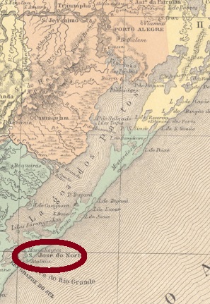
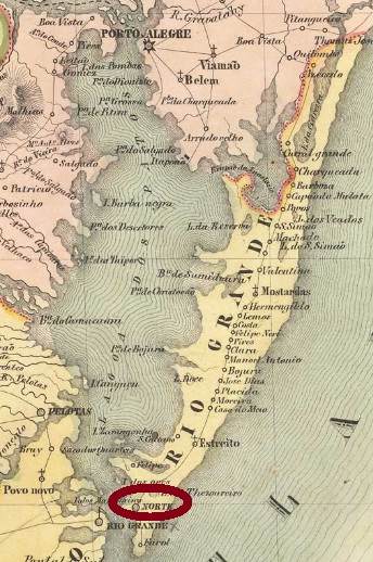
From April 1820, this village was a freguesia of Rio Grande, which was elevated to a villa in October 1831 and was located about 330 km south of the provincial capital Porto Alegre. The name do Norte (“from the north”) refers either to the location north of the mouth of the Lagoa dos Patos, or perhaps in contrast to another place of the same name, which was further south.
Here, too, two dates of origin for the local post office were found: once before, once after the Farroupilha Revolution (1835-1845). It follows that the postal service was temporarily paralyzed during the uprising. According to Nova Monteiro, the post office was first created in October 1831. The Imperial Mail Register (Tabella das Agencias do Correio do Imperio) from 1885 lists the agency from 1847, but this is probably the installing year, since the official creation to open was announced a year earlier:
Annuario Politico, Historico e Estatistico do Brazil, 1846
The oldest cancel is SRS-0335a, which was thought to be from Porto Alegre, for post towards north (Norte). Reinhold Koester nevertheless wrote in Porto Alegre and its cancels until the end of the imperial period (in Brazil, 140 years of postage stamps, ArGe Brazil, 1983) that it was also used on mail from north to Porto Alegre, and thus would be a transit cancel of São José do Norte. The cancel was used until about 1835 and is presented in the RHM catalogue under P-RS-06:
SRS-0335a (RHM P-RS-06)
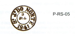
It was followed by SRS-0335b, which is also found in red and brown. Sometimes the year is missing, and this cancel is also shown by RHM:
SRS-0335b (RHM P-RS-05), 1841-1844ff
The last cancel, SRS-0335c (Coll. José A. Junges) is a double circle with the inscription S. JOSÉ DO NORTE above. It also appears in blue and its dates in the middle were found for the period 1876-1886.
Between SRS-0335b and -0335c manuscript cancellations were also common, as this image from a letter of 1873 shows:
1873 (Coll. José A. Junges)Villiers de l’Ile Adam: Carta (…) da Provincia de São Pedro do Sul, 1847
Anderer Name: Norte
Diese Ortschaft war ab April 1820 eine Freguesia von Rio Grande, die bereits im Oktober 1831 zur Villa erhoben wurde, und ca. 330 km südlich der Provinzhauptstadt Porto Alegre lag. Der Name do Norte („aus dem Norden“) bezieht sich entweder aus der Lage nördlich der Mündung der Lagoa dos Patos, oder vielleicht auch in Unterschied zu einem anderen Ort gleichen Namens, der weiter südlich lag.
Auch hier wurden zwei Entstehungsdaten fürs örtliche Postamt gefunden: einmal vor, einmal nach der Farroupilha-Revolution (1835-1845). Daraus folgt, dass der Postbetrieb zeitweise während des Aufstands lahmgelegt wurde. Laut Nova Monteiro entstand das Postamt erstmals im Oktober 1831. Das Verzeichnis der kaiserlichen Postämter(Tabella das Agencias do Correio do Imperio) aus 1885 listet die Agentur ab 1847, das dürfte aber der Zeitpunkt der Inbetriebnahme sein, da die offizielle Anweisung zur Eröffnung ein Jahr zuvor veröffentlicht wurde:
Annuario Politico, Historico e Estatistico do Brazil, 1846
Der älteste Stempel ist SRS-0335a, von dem man dachte, er wäre aus Porto Alegre und für Post nach Norden (Norte) bestimmt. Reinhold Koester schrieb dennoch in Porto Alegre und seine Stempel bis zum Ende der Kaiserzeit (in Brasilien, 140 Jahre Briefmarken, ArGe Brasilien, 1983), dass der Stempel auch auf Post aus Norden nach Porto Alegre verwendet wurde, und dadurch ein Transitstempel von São José do Norte wäre. Der Stempel wurde bis ca. 1835 gebraucht und wird im RHM-Katalog unter P-RS-06 vorgestellt:
SRS-0335a (RHM P-RS-06)
Ihm folgte SRS-0335b, der auch in rot und braun vorkommt und manchmal die Jahresangabe nicht bringt. Ebenfalls im RHM abgebildet:
SRS-0335b (RHM P-RS-05), 1841-1844ff
Der letzte Stempel, SRS-0335c (Samml. José A. Junges) ist ein Doppelkreis mit der Inschrift S. JOSÉ DO NORTE oben. Er kommt auch in blau vor und seine Daten in der Mitte wurden für den Zeitraum 1876-1886 gefunden.
Zwischen SRS-0335b und -0335c wurde offenbar auch per Hand entwertet, wie diese Abbildung aus einem Brief aus 1873 zeigt:
Arthur D. RIbeiro: Mappa do Estado de São Paulo, 1924
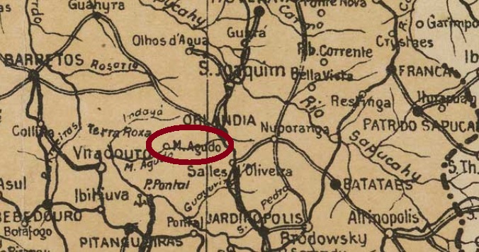
Another name: Morro Agudo
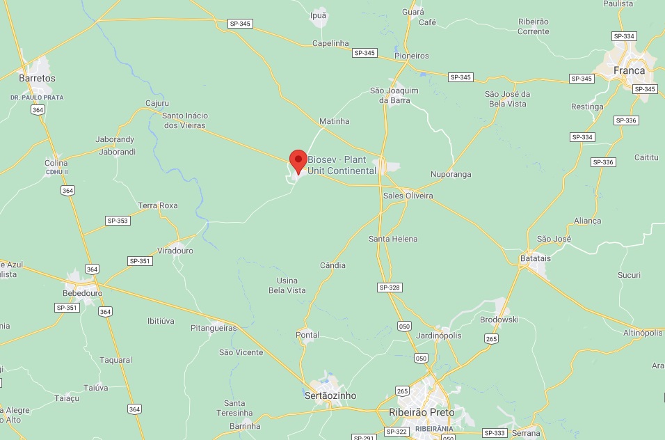
São José do Morro Agudo was a district of Espirito Santo de Batataes, located about 380 km north of the provincial capital São Paulo. In March 1885 it became a freguesia, then from December 1896 it became a district of Nuporanga – as Espirito Santo de Batataes was called from then on. In November 1909, it changed to the new municipality of Orlandia and received the political emancipation in August 1934.
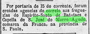
Two origins of the local post office have been identified. First in July 1884, as can be read in the Rio press:
Gazeta de Noticias/RJ, 17 July 1884
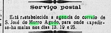
Sometime after that, the agency was closed, as its reopening in November 1888 was announced in the press from S. Paulo:
Correio Paulistano, 30 November 1888
An early cancel was found: SSP-1165a (Coll. José A. Junges) has a double circle with the inscription S. J.M. AGUDO above and an ornament in diamond form below, the four sides of which are open. Dates at the centre: 1890-1896.
Google Maps
Anderer Name: Morro Agudo
São José do Morro Agudo war ein Distrikt von Espirito Santo de Batataes, der gut 380 km nördlich der Provinzhauptstadt São Paulo entfernt lag. Im März 1885 stieg er zur Freguesia, dann wurde er ab Dezember 1896 ein Distrikt von Nuporanga – wie Espirito Santo de Batataes fortan hieß. Im November 1909 wechselte er als Distrikt zum Município von Orlandia und erhielt seine politische Emanzipation im August 1934.
Zwei Entstehungen des örtlichen Postamts wurden ermittelt. Erstmals im Juli 1884, wie aus der Presse in Rio hervorgeht:
Gazeta de Noticias/RJ, 17. Juli 1884
Irgendwann danach war die Agentur geschlossen, da ihre Wiedereröffnung im November 1888 in der Presse aus S. Paulo angekündigt wurde:
Correio Paulistano, 30. November 1888
Ein früher Stempel wurde gefunden: SSP-1165a (Samml. José A. Junges) hat einen Doppelkreis mit der Inschrift S. J. M. AGUDO oben und einem Ornament in Raute unten, dessen vier Seiten offen sind. Daten in der Mitte: 1890-1896.
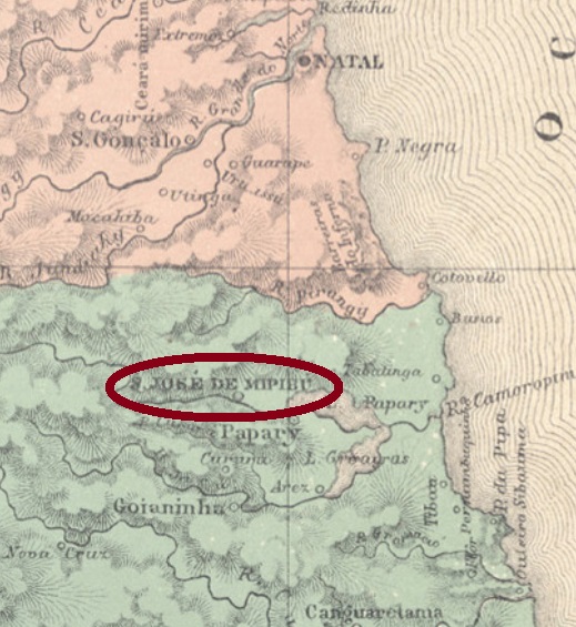
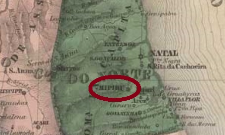
Other names: São José, São José do Rio Grande do Norte, Mipibu
This place is said to have been a villa called S. José do Rio Grande do Norte in 1762, which was located about 40 km south of the future provincial capital Natal. In October 1845, the villa rose to the town of Mipibu, which ten years later was given the full name S. José de Mipibu again. Mipibu is a river named after the Tupi language, that means to appear suddenly. Allegedly, this refers to Indian arrows…
Two different creation dates were found for the local post office. According to Nova Monteiro (Administrações e Agencias Postaes do Brasil Imperio, in Brasil Filatelico/RJ, 1934-5; Reprint SPP 1994-1999) it took place in April 1818, while in the Imperial Mail (Tabella das Agencias do Correio do Imperio) of 1885 the year 1876 is reported. So, we can assume that the agency was closed sometime after 1830 – the date of the last mention in the press. A postmark of the second operating period was found. SRN-0215b (Coll. José A. Junges) has a double circle with the inscription S. J. DE MIPIBU above. The dates at the centre were seen for the period 1883-1885ff.
Villiers de l’Ile Adam: Carta (…) da Provincia do Rio Grande do Norte, 1848
Andere Namen: São José, São José do Rio Grande do Norte, Mipibu
Dieser Ort soll bereits 1762 eine Villa namens S. José do Rio Grande do Norte gewesen sein, die knapp 40 km südlich der künftigen Provinzhauptstadt Natal lag. Im Oktober stieg die Villa zur Stadt von Mipibu auf und erhielt zehn Jahre später den vollständigen Namen S. José de Mipibu wieder. Mipibu heißt der Fluss der Umgebung. Das Wort der Tupi-Sprache soll plötzlich erscheinend bedeuten. Angeblich bezieht sich das auf Indianerpfeile…
Zwei verschiedene Gründungsdaten wurden fürs örtliche Postamt gefunden. Laut Nova Monteiro (Administrações e Agencias Postaes do Brasil Imperio, in Brasil Filatelico/RJ, 1934-5; Reprint SPP 1994-1999) ist es der April 1818, während im Verzeichnis der kaiserlichen Postämter (Tabella das Agencias do Correio do Imperio) von 1885 liest man das Jahr 1876. Also können wir davon ausgehen, dass die Agentur irgendwann nach 1830 – Datum der bisher letzten Erwähnung in der Presse – mal geschlossen wurde. Ein Poststempel der zweiten Betriebsperiode wurde gefunden. SRN-0215b (Samml. José A. Junges) hat einen Doppelkreis mit der Inschrift S. J. DE MIPIBU oben. Die Daten in der Mitte wurden für den Zeitraum 1883-1885ff gesehen.
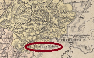
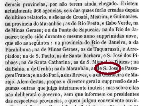
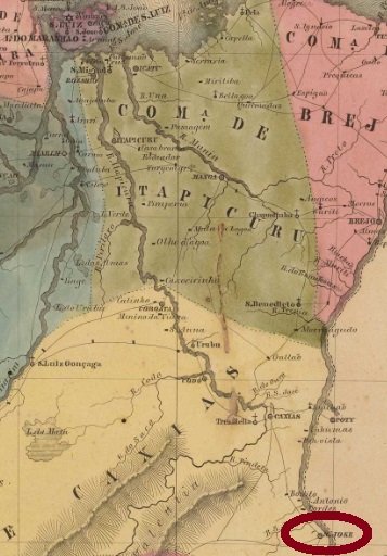
According to Reinhold Koester (Carimbologia XXVII), this village became a villa as early as April 1833, which on the one hand seems a little premature, on the other hand would justify the existence of a post office. The Brazilian Statistics Institute (IBGE) is also somewhat confused here, but one can only assume that the Villa status did not come into force until May 1835. After a rapid economic decline, the village descended to a district of Caxias in 1855, only to re-enter as villa in July 1863. From 1864 to 1870, the headquarters of the municipality were moved to S. José das Cajazeiras (see SMA-0235), but finally returned for good. Since December 1943, this municipality has been simply called Matões. It is located close to the border with Piauí, more than 460 km southeast of the then provincial capital, São Luís.
The local post office was established at least twice. The first founding date has not yet been found, but it is known that the agency was closed around 1846, as can be seen from the official annual report (Annuario Politico, Historico e Estatistico do Brazil) for 1847:
Annuario Politico, Historico e Estatistico, 1847
The second opening of the post office did not take place until February 1875, as can be read in the Post Report (Relatorio Postal) for 1887. So far, no cancel of the imperial period has been found for this village.
Villiers de l’Ile Adam: Carta (…) da Provincia do Maranhão
Andere Namen: São José, Matões (1943)
Siehe auch Mattões (Koester: Carimbologia XXVII)
Laut Reinhold Koester (Carimbologia XXVII) wurde diese Ortschaft bereits im April 1833 eine Villa, was einerseits etwas verfrüht erscheint, andererseits die Existenz eines Postamts rechtfertigen würde. Auch die brasilianische Statistikbehörde (IBGE) bringt hier etwas durcheinander, aber man darf letztendlich annehmen, dass der Villa-Status erst im Mai 1835 in Kraft trat. Nach einem raschen wirtschaftlichen Niedergang stieg 1855 der Ort zum Distrikt von Caxias ab, um im Juli 1863 wieder als Villa aufzusteigen. Von 1864 bis 1870 wurde der Hauptsitz des Município nach S. José das Cajazeiras (siehe SMA-0235) verlegt, kehrte aber danach endgültig zurück. Seit Dezember 1943 heißt dieser Município einfach Matões. Er liegt nah an der Grenze zu Piauí, über 460 km südöstlich der damaligen Provinzhauptstadt São Luís entfernt.
Das örtliche Postamt wurde mindestens zweimal gegründet. Das erste Gründungsdatum wurde noch nicht gefunden, aber man weiß immerhin, dass die die Agentur um 1846 geschlossen wurde, wie aus dem amtlichen Jahresbericht (Annuario Politico, Historico e Estatistico do Brazil) für 1847 hervorgeht:
Annuario Politico, Historico e Estatistico, 1847
Die zweite Postamtseröffnung fand erst im Februar 1875 statt, wie im Postbericht (Relatorio Postal) für 1887 zu lesen ist. Bisher wurde kein Stempel der Kaiserzeit für diese Ortschaft gefunden.
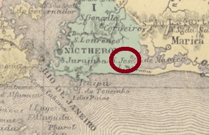
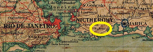
This village already existed in 1675, when the small chapel of S. José do Imbassahy was built on the west end of the lagoon of Maricá, about 50 km east of the later imperial capital Rio de Janeiro. Since May 1814, it was part of the villa of Maricá, since December 1889 it has been a rural suburb of the town of Maricá and since 1890 it has been called again S. José do Imbassahy (also written Imbassaí or Imbaçaí). The word from the tupi language means river way.
The local post office was established in 1880, as can be read in the Imperial Mail Register (Tabella das Agencias do Correio do Imperio) of 1885. So far, no postmark of the imperial era has been found.
Almanak Laemmert, 1892
Anderer Name: S. José do Imbassahy
Diese Ortschaft existierte bereits 1675, als die kleine Kapelle von S. José do Imbassahy am Westufer der Lagune von Maricá erbaut wurde, ca. 50 km östlich der späteren kaiserlichen Hauptstadt Rio de Janeiro entfernt. Der Ort gehörte ab Mai 1814 zur Villa von Maricá, ist seit Dezember 1889 ein ländlicher Vorort der Stadt Maricá und heißt seit 1890 wieder S. José do Imbassahy (heute Imbassaí oder Imbaçaí geschrieben). Das Wort aus der Tupi-Sprache bedeutet Weg zum Fluss.
Other names: São José de Leonissa da Aldeia da Pedra, Itaocara (1891)
See also Aldeia da Pedra (R. Koester: Carimbologia XXX)
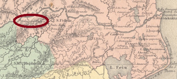
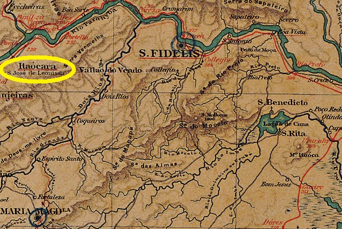
This village was from March 1850 the district of S. José de Leonissa da Aldeia da Pedra, located on the south bank of the river Paraíba do Sul in the municipality of S. Fidélis, about 260 km northwest of the imperial capital Rio de Janeiro. In October 1890, it became the Villa of Itaocara, since then in own municipality. The word Itaocara comes from the Tupi language and means village of stones (= Aldeia da Pedra).
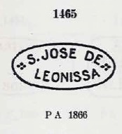
According to Paulo Novaes (agenciaspostais.com.br), the local post office was created in November 1833 under the name Aldeia da Pedra. The name changed to S. José de Leonissa in 1866. For cancels under Aldeia da Pedra see R. Koester’s Carimbologia XXX. The first three town cancels under S. José de Leonissa were already made known by Paulo Ayres (Catalogo de Carimbos Brasil-Império, S. Paulo, 1937, 1942). SRJ-1425a corresponds to P. Ayres No. 1465 and was found on stamps of the first D. Pedro issue (1866):
SRJ-1425a (P.Ayres 1465)
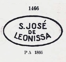
It was followed by SRJ-1425b, which is identical to P. Ayres No. 1466 and was used at least until 1878:
SRJ-1425b (P. Ayres 1466)
The first cancel in double circle is SRJ-1425c. It was found with dates from 1875 to 1885 and corresponds to the image shown by P. Ayres (op. cit. p. 125):
SRJ-1425c (P. Ayres p./S. 125) 1875-1885
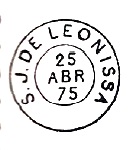
It was followed by two cancels in a double circle with a lower ornament. SRJ-1425d (Coll. José A. Junges) has above the inscription S. JE DE LEONISSA. The ornament below is a diamond formed by four small diamonds. Dates at the centre: 1886-1888. SRJ-1425e (Coll. Paulo Novaes) has above the inscription S. JE. DE LEONISSA, and the ornament below are two outward-facing arrowheads. Internal dates: 1889-1890.
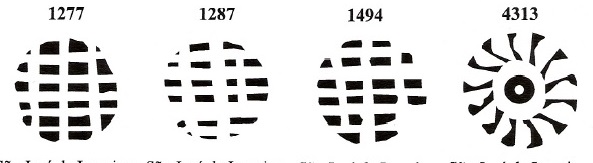
In addition, there were five mute cancels. Four of them have already been presented by J. Dingler and K. W. Lopes in Mute Cancellations of the Brazil Empire/ Carimbos Mudos do Brasil Império (Brazil Philatelic Association, Rio de Janeiro, 2000):
BPA 1277, 1287, 1494, 4313 (1878)
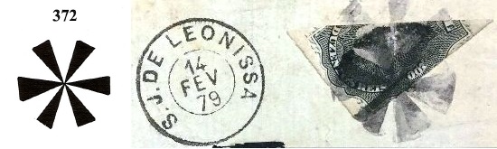
The fifth mute cancel could be the No. 372 by J. Dingler and Kl. W. Lopes (op. cit.) and was used in 1879 in conjunction with SRJ-1425c:
BPA 372, 1879 (image from the Internet)Almanak Laemmert, 1892
Andere Namen: São José de Leonissa da Aldeia da Pedra, Itaocara (1891)
Siehe auch Aldeia da Pedra (R. Koester: Carimbologia XXX)
Diese Ortschaft war ab März 1850 der Distrikt von S. José de Leonissa da Aldeia da Pedra, am Südufer des Flusses Paraíba do Sul im Município von S. Fidélis gelegen, ca. 260 km nordwestlich der kaiserlichen Hauptstadt Rio de Janeiro entfernt. Im Oktober 1890 stieg sie zur Villa von Itaocara, seitdem auch ein eigener Município. Das Wort Itaocara stammt aus der Tupi-Sprache und bedeutet Dorf der Steine (Aldeia da Pedra).
Laut Paulo Novaes (agenciaspostais.com.br) wurde das örtliche Postamt im November 1833 unter dem Namen Aldeia da Pedra gegründet. Der Namenswechsel zu S. José de Leonissa erfolgte ca. 1866. Für Stempel unter Aldeia da Pedra siehe R. Kosters Carimbologia XXX. Die ersten drei Ortsstempel unter S. José de Leonissa wurden bereits durch Paulo Ayres (Catálogo de Carimbos Brasil-Império, S. Paulo, 1937, 1942) bekannt gemacht. SRJ-1425a entspricht P. Ayres Nr. 1465 und wurde auf Marken der ersten D.Pedro-Ausgabe (1866) gefunden:
SRJ-1425a (P. Ayres 1465)
Ihm folgte SRJ-1425b, der mit P. Ayres Nr. 1466 identisch ist und mindestens bis 1878 verwendet wurde:
SRJ-1425b (P. Ayres 1466)
Der erste Stempel im Doppelkreis ist SRJ-1425c. Er wurde mit Daten von 1875 bis 1885 gefunden und entspricht P. Ayres (S. 125) Abbildung:
SRJ-1425c (P. Ayres P./S. 125) 1875-1885
Ihm folgten zwei Stempel im Doppelkreis mit unterem Ornament. SRJ-1425d (Sammlung José A. Junges) hat oben die Inschrift S. JE DE LEONISSA. Das Ornament unten ist eine Raute, die von vier kleinen Rauten gebildet wird. Daten in der Mitte: 1886-1888. SRJ-1425e (Sammlung Paulo Novaes) hat oben die Inschrift S. JE. DE LEONISSA, und das Ornament unten sind zwei nach außen gerichteten Pfeilspitzen. Inneren Daten: 1889-1890.
Darüber hinaus waren fünf stumme Entwertungen zu finden. Vier davon wurden bereits durch J. Dingler und K. W. Lopes in Mute Cancellations of the Brazil Empire/ Carimbos Mudos do Brasil Império (Brazil Philatelic Association, Rio de Janeiro, 2000) vorgestellt :
BPA 1277, 1287, 1494, 4313 (1878)
Der fünfte stumme Stempel könnte die Nr. 372 von J. Dingler und Kl. W. Lopes (op. cit.) sein und war 1879 in Verbindung mit SRJ-1425c verwendet:
This was an ancient settlement belonging to Caetés, Santa Barbara, Rio Piracicaba and finally Itabira, and in October 1848 it became a freguesia on the northern bank of the Piracicaba River, about 140 km northeast of the provincial capital Ouro Preto. In December 1938, it rose to the municipality of Presidente Vargas, a kowtowing to the Brazilian dictator. In June 1942 the place name changed again, this time to the current Nova Era.
Paula Sobrinho (História Postal de Minas Gerais, Belo Horizonte, 1997) writes that the local post office was created in March 1887, but this must be a misprint, because earlier cancel dates are available, and the Imperial Mail Register (Tabella das Agencias do Correio do Imperio) of 1885 lists the agency from 1877 on. The only cancel of the imperial period seems to be SMG-2425a (Coll. Karlheinz Wittig). A double circle with the inscription S. JOSÉ DA LAGOA above and an ornament in diamond at the bottom, consisting of four small diamonds. The dates in the centre originate from the period 1884 to 1894.
Villiers de l’Ile Adam: Carta (…) da Provincia de Minas Geraes, 1849
Andere Namen: Presidente Vargas, Nova Era (1942)
São José da Lagoa war eine alte Siedlung, die zu Caetés, Santa Barbara, Rio Piracicaba und schließlich zu Itabira gehörte und im Oktober 1848 zu einer Freguesia aufstieg, die am Nordufer des Rio Piracicaba lag, gut 140 km nordöstlich der Provinzhauptstadt Ouro Preto entfernt. Im Dezember 1938 wurde daraus der Município von Presidente Vargas, ein Kotau gegenüber dem damaligen brasilianischen Diktator. Im Juni 1942 änderte sich abermals der Ortsnamen, diesmal zum aktuellen Nova Era.
This village was formerly a freguesia called Lage do Canhoto, which was located at Vila Nova da Imperatriz on the west bank of the Canhoto River (= left-handed), about 100 km north of the provincial capital Maceió. In July 1876, it rose to a villa, but six years later it was demoted back to a district, now under the name S. José da Lage. The villa status returned in June 1886, and today the municipality of S. José da Laje is written with j.
Two different years were found for the creation of the local post office. Aldo Cardoso (Contribuição para a História dos Correios de Alagoas, Maceió, 1969) writes the quite early year 1835, which may be a misprint. And the Imperial Mail Register (Tabella das Agencias do Correio do Imperio) from 1885 lists the agency from 1872 on, which would be rather plausible. A postmark of the 19th century is available, probably not the oldest. SAL-0205b (Coll. Karlheinz Wittig) has a double circle with the inscriptions S. JOSÉ DA LAGE above and (ALAGOAS) below. The dates at the Centre originate from the period 1891-1894.
ca. 1950
Anderer Name: Lage do Canhoto
Diese Ortschaft war früher eine Freguesia namens Lage do Canhoto, die bei Vila Nova da Imperatriz am Westufer des Flusses Canhoto (= Linkshänder) lag, gut 100 km nördlich der Provinzhauptstadt Maceió entfernt. Im Juli 1876 stieg sie zur Villa auf, aber bereits 6 Jahre später wurde sie zum Distrikt rückgestuft, unter dem Namen S. José da Lage. Der Villa-Status kehrte im Juni 1886 zurück, und heute schreibt sich der Município Laje, mit j.
Zwei Jahresangaben wurden für die Entstehung des örtlichen Postamtes gefunden. Aldo Cardoso (Contribuição para a História dos Correios de Alagoas, Maceió, 1969) schreibt bereits das Jahr 1835, was ein Druckfehler sein mag. Und das Verzeichnis der kaiserlichen Postämter (Tabella das Agencias do Correio do Imperio) von 1885 listet die Agentur ab 1872 auf, was eher plausibel wäre. Ein Poststempel des 19. Jahrhunderts liegt vor, wohl nicht der älteste. SAL-0205b (Samml. Karlheinz Wittig) hat einen Doppelkreis mit den Inschriften S. JOSÉ DA LAGE oben und (ALAGOAS) unten. Die Daten im Zentrum wurden für den Zeitraum 1891-1894 ermittelt.
Carta da Republica dos Estados Unidos do Brazil, 1892
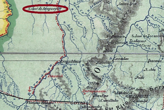
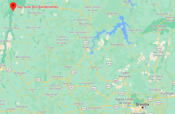
Other names: S. José do Janimbu, S. José do Araguaya, S. José dos Bandeirantes, Bandeirantes
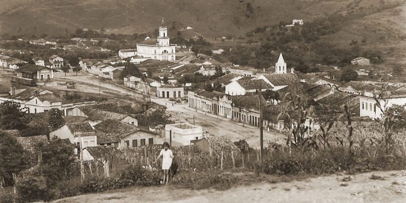
The history of this village began in 1845, with the establishment of a Franciscan mission on the east bank of the Araguaia River, located about 320 km north of the provincial capital Goyaz (today Goiás Velho). In March 1938, it changed to the municipality of Pilar, and in October 1953 became a district called S. José dos Bandeirantes in the newly founded municipality of Crixás. This is a tributary of the Araguaia, named after a now almost extinct Indian tribe. The place’s name was later simplified to Bandeirantes, which since June 1980 was a district of the then-created municipality of Nova Crixás.
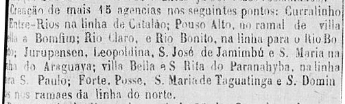
Two creation years for the local post office were found. In the Imperial Mail Register (Tabella das Agencias do Correio do Imperio) of 1885, an agency called S. José de Janimbu is listed from 1870 on. And the report of the provincial president of June 1875 refers to a new post office in S. José de Jamimbú:
Relatorio do Presidente da Provincia, in Correio Official de Goyaz, 15 September 1875.
Until now, no postmark of the imperial era could be seen from this place. No wonder, considering that there were only 532 people on place at the beginning of the republic, most of whom were illiterate.
Google Maps
Andere Namen: S. José do Janimbu, S. José do Araguaya, S. José dos Bandeirantes, Bandeirantes
Die Geschichte dieser Ortschaft fing 1845 an, mit der Gründung einer Franziskanermission am Ostufer des Araguaia-Flusses, gut 320 km nördlich der Provinzhauptstadt Goyaz (heute Goiás Velho) gelegen. Im März 1938 wechselte er zur Gemeinde Pilar, und wurde erst im Oktober 1953 ein Distrikt mit Namen S. José dos Bandeirantes im neu gegründeten Município von Crixás. Dieser ist ein Nebenfluss des Araguaia, genannt nach einem inzwischen fast ausgestorbenen Indianerstamm. Der Ortsname wurde später zu Bandeirantes vereinfacht, der seit Juni 1980 ein Distrikt vom damals entstandenen Município von Nova Crixás.
Relatorio do Presidente da Provincia, in Correio Official de Goyaz, 15. September 1875.
Bisher war kein Poststempel der Kaiserzeit aus diesem Ort zu sehen. Kein Wunder, wenn man bedenkt, dass dort am Anfang der Republik lediglich 532 Menschen lebten, und die allermeisten davon Analphabeten waren.