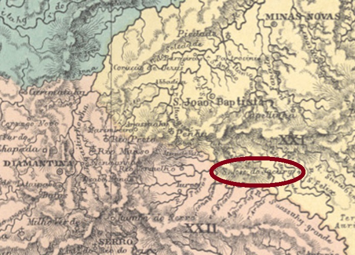
São José do Jacury (now written Jacuri) was from May 1852 on a district of Minas Novas, named after a small river and situated almost 400 km north of the provincial capital Ouro Preto. In September 1862, it changed to the new municipality of S. João Baptista (today Itamarandiba) and in October 1875, to Pessanha. It has been a municipality since December 1953.
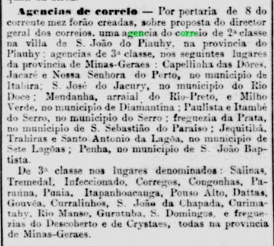
The local post office has existed since November 1881, as Paula Sobrinho writes in Historia Postal de Minas Gerais (Belo Horizonte, 1997), which is confirmed by the Rio press:
Jornal do Commercio/RJ, 12 November 1881
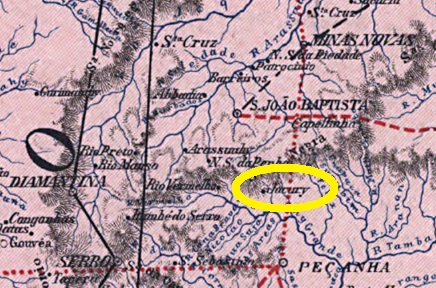
An early postmark of this village was found, which is probably not the oldest one. SMG-2460b (Coll. Marcio Protzner) has a double circle with the inscriptions S. JOSÉ DO JACURY above and (MINAS) below. The only copy bears a date from 1904 at the centre.
Carta da Republica dos Estados Unidos do Brazil, 1892
Anderer Name: Jacury
São José do Jacury (heute Jacuri geschrieben) war ab Mai 1852 ein Distrikt von Minas Novas, der nach einem kleinen Fluss genannt wurde und fast 400 km nördlich der Provinzhauptstadt Ouro Preto entfernt lag. Im September 1862 wechselte er als Distrikt zum neu gegründeten Município von S. João Baptista (heute Itamarandiba) und im Oktober 1875 wechselte er abermals zur entstandenen Gemeinde von Pessanha. S. João do Jacuri ist seit Dezember 1953 ein eigener Município.
Das örtliche Postamt gibt es seit November 1881, wie Paula Sobrinho in Historia Postal de Minas Gerais (Belo Horizonte, 1997) schreibt, und von der Presse aus Rio bestätigt wird:
Jornal do Commercio/RJ, 12. November 1881
Ein früher Poststempel dieser Ortschaft wurde gefunden, der wohl nicht der älteste ist. SMG-2460b (Samml. Marcio Protzner) hat einen Doppelkreis mit den Inschriften S. JOSÉ DO JACURY oben und (MINAS) unten. Das einzige Exemplar trägt ein Datum von 1904 in der Mitte.
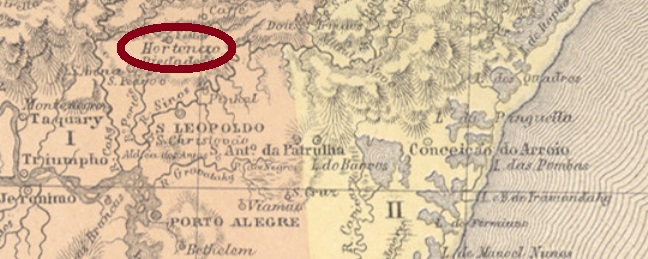
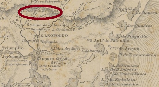
From July 1848, this village was a district of São Leopoldo, located on the west bank of the river Cadeia (Prison), about 70 km north of the provincial capital Porto Alegre. In May 1875, the district moved to the newly founded municipality of São Sebastião do Cahy and gained its political autonomy in April 1888. The name Hortencio is said to be reminiscent of Hortencio Leite de Oliveira, a Portuguese landowner of the region.
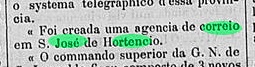
The local post office was created in July 1885, according to the regional press:
A Federação, 22 July 1885
An early cancel was found, unfortunately with a date from the Republic. SRS-0330a (Coll. FM) has a double circle with the inscription S. J. DO HORTENCIO above and an ornament in cross below, which consists of four small branches. The date of the only copy to date shows in the centre the year 1897.
Provincia de São Pedro do Rio Grande, 1877
Diese Ortschaft war ab Juli 1848 ein Distrikt von São Leopoldo, der amWestufer des Flusses Cadeia (Gefängnis) lag, gut 70 km nördlich der Provinzhauptstadt Porto Alegre entfernt. Im Mai 1875 wechselte der Distrikt zum neu gegründeten Município von São Sebastião do Cahy und erhielt seine politische Autonomie im April 1888. Der Name Hortencio soll an Hortencio Leite de Oliveira erinnern, einem portugiesischen Großgrundbesitzer der Region.
Das örtliche Postamt wurde im Juli 1885 gegründet, wie aus der Regionalpresse hervorgeht:
A Federação, 22. Juli 1885
Ein früher Stempel wurde gefunden, leider mit einem Datum aus der Republik. SRS-0330a (Samml. FM) hat einen Doppelkreis mit der Inschrift S. J. DO HORTENCIO oben und einem Ornament in Kreuz unten, das aus vier kleinen Zweigen besteht. Das Datum des bisher einzigen Exemplars zeigt in der Mitte das Jahr 1897.
Carta da Republica dos Estados Unidos do Brazil, 1892
Other names: Herculanea, Belliago, Taquary, Coxim (1898)
See also Herculanea (R. Koester: Carimbologia XXI)
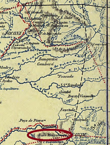
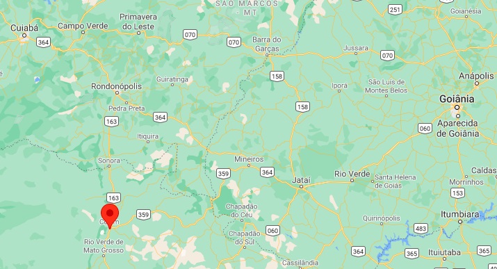
This village has a long but very patchy history, as so often in this province. Founded as Arraial de Belliago (named after the founder) around 1730, it was located on the east bank of the Taquary River, more than 450 km south of the later provincial capital Cuiabá. Later, the name changed to Taquary, until the district was officially named S. José de Herculanea in November 1872, after the former provincial governor Herculano Ferreira Penna (1811-1867). In April 1898, it became the municipality of Coxim, which has been part of the state of Mato Grosso do Sul since October 1977. Coxim is the river that flows into the Taquary around this locality.
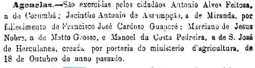
Both the Imperial Mail Register (Tabella das Agencias do Correio do Imperio, 1885) and Reinhold Koester list the local post office with founding year 1880, but it could also have been a year later, as can be read in the report of the provincial president of June 1882:
Relatorio do Presidente da Provincia, June 1882
This second date is confirmed by the Rio de Janeiro press. So far, no postmark of the imperial era with exactly this name has been found. For cancels featuring only HERCULANEA see Koester, Carimbologia XXI.
Google Maps
Andere Namen: Herculanea, Belliago, Taquary, Coxim (1898)
Siehe auch Herculanea (R. Koester: Carimbologia XXI)
Diese Ortschaft hat eine lange, aber sehr lückenhafte Geschichte, wie so oft in dieser Provinz. Gegründet als Arraial de Belliago (genannt nach dem Gründer) um 1730, sie lag am Ostufer des Flusses Taquary, über 450 km südlich der späteren Provinzhauptstadt Cuiabá. Später wechselte der Name zu Taquary, bis der Distrikt im November 1872 unter dem Namen S. José de Herculanea offiziell genannt wurde, nach dem ehemaligen Provinzgouverneur Herculano Ferreira Penna (1811-1867). Im April 1898 kam die politische Autonomie als Município von Coxim, der seit Oktober 1977 dem Bundesstaat Mato Grosso do Sul angehört. Coxim heißt der Fluss, der an dieser Stelle in den Taquary mündet.
Dieses zweite Datum wird von der Presse aus Rio bestätigt. Bisher wurde kein Poststempel der Kaiserzeit mit exakt diesem Namen gefunden. Für Stempel nur mit HERCULANEA siehe Koester, Carimbologia XXI.
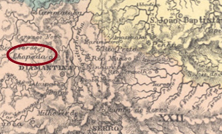
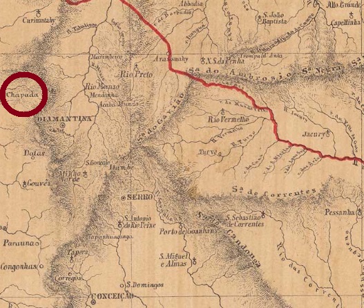
Other names: Chapada, São João, São João Baptista da Chapada
From September 1870, this village was a district called Chapada, located near Diamantina, about 400 km north of the provincial capital Ouro Preto. In November 1873, an additional São João was given to the toponym, and so it has remained to this day.
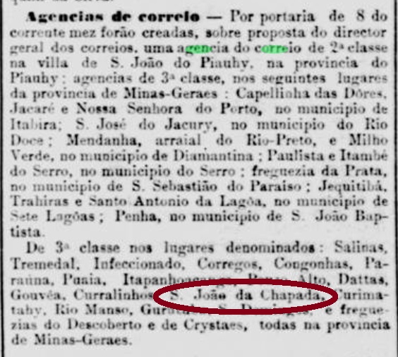
As Paula Sobrinho writes in Historia Postal de Minas Gerais (Belo Horizonte, 1997), the local post office was created in November 1881. This is confirmed by the Rio press, although this date has now been postponed five days later.
Jornal do Commercio/RJ, 12 November 1881
A postmark of the imperial period was found: SMG-2345a (Coll. José A. Junges) is a double circle with the inscription S. JOĀO DA CHAPADA above and an ornament in diamond below, which is formed from four small diamonds. The dates inside go from 1886 to 1897.
Provincia de Minas Geraes, 1873
Andere Namen: Chapada, São João, São João Baptista da Chapada
Diese Ortschaft war ab September 1870 ein Distrikt namens Chapada, der bei Diamantina lag, knapp 400 nördlich der Provinzhauptstadt Ouro Preto entfernt. Im November 1873 kam der Zusatz São João dazu, und so ist es bis heute geblieben.
Wie Paula Sobrinho in História Postal de Minas Gerais (Belo Horizonte, 1997) schreibt, entstand das örtliche Postamt im November 1881. Dies wird durch die Presse aus Rio bestätigt, wenngleich dieses Datum nun fünf Tage später verlegt wurde.
Jornal do Commercio/RJ, 12. November 1881
Ein Poststempel der Kaiserzeit wurde gefunden: SMG-2345a (Samml. José A. Junges) ist ein Doppelkreis mit der Inschrift S. JOĀO DA CHAPADA oben und einem Ornament in Raute unten, das aus vier kleinen Rauten gebildet wird. Die Daten im Inneren gehen von 1886 bis 1897.
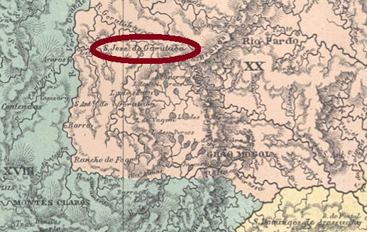
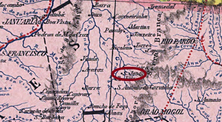
S. José do Gorotuba was a district of Grão-Mogol, located almost 670 km north of the provincial capital Ouro Preto. In September 1923, the place name was and slightly changed and simplified to Gorutuba, and since September 1938 the district belongs to the new municipality of Porteirinha.
According to Paula Sobrinho (História Postal de Minas Gerais, Belo Horizonte, 1997), there was a post office there from November 1881, but it was closed in July 1934. So far, no postmark of the Empire has been found for this village.
Carta da Republica dos Estados Unidos do Brazil, 1892
Anderer Name: Gorutuba (1923)
S. José do Gorotuba war ein Distrikt von Grão-Mogol, der fast 670 km nördlich der Provinzhauptstadt Ouro Preto entfernt lag. Im September 1923 wurde der Ortsname zu Gorutuba vereinfacht und leicht verändert, und seit September 1938 gehört der Ort zum neuen Município von Porteirinha.
Laut Paula Sobrinho (História Postal de Minas Gerais, Belo Horizonte, 1997) gab es dort ein Postamt ab November 1881, der allerdings im Juli 1934 geschlossen wurde. Bisher wurde kein Poststempel des Kaiserreichs für diese Ortschaft gefunden.
Villiers de l’Ile Adam: Carta (…) da Provincia de Minas Geraes, 1849
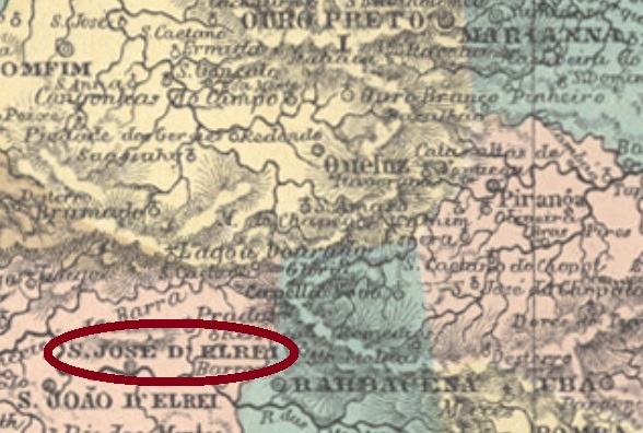
Other names: São José do Rio das Mortes, Tiradentes (1889)
This historic location was already a villa in 1719, which was called S. José do Rio das Mortes and situated about 160 km southwest of the later provincial capital Ouro Preto. The Rio das Mortes (River of the Dead) originates from the Serra da Mantiqueira and flows about 500 km to the west until it reaches the Funil dam near Ijaci, where a hydroelectric power station is in operation today.
The place name changed to S. José d’El-Rey at the beginning of the Empire, and the place was also a district of the neighbouring S. João d’El-Rei for a short time (1848-49), before it regained its status as a villa. Since October 1860 it has been a city called Tiradentes from December 1889. The peculiar name (= teeth puller) is reminiscent of the martyr Joaquim José da Silva Xavier (1746-1792), an ensign born in the region who worked as a dentist and was executed as an independence fighter by the Portuguese colonial authorities.
Three dates for the local post office are available. Paula Sobrinho (História Postal de Minas Gerais, Belo Horizonte, 1997) writes the March 1798, making it one of the oldest postal agencies in Brazil. Nova Monteiro Monteiro (Administrações e Agencias Postaes do Brasil Imperio, in Brasil Filatelico/RJ, 1934-5; Reprint SPP 1994-1999) lists the post office from January 1825. Finally, in the Postal Report (Relatorio Postal) for 1890 states a creation in March 1829. This suggests the post office was probably closed in between. The oldest cancel to date is SMG-3795a, which is listed in the RHM catalogue under P-MG-59:
SMG-3795a (RHM: P-MG-59) 1829-1839
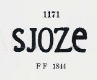
It was followed by SMG-3795b, which also appears, slightly changed, in blue, brown, red, and crimson and was depicted by Paulo Ayres (Catalogo de Carimbos Brasil-Império, S. Paulo, 1937, 1942) under No. 1171:
SMG-3795b (P.A. 1171), 1836-1866ff
The next cancel already bears the complete place name; SMG-3620a, was also shown by P. Ayres (op. cit.):
SMG-3620a (P.A. op. cit.) 1882
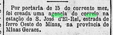
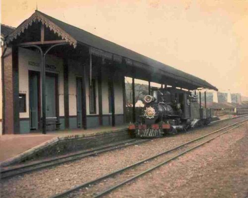
In August 1881, the local station was inaugurated by the E. F. Oeste de Minas Railway Company on the so-called Paraopeba Line. Later in the Republic, the line changed hands several times: in 1931 to the Rede Mineira de Viação, in 1965 to Viação Férrea Centro-Oeste, in 1975 to the Rede Ferroviaria Federal S.A. and finally in 1996 to the present day it belongs to the Ferrovia Centro-Atlântica. Today, the train is only used for tourist trips on weekends and during holidays.
In 1978 (Photo: Julio Moraes, estacoesferroviarias.com.br)
Two creation dates were found for the station post office. The Postal Report (Relatório Postal) for 1890 recorded the September 1882. And the press from Rio writes about the new railway post office exactly one year later:
Gazeta de Noticias/RJ, 20.09.1883
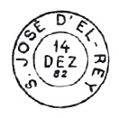
A postmark of this station agency was also found: SMG-3621a (Coll. Márcio Protzner) has a double circle with the inscriptions S. JOSÉ-D’EL-REY above and (ESTAÇÃO) below. The dates at the centre come from the period 1889-1890.
Atlas do Imperio do Brasil, 1868
Andere Namen: S. José do Rio das Mortes, Tiradentes (1889)
Diese geschichtsreiche Gemeinde war schon eine Villa in 1719, die S. José do Rio das Mortes hieß und ca. 160 km südwestlich der späteren Provinzhauptstadt Ouro Preto entfernt lag. Der Rio das Mortes (Fluss der Toten) entspring der Serra da Mantiqueira und fließt ca. 500 km nach Westen, bis er den Staudamm Funil bei Ijaci erreicht, wo heute ein Wasserkraftwerk in Betrieb ist.
Der Ortsname wechselte am Anfang des Kaiserreichs zu S. José d’El-Rei, und der Ort war kurzzeitig (1848-49) auch ein Distrikt vom benachbarten S. João d’El-Rei, bevor er seinen Status als Villa wiedererlangte. Seit Oktober 1860 ist er eine Stadt, die ab Dezember 1889 Tiradentes heißt. Der eigentümliche Name (= Zähnezieher) erinnert an den Märtyrer Joaquim José da Silva Xavier (1746-1792), einen in der Gegend geborenen Fähnrich, der nebenbei als Zahnarzt arbeitete und als Unabhängigkeitskämpfer von der portugiesischen Kolonialmacht hingerichtet wurde.
Drei Entstehungsdaten fürs örtliche Postamt sind vorhanden. Paula Sobrinho (História Postal de Minas Gerais, Belo Horizonte, 1997) schreibt dafür den März 1798, und damit wäre diese eine der ältesten Postagenturen Brasiliens. Nova Monteiro (Administrações e Agencias Postaes do Brasil Imperio, in Brasil Filatelico/RJ, 1934-5; Reprint SPP 1994-1999) listet das Postamt ab Januar 1825 auf. Schließlich liest man im Postbericht (Relatorio Postal) für 1890 hingegen den März 1829. Also war das Postamt wohl zwischendurch geschlossen. Der bisher älteste Stempel ist SMG-3795a, der im RHM Katalog unter P-MG-59 aufgelistet ist:
Der nächste Stempel trägt bereits den vollständigen Ortsnamen und dürfte SMG-3620a sein, wie ihn P. Ayres (op. cit.) zeigte:
SMG-3620a (P.A. op. cit.) 1882
Im August 1881 wurde der lokale Bahnhof durch die E. F. Oeste de Minas Eisenbahngesellschaft in der sogenannten Paraopeba-Linie eingeweiht. Später in der Republik wechselte die Linie den Besitzer mehrmals: 1931 zur Rede Mineira de Viação, 1965 zur Viação Férrea Centro-Oeste, 1975 zur Rede Ferroviaria Federal S.A. und schließlich 1996 bis heute gehört sie der Ferrovia Centro-Atlântica. Heute ist der Zug nur für touristische Fahrten am Wochenende und in den Ferien unterwegs.
In 1978 (Foto: Julio Moraes, estacoesferroviarias.com.br)
Für das Bahnhofspostamt haben wir zwei Entstehungsdaten gefunden. Der Postbericht (Relatorio Postal) für 1890 schreibt hierfür den September 1882. Und die Presse aus Rio berichtet über das neue Bahnpostamt genau ein Jahr später:
Gazeta de Noticias/RJ, 20.09.1883
Ein Poststempel dieser Bahnhofsagentur wurde auch gefunden: SMG-3621a (Samml. Márcio Protzner) hat einen Doppelkreis mit den Inschriften S. JOSÉ-D’EL-REY oben und (ESTAÇÃO) unten. Die Daten in der Mitte entstammen dem Zeitraum 1889-1890.
Real Archivo Militar de Lisboa, 1823 (agenciaspostais.com.br)
Other names: São Bernabé, Villa Nova de Itamby, Itambi
See also São Bernabé (SRJ-0913)
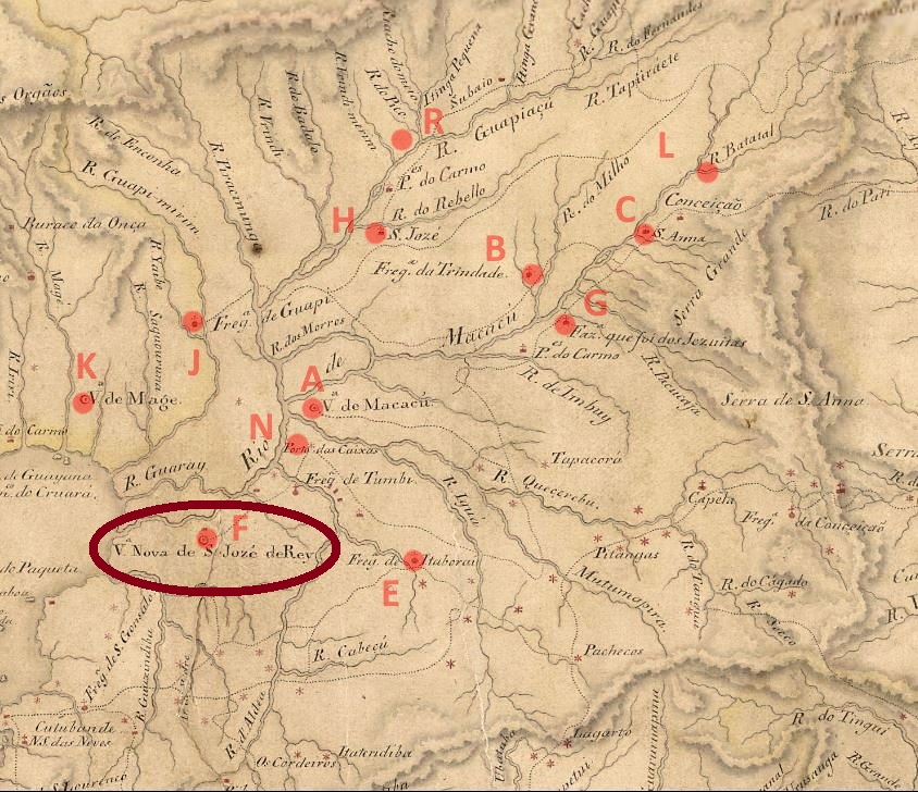
This post office was discovered through the Carimbologia project: a locality which disappeared almost 200 years ago, i.e. still in the pre-philatelic period, and belonged to a municipality that no longer exists, either. It began in November 1759, with the foundation of the freguesia of Nossa Senhora do Desterro de Itamby, which took part of the now extinct municipality of Santo Antonio de Sá, located under 50 km northeast of the imperial capital. In 1772 it became a villa called São José del Rei, that after a short decadence went in 1833 as the freguesia of São Bernabé to the municipality of São João de Itaborahy. This status remained until 1840, when São Bernabé merged with other localities into the Villa Nova de Itamby, which is now Itambi, in the outskirts of the town of Itaboraí. We don’t know the causes of such a turbulent history, whether they are political, economic, or ecological nature, or even a combination among them.
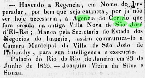
No creation date for the local post office has been found until now, but it was closed by June 1835, according to official reports:
Correio Official, 30 de junho de 1835
No postal cancel from this locality has been found so far.
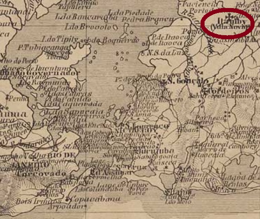
Carta Corographica do Rio de Janeiro, 1867
Andere Namen: São Bernabé, Villa Nova de Itamby, Itambi
Siehe auch São Bernabé (SRJ-0913)
Dieses Postamt wurde durch die Carimbologia-Recherchen entdeckt: eine vor fast 200 Jahren verschwundene Ortschaft – also noch in der Vorphila-Ära – die einer Gemeide angehörte, die inzwischen auch nicht mehr existiert. Die Geschichte begann im November 1759 mit der Gründung der Freguesia von Nossa Senhora do Desterro de Itamby im inzwischen ausgelöschten Município von Santo Antonio de Sá, knapp 50 km nordöstlich der kaiserlichen Hauptstadt Rio de Janeiro gelegen. 1772 wurde daraus die Villa von São José del Rei, die nach einem raschen Verfall im Jahr 1833 zur Freguesia von São Bernabé im Município von São João de Itaborahy abstieg. Dieser Status hielt bis 1840, als São Bernabé mit anderen Ortschaften zur Villa Nova de Itamby (heute Itambi) wurde, heute ein Vorort der Stadt Itaboraí. Wir wissen nicht die Gründe für eine solch turbulente Geschichte, ob sie politischer, wirtschaftlicher oder ökologischer Natur sind, oder auch eine Mischung davon.
Kein Gründungsdatum fürs örtliche Postamt wurde bisher gefunden, lediglich für dessen Schließung (bis Juni 1835), wie aus dem offiziellen Mittelungsblatt hervorgeht:
Correio Official, 30. Juni 1835
Bisher wurde kein Poststempel von dieser Ortschaft gefunden.
Other names: São José das Queimadas, São José da Ingazeira
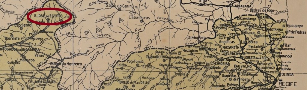
From 1865, this village was called São José das Queimadas, located in the municipality of Ingazeira, about 350 km west of the provincial capital Recife. In May 1872, it ascended to a district called São José da Ingazeira and was granted political autonomy as a municipality five years later. The villa was given the current name São José do Egypto (now Egito) in April 1881.
The local post office was established in 1879, as can be read both in the Imperial Mail Register (Tabella das Agencias do Correio do Imperio, Rio de Janeiro, 1885) and in the Postal Report for 1887. It follows that the first postmark would still have to bear the name São José da Ingazeira. So far, however, only SPE-0560a (Coll. José A. Junges) was found: a double circle with the inscriptions S. JO DO EGYPTO above and (PERNAMO.) below. Two copies are available, both with a date from 1892 in the middle.
Google Maps
Andere Namen: São José das Queimadas, São José da Ingazeira
Diese Ortschaft hieß ab 1865 S. José das Queimadas und lag im Município von Ingazeira, gut 350 km westlich der Provinzhauptstadt Recife. Im Mai 1872 stieg er zum Distrikt von S. José da Ingazeira und erhielt seine politische Autonomie als Município fünf Jahre später. Die dann entstandene Villa erhielt im April 1881 den bis heute aktuellen Namen S. José do Egypto (heute Egito geschrieben).
Villiers de l’Ile Adam: Carta (…) das Provincias de Pernambuco, Alagoas e Sergipe, 1848
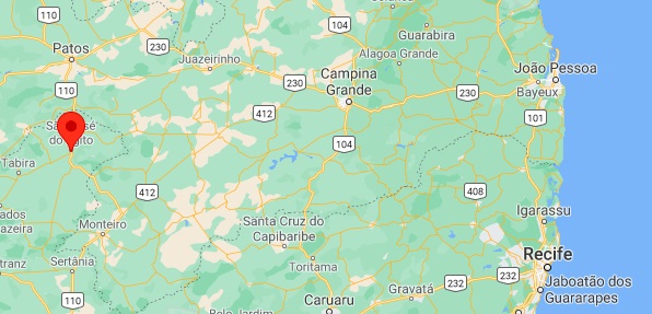
Other names: Coroa Grande, Puirassu
This village was originally a freguesia of Barreiros, located on the beach on the provincial border with Alagoas, about 120 km south of the provincial capital Recife. Later, the place name changed three times: in 1901 to Coroa Grande (= Big Crown), in 1938 to Puirassu (Big Crown in the Tupi language) and in 1958 back to the old Sao José da Coroa Grande, which has been an own municipality since December 1958.
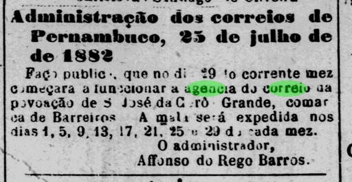
As reported by the regional press, there was a post office there since July 1882:
Diario de Pernambuco, 26 July 1882
So far, no local postmark of the Empire has been found.
Atlas do Imperio do Brasil, 1868
Andere Namen: Coroa Grande, Puirassu
Diese Ortschaft war ursprünglich eine Freguesia von Barreiros, die am Strand an der Provinzgrenze zu Alagoas lag, knapp 120 km südlich der Provinzhauptstadt Recife. Später wechselte der Ortsname – nun als Distrikt – dreimal: 1901 zu Coroa Grande (= Große Krone), 1938 zu Puirassu (Große Krone in der Tupi-Sprache) und 1958 zum alten São José da Coroa Grande zurück, der seit Dezember 1958 ein eigener Município ist.
Wie man in der Regionalpresse lesen kann, gab es dort ein Postamt seit Juli 1882:
Diario de Pernambuco, 26. Juli 1882
Bisher wurde kein Poststempel des Kaiserreichs von dort gesichtet.
From July 1832, this was a freguesia of Barbacena, located on the west bank of the River Chopotó (today written Xopotó), about 110 km south of the provincial capital Ouro Preto. In July 1868, the village passed as a freguesia to the municipality of Piranga and became a villa in its own municipality under the name Alto Rio Doce in March 1890. Since May 1892, Alto Rio Doce has been a town.
Two dates for the creation of the local post office were found. The Imperial Mail Register (Tabella das Agencias do Correio do Imperio) of 1885 indicates the year 1877, while Paula Sobrinho writes October 1887 in his História Postal de Minas Gerais (Belo Horizonte, 1997), which could be a copy error or a reopening date, because there are previous local cancels. SMG 2455a (Coll. José A. Junges) has a double circle with the inscription S. JOSÉ DO CHOPOTÓ above and an ornament in cross below. The dates at the centre are from 1885 to 1886. SMG-2455b (Coll. José A. Junges) came after that: here are the inscriptions in the double circle S. JE. DO CHOPOTÓ above and (MINAS) below, the only copy so far bearing a date from 1889 in the centre.
Villiers de l’Ile Adam: Carta (…) da Provincia de Minas Geraes, 1849
Anderer Name: Alto Rio Doce (1890)
São José do Chopotó war ab Juli 1832 eine Freguesia von Barbacena, die am Westufer des Flusses Chopotó (heute Xopotó geschrieben), ca. 110 km südlich der Provinzhauptstadt Ouro Preto lag. Im Juli 1868 ging der Ort als Freguesia zum Município von Piranga über, und wurde eine Villa im eigenen Município unter dem Namen Alto Rio Doce im März 1890. Seit Mai 1892 ist Alto Rio Doce eine Stadt.
Es wurden zwei Jahre für die Gründung des örtlichen Postamtes gefunden. Das Verzeichnis der kaiserlichen Postämter (Tabella das Agencias do Correio do Imperio) von 1885 gibt das Jahr 1877 an, während Paula Sobrinho den Oktober 1887 in seiner História Postal de Minas Gerais (Belo Horizonte, 1997) schreibt, was ein Kopierfehler oder ein Wiedereröffnungsdatum sein dürfte, da es frühere lokale Stempel gibt. SMG 2455a (Samml. José A. Junges) hat einen Doppelkreis mit der Inschrift S. JOSÉ DO CHOPOTÓ oben und einem Ornament in Kreuz unten. Die Daten in der Mitte gehen von 1885 bis 1886. SMG-2455b (Samml. José A. Junges) kam danach: hier lauten die Inschriften im Doppelkreis S. JE. DO CHOPOTÓ oben und (MINAS) unten, Das bisher einzige Exemplar trägt ein Datum aus 1889 in der Mitte.