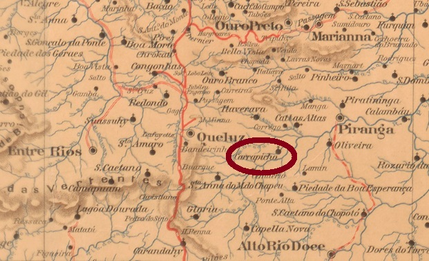
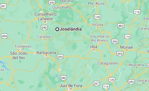
This locality with the strange name (Carrapicho is a plant of the Asteraceae family) became in October 1881 a parish in the Municipality of Queluz, which was located on the west bank of the river Piranga, about 60 km south of the provincial capital Ouro Preto. In December 1953, the place name was changed to Joselândia, and since December 1962 Joselândia is a district in the municipality of Santana dos Montes.
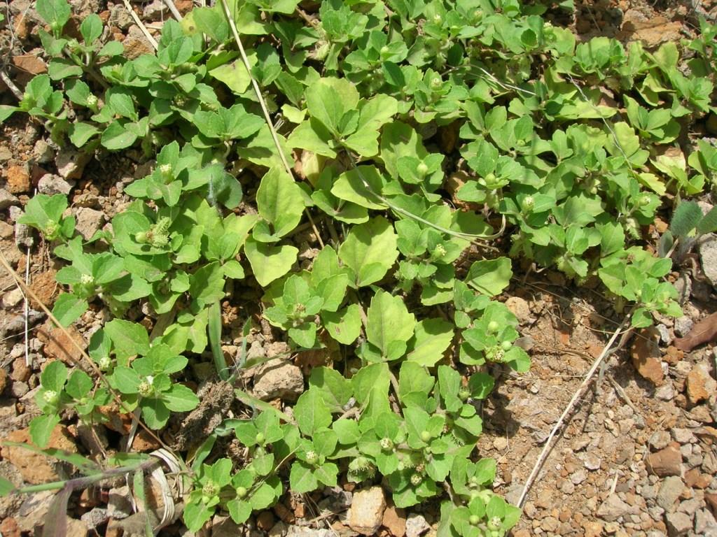
Acanthospermum australe (Photo: Forrest & Kim Starr)
According to Paula Sobrinho (História Postal de Minas Gerais, Belo Horizonte, 1997), the local post office was established in June 1887. The only postmark of the 19th century was sighted with earliest date from 1895. SMG-2450a (Coll. José A. Junges) has a double circle with the inscriptions S. JE DO CARRAPICHO above and (MINAS) below, with date at the centre.
Google Maps
Andere Namen: Carrapicho, Joselândia (1953)
Diese Gemeinde mit dem merkwürdigen Namen (Carrapicho ist eine Pflanze der Familie Asteraceae) wurde im Oktober 1881 eine Pfarrei im Município von Queluz, die am Westufer des Flusses Piranga, gut 60 km südlich der Provinzhauptstadt Ouro Preto entfernt lag. Im Dezember 1953 wurde der Ortsname zu Joselândia geändert, und seit Dezember 1962 ist Joselândia ein Distrikt im Município von Santana dos Montes.
Acanthospermum australe (Foto: Forrest & Kim Starr)
Laut Paula Sobrinho (História Postal de Minas Gerais, Belo Horizonte, 1997) entstand das örtliche Postamt im Juni 1887. Der bisher einzige Poststempel des 19. Jahrhunderts wurde mit frühestem Datum aus 1895 gesichtet. SMG-2450a (Samml. José A. Junges) hat einen Doppelkreis mit den Inschriften S. JE DO CARRAPICHO oben und (MINAS) unten, dazu Datum in der Mitte.
Other names: São José do Parahyba, S. José do Norte
There were apparently two neighbouring villages, which later merged. Since July 1767, there was a villa called S. José do Parahyba, which was located on the river of the same name, about 90 km northeast of the later provincial capital of São Paulo. Just over a year later, a freguesia of São José dos Campos was founded in the neighbourhood, still within the municipality of Jacarehy. In April 1864, the village of São José da Parahyba became a town through merging with S. José dos Campos and had been bearing the latter name since April 1871.
There are still many questions about the postal history of this village. Nova Monteiro writes in Administrações e Agencias Postaes do Brasil Imperio (Brasil Filatelico/RJ, 1934-5; Reprint SPP 1994-1999) that the local post office was only established in October 1849, although the presence of Bull’s Eyes issued in 1843 with this local cancel would speak for an earlier date. The philatelist Mario Celso R. Orsi Jr. reports an agency creation exactly with same day and month, but in 1834 and without naming his source. SSP-1855a is also found in brown colour and has already been introduced by Henrique B. Ferreira in his Catalogo ilustrado dos carimbos sobre os olhos-de-boi (Porto Alegre, 2017):
SSP-1855a (HBF S17) 1843ff-1858ff
Given that the next cancel was only registered after about 20 years, one wonders whether there would exist an unknown cancel, the agency was closed for a while, or both. SSP-1190a (Coll. José A. Junges) is also available in blue and sepia, and it has a double circle with the inscription S. J. DOS CAMPOS above. The internal dates originate from the period 1879-1886. SSP-1190b (Coll. FM) is a “French type”: a double circle with the inscription S. J. DOS CAMPOS above and the typical star in brackets below. Dates inside: 1884-1893.
The next question relates to the local station. It was inaugurated in August 1876, and in the Imperial Postal Guide (Guia Postal do Imperio) for 1880 a station post office S. José dos Campos is listed under no. 402. Accordingly, there was still a previously unknown station cancel, or maybe this would be SSP-1190a… The same guide also lists under No. 1027 another post office in São Paulo, which is called S. José do Norte. Since S. José do Norte was also a name for S. José dos Campos, this could mean that there were two post offices there, which would be quite unlikely. There are still many issues for researching.
Villiers de l’Ile Adam: Carta (…) da Provincia de São Paulo, 1847
Andere Namen: São José do Parahyba, S. José do Norte
Hier handelt es sich scheinbar um zwei benachbarte Ortschaften, die später fusionierten. Es gab seit Juli 1767 eine Villa namens S. José do Parahyba, die am gleichnamigen Fluss, ca. 90 km nordöstlich der späteren Provinzhauptstadt São Paulo lag. Gut ein Jahr später wurde die Freguesia von São José dos Campos in der Nachbarschaft gegründet, doch noch der Gemeinde Jacarehy zugeordnet war. Im April 1864 wurde aus São José da Parahyba eine Stadt, die mit S. José dos Campos zusammen kam und seit April 1871 letzteren Namen trägt.
Weil der nächste Stempel erst nach ca. 20 Jahren registriert wurde, fragt man sich, ob es noch einen unbekannten Stempel gibt, die Agentur für eine Weile geschlossen wurde, oder beides. SSP-1190a (Samml. José A. Junges) gibt es auch in Blau und Sepia, und er hat einen Doppelkreis mit der Inschrift S. J. DOS CAMPOS oben. Die inneren Daten entstammen dem Zeitraum 1879-1886. SSP-1190b (Samml. FM) ist ein „französischen Typus“: ein Doppelkreis mit der Inschrift S. J. DOS CAMPOS oben und dem typischen Stern in Klammern unten. Daten im Inneren: 1884-1893.
Die nächste Frage bezieht sich auf den Bahnhof vor Ort. Er wurde im August 1876 eingeweiht, und im kaiserlichen Postführer (Guia Postal do Imperio) für 1880 wird ein Bahnhofspostamt S. José dos Campos unter Nr. 402 aufgelistet. Demnach gab es noch einen bisher unbekannten Bahnhofsstempel, oder wäre es SSP-1190a… Derselbe Führer listet außerdem unter der Nr. 1027 ein weiteres Postamt in São Paulo, der S. José do Norte heißt. Da S. José do Norte auch ein Name für S. José dos Campos war, könnte es bedeuten, dass es dort zwei Postämter gab, was ziemlich unwahrscheinlich wäre. Hier besteht noch viel Klärungsbedarf.
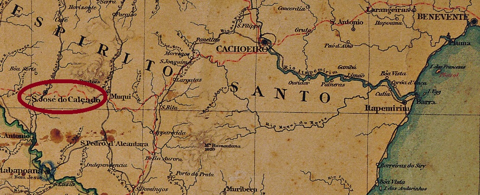
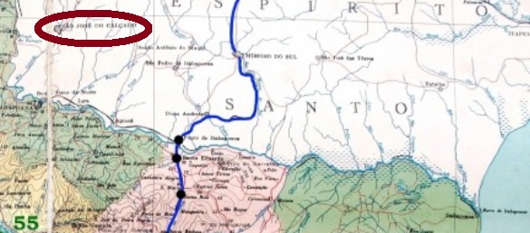
This village, with a strange name related to shoes (calçado), was a district of S. Pedro do Itabapoanna, located about 240 km southwest of the provincial capital Vitória, on the border with the province of Rio de Janeiro. In November 1890, the village became a municipality. Since the footwear of the name has no plausible explanation, sometime later a legend with a religious background was invented.
According to Paulo Novaes (agenciaspostais.com.br) there has been a post office there since May 1881. Two early postmarks in double circle were found. SES-0145a (Coll. José A. Junges) also occurs in turquoise and carmine; it has on top the inscription S. JOSÉ DO CALÇADO and below an ornament in diamond, which consists of four small diamonds. Dates at the centre from 1883 until 1889. SES-0145b (Coll. José A. Junges) now has the inscription above S. JE. DO CALÇADO and below (ESP. SANTO). The dates inside go from 1890 to 1902.
agenciaspostais.com.br
Diese Ortschaft mit dem merkwürdigen Namen do Calçado (etwa: vom Schuhwerk) war ab November 1871 ein Distrikt von S. Pedro do Itabapoanna, der ca. 240 km südwestlich der Provinzhauptstadt Vitória entfernt lag, an der Grenze zur Provinz Rio de Janeiro. Im November 1890 stieg der Ort zum Município auf. Das Schuhwerk vom Namen hat bisher keine plausible Erklärung, also wurde irgendwann später eine Legende mit religiösem Hintergrund erfunden.
Laut Paulo Novaes (agenciaspostais.com.br) gibt es dort ein Postamt seit Mai 1881. Zwei frühe Poststempel in Doppelkreis wurden gefunden. SES-0145a (Samml. José A. Junges) kommt auch in türkisblau und karmin vor und hat oben die Inschrift S. JOSÉ DO CALÇADO und unten ein Ornament in Raute, das aus vier kleinen Rauten besteht. Daten in der Mitte: 1883-1889. SES-0145b (Samml. José A. Junges) hat oben nun die Inschrift S. JE. DO CALÇADO und unten (ESP. SANTO). Die Daten im Inneren gehen von 1890 bis 1902.
Other names: São José do Parnahyba, Flores (1890), Timon (1943)
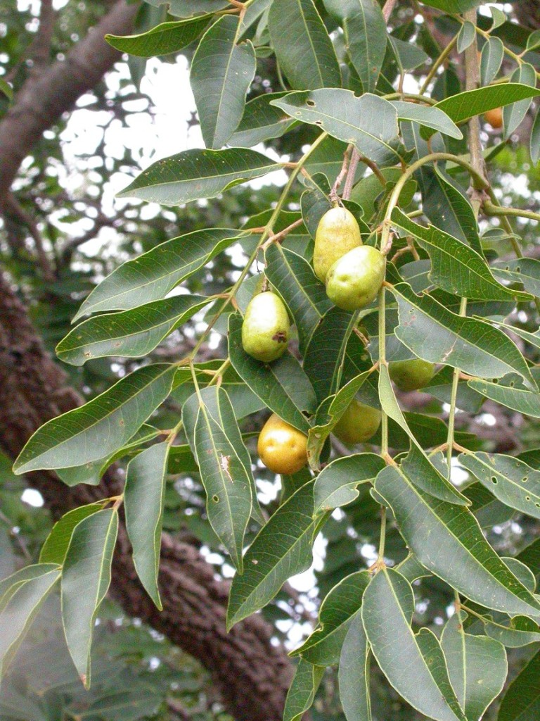
In the first half of the 19th century, São José das Cajazeiras (also spelled Cajaseiras) was a freguesia of S. José dos Matões, located directly on the west bank of the Parnaiba River, on the opposite bank to Teresina, capital of Piauí – more than 400 km southeast of the capital, São Luís do Maranhão. Cajazeira is the yellow mombin plum (Spondiasmombin, Linné 1753), a genus of the sumach family (Anacardiaceae):
Photo: Marco Schmidt (CC BY-SA 2.5)
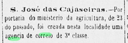
São José das Cajazeiras was the headquarters of the municipality for a short time (1864-1870) but did not rise to the Villa of Flores until December 1890, and in April 1924 became a city called Timon since December 1943. The last name comes from Timon of Athens, a misanthrope of Greek antiquity, whose legendary vita inspired several works of world literature, including Lukian, Shakespeare and Moliére.
The local post office was established in September 1881, as can be seen from the regional press:
O Paiz, 15 October 1881
So far, no postmark of the imperial era could be found from this place.
Carta da Republica dos Estados Unidos do Brazil, 1892
Andere Namen: São José do Parnahyba, Flores (1890), Timon (1943)
São José das Cajazeiras (auch Cajaseiras geschrieben) war in der ersten Hälfte des 19. Jahrhunderts eine Freguesia von S. José dos Matões, die am Westufer des Flusses Parnaiba lag – und auch direkt gegenüber Teresina, der Hauptstadt von Piauí – über 400 km südöstlich der Hauptstadt São Luís do Maranhão entfernt. Cajazeira ist die Gelbe Mombinpflaume (Spondias mombin, Linné 1753), eine Gattung der Sumachgewächse (Anacardiaceae):
Foto: Marco Schmidt (CC BY-SA 2.5)
São José das Cajazeiras war kurzzeitig (1864-1870) Hauptsitz der Gemeinde, stieg aber erst im Dezember 1890 zur Villa von Flores auf, und wurde im April 1924 eine Stadt, die seit Dezember 1943 Timon heißt. Der letzte Name kommt von Timon von Athen, einem Misanthropen der griechischen Antike, dessen legendäre Vita mehrere Werke der Weltliteratur inspirierte, u.a. von Lukian, Shakespeare und Molière.
Das örtliche Postamt entstand im September 1881, wie aus der Regionalpresse hervorgeht:
O Paiz, 15. Oktober 1881
Bisher konnte kein Poststempel der Kaiserzeit aus diesem Ort gefunden werden.
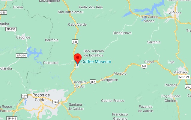
São José dos Botelhos was from October 1866 a district of Cabo Verde, located almost 500 km southwest of the provincial capital Ouro Preto. It changed the municipality twice: in December 1873 to Caldas and in November 1878 back to Cabo Verde. Since August 1911, the village has had its own municipality, whose name was simplified to Botelhos in September 1923, which has the town status since September 1925. Botelho was the name of the first settler family in the area.
As Paula Sobrinho reports in his Historia Postal de Minas Gerais (Belo Horizonte, 1997), there has been a post office there since November 1874. Two early postmarks in double circle from there were found, but probably not the oldest of them, since all the dates are Republican. SMG-2405b (image from the Internet) bears the inscription S. JE. DOS BOTELHOS above and (MINAS) below; it was found with inner dates between 1896 and 1904. At SMG-2405c (Coll. José A. Junges) is the upper inscription, on the other hand, S. JOSÉ DOS BOTELHOS. The only copy so far is dated 1906 inside.
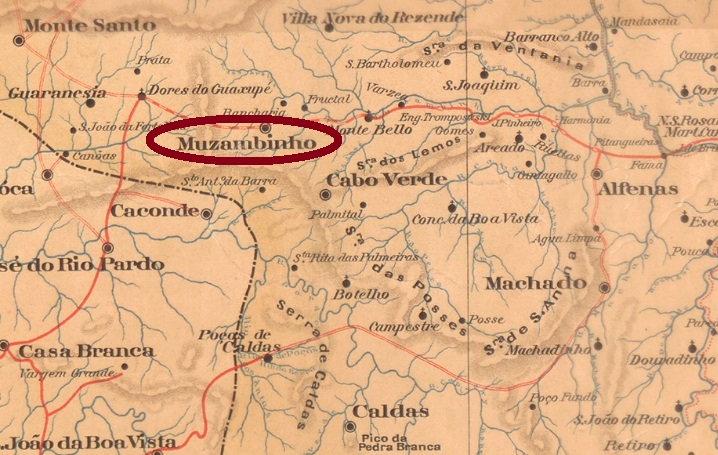
Google Maps
Anderer Name: Botelhos (1923)
São José dos Botelhos war ab Oktober 1866 ein Distrikt von Cabo Verde, der fast 500 km südwestlich der Provinzhauptstadt Ouro Preto entfernt lag. Er wechselte danach zweimal die Zuständigkeit: im Dezember 1873 zu Caldas und im November 1878 zurück nach Cabo Verde. Seit August 1911 hat die Ortschaft einen eigenen Município, dessen Name im September 1923 zu Botelhos vereinfacht wurde, und Botelhos nennt sich auch seit September 1925 eine Stadt. Botelho hieß die erste Siedlerfamilie der Gegend.
Wie Paula Sobrinho in seiner Historia Postal de Minas Gerais (Belo Horizonte, 1997) berichtet, gibt es dort seit November 1874 ein Postamt. Zwei frühe Poststempel im Doppelkreis von dort wurden gefunden, aber wahrscheinlich nicht der älteste davon, da alle Daten republikanisch sind. SMG-2405b (Abb. aus dem Internet) trägt oben die Inschrift S. JE. DOS BOTELHOS und unten (MINAS); er wurde mit Daten im Inneren zwischen 1896 und 1904 gefunden. Bei SMG-2405c (Samml. José A. Junges) lautet die Inschrift oben dagegen S. JOSÉ DOS BOTELHOS. Das einzige Exemplar ist 1906 in der Mitte datiert.
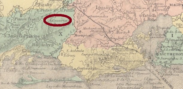
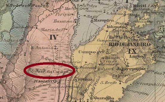
This village was called originally São Jozé da Cacaria, a freguesia of São João do Principe (see SRJ-0945), which was located about 80 km northwest of the imperial capital Rio de Janeiro. In 1875 the toponym changed to the better sounding S. José do Bom Jardim. In December 1890, following the social, political, and economic downfall of S. João do Principe, S. José do Bom Jardim passed as a district to the municipality of Pirahy. And this status remained to this day, although the district has been called Monumento since December 1938.
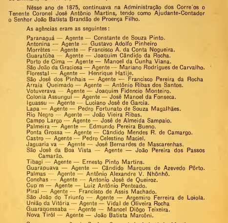
The postal agency of São José da Cacaria was created in August 1856, according to Nova Monteiro in Administrações e Agencias Postaes do Brasil Imperio (Brasil Filatelico/RJ, 1934-5; Reprint SPP 1994-1999). This can be ratified by Aureo G. Santos in Agências de Correio Criadas e Suprimidas 1851, 1855, 1856 e 1857 (Brasil Filatélico 181, Rio de Janeiro, 1977):
Aureo G. Santos (op. cit.)
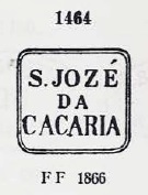
The oldest cancel there, SRJ-0950a, which also occurs in violet, was used at least until 1875 and has already been presented by Paulo Ayres in Catálogo de Carimbos Brasil-Império (S. Paulo, 1937, 1942), under # 1463:
SRJ-0950a (P. Ayres 1463, MPT 379) 1856-1875ff
We can assume that the post office of S. José da Cacaria has continued to operate from 1875 under the new toponym S. José do Bom Jardim, since this year can be read as the year of its creation in the Imperial Mail Register (Tabella das Agencias do Correio do Imperio, Rio de Janeiro, 1885). Two imperial postmarks in double circle were to be found. SRJ-1440a (Coll. José A. Junges) simply bears the inscription S. J. DO BOM JARDIM above. The only seen copy is dated 1884 in the centre. SRJ-1440b (Coll. Paulo Novaes) now has the inscription S. JOSÉ DO BOM-JARDIM above and a hollow-cross ornament below. Dates inside: 1889 and 1890.
Villiers de l’Ile Adam: Carta (…) da Provincia do Rio de Janeiro, 1850
Anderer Name: Monumento (1938)
São José da Cacaria war eine Freguesia von São João do Príncipe (siehe SRJ-0945), die ca. 80 km nordwestlich der kaiserlichen Hauptstadt Rio de Janeiro entfernt lag. Dieser Name klingt sehr merkwürdig auf Portugiesisch (ein Caco ist eine Scherbe), daher wundert es nicht, dass er 1875 zu S. José do Bom Jardim geändert wurde. Mit dem sozialen, politischen und wirtschaftlichen Untergang von S. João do Principe ging S. José do Bom Jardim im Dezember 1890 als Distrikt zum Município von Pirahy über. Und so blieb es bis heute, wenngleich der Distrikt seit Dezember 1938 Monumento heißt.
Die älteste Abstempelung dort, SRJ-0950a, verwendet bis mindestens 1875, kommt auch in violett vor und wurde uns bereits von Paulo Ayres in Catálogo de Carimbos Brasil-Império (S. Paulo, 1937, 1942) unter Nummer 1463 präsentiert:
SRJ-0950a (P. Ayres 1463, MPT 379) 1856-1875ff
Wir dürfen annehmen, dass das seit August 1856 bestehende Postamt von S. José da Cacaria ab 1875 unter dem neuen Ortsnamen S. José do Bom Jardim weiter geführt wurde, da diese Jahresangabe als Entstehungsjahr dieser Agentur im Verzeichnis der kaiserlichen Postämter (Tabella das Agencias do Correio do Imperio, Rio de Janeiro, 1885) zu lesen ist. Zwei imperiale Poststempel in Doppelkreis waren zu finden. SRJ-1440a (Samml. José A. Junges) trägt einfach die Inschrift S. J. DO BOM JARDIM oben. Das einzig vorhandene Exemplar ist mit 1884 in der Mitte datiert. SRJ-1440b (Samml. Paulo Novaes) hat nun die Inschrift S. JOSÉ DO BOM-JARDIM oben und ein ausgehöhltes Ornament in Kreuz unten. Daten in der Mitte: 1889 und 1890.
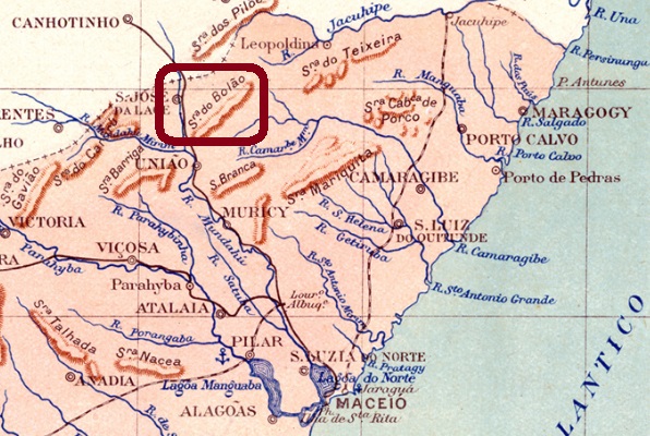
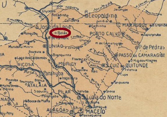
Here is another village that has disappeared from the map today. In 1871 it became a freguesia from Villa da Imperatriz, which was located about 120 km north of the provincial capital Maceió. In September 1890, it was transferred as a district to the newly founded municipality of União dos Palmares. The 1920 census still recorded a local population of more than 13 thousand, but a health disaster must have occurred afterwards, which displaced the population. Today, only the name Serra do Bolão has remained: a low mountain range near União dos Palmares.
As Aldo Cardoso writes in his Contribuição para a História dos Correios de Alagoas (Maceió, 1969), there has been a post office there since July 1885. So far, no 19th-century postmark has been seen. Aldo Cardoso (op. cit.) mentions a local cancel on an 1894 issue, unfortunately without providing images.
Arthur D. Ribeiro: Mappa do Estado de Alagoas, 1924
Anderer Name: Bolão
Hier ist wieder eine Ortschaft, die heute aus der Landkarte verschwunden ist. Sie wurde 1871 eine Freguesia von der Villa da Imperatriz, die ca. 120 km nördlich der Provinzhauptstadt Maceió lag. Im September 1890 ging sie als Distrikt zum neu gegründeten Município von União dos Palmares über. Der Zensus von 1920 ergab noch eine Ortsbevölkerung von über 13 Tausend Einwohner, aber es muss danach eine sanitäre Katastrophe eingetreten sein, die die Bevölkerung vertrieben hat. Heute ist lediglich der Name Serra do Bolão ein Begriff: ein Mittelgebirge bei União dos Palmares.
Wie Aldo Cardoso in seiner Contribuição para a História dos Correios de Alagoas (Maceió, 1969) schreibt, gab es dort ein Postamt seit Juli 1885. Bisher war kein Poststempel des 19. Jahrhunderts zu sehen. Aldo Cardoso (op. cit.) erwähnt einen Ortstempel auf einer Ausgabe von 1894, leider ohne Abbildung.
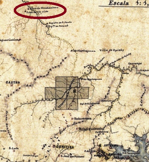
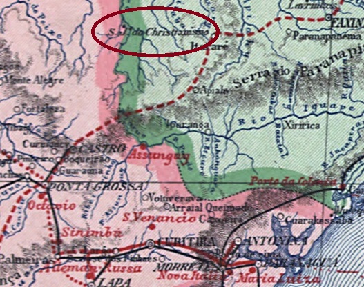
This place was the former freguesia of São José do Christianismo, which was founded in April 1870, located on the east bank of the river Pescaria (=Fishing), 300 km north of the provincial capital Curitiba. In March 1876, it was elevated to the villa of São José da Boa Vista and in December 1897 to a town.
As can be read in the Imperial Mail Register (Tabella das Agencias do Correio do Imperio) of 1885, there is a post office there since 1876. However, the agency may have been older, as a postal worker was reported for 1875:
F. Pereira & J. Oliveira Fo.: Subsídios (…) de Correios e Telégrafos, 1938
A postmark was found in the Empire, but its assignment is not entirely certain. SPR-0190b (Coll. Marcio Protzner) has a double circle with the inscription S. JOSÉ DA BOA VISTA. Both seen copies have dates from 1889 inside.
Carta da Republica dos Estados Unidos do Brazil, 1892
Anderer Name: São José do Christianismo
Dieser Ort war die frühere Freguesia von São José do Christianismo, die im April 1870 gegründet wurde, und am Ostufer des Flusses Pescaria (Fischerei), 300 km nördlich der Provinzhauptstadt Curitiba lag. Im März 1876 wurde er zur Villa von São José da Boa Vista und im Dezember 1897 zur Stadt erhoben.
F. Pereira & J. Oliveira Fo.: Subsídios (…) de Correios e Telégrafos, 1938
Ein Poststempel im Kaiserreich wurde gefunden, dessen Zuordnung allerdings nicht vollkommen sicher ist. SPR-0190b (Samml. Marcio Protzner) hat einen Doppelkreis mit der Inschrift S. JOSÉ DA BOA VISTA. Beide Exemplare haben Daten aus 1889 in der Mitte.
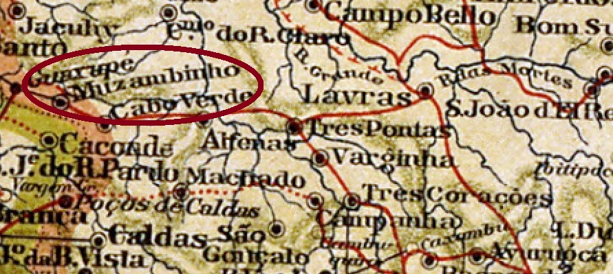
See also Muzambinho (R. Koester: Carimbologia XXVII)
From January 1866, São José da Boa Vista was a district of Cabo Verde, located on the east bank of the Muzambinho River, more than 450 km west of the provincial capital Ouro Preto. In November 1878, the village became a villa called Muzambinho, which was elevated to a town two years later.
Both Paula Sobrinho (Historia Postal de Minas Gerais, Belo Horizonte, 1997) and Reinhold Koester (Carimbologia XXVII) agree that the local post office was created in January 1875. Until now, no imperial cancel could be assigned to this place with certainty.
Mappa de Minas Geraes, 1911
Siehe auch Muzambinho (R. Koester: Carimbologia XXVII)
São José da Boa Vista war ab Januar 1866 ein Distrikt von Cabo Verde, der am Ostufer des Flusses Muzambinho lag, über 450 km westlich der Provinzhauptstadt Ouro Preto entfernt. Im November 1878 stieg der Ort zu einer Villa, die Muzambinho hieß und zwei Jahre später zur Stadt erhoben wurde.
Sowohl Paula Sobrinho (Historia Postal de Minas Gerais, Belo Horizonte, 1997) als auch Reinhold Koester (Carimbologia XXVII) sind sich darüber einig, dass das örtliche Postamt im Januar 1875 entstand. Bisher konnte kein kaiserlicher Stempel mit Sicherheit diesem Ort zugeordnet werden.
Villiers de l’Ile Adam: Carta (..) da Provincia do Rio de Janeiro, 1850
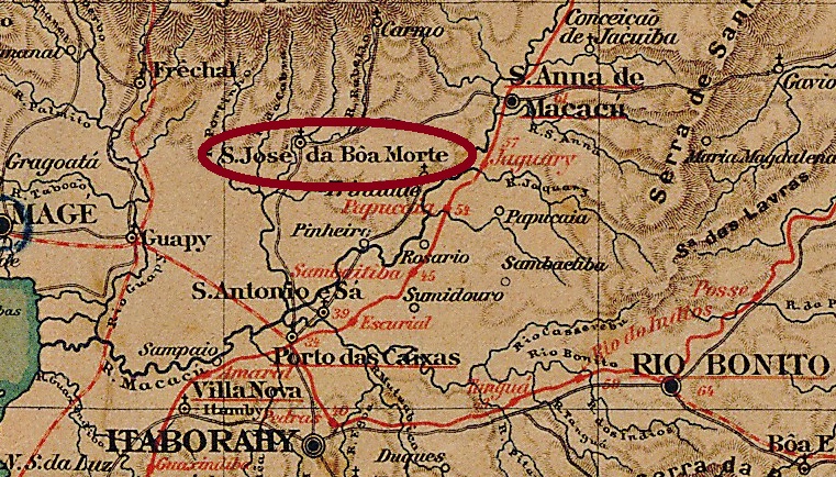
Another name: São José
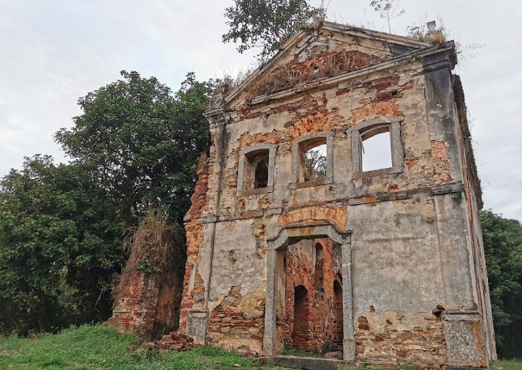
São José da Boa Morte (= of the Good Death) was from 1837 a freguesia in the municipality of Santo Antonio de Sá, located about 100 km northeast of Rio de Janeiro. At that time, a devastating and long-standing malaria epidemic caused an unstoppable decline of Santo Antonio. After its end in November 1868, the town of São José was transferred to the newly founded municipality of Sant’Anna de Macacu, which from December 1898 was called Sant’Anna de Japuíba. Since March 1938, this municipality has been called Cachoeiras de Macacu, of which Sao José is a rural suburb, whose main attraction is the ruins of the old chapel.
In 2019 (Photo: Claudio Menezes)
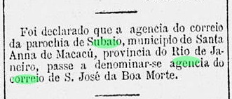
According to Paulo Novaes (agenciaspostais.com.br), there was a post office in São José da Boa Morte from June 1887 to September 1914. However, this agency was probably located in the neighbouring Subaio, as can be read in the Rio press:
Gazeta de Noticias, 21 July 1887
The only cancel so far to be attributed to this agency is SRJ-0948a (Coll. Paulo Novaes): a double circle with the inscriptions S JE. DA BÔA MORTE above and (PROVA. DO RIO) below. Copies were seen with dates of 1894 and 1895 inside.
Almanak Laemmert, 1892
Anderer Name: São José
São José da Boa Morte (= des guten Todes) war ab 1837 eine Freguesia im Município von Santo Antonio de Sá, die ca. 100 km nordöstlich von Rio de Janeiro lag. Zu dieser Zeit befand sich Santo Antonio de Sá durch eine verheerende und langjährige Malaria-Epidemie bereits in einem Niedergang, der nicht mehr aufzuhalten war. Nach dessen Ende im November 1868 ging São José zum neu gegründeten Município von Sant’Anna de Macacu über, der ab Dezember 1898 Sant’Anna de Japuíba hieß. Seit März 1938 trägt dieser Município den Namen Cachoeiras de Macacu; davon ist São José ein ländlicher Vorort, dessen Hauptattraktion die Ruinen der alten Kapelle sind.
In 2019 (Foto: Claudio Menezes)
Laut Paulo Novaes (agenciaspostais.com.br) gab es ein Postamt São José da Boa Morte vom Juni 1887 bis September 1914. Allerdings lag diese Agentur wohl in der Nachbargemeide Subaio, wie aus der Rio-Presse zu entnehmen ist:
Gazeta de Noticias, 21 Juli 1887
Der einzige Stempel bisher mit Sicherheit dieser Agentur zuzuordnen ist SRJ-0948a (Samml. Paulo Novaes): ein Doppelkreis mit den Inschriften S JE. DA BÔA MORTE oben und (PROVA. DO RIO) unten. Gesehen mit Daten von 1894 und 1895 in der Mitte.