Categories
Carimbologia S

São João do Paraizo, Rio de Janeiro (SRJ-1400)

agenciaspostais.com.br

Another name: Paraisinho (1938-1947)

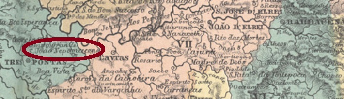
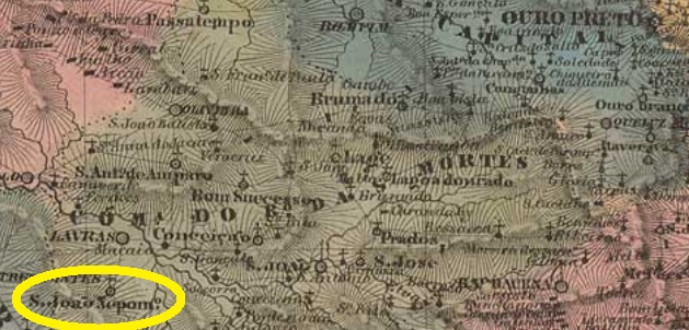
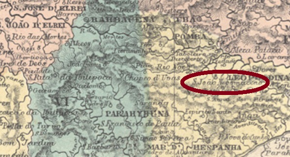
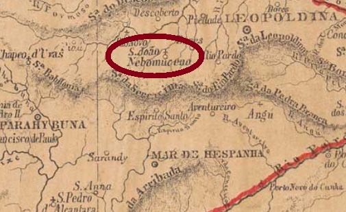
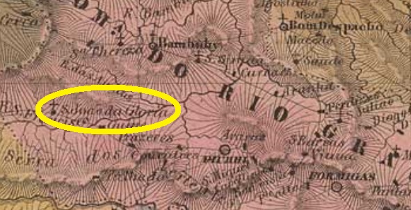
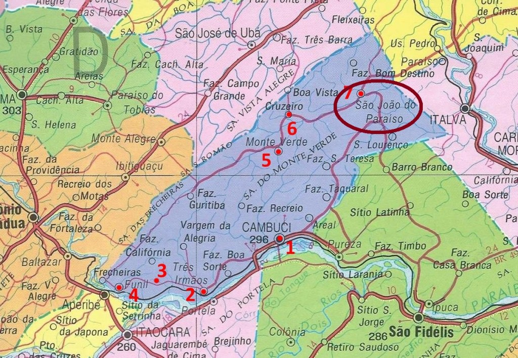
São João do Paraizo (later written Paraiso) was a settlement near São Fidelis, about 340 km northeast of the imperial capital of Rio de Janeiro. In November 1879, the town passed as a district to the municipality of Monte Verde, and in December 1938 – now under the toponym Paraisinho – to the then newly founded municipality of Cambuci. It remained so to this day, although the earlier name returned in June 1947.

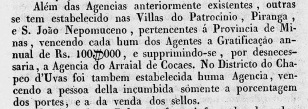
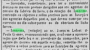
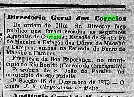
The local post office was created in December 1875, as can be read in the Rio press:

O Globo, 17 December 1875

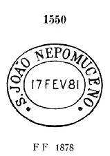
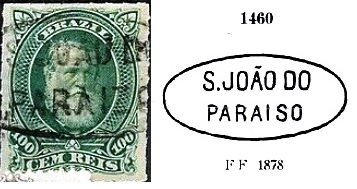
Two postmarks of the imperial period have been found. The first one, SRJ-1400a, was in use at least until 1878 and already made known by Paulo Ayres (Catálogo de Carimbos Brasil-Império, S. Paulo, 1937, 1942) under No. 1460, although PARAISO was mistakenly written with S here:

SRJ-1400a (P.A. 1460 recte), 1875-1878ff

It was followed by SRJ-1400b (image from the Internet): a simple double circle with the inscription S. J. DO PARAISO above. The dates in the centre have been found so far for the period 1881-1897.

ca.1940, Photo Halleypo (CC 3.0)

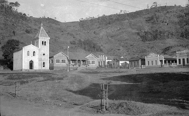
Anderer Name: Paraisinho (1938-1947)

São João do Paraizo (später Paraíso geschrieben) war eine Siedlung bei São Fidelis, die gut 340 km nordöstlich der kaiserlichen Hauptstadt Rio de Janeiro entfernt lag. Im November 1879 ging der Ort als Distrikt zum Município von Monte Verde über, und im Dezember 1938 – nun unter dem Ortsnamen Paraisinho – zum damals neu gegründeten Município von Cambuci. Dabei blieb es bis heute, wenngleich der alte Name São João do Paraíso im Juni 1947 zurückkehrte.

Das örtliche Postamt wurde im Dezember 1875 gegründet, wie aus der Rio-Presse zu entnehmen ist:

O Globo, 17. Dezember 1875

Zwei Poststempel der Kaiserzeit sind überliefert. Der erste, SRJ-1400a, war zumindest bis 1878 im Gebrauch und wurde bereits durch Paulo Ayres (Catálogo de Carimbos Brasil-Império, S. Paulo, 1937, 1942) unter Nr. 1460 bekannt gemacht, obwohl hier irrtümlicherweise PARAISO mit S geschrieben wurde:

SRJ-1400a (P.A. 1460 recte), 1875-1878ff

Ihm folgte SRJ-1400b (Abb. aus dem Internet): ein schlichter Doppelkreis mit der Inschrift S. J. DO PARAISO oben. Die Daten in der Mitte wurden bisher für den Zeitraum 1881-1897 gefunden.

Categories
Carimbologia S

São João Nepomuceno de Lavras, Minas Gerais, (SMG-2405)

Atlas do Imperio do Brasil, 1868

Another name: Nepomuceno (1911)

This second Saint John of Nepomuk in the province of Minas Gerais was a district of Lavras, about 280 km southwest of the provincial capital Ouro Preto. It was not until August 1911 that it became a villa in its own municipality, which has since been called Nepomuceno, probably to avoid confusion with the other place of same name (SMG-2400).

As Paula Sobrinho (História Postal de Minas Gerais, Belo Horizonte, 1997) tells us, there has been a post office there since May 1887. The only cancel of the 19th century from there shows Republican years but is probably the oldest one. SMG-2405a (image from the Internet) is a double circle with the inscriptions S. Jo. NEPOMUCENO DE LAVRAS above and (MINAS) below. All three existing copies have upside down dates (between 1895 and 1896) at the centre. 

Villiers de l’Ile Adam: Carta (…) da Provincia de Minas Geraes, 1849

Anderer Name: Nepomuceno (1911)

Dieser zweiter Sankt Nepomuk in der Provinz Minas Gerais war seit September 1831 ein Distrikt von Lavras, der gut 280 km südwestlich der Provinzhauptstadt Ouro Preto lag. Erst im August 1911 wurde daraus eine Villa im eigenen Município, der seitdem Nepomuceno heißt, wohl um Verwechslungen mit dem anderen Ort gleichen Namens (SMG-2400) zu vermeiden.

Wie uns Paula Sobrinho (História Postal de Minas Gerais, Belo Horizonte, 1997) mitteilt, gibt es dort ein Postamt seit Mai 1887. Der bisher einzige Stempel des 19. Jahrhunderts von dort zeigt zwar republikanische Jahre, dürfte aber der erste sein. SMG-2405a (Abb. aus dem Internet) ist ein Doppelkreis mit den Inschriften S. Jo. NEPOMUCENO DE LAVRAS oben und (MINAS) unten. Alle drei vorhandenen Exemplare haben kopfstehende Daten (zwischen 1895 und 1896) in der Mitte.  

Categories
Carimbologia S

São João Nepomuceno, Minas Gerais (SMG-2400)

Atlas do Imperio do Brasil, 1868

From November 1815, São João Nepomuceno was a freguesia that belonged to Pomba, about 250 km south of the later provincial capital Ouro Preto. In April 1841, it was elevated to a district, and ten years later, the district passed to the municipality of Mar d’Hespanha. The locality rose to a villa in July 1868, but two years later it was demoted to a district of Rio Novo. It remained so until November 1880, when the town was elevated again to villa, now in its own municipality.

Paula Sobrinho writes in his Historia Postal de Minas Gerais (Belo Horizonte, 1997) that the local post office was not established until February 1878. This is certainly a reopening, however, because already in the Ministerial Report of May 1844 a new post office in São João Nepomuceno was mentioned, which had probably been set into operation the previous year:

Relatorio do Ministerio do Imperio for 1843, May 1844

Since this post town was still listed in the Courier Route Guide (Roteiro de Correios Terrestres) for August 1856, but was already absent in the Imperial Postal Guide (Guia do Correio do Brazil) for 1857, we can assume that the agency was closed in between.

All three early cancels date from the second operating period. SMG-2400b was found with dates between 1879 and 1889 and has already been presented by Paulo Ayres (Catalogo de Carimbos Brasil-Império, S. Paulo, 1937, 1942) under No. 1550:

SMG-2400b (P. Ayres #1550)

It was followed by SMG-2400c (Coll. José A. Junges): a double circle with the inscription S. JOĀO NEPOMOCENO (sic) above and an ornament in cross form below. Dates inside: 1886-1888. The spelling error will probably be the reason why its predecessor remained in use. The last cancel SMG-2400d (image from the Internet) bears the inscriptions C.S. Jo. NEPOMUCENO above and (MINAS) below, with dates inside from 1891 and 1892.

Provincia de Minas Geraes 1873

São João Nepomuceno war ab November 1815 eine Freguesia von der Gemeinde Pomba, die ca. 250 km südlich der späteren Provinzhauptstadt Ouro Preto lag. Im April 1841 stieg sie zum Distrikt auf, zehn Jahre später wechselte der Distrikt zum Município von Mar d’Hespanha. Dann stieg der Ort zu einer Villa im Juli 1868 auf, aber schon zwei Jahre später wurde er zum Distrikt von Rio Novo degradiert. So blieb es bis November 1880, als São João Nepomuceno abermals zur Villa aufstieg, nun im eigenen Município.

Paula Sobrinho schreibt in seiner Historia Postal de Minas Gerais (Belo Horizonte, 1997), dass das örtliche Postamt erst im Februar 1878 entstanden ist. Das ist aber sicherlich eine Wiedereröffnung, denn bereits im Ministerialbericht vom Mai 1844 war von einem neuen Postamt in São João Nepomuceno die Rede, das wohl im Vorjahr in Betrieb genommen worden war:

Relatorio do Ministerio do Imperio für 1843, Mai 1844

Da dieser Postort im Verzeichnis der Stafettenruten (Roteiro de Correios Terrestres) für August 1856 noch aufgelistet, aber im Kaiserlichen Postführer (Guia do Correio do Brazil) für 1857 nicht mehr zu lesen war, können wir annehmen, dass die Agentur zwischendurch geschlossen wurde.

Alle drei frühen Stempel stammen aus der zweiten Betriebsperiode. SMG-2400b wurde mit Daten zwischen 1879 und 1889 gefunden und wurde bereits durch Paulo Ayres (Catálogo de Carimbos Brasil-Império, S. Paulo, 1937, 1942) unter Nr. 1550 bekannt gemacht:

SMG-2400b (P. Ayres 1550)

Ihm folgte SMG-2400c (Samml. José A. Junges): ein Doppelkreis mit der Inschrift S. JOĀO NEPOMOCENO (sic) oben und einem Ornament in Kreuzform unten. Daten in der Mitte: 1886-1888. Der Schreibfehler wird wohl der Grund sein, warum sein Vorgänger weiterhin in Gebrauch blieb. Der letzte Stempel SMG-2400d (Abb. aus dem Internet) trägt im Doppelkreis die Inschriften C.S. Jo. NEPOMUCENO oben und (MINAS) unten, mit Daten in Inneren von 1891 und 1892.

Categories
Carimbologia S

São João do Morro Grande, Minas Gerais (SMG-2385)

Atlas do Imperio do Brasil, 1868

Other names: Morro Grande, Barão de Cocais (1943)

Founded in January 1752 near Santa Barbara, the parish of Sao João Baptista do Morro Grande was located directly on the Santa Barbara River, about 80 km north of the later provincial capital Ouro Preto. In April 1926 it became a district, which in December 1938 was given the simplified name Morro Grande. Political autonomy came in December 1943, and the new municipality was henceforth called Barão de Cocais. This baron (1802-1869) was a famous son of the area, named José Feliciano Pinto Coelho, military, politician and mining entrepreneur, whose career almost came to an end during the Liberal Revolution of 1842.

According to Paula Sobrinho (História Postal de Minas Gerais, Belo Horizonte, 1997), the post office was established there in October 1887. The only cancel of the imperial period, SMG-2385a (Coll. José A. Junges) is a simple double circle with inscription S. JOĀO DO MORRO GRANDE above. Only one copy was found, with a date of 1887 at the centre.

Villiers de l’Ile Adam: Carta (…) da Provincia de Minas Geraes, 1849

Andere Namen:  Morro Grande, Barão de Cocais (1943)

Die Pfarrei von São João Baptista do Morro Grande wurde im Januar 1752 bei Santa Barbara gegründet und lag direkt am Fluss Santa Barbara, gut 80 km nördlich der späteren Provinzhauptstadt Ouro Preto entfernt. Im April 1926 wurde daraus ein Distrikt, der im Dezember 1938 den vereinfachten Namen Morro Grande erhielt. Die politische Autonomie kam im Dezember 1943, und der neue Município hieß fortan Barão de Cocais. Dieser Baron (1802-1869) war ein berühmter Sohn der Gegend, mit Namen José Feliciano Pinto Coelho, Militär, Politiker und Bergbau-Unternehmer, dessen Karriere bei der Liberalen Revolution von 1842 beinah zu Ende ging.

Laut Paula Sobrinho (História Postal de Minas Gerais, Belo Horizonte, 1997), wurde das Postamt dort im Oktober 1887 ins Leben gerufen. Der einzige Stempel der Kaiserzeit, SMG-2385a (Samml. José A. Junges), ist ein schlichter Doppelkreis mit Inschrift S. JOĀO DO MORRO GRANDE oben. Nur ein Exemplar wurde gefunden, das ein Datum von 1887 in der Mitte hat.

Categories
Carimbologia S

São João do Monte Negro, Rio Grande do Sul (SRS-0525)

Atlas do Imperio do Brasil, 1868

Another name: Montenegro (1916)

From October 1867, São João do Monte Negro was a district of Triumpho, located on the west bank of the River Cahy (now written Caí), about 60 km northwest of the provincial capital Porto Alegre. In May 1873 it ascended to a villa and in October 1913 to a town, which since January 1916 bears the simplified name Montenegro. Monte Negro means of course Black Mountain and refers to the imposing mountain of Sao João, which characterizes the entire skyline of this pleasant town.

So far, I have not been able to find out the creation date for the local post office, but it must have taken place between 1873 and 1877. The only postmark of the imperial era is SRS-0525a (Coll. José A. Junges), a simple double circle with the inscription S. J. DO MONTE NEGRO above. The dates at the centre were found for the period 1878-1889.

Villiers de l’Ile Adam: Carta (…) da Provincia de São Pedro do Rio Grande, 1847

Anderer Name: Montenegro (1916)

São João do Monte Negro war ab Oktober 1867 ein Distrikt von Triumpho, der am Westufer des Flusses Cahy (heute Caí geschrieben) lag, ca. 60 km nordwestlich der Provinzhauptstadt Porto Alegre entfernt. Im Mai 1873 steig er zu einer Villa und im Oktober 1913 zu einer Stadt auf, die seit Januar 1916 den vereinfachten Namen Montenegro trägt. Monte Negro heißt Schwarzer Berg und bezieht sich auf den imposanten Berg São João, der das gesamte Stadtbild prägt.

Bisher ist es mir nicht gelungen, das Entstehungsdatum fürs örtliche Postamt herauszufinden, aber es müsste zwischen 1873 und 1877 gewesen sein. Der einzige Poststempel der Kaiserzeit ist SRS-0525a (Samml. José A. Junges), ein einfacher Doppelkreis mit der Inschrift S. J. DO MONTE NEGRO oben. Die Daten in der Mitte wurden für den Zeitraum 1878-1889 gefunden.

Categories
Carimbologia S

São João do Matipoó, Minas Gerais (SMG-2380)

Minas Geraes, 1910

Print edition update (January 28, 2025)

Another name: Matipó (1938)

São João do Matipoo was, from September 1887, a district in the municipality of Abre Campo, 170 km east of the provincial capital Ouro Preto. It was granted the political emancipation in December 1938 as the municipality of Matipó.

As Paula Sobrinho writes in his Historia Postal de Minas Gerais (Belo Horizonte, 1997), there has been a post office there since July 1882. An early cancel from there was found, probably not the first one, dated 1893-1910. SMG-2380b (Coll. Dieter Kerkhoff) has a double circle with the inscriptions S. JOAO DE MATIPOO above and (MINAS) below, with date at the centre.

In the meantime, a letter from S. João do Matipoó to Cattas Altas in the province of Minas Gerais has turned up, containing a handwritten cancellation, dated 16.7.1888 (although the numbers rather suggest 1855):

Coll. Fuad Ferreira Fo.

The transit postmarks on the back of the letter confirm its regular course in that time:

Coll. Fuad Ferreira Fo.

Possibly the poor local postal agent had to cancel all stamps by hand for years…

GoogleMaps

Printausgabe-Aktualisierung v. 28. Januar 2025

Anderer Name: Matipó (1938)

São João do Matipoó war ab September 1887 ein Distrikt im Município von Abre Campo, der gut 170 km östlich der Provinzhauptstadt Ouro Preto entfernt lag. Er erlangte seine politische Emanzipation im Dezember 1938 als Município von Matipó.

Wie Paula Sobrinho in seiner Historia Postal de Minas Gerais (Belo Horizonte, 1997) schreibt, gibt es dort ein Postamt seit Juli 1882. Ein früher Stempel von dort wurde gefunden, wahrscheinlich nicht der erste, datiert 1893-1910. SMG-2380b (Samml. Dieter Kerkhoff) hat einen Doppelkreis mit den Inschriften S. JOAO DE MATIPOO oben und (MINAS) unten, dazu Datum in der Mitte.

Inzwischen ist ein Brief vom S. João do Matipoó nach Cattas Altas in der Provinz Minas Gerais aufgetaucht, der eine handschriftliche Entwertung enthält, datiert 16.7.1888 (wobei die Zahlen eher 1855 vermuten lassen):

Samml. Fuad Ferreira Fo.

Die Durchgangsstempel auf der Briefrückseite bestätigen den ordnungsgemäßen Verlauf des Briefes in der angegebenen Epoche:

Samml. Fuad Ferreira Fo.

Es könnte sein, dass der arme Postagent vor Ort jahrelang alle Briefmarken per Hand entwerten musste…

Categories
Carimbologia S

São João de Itatinga, São Paulo (SSP-1680)

Rede Ferroviaria da Cia. Paulista (USP)

Another name: Itatinga (1938)

From 1884 on, this was a freguesia located on the Novo River in the municipality of Avaré, about 230 km west of the provincial capital São Paulo. In April 1891, it was elevated to the district, then in July 1896 to a villa, and finally in December 1906 to a city that has been called Itatinga since 1938. The word comes from the Tupi-Guarani and means white stone.

The local post office was established in November 1887, as can be read on the press of São Paulo:

Correio Paulistano, 12 November 1887

The earliest postmark from there to date is SSP-1680a (Coll. José A. Junges): a double circle with the inscription SĀO JOĀO DE ITATINGA above and an X-shaped ornament below. The dates in the centre have been found so far for the period 1890-1894.

Arthur D. Ribeiro: Estado de São Paulo, 1924

Anderer Name: Itatinga (1938)

São João de Itatinga war ab 1884 eine Freguesia am Rio Novo im Município von Avaré, ca. 230 km westlich der Provinzhauptstadt São Paulo entfernt. Im April 1891 stieg sie zum Distrikt auf, danach im Juli 1896 zur Villa, und schließlich im Dezember 1906 zu einer Stadt, die seit 1938 den vereinfachten Namen Itatinga trägt. Das Wort kommt aus dem Tupi-Guarani und bedeutet Weißer Stein.

Das örtliche Postamt entstand im November 1887, wie man aus der Presse von São Paulo entnehmen kann:

Correio Paulistano, 12. November 1887

Der bisher früheste Poststempel von dort ist SSP-1680a (Samml. José A. Junges): ein Doppelkreis mit der Inschrift SĀO JOĀO DE ITATINGA oben und einem Ornament in X-Form unten. Die Daten in der Mitte wurden bisher für den Zeitraum 1890-1894 gefunden.

Categories
Carimbologia S

São João de Ipanema (train station/Bahnhof), São Paulo (SSP-1575)

J.M. Ribeiro Lisboa: Provincia de São Paulo, 1884

Other name: Fazenda Ipanema

See also Ipanema (Koester: Carimbologia XXII)

Since December 1876, the station São João de Ipanema (also spelled Ypanema) of the E.F. Sorocabana Railway Company was operating in the municipality of Sorocaba, about 120 km west of the provincial capital São Paulo. The line went in 1892 to the Cia. Sorocabana e Ytuana but returned to E. F. Sorocabana from 1919 until the end of operations in 1928. The settlement around the station continued to grow and in November 1944 became the district of Iperó, then in the municipality of Boituva. Since January 1964, the area around the former railway station has been a district of Iperó, which is called Fazenda Ipanema.

The railway supposed to transport the production of the Royal Ironworks (Real Fabrica de Ferro) Ipanema, the first iron processing plant in South America, which was in operation between 1810 and 1926, as extensively reported by Spix and Martius (Travels in Brazil in the Years 1817-1820, London, 1824):

Photo: Rubens Hardt (CC BY-SA 4.0)

As can be read in the Imperial Mail Register (Tabella das Agencias do Correio do Imperio) from 1885, there was a station post office since 1876. This is confirmed by the press from Sao Paulo:

Correio Paulistano, 11 January 1877 (Official Acts 24.-31.12.1876)

So far, all imperial postmarks of this station were seen with inscription IPANEMA (see R. Koester: Carimbologia XXII).

End 19th century/Ende 19. Jahrhundert (estacoesferroviarias.com.br)

Anderer Name: Fazenda Ipanema

Siehe auch Ipanema (Koester: Carimbologia XXII)

São João de Ipanema (auch Ypanema geschrieben) war seit Dezember 1876 ein Bahnhof der E.F. Sorocabana Bahngesellschaft, der im Município von Sorocaba lag, gut 120 km westlich der Provinzhauptstadt São Paulo. Die Linie ging 1892 zur Cia. União Sorocabana e Ytuana über, kehrte aber von 1919 bis zum Betriebsende 1928 zur E. F. Sorocabana zurück. Die Siedlung um den Bahnhof wuchs weiter und wurde im November 1944 zum Distrikt von Iperó, nun im Município von Boituva. Seit Januar 1964 ist das Gebiet um den ehemaligen Bahnhof ein Stadtteil von Iperó, der Fazenda Ipanema heißt.

Die Bahn sollte die Produktion der Königlichen Eisenhüttenwerk (Real Fabrica de Ferro) Ipanema transportieren, der ersten Eisen-Verarbeitungsanlage Südamerikas, die zwischen 1810 und 1926 in Betrieb war und sogar von Spix und Martius (Reise in Brasilien in den Jahren 1817-1820, München, 1823-31) ausführlich behandelt wurde:

Foto: Rubens Hardt (CC BY-SA 4.0)

Wie im Verzeichnis der kaiserlichen Postämter (Tabella das Agencias do Correio do Imperio) von 1885 zu lesen ist, gab es ein Bahnhofspostamt seit 1876. Dies wird durch die Presse aus São Paulo bestätigt:

Correio Paulistano, 11. Januar 1877 (Amtsprotokolle v. 24.-31.12.1876)

Bisher sind alle kaiserlichen Poststempel dieses Bahnhofs nur mit Inschrift IPANEMA bekannt (siehe R. Koester: Carimbologia XXII).

Categories
Carimbologia S

São João da Graciosa, Paraná (SPR-0180)

Carta Chorographica da Provincia do Paraná, 1859

This place was an arraial (settlement) in the municipality of Morretes, located about 60 km east of the provincial capital Curitiba. It is at a junction of the Graciosa Road, which was built around 1873 and represented the most important link between the Curitiba Plateau and the coast. Until 1920, the road was the only fortified way in the whole Paraná state, making it an important trade route to Morretes and Antonina, where the port was located. Today, it is a tourist attraction. The installation of the railway line between Curitiba and Paranagua in 1885 caused the economic decline of all neighbour places away from it. Today, São João da Graciosa is a rural suburb of Morretes.

The local post office was established in 1872, as noted in the 1885 Imperial Mail Register (Tabella das Agencias do Correio do Imperio). The only postmark of the imperial era so far is SPR-0180a (Coll. José A. Junges): a double circle with inscription S. JOAO DA GRACIOSA on top. The dates at the centre originate from the period 1877-1887.

Mappa do Estado do Paraná, 1892

Dieser Ort war ein Arraial (Weiler) im Município von Morretes, der knapp 60 km östlich der Provinzhauptstadt Curitiba lag. Er befindet sich an einer Abzweigung der Graciosa-Straße, die um 1873 gebaut wurde und die wichtigste Verbindung zwischen dem Curitiba-Plateau und der Küste darstellte. Die Straße war bis 1920 die einzige befestigte Fernstraße im ganzen Staat Paraná und dadurch ein wichtiger Handelsweg nach Morretes und Antonina, wo der Hafen lag. Bis heute ist es ein Turistenmagnet. Mit der Fertigstellung der Eisenbahnlinie zwischen Curitiba und Paranaguá im Jahr 1885 begann der wirtschaftliche Abstieg aller Orte, die fernab lagen. Heute ist São João da Graciosa ein ländlicher Vorort von Morretes.

Das örtliche Postamt entstand 1872, wie im Verzeichnis der kaiserlichen Postämter (Tabella das Agencias do Correio do Imperio) aus 1885 vermerkt wurde. Der bisher einzige Poststempel der Kaiserzeit ist SPR-0180a (Samml. José A. Junges): ein Doppelkreis mit Inschrift S. JOAO DA GRACIOSA oben. Die Daten in der Mitte entstammen dem Zeitraum 1877-1887.

Categories
Carimbologia S

São João da Gloria, Minas Gerais (SMG-2375)

Atlas do Imperio do Brasil, 1868

Another name: São João Baptista do Gloria (1911)

São João do Gloria (or da Gloria) was since November 1842 a district in the municipality of Formiga, located on the north bank of the Rio Grande, about 450 km west of the former provincial capital Ouro Preto. The district later changed its affiliation three times: in July 1857 to Senhor Bom Jesus dos Passos, in December 1938 to Delfinopolis and in December 1943 back to Passos. Since 1911, its official name has been S. João Baptista do Gloria, which has been an independent municipality since December 1948.

According to Paula Sobrinho (História Postal de Minas Gerais, Belo Horizonte, 1997), the local post office was created in November 1881. This can be confirmed by the Rio press:

Jornal do Commercio/RJ, December 2, 1881

Unfortunately, no postmark of the imperial era was seen so far.

Villiers de l’Ile Adam: Carta (…) da Provincia de Minas Geraes, 1849

Anderer Name: São João Baptista do Gloria (1911)

São João do Gloria (oder auch da Gloria) war ab November 1842 ein Distrikt im Município von Formiga, der am Nordufer des Rio Grande lag, ca. 450 km westlich der ehemaligen Provinzhauptstadt Ouro Preto. Der Distrikt wechselte später seine Zugehörigkeit dreimal: im Juli 1857 zu Senhor Bom Jesus dos Passos, im Dezember 1938 zu Delfinópolis und im Dezember 1943 zurück zu Passos. Seit 1911 ist der offizielle Name São João Baptista do Gloria, der seit Dezember 1948 ein eigenständiger Município ist.

Laut Paula Sobrinho (História Postal de Minas Gerais, Belo Horizonte, 1997) gibt es dort ein Postamt seit November 1881. Das wird durch die Presse aus Rio bestätigt:

Jornal do Commercio/RJ, 2. Dezember 1881

Leider war bisher kein Poststempel der Kaiserzeit zu sehen.