Other names: Sao Francisco da Uruburetama, Itapagé (1943)
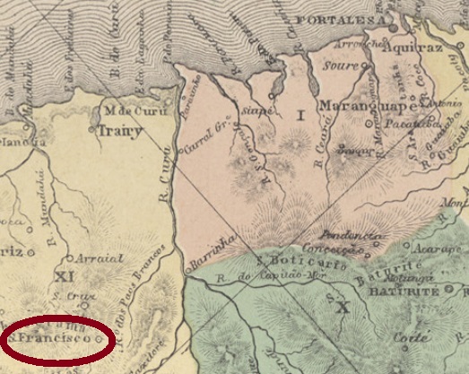
The villa of Sao Francisco da Uruburetama was founded in July 1859 by merging several small villages and was located about 125 km west of the provincial capital Fortaleza. The name was shortened to S. Francisco in 1893, and the town was degraded to a district of Arraial (now Uruburetama) for two years from 1931. After regaining independence, the place name changed to Itapagé in 1943, which has been written Itapajé since 1989.
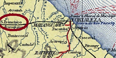
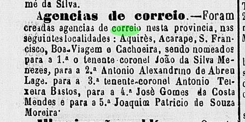
The local post office was established in 1872, as can be read on the regional press:
Cearense, 4 July 1872
Unfortunately, no postmark from the imperial era could be surely assigned to this place so far.
Carta da Republica dos Estados Unidos do Brazil, 1892
Buchtext-Aktualisierung vom 7. Februar 2021
Andere Namen: São Francisco da Uruburetama, Itapagé (1943)
Die Villa von São Francisco da Uruburetama wurde im Juli 1859 durch Zusammenlegung mehrerer kleinen Ortschaften gegründet und lag ca. 125 km westlich der Provinzhauptstadt Fortaleza entfernt. Der Name wurde 1893 offiziell zu São Francisco gekürzt, und der Ort war ab 1931 zwei Jahre lang als Distrikt von Arraial (heute Uruburetama) degradiert. Nach Wiedererlangen der Eigenständigkeit wechselte der Ortsnamen 1943 zu Itapagé, das seit 1989 Itapajé geschrieben wird.
Das örtliche Postamt entstand 1872, wie aus der Regionalpresse hervorgeht:
Cearense, 4. Juli 1872
Leider konnte bisher kein Poststempel aus der Kaiserzeit diesem Ort mit Sicherheit zugeordnet werden.
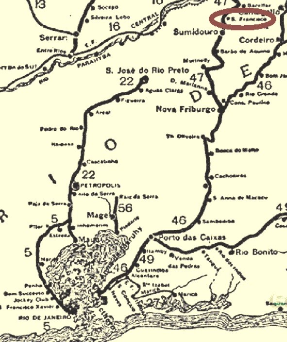
The station of S. Francisco was inaugurated in October 1885 by the E.F. Leopoldina Railway Company and was located in the so-called Sumidouro junction (Ramal) in the municipality of Carmo, more than 150 km north of Rio de Janeiro. This station was soon called Barra de Sao Francisco because it was located at the mouth (Barra) of the river of the same name into the Paquequer River. Today, Barra de Sao Francisco is a district of Carmo, and rail operations ceased in October 1967.
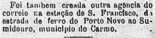
The station post office was established in January 1886, as announced in the Rio press:
Gazeta de Noticias, January 13, 1886
6 copies of the only station cancel of the Empire were found, all from 1886. SRJ-0928a (Coll. Karlheinz Wittig) consists of a double circle with the inscriptions EST DE S. FRAN.o above and RAMAL DE SUMIDOURO below, with date at the centre.
Almanak Laemmert, 1892
Der Bahnhof São Francisco wurde im Oktober 1885 durch die E.F. Leopoldina Bahngesellschaft eingeweiht und lag in der so genannten Sumidouro-Abzweigung (Ramal) in der Gemeinde Carmo, über 150 km nördlich von Rio de Janeiro entfernt. Dieser Bahnhof wurde bald Barra de São Francisco genannt, da er an der Mündung (Barra) des gleichnamigen Flusses in den Paquequer-Fluss lag. Heute ist Barra de São Francisco ein Ortsteil von Carmo, und der Bahnbetrieb wurde im Oktober 1967 eingestellt.
Das Bahnhofspostamt wurde im Januar 1886 ins Leben gerufen, wie in der Rio-Presse bekannt gegeben:
Gazeta de Noticias, 13. Januar 1886
Vom einzigen Bahnhofsstempel im Kaiserreich wurden 6 Exemplare gefunden, allesamt aus 1886. SRJ-0928a (Samml. Karlheinz Wittig) besteht aus einem Doppelkreis mit den Inschriften EST DE S. FRAN.o oben und RAMAL DE SUMIDOURO unten, dazu Datum in der Mitte.
Other names: Villa de Sao Francisco da Barra do Sergipe do Conde, S. Francisco do Conde (1943)
The series of villages dedicated to St. Francis in the Brazilian Empire begins in the province of Bahia, where a villa was founded in November 1697, bearing the sonorous name of S. Francisco da Barra do Sergipe do Conde. It was located in the north of All Saints’ Bay, less than 70 km northwest of the provincial capital Salvador. In June 1931, the place name was simplified to S. Francisco, to which an additional do Conde came in December 1943.
As can be read in the 1885 Imperial Mail Register (Tabella das Agencias do Correio do Imperio), there is a post office on place since 1872. This is confirmed by the provincial president’s report of March 1873:
Relatorio do Presidente da Provincia, pg 37
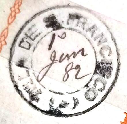
The only imperial postmark so far is the French type SBA-0815a (Coll. Fuad Ferreira Fo.). As it was not shown in Carimbologia S1, it is presented here:
SBA-0815a (FF), 1882-1901
Please note: in Carimbologia S1 (pg 161) there is a post office in the Bahian railway station of São Francisco (SBA-0817). This station was inaugurated in February 1880 by the E.F. from Bahia to São Francisco. Further research revealed that the cancel registered there comes rather from the train station of S. Francisco Xavier, in the Municipio Neutro (SMN-2185). The agency of the Bahia station, therefore, possibly never existed.
Villiers de l’Ile Adam: Carta (…) da Provincia da Bahia, 1848
Buchtext-Aktualisierung vom 19. Oktober 2021
Andere Namen: Villa de São Francisco da Barra do Sergipe do Conde, S. Francisco do Conde (1943)
Die Reihe der dem Hl. Franz gewidmeten Ortschaften im Kaiserreich Brasilien beginnt in der Provinz Bahia, wo bereits im November 1697 eine Villa gegründet wurde, die den sonoren Namen São Francisco da Barra do Sergipe do Conde trug. Sie lag im Norden der Allerheiligenbucht, knapp 70 km nordwestlich der Provinzhauptstadt Salvador entfernt. Im Juni 1931 wurde der Ortsnamen zu São Francisco vereinfacht, der aber seit Dezember 1943 wieder den Zusatz do Conde trägt.
Der bisher einzige kaiserliche Poststempel ist der Französischer Typ SBA-0815a (Samml. Fuad Ferreira Fo.). Da er nicht in Carimbologia S1 abgebildet wurde, wird er hier präsentiert:
SBA-0815a (FF), 1882-1901
Bitte beachten: In Carimbologia S1 (S. 161) wird ein Postamt im Bahia-Bahnhof von São Francisco (SBA-0817) vorgestellt. Letzter wurde im Februar 1880 von der E.F. von Bahia nach São Francisco eingeweiht. Weitere Untersuchungen ergaben, dass der dort abgebildete Stempel eher vom Bahnhof S. Francisco Xavier im Municipio Neutro (SMN-2185) stammen soll. Die Agentur im Bahia-Bahnhofs gab es daher möglicherweise nie.
Villiers de l’Ile Adam: Carta (…) da Provincia do Rio de Janeiro, 1850
Printed version update from February 4, 2021
Another name : São Fidelis de Sigmaringa
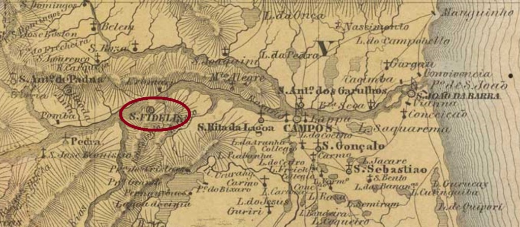
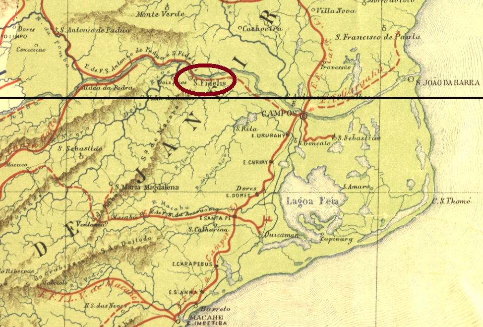
Saint Fidelis of Sigmaringen (1578-1622), philosopher, jurist, religious priest and martyr, also had his admirers in colonial Brazil. The parish of Sao Fidelis de Sigmaringa was founded in 1812 on the south bank of the Parahyba do Sul river near Campos, 300 km northeast of Rio de Janeiro. In April 1840 it was elevated to a freguesia and exactly 10 years later to a villa. Since December 1870, it has been a town.
As Nova Monteiro in Administrações e Agencias Postaes do Brasil Imperio (Brasil Filatelico/RJ, 1934-5; Reprint SPP 1994-1999) reports, there is a post office there since November 1833. So you can find many imperial cancels here, starting with SRJ-0925a, which was used from the beginning until at least 1868 and was already presented by Paulo Ayres (Catalogo de Carimbos Brasil-Império, S. Paulo, 1937, 1942) under No. 1456:
SRJ-0925a (P. Ayres 1456, RHM P-RJ-42)
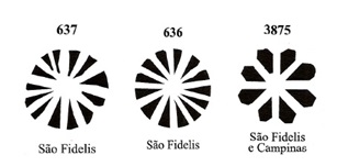
There followed SRJ-0925b (Coll. José A. Junges): a simple double circle with inscription S. FIDELIS above and the date at the centre, period of use ca. 1878-1886. SRJ-0925c (Coll. Dieter Kerkhoff) is similar to his predecessor, but has an additional diamond-shaped ornament at the bottom of the circles, which consists of four small diamonds. Copies were found for the period 1884-1889. At SRJ-0925d (image from the internet) the lower ornament consists of three ellipses in series, the middle one standing, the others lying. 1889 to 1892. Finally, SRJ-0925e (Coll. Karlheinz Wittig) may already be Republican, since its dates at the centre go from 1894 until 1899: here too we have a double circle with S. FIDELIS above, the ornament below is now an X.
Four mute cancels could be assigned to this place, three of which were identified by A. Dingler and K. Lopes (Mute Cancellations of the Brazil Empire / Carimbos Mudos do Brasil Império, Brazil Philatelic Association, Rio de Janeiro, 2000):
Dingles/Lopes (op. cit.)
The fourth mute cancel was found on an envelope from 1868 (image from the internet):
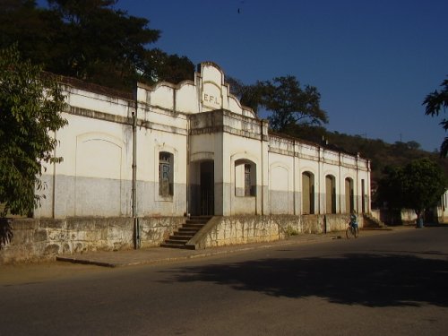
In January 1880, a railway station of the E.F. Santo Antonio de Padua Railway Company was inaugurated in Sao Fidelis. In 1884, the line ownership went to E.F. Macahe a Campos, in 1887 to E. F. Leopoldina, and from 1975 to the end of the company’s operation in 1996, to the Rede Ferroviária Federal S.A. Now the building seems unused (estacoesferroviarias.com.br):
In 2008 (Photo: Ricardo Q. Mattos, apud estacoesferroviarias.com.br)
As Paulo Novaes (agenciaspostais.com.br) reports, there was also a train station post office from 1880 on, which had a short service life. Two station cancels were found: SRJ-0926a (Coll. José A. Junges) is the oldest of them, the only copy, in turquoise, was used in 1883: a double circle with inscriptions EST. CENTRAL above and E.F.S.F. below, with date at the centre. It was followed by SRJ-0926b (agenciaspostais.com.br). Here the inscriptions are more detailed: EST CENTRAL above and E.F. DE S. FIDELIS below. Used 1884-1890.
Estrada de Ferro Central do Brasil, 1890
Buchtext-Aktualisierung vom 4. Februar 2021
Anderer Name : São Fidelis de Sigmaringa
Auch der Heilige Fidelis von Sigmaringen (1578-1622), Philosoph, Jurist, Ordenspriester und Märtyrer, hatte seine Verehrer im kolonialen Brasilien. So wurde 1812 die Pfarrei São Fidelis de Sigmaringa am Südufer des Flusses Parahyba do Sul bei Campos, 300 km nordöstlich von Rio de Janeiro errichtet. Im April 1840 wurde sie zur Freguesia und exakt 10 Jahre später zur Villa erhoben. Seit Dezember 1870 ist São Fidelis eine Stadt.
Wie Nova Monteiro in Administrações e Agencias Postaes do Brasil Imperio (Brasil Filatelico/RJ, 1934-5; Reprint SPP 1994-1999) berichtet, gibt es dort ein Postamt seit November 1833. Also kann man hier viele imperiale Stempel vorfinden, beginnend mit SRJ-0925a, der vom Betriebsbeginn bis mindestens 1868 verwendet und bereits durch Paulo Ayres (Catálogo de Carimbos Brasil-Império, S. Paulo, 1937, 1942) unter Nr. 1456 vorgestellt wurde:
SRJ-0925a (P. Ayres 1456, RHM P-RJ-42)
Es folgte SRJ-0925b (Samml. José A. Junges): ein schlichter Doppelkreis mit Inschrift S. FIDELIS oben und dem Datum in der Mitte, Verwendungsperiode ca. 1878-1886. SRJ-0925c (Samml. Dieter Kerkhoff) ist ähnlich wie sein Vorgänger, hat aber ein zusätzliches Ornament in Rautenform unten zwischen den Kreisen, das aus vier kleinen Rauten besteht. Exemplare für den Zeitraum 1884-1889 gefunden. Bei SRJ-0925d (Abb. aus dem Internet) besteht das untere Ornament aus drei Ellipsen in Reihe, die Mittlere davon stehend, die anderen liegend. Von 1889 bis 1892. Schließlich könnte SRJ-0925e (Samml. Karlheinz Wittig) bereits republikanisch sein, da seine bisherigen Daten in der Mitte zwischen 1894 und 1899 liegen: auch hier haben wir einen Doppelkreis mit S. FIDELIS oben, das Ornament unten ist nun ein X.
Vier stumme Stempel konnten diesem Ort zugeordnet werden, drei davon haben A. Dingler und K. Lopes (Mute Cancellations of the Brazil Empire / Carimbos Mudos do Brasil Império, Brazil Philatelic Association, Rio de Janeiro, 2000) identifiziert:
Dingles/Lopes, op. cit.)
Der vierte Stempel wurde auf einem Umschlag aus 1868 vorgefunden (Abb. aus dem Internet):
Im Januar 1880 wurde in São Fidelis ein Bahnhof der E.F. Santo Antonio de Padua Eisenbahngesellschaft eingeweiht. 1884 ging der Linienbesitz zur E.F. Macahe a Campos, 1887 zur E. F. Leopoldina, und von 1975 bis Betriebsende 1996, zur Rede Ferroviária Federal S.A. Nun steht das Gebäude anscheinend ohne Benutzung da (estacoesferroviarias.com.br):
In 2008 (Foto: Ricardo Q. Mattos, apud estacoesferroviarias.com.br)
Wie Paulo Novaes (agenciaspostais.com.br) berichtet, gab es auch ab 1880 ein Bahnhofspostamt, das allerdings von kurzer Betriebsdauer war. Zwei Bahnhofsstempel sind da: SRJ-0926a (Samml. José A. Junges) ist davon der Älteste, das einzige Exemplar wurde 1883 in türkis verwendet: ein Doppelkreis mit Inschriften EST. CENTRAL oben und E.F.S.F. unten, dazu Datum in der Mitte. Ihm folgte SRJ-0926b (agenciaspostais.com.br). Hier sind die Inschriften etwas ausführlicher: EST CENTRAL oben und E.F. DE S. FIDELIS unten. Benutzt 1884-1890.
This was a small settlement in the municipality of Cavalcante, more than 500 km northeast of the provincial capital Goyaz (today Goiás Velho). The village became an arraial in November 1831 and experienced a fast development through the discovery of gold deposits. These were soon exhausted, however, and S. Felix was then abandoned by the gold diggers. Today, the place has disappeared from the map, and remains only through its beautiful waterfalls in the memory of its visitors.
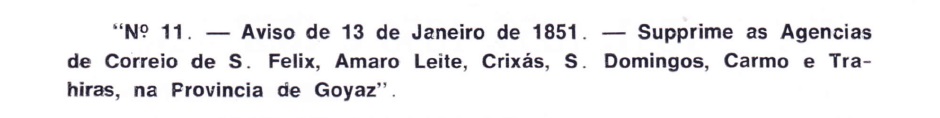
According to Nova Monteiro (Administrações e Agencias Postaes do Brasil Imperio, in Brasil Filatelico/RJ, 1934-5; Reprint SPP 1994-1999) there was a post office there as early as March 1829, but it was closed again in January 1851, as Aureo G. Santos reports in Agências de Correio Criadas e Suprimidas 1851, 1855, 1856 e 1857 (Brasil Filatélico 181, 1977):
Aureo G. Santos (op. cit.)
No imperial post cancel from this S. Felix could be found so far.
Villiers del’Ile Adam: Carta (…) da Provincia de Goyaz, 1849
São Felix war eine kleine Siedlung im Município von Cavalcante, die über 500 km nordöstlich der Provinzhauptstadt Goyaz (heute Goiás Velho) entfernt lag. Die Ortschaft wurde im November 1831 ein Arraial und erfuhr einen raschen Aufschwung durch die Entdeckung von Goldvorkommen. Dieses wurde aber bald ausgeschöpft, und São Felix wurde anschließend von den Goldgräbern verlassen. Heute ist ist der Ort von der Karte verschwunden, und bleibt nur durch seine schönen Wasserfälle in der Erinnerung seiner Besucher.
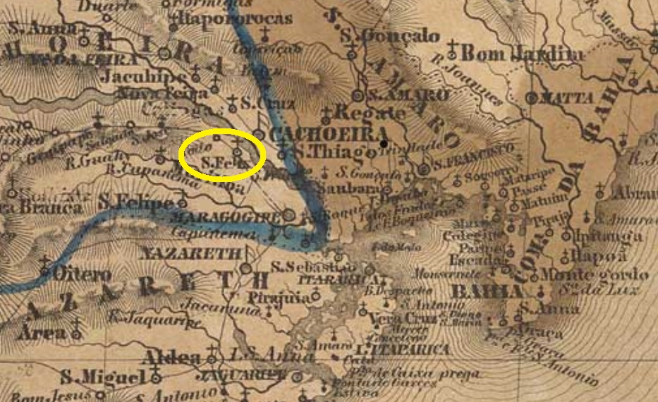
From October 1857 on, São Felix was a district in the municipality of Cachoeira, located on the west bank of the Paraguassu River, about 120 km northwest of the provincial capital Salvador da Bahia. In December 1889 the village was elevated to a villa and is a town since October 1890.
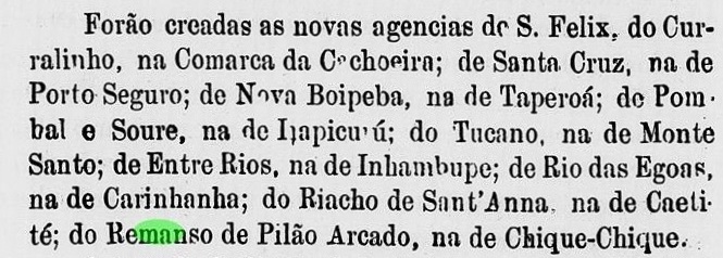
The local post office was probably built between the end of 1875 and the beginning of 1876, as its creation is listed in the provincial government’s report of May 1876:
Relatorio do Presidente da Provincia, May 1876
Two early cancellations were found, both with republican dates. SBA-0810a (image from the internet) has a double circle with the inscription S. FELIX above. The dates at the centre are from 1890 to 1895. SBA-0810b (Coll. Fuad Ferreira Fo.) is a handwritten cancel used on an issue from 1893. One reads S. Feli(x) and a date 16-9-(…).
Villiers de l’Ile Adam: Carta (…) da Provincia da Bahia, 1848
São Felix war ab Oktober 1857 ein Distrikt im Município von Cachoeira, der am Westufer des Flusses Paraguassu lag, ca. 120 km nordwestlich der Provinzhauptstadt Salvador da Bahia. Im Dezember 1889 wurde der Ort zur Villa erhoben, und ist eine Stadt seit Oktober 1890.
Das örtliche Postamt wurde wohl zwischen Ende 1875 und Anfang 1876 errichtet, da seine Entstehung im Bericht der Provinzregierung vom Mai 1876 angepriesen wird:
Relatorio do Presidente da Provincia, Mai 1876
Zwei frühe Entwertungen waren zu finden, beide mit Daten aus der Republik. SBA-0810a (Abb. aus dem Internet) hat einen Doppelkreis mit der Inschrift S. FELIX oben. Die Daten in der Mitte gehen von 1890 bis 1895. SBA-0810b (Samml. Fuad Ferreira Fo.) ist eine handgeschriebene Entwertung, die auf einer Ausgabe aus 1893 verwendet wurde. Man liest S. Feli(x), dazu ein Datum 16-9-(…).
In the province of Bahia, São Felippe (also written Philippe or Felipe) was formerly a freguesia in the municipality of Maragogipe, which is located almost 90 km west of the provincial capital Salvador and was elevated to villa in May 1880. Since March 1938, the locality has been a town.
As can be read in the Imperial Mail Register (Tabella das Agencias do Correio do Imperio) of 1885, there is a post office there since 1881, which is also confirmed by the annual report of the provincial president for 1882:
Relatório do Presidente da Provincia, January 1882
An early postmark was found: SBA-0610a (Coll. José A. Junges) consists of a double circle with inscription S. FELIPPE above. The only copy has a date of 1893 at the centre.
Villiers de l’Ile Adam: Carta (…) da Provincia da Bahia, 1848
São Felippe (auch Philippe oder Felipe geschrieben) in der Provinz Bahia war früher eine Freguesia im Município von Maragogipe, die knapp 90 km Luftlinie westlich der Provinzhauptstadt Salvador liegt und im Mai 1880 zur Villa erhoben wurde. Seit März 1938 ist die Ortschaft eine Stadt.
Ein früher Poststempel wurde gefunden: SBA-0610a (Samml. José A. Junges) besteht aus einem Doppelkreis mit Inschrift S. FELIPPE oben. Das einzige Exemplar trägt ein Datum aus 1893 in der Mitte.
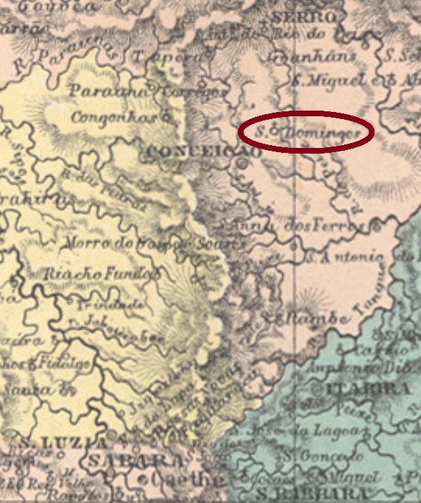
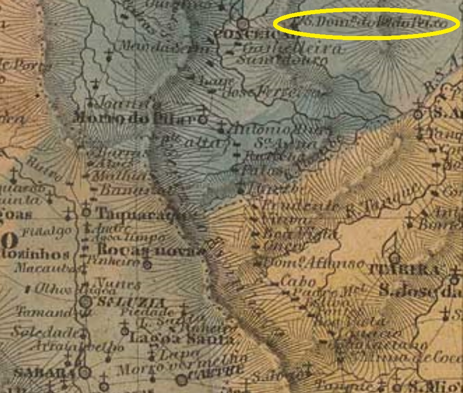
The last Dominic – for now – of the province of Minas Gerais is São Domingos do Rio do Peixe (= From the Fish River, at a time when you could fish a lot). It was a district do Serro (now Conceição do Mato Dentro) and was located less than 300 km north of the provincial capital Ouro Preto. In December 1938, it ascended to the municipality of Dom Joaquim. The name is a tribute to the former archbishop of Diamantina, Joaquim Silvério de Souza.
Paula Sobrinho (História Postal de Minas Gerais, Belo Horizonte, 1977) writes that the local post office was created in August 1883. The earliest postmark we have seen so far is SMG-2250a (Coll. José A. Junges): a double circle with the inscription S. DOMINGOS DE RIO DO PEIXE above and an ornament in cross form below. Dates at the centre from 1890 until 1899.
Villiers de l’Ile Adam: Carta (…) da Provincia de Minas Geraes, 1849
Anderer Name: Dom Joaquim (1938)
Der letzte Dominikus – fürs Erste – der Provinz Minas Gerais ist São Domingos de Rio do Peixe (= vom Fischfluss, aus einer Zeit also, in der man viel angeln konnte). Die Ortschaft war ab Oktober 1870 ein Distrikt von Conceição do Serro (heute Conceição do Mato Dentro) und lag knapp 300 km nördlich der Provinzhauptstadt Ouro Preto entfernt. Im Dezember 1938 stieg sie zum Município von Dom Joaquim auf. Der Name huldigt den früheren Erzbischof von Diamantina, Joaquim Silvério de Souza.
In seiner História Postal de Minas Gerais (Belo Horizonte, 1977), schreibt Paula Sobrinho, dass das örtliche Postamt im August 1883 entstanden ist. Der früheste Poststempel, den wir bisher gesichtet haben, ist SMG-2250a (Samml. José A. Junges): ein Doppelkreis mit der Inschrift S. DOMINGOS DE RIO DO PEIXE oben und einem Ornament in Kreuzform unten. Daten in der Mitte von 1890 bis 1899.
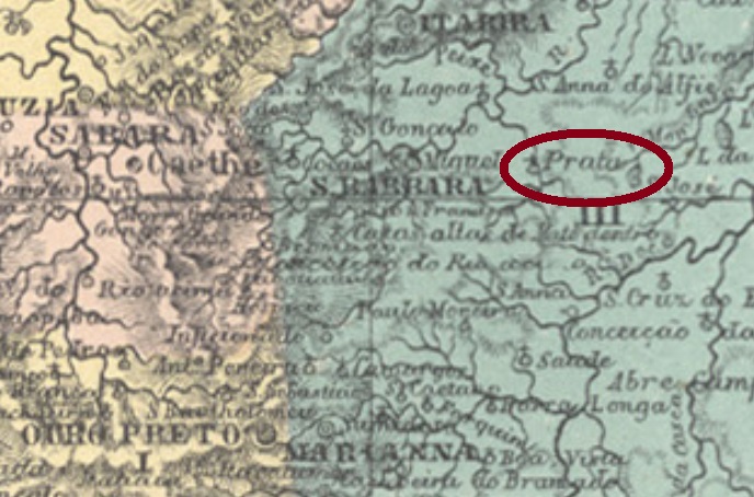
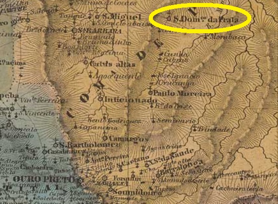
This other Saint Dominic of the province of Minas Gerais is another locality dedicated to Dominic de Guzmán (1170-1221), founder of the Order of the Dominicans. It is situated almost 150 km northeast of the provincial capital Ouro Preto, on the western bank of the Rio da Prata (not the famous river that separates Uruguay from Argentina, but rather its 215 km Brazilian cousin, a tributary of the Tejuco River). In July 1843 the freguesia was established, which would soon be elevated to a village. Since March 1890 is a city and municipality.
In his História Postal de Minas Gerais (Belo Horizonte, 1997) writes Paula Sobrinho that the local post office was created in October 1875. The only known imperial cancel so far is SMG-2245a (internet image): a double circle with the inscription S. DOMINGOS DO PRATA above and an ornament below, formed by four arrowheads in cross. The dates at the centre were found for the period from 1884 to 1893.
Villiers de l’Ile Adam: Carta (…) da Provincia de Minas Geraes, 1849
Dieser andere Skt. Dominikus der Provinz Minas Gerais ist ein weiterer Ort, der Dominikus (1170-1221), dem Gründer des Dominikanerordens, gewidmet ist. Er liegt am westlichen Ufer des Rio da Prata (nicht der berühmte Fluss, der Uruguay von Argentinien trennt, aber sein kleiner, 215 km langer Namensvetter aus Minas Gerais, ein Nebenfluss des Tejuco), fast 150 km nordöstlich der Provinzhauptstadt Ouro Preto. Im Juli 1843 wurde die Freguesia gegründet, die bald zum Dorf erhoben werden sollte. Seit März 1890 ist São Domingos do Prata eine Stadt und Município.
In seiner História Postal de Minas Gerais (Belo Horizonte, 1997) schreibt Paula Sobrinho, dass das örtliche Postamt im Oktober 1875 errichtet wurde. Der bisher einzige bekannte kaiserliche Stempel ist SMG-2245a (Internetbild): ein Doppelkreis mit der Inschrift S. DOMINGOS DO PRATA oben und einem Ornament unten, gebildet von vier Pfeilspitzen in Kreuz. Die Daten in der Mitte wurden für die Zeit von 1884 bis 1893 gefunden.
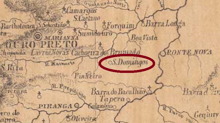
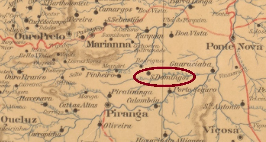
Other names: São Domingos, Vasconcelos, Diogo de Vasconcelos (1928)
From September 1881 on, this village was a freguesia in the municipality of Marianna, about 60 km east of the provincial capital Ouro Preto. In September 1923, the name changed to Vasconcelos, when the locality was elevated to a district. Five years later, it was called Diogo de Vasconcelos, which has been an independent municipality since December 1962. The name is a tribute to Diogo Luís de A.P. de Vasconcelos (1843-1927), a historian, politician, journalist, and lawyer from the region.
As Paula Sobrinho reports in his Historia Postal de Minas Gerais (Belo Horizonte, 1997), there has been a post office there since February 1882. The only found cancel to date, SMG-2235a (Coll. José A. Junges), consists of a double circle with the inscriptions S. DOMINGOS above and (MUNo. MARIANNA) below. The only copy has a date from 1890 at the centre.
Mappa do Estado de Minas Geraes, 1910
Andere Namen: São Domingos, Vasconcelos, Diogo de Vasconcelos (1928)
Diese Ortschaft war ab September 1881 eine Freguesia im Município von Marianna, die rund 60 km östlich der Provinzhauptstadt Ouro Preto entfernt lag. Im September 1923 wechselte der Name zu Vasconcelos, als der Ort zu einem Distrikt erhoben wurde. Fünf Jahre später hieß er Diogo de Vasconcelos, der seit Dezember 1962 als eigenständiger Município ist. Der Name soll an Diogo Luís de A.P. de Vasconcelos (1843-1927) erinnern, einem Historiker, Politiker, Journalist und Jurist aus der Gegend.
Wie Paula Sobrinho in seiner Historia Postal de Minas Gerais (Belo Horizonte, 1997) berichtet, gibt es dort ein Postamt seit Februar 1882. Der bisher einzige überlieferte Poststempel, SMG-2235a (Samml. José A. Junges), besteht aus einem Doppelkreis mit den Inschriften S. DOMINGOS oben und (MUNo. MARIANNA) unten. Das einzige Exemplar hat ein Datum aus 1890 in der Mitte.