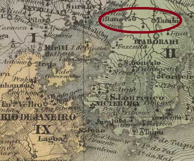
Villiers de l’Ile Adam: Carta (…) da Provincia do Rio de Janeiro, 1850
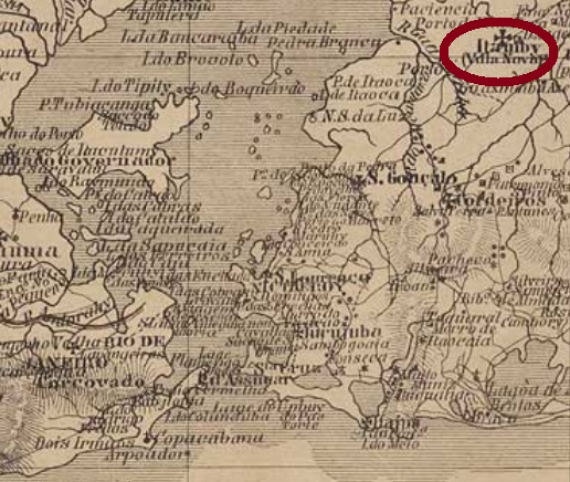
Other names: São José del Rei, Villa Nova de Itamby, Itambi
This post office was discovered through the Carimbologia project: a locality which disappeared 180 years ago, i.e. still in the pre-philatelic period, and belonged to a municipality that no longer exists, either. It began in November 1759, with the foundation of the freguesia of Nossa Senhora do Desterro de Itamby, which took part of the now extint municipality of Santo Antonio de Sá, located under 50 km northeast of the imperial capital. In 1772 it became a villa called São José del Rei, that after a short decadence went in 1833 as the freguesia of São Bernabé to the municipality of São João de Itaborahy. This status remained until 1840, when São Bernabé merged with other localities into the Villa Nova de Itamby, which is now Itambi, in the outskirts of the town of Itaboraí. We don’t know the causes of such a turbulent history, whether they are political, economic or ecological nature, or even a combination among them.
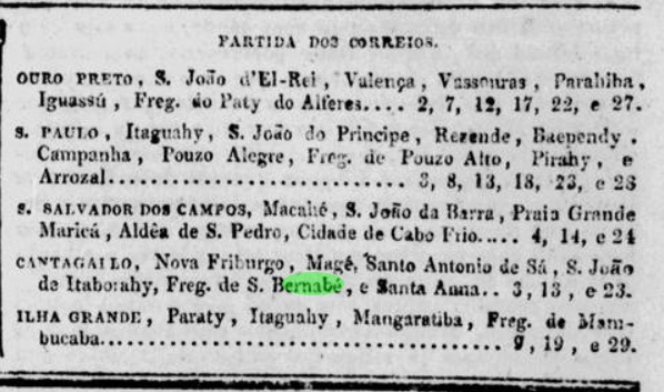
No creation date for the local post office has been found until now, but it must have taken place before March 1834, when the post line to Cantagallo was reported to pass through São Bernabé:
Jornal do Commercio, March 14, 1834
The agency remained open presumably until ca. 1842 – for after that it wasn’t mentioned anymore – and would only reopen in 1862 as the Itamby post office. No postal cancel from São Bernabé has been found either.
Bellegard/Niemeyer: Carta (…) do Rio de Janeiro, 1867
Andere Namen: São José del Rei, Villa Nova de Itamby, Itambi
Dieses Postamt wurde durch die Carimbologia-Recherchen entdeckt: eine vor 180 Jahren verschwundene Ortschaft – also noch in der Vorphila-Ära – die einer Gemeinde angehörte, die inzwischen auch nicht mehr existiert. Die Geschichte begann im November 1759 mit der Gründung der Freguesia von Nossa Senhora do Desterro de Itamby im inzwischen ausgelöschten Município von Santo Antonio de Sá, knapp 50 km nordöstlich der kaiserlichen Hauptstadt Rio de Janeiro gelegen. 1772 wurde daraus die Villa von São José del Rei, die nach einem raschen Verfall im Jahr 1833 zur Freguesia von São Bernabé im Município von São João de Itaborahy abstieg. Dieser Status hielt bis 1840, als São Bernabé mit anderen Ortschaften zur Villa Nova de Itamby (heute Itambi) zusammen gelegt wurde, heute ein Vorort der Stadt Itaboraí. Wir wissen nicht die Gründe für eine solch turbulente Geschichte, ob sie politischer, wirtschaftlicher oder ökologischer Natur sind, oder auch eine Mischung davon.
Kein Gründungsdatum fürs örtliche Postamt wurde bisher gefunden. Da aber ab März 1834 eine Postlinie von Rio bis Cantagallo über São Bernabé in der Rio Presse erwähnt wird, muss die Agentur kurz davor errichtet worden sein:
Jornal do Commercio, 14. März 1834
Das Postamt blieb in Betrieb vermutlich bis Ende 1842, danach wird es in dieser Linie nicht mehr erwähnt; erst 1862 würde es wieder eröffnen, nun in der Villa von Itamby. Ebenso wenig wurde bisher kein Poststempel von São Bernabé gefunden.
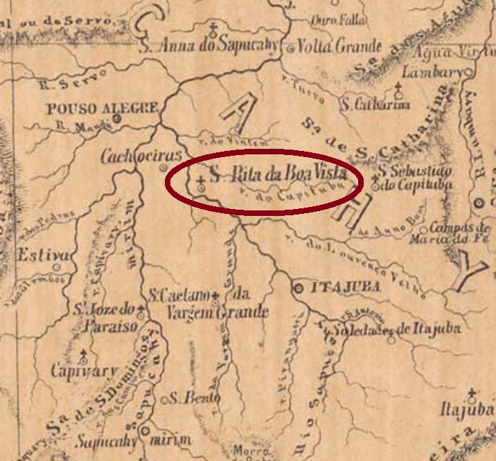
Other names: Santa Rita, Santa Rita da Boa Vista, Santa Rita do Vintém
As like Santo Antonio da Boa Vista (SAL-0245), I have simply forgotten to put this locality in the Carimbologia S1 book. So let’s introduce it with all available data and images.
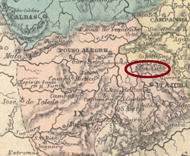
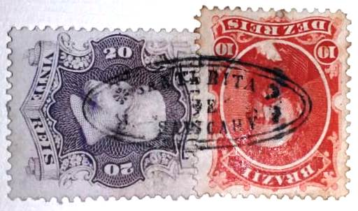
This was the former freguesia of Santa Rita of the municipality of São Sebastião do Capituba, which switched to Pouso Alegre and, in November 1880 already with the actual name, to São Gonçalo do Sapucahy. As the name suggests, it was located on the east bank of the Sapucahy (now written Sapucaí) River, round 450 km southwest of the province capital Ouro Preto. In September 1888 it emancipated as a villa and was declared a town in May 1892. The population in 1880 was 4.145 inhabitants, for 2020 43.753 souls were estimated (IBGE).
Both Nova Monteiro (Administrações e Agencias Postaes do Brasil Imperio, in Brasil Filatelico/RJ, 1934-5; Reprint SPP 1994-1999) and Paula Sobrinho (História Postal de Minas Gerais, Belo Horizonte, 1997) agree in asserting that the local post office was created in September 1866. Four early cancels were found, the third one might be already republican:
SMG-2920a (Coll. Fuad Ferreira Fo.), used 1866ffSMG-2920b (image from the internet), used 1886-1890SMG-2920c (Coll. Karlheinz Wittig), used 1897
The fourth cancel SMG-2920d was recently discovered by Felipe Piccinini on an envelope from 1880, which also featured a very interesting mute cancel:
SMG-2920d (FP) 18801880 (FP)
With special thanks to Fuad Ferreira Fo, who made this complement possible.
Provincia de Minas Geraes, 1873
Textaktualisierung am 29. August 2024
Andere Namen: Santa Rita, Santa Rita da Boa Vista, Santa Rita do Vintém
Wie bei Santo Antonio da Boa Vista (SAL-0245) habe ich einfach vergessen, diese Ortschaft ins Buch Carimbologia S1 einzutragen. Also wird sie hier in vollem Umfang vorgestellt, auch mit allen Stempelbildern.
Der Ort war früher die Freguesia von Santa Rita im Município von São Sebastião do Capituba, der später nach Pouso Alegre und – im November 1880 bereits unter dem aktuellen Namen – zu São Gonçalo do Sapucahy. Wie man erahnen kann, liegt die Ortschaft am Ostufer des Flusses Sapucahy (heute Sapucaí geschrieben), rund 450 km südwestlich der Provinzhauptstadt Ouro Preto entfernt. Im September 1888 wurde sie zur Villa, und im Mai 1892 zur Stadt ernannt. Aus 4.145 Einwohnern 1880 wurden im Jahre 2020 geschätzte 43.753 Seelen (IBGE).
Sowohl Nova Monteiro (Administrações e Agencias Postaes do Brasil Imperio, in Brasil Filatelico/RJ, 1934-5; Reprint SPP 1994-1999) als auch Paula Sobrinho (História Postal de Minas Gerais, Belo Horizonte, 1997) sind sich darüber einig, dass das örtliche Postamt im September 1866 entstand. Vier frühe Stempel wurden für den 19. Jahrhundert gefunden, wobei der dritte davon wohl republikanisch ist:
SMG-2920a (Samml. Fuad Ferreira Fo.), verwendet 1866ffSMG-2920b (Abb. aus dem Internet), verwendet 1886-1890SMG-2920c (Samml. Karlheinz Wittig), verwendet 1897
Der vierte Poststempel SMG-2920d wurde kürzlich von Felipe Piccinini auf einem Briefumschlag aus dem Jahr 1880 entdeckt, der auch einen sehr interessanten stummen Stempel enthielt:
SMG-2920d (FP) 18801880 (FP)
Mit besonderem Dank an Fuad Ferreira Fo., der diesen Nachtrag veranlasst hat.
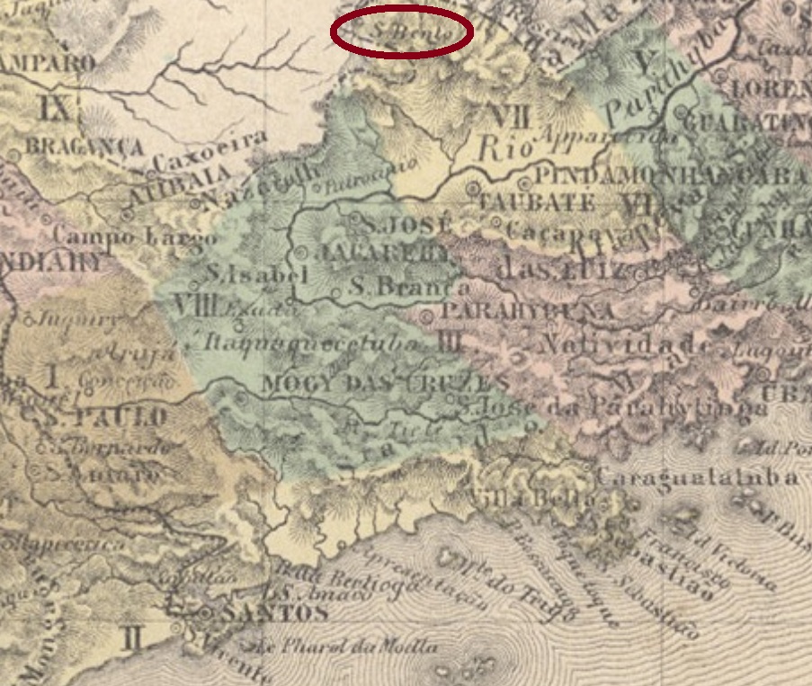
Other names: São Bento de Sapucahy, S. Bento do Sapucaí
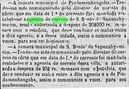
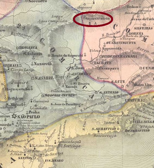
This locality was a former freguesia of Pindamonhangaba, situated on the east bank of the Sapucaí-Mirim River, near the Minas Gerais border, some 200 km northeast of the province capital São Paulo. Sapucaí-Mirim means small shouting river in the tupi-guarani language. The place was made a villa in May 1858 and is a town since March 1876.
Apparently, this office was closed shortly after, for a reopening in June 1864 was announced in the regional press:
Correio Paulistano, June 15, 1864
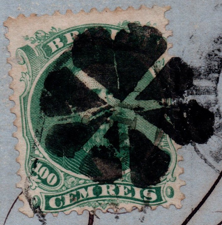
We can present three imperial local cancels, else than a mute one. The oldest one is SSP-1670a (Coll. José A. Junges), a single circle with inscription S.BTO DE SAPUC. MIRIM above and a five-leg star below. The centre is free for writing the date by hand, but both known examples (used at least until 1866) have no date inside. SSP-1670b (Coll. José A. Junges) presents now a double circle with inscription S. B. DE SAPUCAHYMERIM and dates at the centre between 1877 and 1880. SSP-1670c (image from the internet) is a French-type double circle with inscription S. B. DE SAPUCAHY above and the star between parentheses below. Dates available 1885-1890.
The mute cancellation was found on an envelope to Rio, posted with a 100 réis D. Pedro issue of 1866 and accompanying SSP-1670b:
(Coll. José A. Junges), 1866ffVilliers de l’Ile Adam: Carta (…) da Provincia de São Paulo, 1847
Andere Namen: São Bento de Sapucahy, S. Bento do Sapucaí
Diese Ortschaft war eine ehemalige Freguesia von Pindamonhangaba, die am Ostufer des Flusses Sapucaí-Mirim nah an der Grenze zu Minas Gerais lag, etwa 200 km nordöstlich der Provinzhauptstadt São Paulo entfernt. Sapucaí-Mirim bedeutet kleiner schreiender Fluss in der Tupi-guarani Indianersprache. Der Ort stieg zur Villa im Mai 1858 und zur Stadt im März 1876 auf.
Zwei Daten furs örtliche Postamt waren zu finden. Nova Monteiro (Administrações e Agencias Postaes do Brasil Imperio, in Brasil Filatelico/RJ, 1934-5; Reprint SPP 1994-1999) und der Postbericht für 1859 schreiben den Dezember 1857. Dieses Datum wurde durch Aureo G. Santos in Agências de Correio Criadas e Suprimidas 1851, 1855, 1856 e 1857 (Brasil Filatélico 181, Rio de Janeiro) bestätigt:
Aureo G. Santos, op.cit.
Scheinbar aber wurde die Agentur kurz danach geschlossen, da eine Wiedereröffnung im Juni 1864 in der Regionalpresse bekannt gegeben wurde:
Correio Paulistano, 15. Juni 1864
Wir können drei Ortsstempeln vorstellen, dazu eine „stumme“ Entwertung. Der älteste Stempel ist SSP-1670a (Samml. José A. Junges): ein Kreis mit Inschrift S.BTO DE SAPUC. MIRIM oben und einem fünfzackigen Stern unten. Die Mitte ist für ein handgeschriebenes Datum frei, aber beide Exemplare (benutzt mindestens bis 1866) tragen kein Datum. SSP-1670b (Samml. José A. Junges) zeigt nun einen Doppelkries mit Inschrift S. B. DE SAPUCAHYMERIM und Daten in der Mitte zwischen 1877 und 1880. SSP-1670c (Abb. aus dem Internet) ist ein Französischer-Typus: Doppelkreis mit Inschrift S. B. DE SAPUCAHY oben und ein kleiner Stern in Klammern unten. Vorhandene Daten 1885-1890.
Die stumme Abstempelung war auf einem Umschlag nach Rio zu finden, frankiert mit einer 100 Réis D. Pedro-Ausgabe von 1866 und begleitet vom SSP-1670b:
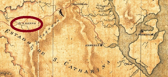
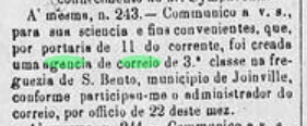
This São Bento in the Santa Catarina province was from April 1876 on a freguesia in the municipality of Joinville, situated round 250 km north of the capital Desterro (today Florianópolis). In May 1883 it ascended to a villa that has changed the name twice since then: in December 1943 to Serra Alta, and five years later to the actual São Bento do Sul.
The local post office was created in April 1881, as reported by the regional press:
O Despertador, April 30, 1881
There are two imperial post cancels for this locality, both are double circles. SSC-0205a (Coll. José A. Junges) has the inscription S. BENTO above and a diamond ornament below, formed by four small squares and dated 1881-1887 at the center. SSC-0205b (Coll. José A. Junges) occurs also in blue, here the inscriptions are S.BENTO above and (S.CATHARINA) below. Dates from ca. 1884 until 1916 at the centre.
Mappa do Estado do Paraná, 1892
Andere Namen: Serra Alta, São Bento do Sul (1948)
Dieser São Bento in der Provinz Santa Catarina war ab April 1876 eine Freguesia im Município von Joinville, die rund 250 km nördlich der Hauptstadt Desterro (heute Florianópolis) entfernt lag. Im Mai 1883 stieg sie zu einer Villa auf, die danach den Namen zweimal wechselte: im Dezember 1943 zu Serra Alta und fünf Jahre später zum heutigen São Bento do Sul.
Das örtliche Postamt wurde im April 1881 ins Leben gerufen, wie die Regionalpresse berichtet:
O Despertador, 30. April 1881
Es gibt zwei Poststempel aus dem Kaiserreich für die Ortschaft, beide sind Doppelkreisen. SSC-0205a (Samml. José A. Junges) hat die Inschrift S. BENTO oben und ein Rautenornament unten, das aus vier kleinen Quadraten besteht und in der Mitte datiert ist (1881-1887). SSC-0205b (Samml. José A. Junges) erscheint auch in blau; hier lauten die Inschriften S.BENTO oben und (S.CATHARINA) unten. Daten von ca. 1884 bis 1916 in der Mitte.
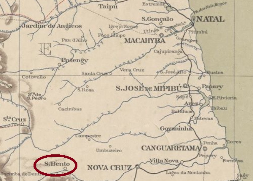
São Bento was since March 1835 a district of the municipality of Goianinha, situated round 100 km southwest of the province capital Natal. In March 1852 it ascended to a villa, which became a town under the actual name of Nova Cruz in December 1919.
The local post office was created in December 1874, as stated by the province president’s report for May 1875:
Relatório do Presidente da Provincia, May 1875
No imperial cancel could be safely identified for this locality until now.
Serviço Geológico e Mineralógico, 1910
Anderer name: Nova Cruz (1919)
São Bento war ab März 1835 ein Distrikt im Município von Goianinha, der rund 100 km südwestlich der Provinzhauptstadt Natal entfernt lag. Im März 1852 stieg er zur Villa auf, die im Dezember 1919 zur Stadt Nova Cruz erklärt wurde.
Das örtliche Postamt entstand im Dezember 1874, wie im Bericht des Provinzpräsidenten für Mai 1875 geschrieben:
Relatório do Presidente da Província, Mai 1875
Für diese Ortschaft konnte bisher kein Poststempel der Kaiserzeit zweifelsfrei identifiziert werden.
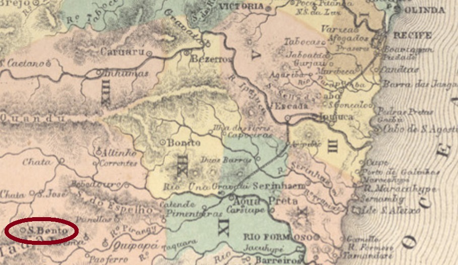
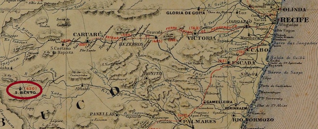
This São Bento in the Pernambuco province was since May 1853 a district in the municipality of Garanhuns, situated round 200 km west of the capital Recife. In April 1860 it was elevated to a villa and in June 1900, to a town, which since December 1943 is called São Bento do Una.
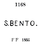
Two imperial post cancels appeared. SPE-0525a was used from the beginning, having been already presented by Paulo Ayres in his Catálogo de Carimbos Brasil-Império, (S. Paulo, 1937, 1942) under # 1168:
SPE-0525a, P. Ayres 1168
It was followed by the French-type SPE-0525b: a double circle with the inscription S. BENTO above and the small star between parentheses below. Dates from 1887-1888 were applied by hand at the centre.
Carta Corographica de Pernambuco, 1880
Anderer Name: São Bento do Una (1943)
Dieser São Bento in der Provinz Pernambuco war ab Mai 1853 ein Distrikt im Município von Garanhuns, der rund 200 km westlich der Hauptstadt Recife lag. Im April 1860 stieg er zur Villa und im Juni 1900 zur Stadt auf. Der Município heißt seit Dezember 1943 São Bento do Una.
Laut Nova Monteiro (Administrações e Agencias Postaes do Brasil Imperio, in Brasil Filatelico/RJ, 1934-5; Reprint SPP 1994-1999) gibt es dort ein Postamt seit August 1864, wie die Lokalpresse berichtet:
Diario de Pernambuco, 20. August 1864
Zwei Poststempel der Kaiserzeit sind vorhanden. SPE-0525a war vom Anfang an im Gebrauch und wurde bereits durch Paulo Ayres in seinem Catálogo de Carimbos Brasil-Império (S. Paulo, 1937, 1942) unter Nr. 1168 vorgestellt:
SPE-0525a, P. Ayres 1168
Ihm folgte der Französisch-Typus SPE-0525b: ein Doppelkreis mit Inschrift S. BENTO oben und dem Sternchen zwischen Klammern unten. Die Daten (1887-1888) wurden per Hand in die Mitte eingetragen.
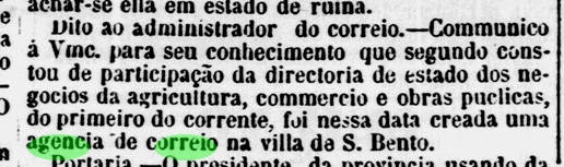
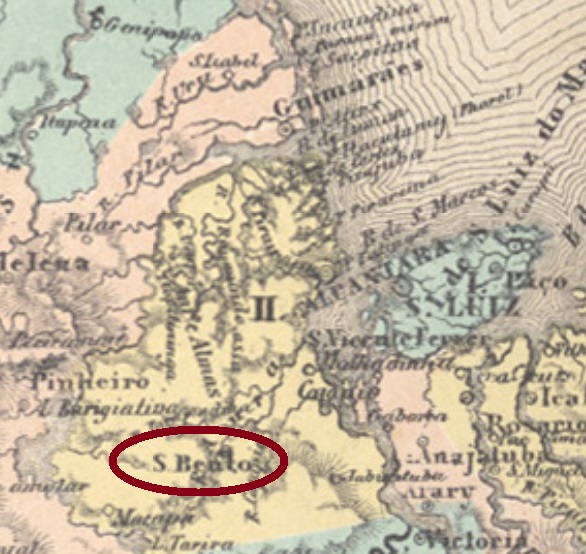
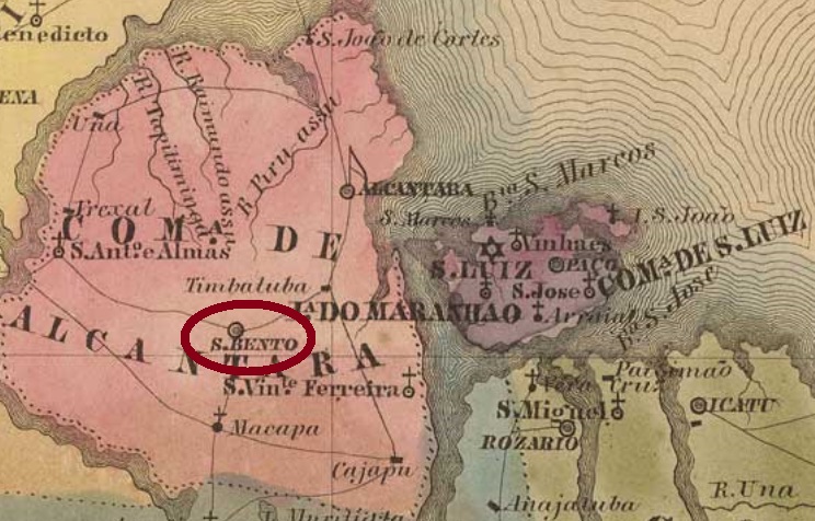
São Bento was since November 1805 a freguesia of Alcântara, situated over 120 km west of the later province capital São Luís. In April 1833, the locality emancipated as a villa, which became a town in March 1905.
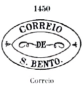
Only one imperial cancel from this locality could be safely identified. SMA-0220a was used around 1866, having been already presented by Paulo Ayres in Catálogo de Carimbos Brasil-Império (S. Paulo, 1937, 1942) under #1450:
SMA-0220a, P.A. 1450Villers de l’Ile Adam: Carta (…) da Provincia do Maranhäo, 1850
Anderer Name: São Bento dos Perizes
São Bento war ab November 1805 eine Freguesia von Alcântara, die über 120 km westlich der späteren Provinzhauptstadt São Luís entfernt lag. Im April 1833 erhielt die Gemeinde die politische Eigenständigkeit und wurde eine Stadt im März 1905.
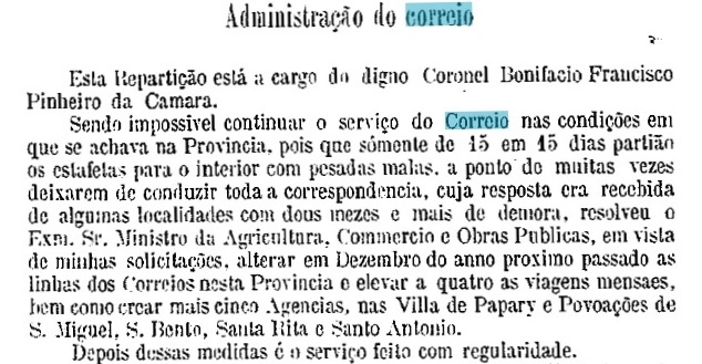
Fürs örtliche Postamt wurden nicht weniger als drei verschiedene Entstehungsjahre gefunden. Nova Monteiro (Administrações e Agencias Postaes do Brasil Imperio, in Brasil Filatelico/RJ, 1934-5; Reprint SPP 1994-1999) schreibt dafür den Juni 1856; das Jahr wird sowohl durch den Postbericht für 1859 als auch durch Áureo G. Santos (Agências de Correio Criadas e Suprimidas 1851, 1855, 1856 e 1857, in Brasil Filatélico 181, Rio de Janeiro) bestätigt:
Aureo G. Santos (op. cit.)
Auf der anderer Seite listet das Verzeichnis der kaiserlichen Postämter (Tabella das Agencias do Correio do Imperio) von 1885 diese Agentur ab 1865 auf, während der Postbericht für 1887 ein Datum vom Januar 1875 präsentiert. Wahrscheinlich war das Postamt zwischendurch geschlossen.
Ein einziger kaiserlicher Stempel dieser Ortschaft konnte bisher ermittelt werden. SMA-0220a wurde um 1866 verwendet und bereits durch Paulo Ayres in seinem Catálogo de Carimbos Brasil-Império (S. Paulo, 1937, 1942) unter Nr. 1450 vorgestellt:
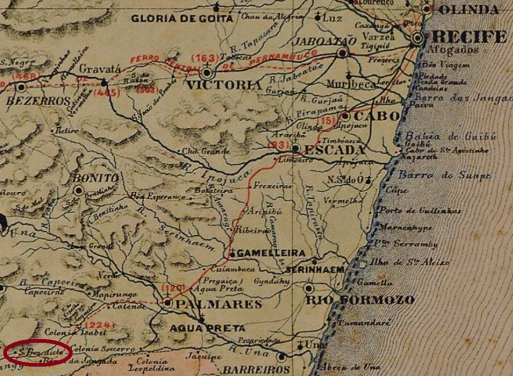
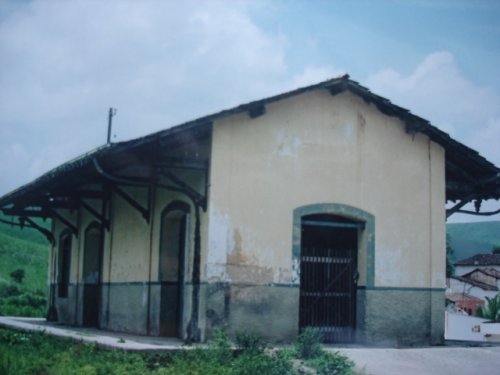
São Benedicto was a train station of the Sul de Pernambuco Railway, built in September 1884 in the municipality of Quipapá, over 170 km southwest of the province capital Recife. A settlement startet shortly after, and in October 1899 a district was established. The train line passed in 1901 to the Great Western Railway. In December 1943 the district was renamed Iraci, seven years later the railway belonged to the Rede Ferroviária do Nordeste. In December 1963 the political emancipation took place with the creation of the municipality of São Benedito do Sul. The railway’s last period (1975-1996) was under the Rede Ferroviária Federal S.A., before operation ended.
The station post office was created in October 1889, according to the Postal Report:
Boletim Postal, November 1889
No postal cancel from the empire has appeared until now.
In 2007 (Photo: Claudio Vitoriano, apud estacoesferroviarias.com.br)
Andere Namen: Iraci, São Benedito do Sul (1963)
São Benedicto war ein Bahnhof der Sul de Pernambuco Eisenbahngesellschaft, der im September 1884 im Município von Quipapá gebaut wurde, über 170 km südwestlich der Provinzhauptstadt Recife. Bald darauf wuchs eine Siedlung um den Bahnhof herum, und im Oktober 1899 wurde ein Distrikt gegründet. Die Eisenbahnlinie ging 1901 zur Great Western Railway. Im Dezember 1943 wurde der Distrikt Iraci umbenannt, und sieben Jahre danach ging die Bahnstrecke zur Rede Ferroviária do Nordeste über. Im Dezember 1963 fand die politische Emanzipation als Municipio von São Benedito do Sul statt. Am Ende des Bahnbetriebs gehörte die Bahnlinie der Rede Ferroviária Federal S.A. (1975-1996).
Laut Postbericht entstand das Bahnhofspostamt im Oktober 1889:
Boletim Postal, November 1889
Kein Poststempel der Kaiserzeit war bisher zu finden.
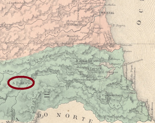
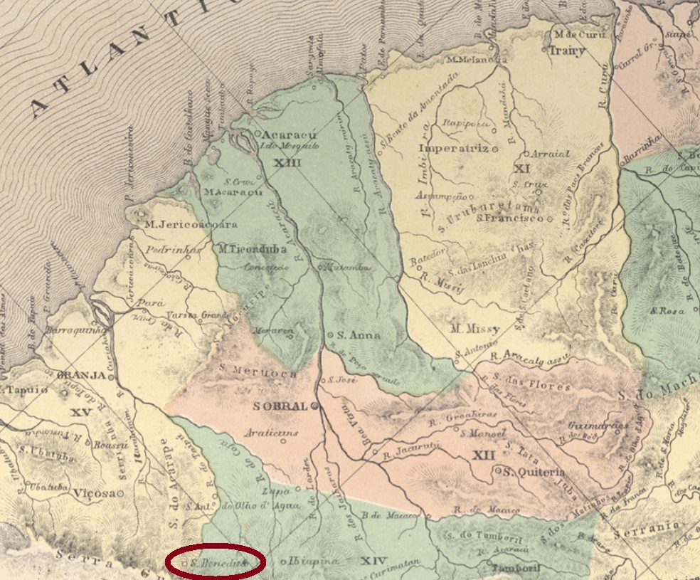
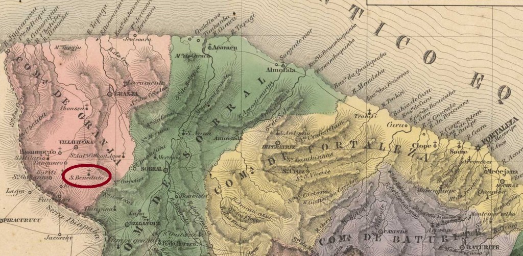
São Benedicto was since January 1851 a district of the municipality of Viçosa, situated over 300 km west of the provincial capital Fortaleza. In November 1872 it ascended to a villa, and in August 1921 to a town named São Benedicto de Ibiapina. Since May 1931 it is the municipality of São Benedicto.
According to the Imperial Mail Register (Tabella das Agencias do Correio do Imperio) of 1885, the local post office was created in 1877. One imperial cancel was found. SCE-0275a (Coll. José A. Junges) has a double circle with the inscription S. BENEDICTO above and a diamond ornament below. Dates at the centre from the beginning until 1895.
Villiers de l’Ile Adam: Carta (…) da Provincia do Ceará, 1849
Anderer name: São Benedicto de Ibiapina (1921)
São Benedicto war ab Januar 1851 ein Distrikt im Município von Viçosa, der über 300 km westlich der Provinzhauptstadt Fortaleza lag. Im November 1872 stieg der Ort zur Villa auf, im August 1921 wurde daraus die Stadt São Benedicto de Ibiapina. Seit Mai 1931 ist es der Município von São Benedicto.
Laut Verzeichnis der kaiserlichen Postämter (Tabella das Agencias do Correio do Imperio) von 1885 gibt es dort ein Postamt seit 1877. Ein Stempel der Kaiserzeit ist vorhanden. SCE-0275a (Samml. José A. Junges) hat einen Doppelkreis mit der Inschrift S. BENEDICTO oben und einem Ornament in Rautenform unten. Die Daten in der Mitte gehen vom Betriebsbeginn bis 1895.
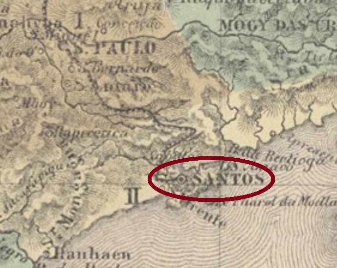
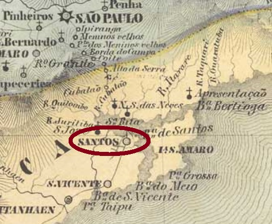
Santos is one of the oldest localities in Brazil, having been declared a Villa as early as November 1st, 1546. It was thus named after the All Saints‘ Day, located ca. 80 km southeast of the later capital São Paulo, and became a town in January 1839.
Two dates for the creation of the post office were reported. Nova Monteiro (Administrações e Agencias Postaes do Brasil Imperio, in Brasil Filatelico/RJ, 1934-5; Reprint SPP 1994-1999) writes exactly December 21, 1844, while the Imperial Mail Register (Tabella das Agencias do Correio do Império) of 1885 lists the agency from 1845 on. But as early as September 24, 1817, a royal document (Carta Régia) signed by D. João VI ordered a regular mail service between the provinces of S. Paulo and S. Pedro, beginning in the capital São Paulo and passing through Santos, Rio Grande and Porto Alegre until the arrival in Rio Pardo. This mail line would hardly work without establishing post offices on the main itinerary stops. The Carta Régia in original Portuguese can be read here:
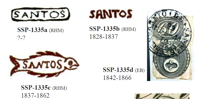
Another evidence for an earlier creation date of the post office is the existence of at least four different pre-philatelic cancels:
SSP-1335a, b, c, d (Carimbologia S1)
SSP-1335e (Coll. Fuad Ferreira Fo.) was used 1867-1882, ocurring in black and violet. It is a French type, with the inscription SANTOS above, the small star between parentheses below, and dates the centre. SSP-1335f was already presented by Paulo Ayres (Catálogo de Carimbos Brasil-Império, S. Paulo, 1937, 1942), existing in black and blue:
SSP-1335f (P.Ayres)
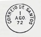
SSP-1335g (Coll. Mario Orsi Jr.) has a double circle with the inscription SANTOS above and dated at the centre (1880). Then there follow three cancels with SANTOS above, ornaments at both sides between the circles and a T below, from the eighties:
SSP-1335h (Coll. Mario Orsi Jr.) shows 5.== T. below, the ornaments are diamonds formed by four diamonds (1880-1885). SSP-1335i (image from the internet) has 1.== T. below, the ornaments are squares formed by four small squares, occurring also in blue (1883-1889). SSP-1335j (Coll. Mario Orsi Jr.) presents 2 – T below, the ornaments are small squares (1886-1890, year sometimes missing).
The next cancels are for registered mail. SSP-1335k (Coll. José A. Junges) is a double circle wih inscriptions SANTOS above and REGISTRADO below, separated by small squares at both sides (1885). SSP-1335l (Coll. Mario Orsi Jr.) is almost identical as before, but now the squares are missing (1889-1890).
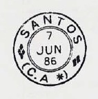
The last circle cancels are for the rail mail (Correio ambulante). They all have double circles with SANTOS above, (C.A.) below and dates at the centre. SSP-1335m (1880-1888, sometimes the year is missing) was already presented by Paulo Ayres:
SSP-1335m (P. Ayres, op. cit.)
SSP-1335n (Coll. Karlheinz Wittig) has six-leg star ornaments (1885-1886). SSP-1335o (Coll. Karlheinz Wittig) has eight-petal flowers (1885-1893). SSP-1335p (Coll. Karlheinz Wittig) shows four-leaf clovers (1886-1892).
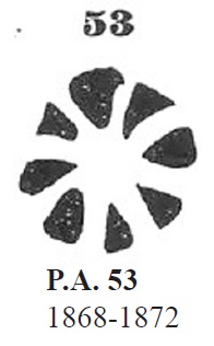
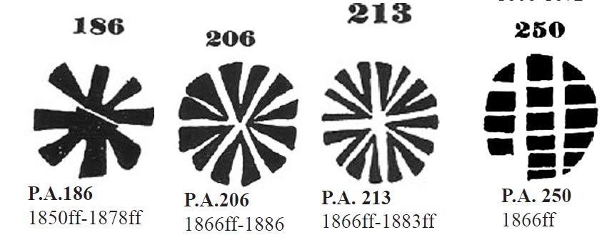
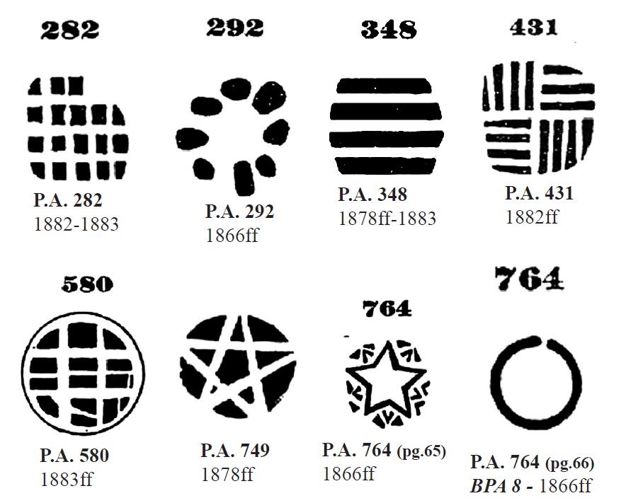
There are also thirteen mute cancels presented by P. Ayres for Santos, two of which are erroneously listed with the same number 764:
Carimbologia S1, (P. Ayres op.cit.)
Moreover, James A. Dingler and Klerman W. Lopes (Mute Cancellations of the Brazil Empire / Carimbos Mudos do Brasil Império, Brazil Philatelic Association, Rio de Janeiro, 2000) presented other fourteen mute cancels from Santos under the BPA #283, 368, 519, 552, 1216, 1474, 1599, 2323, 2731, 2777, 3140, 3616, 3848 and 4294. Finally, Mario Orsi Jr has found four unlisted mute cancels used in 1869, 1880, 1883 and c. 1885. One further mute cancel was found by José A. Junges (used in 1877), who also presents us a manuscript cancellation of 1883:
Coll. José A. JungesViliers de l’Ile Adam: Carta (…) da Provincia de S. Paulo, 1847
Santos ist eine der ältesten Ortschaften Brasiliens und wurde bereits am 1. November 1546 zur Villa erklärt. Das Datum der Allerheiligen bestimmte also den Namen des Orts, der ca. 80 km südöstlich der späteren Provinzhauptstadt São Paulo entfernt lag und im Januar 1839 zur Stadt aufstieg.
Zwei Daten für die Entstehung des Postamts sind überliefert. Nova Monteiro (Administrações e Agencias Postaes do Brasil Imperio, in Brasil Filatelico/RJ, 1934-5; Reprint SPP 1994-1999) schreibt dafür exakt den 21 Dezember 1844, während das Verzeichnis der kaiserlichen Postämter (Tabella das Agencias do Correio do Império) von 1885 die Agentur ab 1845 auflistet. Gleichwohl wurde bereits am 24. September 1817 ein königliches Dokument (Carta Régia) durch D. João VI unterschrieben, das die Einführung einer regulären Postlinie zwischen den Provinzen von S. Paulo und S. Pedro anordnete, die in der Provinzhauptstadt São Paulo startete, durch Santos, Rio Grande und Porto Alegre passierte und deren Ende Rio Pardo war. Diese Postlinie wäre kaum oder überhaupt nicht durchführbar ohne die Gründung von Postämtern an den wichtigsten Haltestellen. Die Carta Régia kann man im portugiesischen Original hier lesen:
Ein weiterer Hinweis für den früheren Postbetrieb in Santos ist das Vorhandensein von mindestens vier Stempeln, die in der Vorphila-Zeit (also vor 1843) im Gebrauch waren:
SSP-1335a, b, c, d (Carimbologia S1)
SSP-1335e (Samml. Fuad Ferreira Fo.), verwendet 1867-1882, kommt in schwarz und violett vor. Es ist ein Französischer-Typ mit Inschrift SANTOS oben, dem Sternchen zwischen Klammern unten und Datum in der Mitte. SSP-1335f wurde bereits durch Paulo Ayres (Catálogo de Carimbos Brasil-Império, S. Paulo, 1937, 1942) vorgestellt und kommt in schwarz und blau vor:
SSP-1335f (P.Ayres)
SSP-1335g (Samml. Mario Orsi Jr.) hat einen Doppelkreis mit der Inschrift SANTOS oben und Datum in der Mitte (1880). Es folgen drei Stempel mit SANTOS oben, Ornamente beidseitig zwischen den Kreisen und einem T unten, die in den 80er-Jahren verwendet wurden:
SSP-1335h (Samml. Mario Orsi Jr.) zeigt 5.== T. unten, die Ornamente sind Rauten, die jeweils durch vier kleine Rauten gebildet werden (1880-1885). SSP-1335i (Abb. aus dem Internet) hat einen 1.== T. unten, die Ornamente sind Quadrate, die aus vier kleinen Quadraten bestehen. Kommt in schwarz und blau vor (1883-1889). SSP-1335j (Samml. Mario Orsi Jr.) zeigt 2 – T unten, die Ornamente sind kleine Quadrate (1886-1890, manchmal fehlt die Jahresangabe).
Die nächsten Stempel sind für Einschreibpost. SSP-1335k (Samml. José A. Junges) ist ein Doppelkreis mit der Inschrift SANTOS oben, dazu REGISTRADO unten, an beiden Seiten durch kleine Quadrate getrennt (1885). SSP-1335l (Samml. Mario Orsi Jr.) ist fast identisch wie vor, nun fehlen hier die Quadrate (1889-1890).
Die letzten Rundstempel sind für die ambulante Bahnpost bestimmt (Correio ambulante). Sie alle haben Doppelkreise mit SANTOS oben, (C.A.) unten, Ornamente beidseitig und Daten in der Mitte. SSP-1335m (1880-1888, Jahresangabe nicht immer zu lesen) wurde bereits von Paulo Ayres gezeigt:
SSP-1335m (P. Ayres, op. cit.)
In SSP-1335n (Samml. Karlheinz Wittig) sind die Ornamente sechszackige Sterne (1885-1886). SSP-1335o (Samml. Karlheinz Wittig) hat Blümchen mit je acht Blättchen (1885-1893). SSP-1335p (Samml. Karlheinz Wittig) zeigt vierblättrige Kleeblätter (1886-1892).
Aus Santos sind weitere dreizehn „stummen“ Stempel, die bereits durch Paulo Ayres vorgestellt wurden. Dabei haben die zwei letzten die gleiche Nummer 764:
P. Ayres (op.cit.) – aus Carimbologia S1
Darüber hinaus zeigten James A. Dingler und Klerman W. Lopes (Mute Cancellations of the Brazil Empire / Carimbos Mudos do Brasil Império, Brazil Philatelic Association, Rio de Janeiro, 2000) vierzehn andere “stummen” Stempel aus Santos unter den BPA-Nr. 283, 368, 519, 552, 1216, 1474, 1599, 2323, 2731, 2777, 3140, 3616, 3848 und 4294. Dann fand Mario Orsi Jr. vier weitere, bisher unbekannte “stumme” Stempel, die in den Jahren 1869, 1880, 1883 und ca. 1885 verwendet wurden. Schließlich fand José A. Junges einen letzten stummen Stempel (1877 verwendet), dazu eine handgeschriebene Entwertung aus 1883: