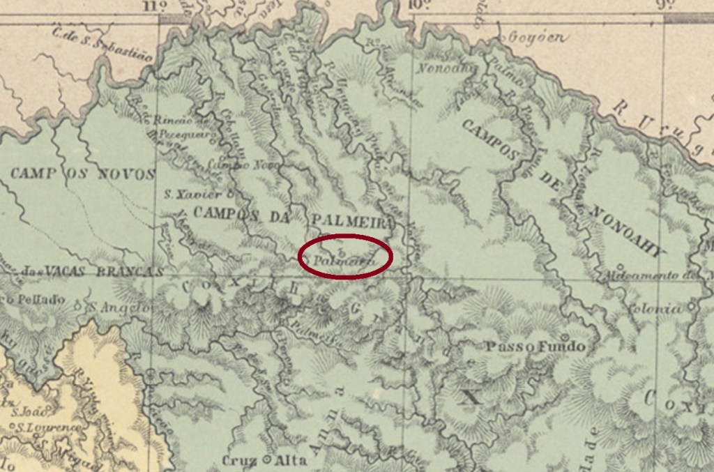
Other names: Vilinha de Palmeira, Palmeira, Palmeira das Missões (1944)
A former district of the municipality of Cruz Alta, Santo Antonio da Palmeira was situated almost 400 km northwest of the province capital Porto Alegre. It emancipated politically in May 1874 under the name of Palmeira, which changed to the actual Palmeira das Missões in December 1944.
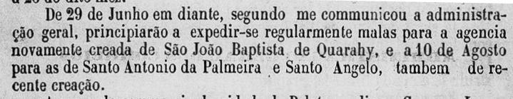
According to the Province President Report for 1879, the local post office startet operations in August 1878:
Relatório do Presidente da Provincia/RS, 1879
No postal cancel of the Empire has been found with this toponym until now.
Provincia de São Pedro, 1877
Andere Namen: Vilinha de Palmeira, Palmeira, Palmeira das Missões (1944)
Santo Antonio da Palmeira war ein ehemaliger Distrikt von Cruz Alta, der fast 400 km nordwestlich der Provinzhauptstadt Porto Alegre entfernt lag. Im Mai 1874 erhielt er seine politische Selbständigkeit als Município unter den Ortsnamen Palmeira. Dieser wechselte im Dezember 1944 zum aktuellen Palmeira das Missões.
Laut dem Bericht des Provinzpräsidenten für 1879 startete der Betrieb des örtlichen Postamts im August 1878:
Relatório do Presidente da Provincia/RS, 1879
Kein Poststempel des Kaiserreichs unter diesem Ortsnamen konnte bisher gefunden werden.
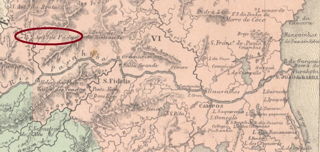
The freguesia of Santo Antonio de Padua was founded in June 1843 on the Pomba River, municipality of São Fidellis, round 250 km northeast of the imperial capital Rio de Janeiro. In January 1882 it ascended to a villa in own municipality and became a town in December 1889.
It was followed by SRJ-0900b (image from the internet): a double circle with the inscription S. A. DE PADUA above and a ( I ) below. The dates at the centre were found for the period 1884-1885. SRJ-0900c (Coll. José A. Junges) was in circulation between 1885 and 1887. Here the inscription between the circles is S. ANTONIO DE PADÚA (with a curious wrong accent upon the U), and the ornament below is now a diamond formed by four small diamonds. Dates at the centre. SRJ-0900d (Coll. Paulo Novaes) is the last imperial cancel, with central dates between 1889 and 1894. The inscription between circles is now corrected to S. ANTONIO DE PADUA, but here the inferior ornament is an X.
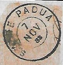
After the release of Carimbologia S1 another cancel was found: SRJ-0900e (Coll. Paulo Novaes) has a double circle with the inscription S. A. DE PADUA above. The dates inside vary from 1883 to 1885.
SRJ-0900e (agenciaspostais.com.br)
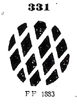
The local mute cancellation has accompanied quite often SRJ-0900a between ca. 1866 and at least 1883, its image was also depicted by Paulo Ayres (op. cit.) under # 331:
P.Ayres #331Villiers de l’Ile Adam: Carta (…) da Provincia do Rio de Janeiro, 1850
Aktualisierung der Buchausgabe, am 15. Mai 2021
Die Freguesia von Santo Antonio de Padua wurde im Juni 1843 am Fluss Pomba im Município von São Fidellis gegründet und lag rund 250 km nordöstlich der kaiserlichen Hauptstadt Rio de Janeiro. Im Januar 1882 stieg sie zur eigenständigen Villa auf und wurde zur Stadt im Dezember 1889 erklärt.
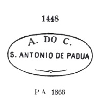
Laut Nova Monteiro (Administrações e Agencias Postaes do Brasil Imperio, in Brasil Filatelico/RJ, 1934-5; Reprint SPP 1994-1999) entstand das örtliche Postamt im Februar 1855. Fünf Ortsstempel und ein “Stummer” wurden bisher gefunden. Der früheste davon, SRJ-0900a, wurde wohl von Anfang an bis zumindest 1866 verwendet und war bereits durch Paulo Ayres in seinem Catálogo de Carimbos Brasil-Império (S. Paulo, 1937, 1942) unter Nr. 1448 bekannt gemacht:
SRJ-0900a (P. Ayres #1448)
Ihm folgte SRJ-0900b (Abb. aus dem Internet): ein Doppelkreis mit der Inschrift S. A. DE PADUA oben und einem ( I ) unten. Die Daten in der Mitte wurden für den Zeitraum 1884-1885 gefunden. SRJ-0900c (Samml. José A. Junges) wurde zwischen 1885 und 1887 verwendet. Hier lautet die Inschrift zwischen den Kreisen S. ANTONIO DE PADÚA (mit einem merkwürdigen falschen Akzent auf dem U), und das untere Ornament ist nun eine Raute, die aus vier kleinen Rauten besteht. Daten in der Mitte. SRJ-0900d (Samml. Paulo Novaes) ist der letzte Stempel der Kaiserzeit, die inneren Daten gehen von 1889 bis 1894. Die Inschrift zwischen den Kreisen ist nun zu S. ANTONIO DE PADUA korrigiert, und das untere Ornament ist ein X.
Nach dem Erscheinen von Carimbologia S1 ein weiterer Ortsstempel wurde gefunden: SRJ-0900e (Samml. Paulo Novaes) hat einen Doppelkreis mit der Inschrift S. A. DE PADUA oben. Die Daten im Inneren gehen von 1883 bis 1885.
SRJ-0900e (agenciaspostais.com.br)
Die stumme Abstempelung begleitete oft SRJ-0900a zwischen ca. 1866 und zumindest 1883; deren Abbildung lieferte ebenfalls Paulo Ayres (op. cit.), unter Nr. 331:
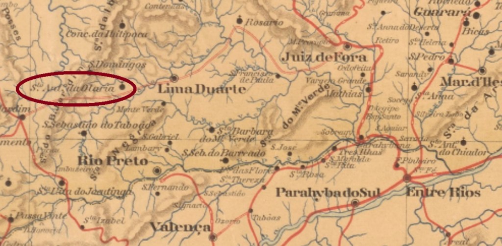
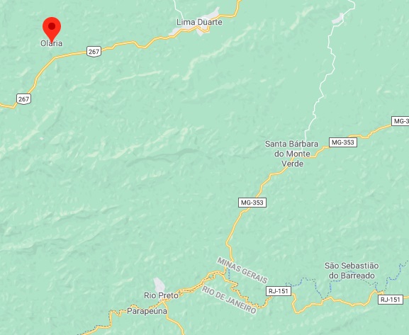
Santo Antonio da Olaria (= St. Anthony of the Brickworks) was since July 1872 a district in the municipality of Rio Preto, situated ca. 230 km south of the provincial capital Ouro Preto. In September 1923 it switched to the newly created municipality of Lima Duarte and had the name simplified to Olaria in December 1938. Since December 1962 has Olaria an own municipality.
According to Paula Sobrinho (História Postal de Minas Gerais, Belo Horizonte, 1997), the local post office was created in March 1885. One imperial cancel was found. SMG-2975a (Coll. Karlheinz Wittig) occurs in black and blue and has a double circle with the inscriptions S. ANTo. DA OLARIA above and (MINAS) below. Dates at the centre between 1889 and 1895.
GoogleMaps
Anderer Name: Olaria (1938)
Santo Antonio da Olaria (= Hl. Antonius der Ziegelei) war ab Juli 1872 ein Distrikt im Município von Rio Preto, der ca. 230 km südlich der Provinzhauptstadt Ouro Preto lag. Im September 1923 wechselte der Ort zum frisch gegründeten Município von Lima Duarte und bekam im Dezember 1938 den Namen zu Olaria vereinfacht. Seit Dezember 1962 ist Olaria eine eigenständige Gemeinde.
Wie Paula Sobrinho (História Postal de Minas Gerais, Belo Horizonte, 1997) schreibt, gibt es dort ein Postamt seit März 1885. Ein Stempel des Kaiserreichs wurde gefunden. SMG-2975a (Samml. Karlheinz Wittig) kommt in schwarz und blau vor und hat einen Doppelkreis mit den Inschriften S. ANTo. DA OLARIA oben sowie (MINAS) unten. Die Daten in der Mitte entstammen dem Zeitraum 1889-1895.
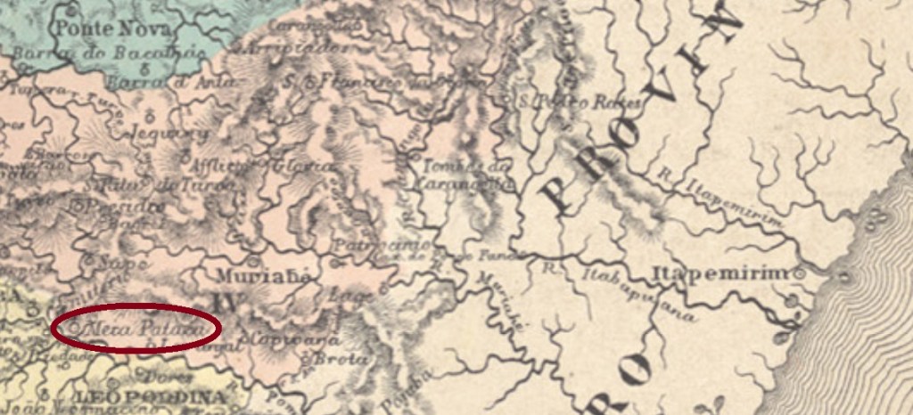
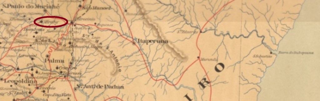
A pataca was an old Brazilian silver coin, about 320 réis worth. So had a Meia Pataca (half pataca) the approximate value of 160 réis. The freguesia of Meia Pataca was founded in June 1859 near the west bank of the Muriaé River in the municipality of Cataguazes, round 180 km southeast of the province capital Ouro Preto. The locality was given in October 1883 the name of Santo Antonio do Muriahé, but barely 20 years later it was renamed Mirahy and became an own municipality in September 1923. This tupi word shall mean swamp.
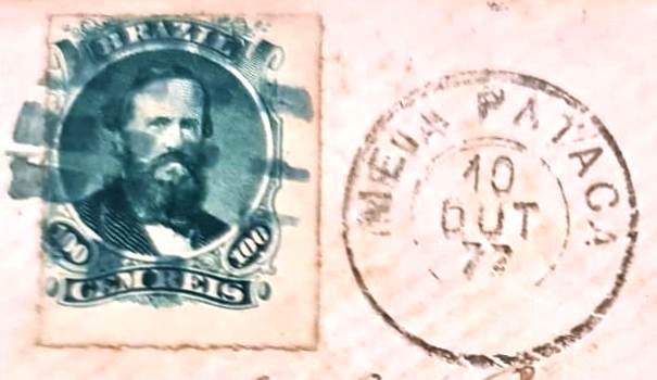
According to Paula Sobrinho (História Postal de Minas Gerais, Belo Horizonte, 1997), the local post office was created in October 1881. In the meantime, however, a letter dated October 1877 has turned up with the philatelist Constantino Papazoglu, bearing both a postmark with MEIA PATACA and a mute postmark:
1877 (Papazoglu)
This post office therefore had an earlier period of operation, the dates of which have yet to be discovered. Two later postmarks are already known: SMG-3005a (Coll. José A. Junges) has a double circle with the inscription S. ANTONIO DO MURIAHÉ above and a diamond ornament below, formed by four small diamonds. Dates at the centre from 1885-1886. SMG-3005b (Coll. José A. Junges) has between both circles the inscriptions S. ANTo. DE MURIAHÉ above and (MINAS) below. Dates at the centre between 1891 and 1894.
Mappa de Minas Geraes, 1910
Textaktualisierung am 27. Juli 2023
Andere Namen: Meia Pataca (1859), Mirahy (1903)
Eine Pataca war eine alte brasilianische Silbermünze, etwa 320 Réis wert. Dadurch schlug eine Meia Pataca (halbe Pataca) mit ca. 160 Réis zu Buche. Die Freguesia von Meia Pataca wurde im Juni 1859 nah am Westufer des Flusses Muriaé im Município von Cataguazes gegründet und lag knapp 180 km südöstlich der Provinzhauptstadt Ouro Preto entfernt. Die Ortschaft bekam im Oktober 1883 den zivilisierten Namen Santo Antonio do Muriahé. Dieser durfte aber nicht sehr beliebt gewesen sein, da der Ort knapp 20 Jahre später zu Mirahy umbenannt wurde. Das Tupi-Wort bedeutet Sumpf, und Mirahy ist seit September 1923 ein selbständiger Município.
Laut Paula Sobrinho (História Postal de Minas Gerais, Belo Horizonte, 1997) gibt es dort ein Postamt seit Oktober 1881. Inzwischen ist jedoch ein Brief vom Oktober 1877 bei dem Philatelisten Constantino Papazoglu aufgetaucht, der sowohl einen Poststempel mit MEIA PATACA als auch einen stummen Stempel trägt:
1877 (Papazoglu)
Dieses Postamt hatte also eine frühere Betriebsperiode, deren Daten noch zu entdecken sind. Zwei spätere Poststempel sind bereits bekannt:
SMG-3005a (Samml. José A. Junges) hat einen Doppelkreis mit der Inschrift S. ANTONIO DO MURIAHÉ oben und einem Ornament in Rautenform unten, das aus vier kleinen Rauten besteht. Daten in der Mitte aus dem Zeitraum 1885-1886. SMG-3005b (Samml. José A. Junges) hat zwischen den Kreisen die Inschriften S. ANTo. DE MURIAHÉ oben und (MINAS) unten. Die inneren Daten stammen von 1891 bis 1894.
See also Inhaúma I (R. Koester: Carimbologia XXII)
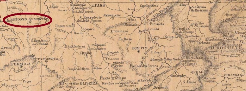
Santo Antonio do Monte in the Minas province was since May 1854 a district in the municipality of Formiga, situated ca. 250 km west of the capital Ouro Preto. It ascended five years later to a villa in own municipality, but lost this status in November 1865, returning to the district condition. In September 1870 the villa was restored and in November 1875 it was made a town, which between October 1885 and April 1899 was called Inhaúma. The common meaning for this tupi word would be a variant to anhuma, a South American bird (Anhima cornuta, Linnaeus, 1766) also called horned screamer.
Siehe auch Inhaúma I (R. Koester: Carimbologia XXII)
Santo Antonio do Monte in der Provinz Minas war ab Mai 1854 ein Distrikt des Município von Formiga, der ca. 250 km westlich der Hauptstadt Ouro Preto entfernt lag. Fünf Jahre später stieg er zur Villa im eigenen Município auf, verlor aber diesen Status im November 1865 und kehrte unter der Zuständigkeit von Formiga zurück. Bereits im September 1870 wurde der Ort wieder zur Villa ernannt und im November 1875 zur Stadt. Zwischen Oktober 1885 und April 1899 hieß diese Stadt Inhaúma. Die übliche Bedeutung dieses Worts aus der Tupi-Sprache wäre eine Variante zu anhuma: der südamerikanische Hornwehrvogel (Anhima cornuta, Linnaeus, 1766).
Nova Monteiro (Administrações e Agencias Postaes do Brasil Imperio, in Brasil Filatelico/RJ, 1934-5; Reprint SPP 1994-1999) behauptet, das örtliche Postamt entstand im Dezember 1863, dennoch sowohl R. Koester als auch Paula Sobrinho (História Postal de Minas Gerais, Belo Horizonte, 1997) und das Verzeichnis der kaiserlichen Postämter (Tabella das Agencias do Correio do Imperio) von 1885 schreiben dafür den März 1864. Ein Stempel der Kaiserzeit wurde gesehen, wohl nicht der früheste. SMG-3490b (Samml. José A. Junges) hat einen Doppelkreis mit der Inschrift S. A. DO MONTE. Da die Daten in der Mitte aus dem Zeitraum 1879-1889 stammen, wurde der Stempel auch nach dem Wechsel des Ortsnamens weiter verwendet.
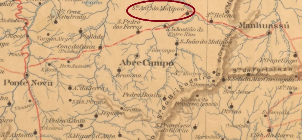
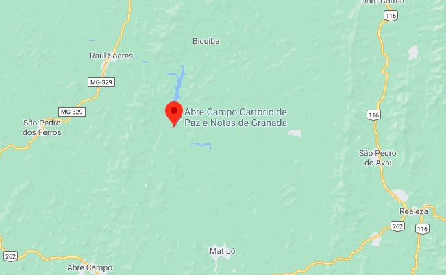
The name Matipoó derives from the tupi-guarani and supposedly means bursting maize. The small river Matipó (barely 150 km long) is an affluent to the Rio Doce, which in January 1880 gave the name to the parish of Santo Antonio on its the south bank, situated over 150 km east of the provincial capital Ouro Preto. It has belonged from then on to the municipality of Abre Campo (“Open the Field”) and since December 1943 the district is called Granada.
According to Paula Sobrinho (História Postal de Minas Gerais, Belo Horizonte, 1997), the local post office was created in July 1882. One imperial cancel was found: SMG-2970a (Coll. José A. Junges) has a double circle with the inscriptions S. ANT. DO MATIPOÓ above and (MINAS) below. Dates at the centre from 1889 until 1894.
GoogleMaps
Anderer Name: Granada (1943)
Siehe also Matipóo (RK: Carimbologia XXVII)
Der Name Matipoó hat einen Tupi-guarani-Ursprung und bedeutet angeblich platzender Mais. Vielleicht krachte der kleiner Fluss Matipó (knapp 150 km lang) Matipó wie platzende Maiskörner, bevor er in den Rio Doce mündete. Nach dem Matipó wurde die Pfarrei in Ehren von Santo Antonio im Januar 1880 gegründet. Diese lag am Südufer, über 150 km östlich der Provinzhauptstadt Ouro Preto entfernt. Die Pfarrei gehörte dem Município von Abre Campo (“Öffne das Feld”), und seit Dezember 1943 trägt der Distrikt den Namen Granada.
Laut Paula Sobrinho (História Postal de Minas Gerais, Belo Horizonte, 1997) gibt es dort ein Postamt seit Juli 1882. Ein Stempel der Kaiserzeit ist bekannt: SMG-2970a (Samml. José A. Junges) hat einen Doppelkreis mit den Inschriften S. ANT. DO MATIPOÓ oben und (MINAS) unten. Daten in der Mitte von 1889 bis 1894.
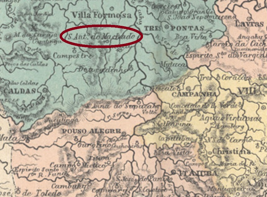
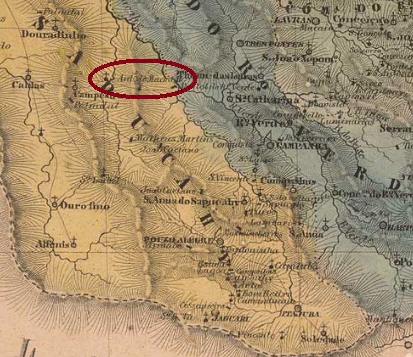
The district of Santo Antonio do Machado was created in July 1857 in the municipality of Alfenas, situated on the west bank of the Machado River, over 400 km southwest of the provincial capital Ouro Preto. The name derivates supposedly from an old farmer family of the region. The locality obtained the political autonomy as a villa in November 1880 and was elevated to a town in September 1923, under the simplified name of Machado.
Both Nova Monteiro (Administrações e Agencias Postaes do Brasil Imperio, in Brasil Filatelico/RJ, 1934-5; Reprint SPP 1994-1999) and Paul Sobrinho (História Postal de Minas Gerais, Belo Horizonte, 1997) state that the local post office was created in July 1864. Two imperial cancels have been found, which are most probably not the oldest ones. SMG-3035b (Coll. José A. Junges) has a double circle with the inscription S.A. DO MACHADO. The sole example is dated 1886 at the centre. SMG-3035c (Coll. José A. Junges) bears within the double circle the inscriptions S. ANTo. DO MACHADO above and (MINAS) below. The dates at the centre come from the period 1889-1906.
Villiers de l’Ile Adam: Carta (…) da Provincia de Minas Geraes, 1849
Anderer Name: Machado (1923)
Der Distrikt von Santo Antonio do Machado wurde im Juli 1857 im Município von Alfenas gegründet und lag am Westufer des Flusses Machado, über 400 km südwestlich der Provinzhauptstadt Ouro Preto. Der Name stammt vermutlich aus einem alten Stammesgeschlecht von Großgrundbesitzern der Region. Die Ortschaft erhielt die politische Selbständigkeit als eine Villa im November 1880 und stieg – unter dem vereinfachten Namen Machado – zu einer Stadt im September 1923 auf.
Sowohl Nova Monteiro (Administrações e Agencias Postaes do Brasil Imperio, in Brasil Filatelico/RJ, 1934-5; Reprint SPP 1994-1999) als auch Paul Sobrinho (História Postal de Minas Gerais, Belo Horizonte, 1997) sind sich darüber einig, dass das örtliche Postamt im Juli 1864 entstanden ist. Zwei Stempel aus der Kaiserzeit waren zu finden, die allerdings wohl nicht die ältesten sind. SMG-3035b (Samml. José A. Junges) hat einen Doppelkreis mit der Inschrift S.A. DO MACHADO. Das einzig vorhandene Exemplar ist mit 1886 in der Mitte datiert. SMG-3035c (Samml. José A. Junges) trägt zwischen den Kreisen die Inschriften S. ANTo. DO MACHADO oben und (MINAS) unten. Die Daten in der Mitte entstammen dem Zeitraum 1889-1906.
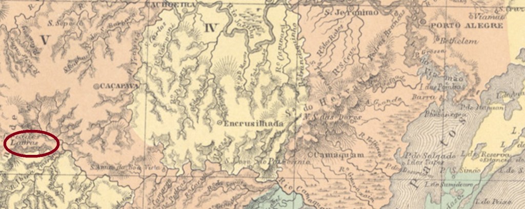
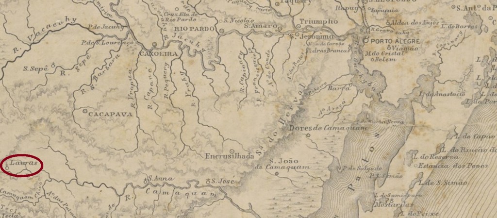
Santo Antonio de Lavras was since November 1847 a district in the municipality of Cassapava, situated over 300 km southwest of the provincial capital Porto Alegre. In May 1882 it ascended to a villa in own municipality, which since December 1944 is called Lavras do Sul.
The date of creation of the local post office is unknown until now, but it must have taken place between 1868 and 1878, for the earliest available cancels are dated May and June 1878. SRS-0545a (Coll. José A. Junges) has a double circle with the inscription S.A. DE LAVRAS and dates inside.
Provincia de São Pedro do Rio Grande, 1877
Anderer Name: Lavras do Sul (1944)
Siehe auch Lavras/RS (Koester: Carimbologia XXVI)
Santo Antonio de Lavras war ab November 1847 ein Distrikt im Município von Cassapava, der über 300 km südwestlich der Provinzhauptstadt Porto Alegre entfernt lag. Im Mai 1882 steig er zur Villa im eigenen Município auf. Dieser heißt seit Dezember 1944 Lavras do Sul.
Bisher ist uns nicht gelungen, das Entstehungsjahr des dortigen Postamts zu ermitteln. Das muss aber zwischen 1868 und 1878 stattgefunden haben, denn die früheste Stempel sind mit Mai und Juni 1878 datiert. SRS-0545a (Samml. José A. Junges) hat einen Doppelkreis mit der Inschrift S.A. DE LAVRAS und Datum in der Mitte.
Other names: Retiro da Lagoa, Santo Antonio da Lagoa Fria, Lagoa, Lagoa Bonita (1943)
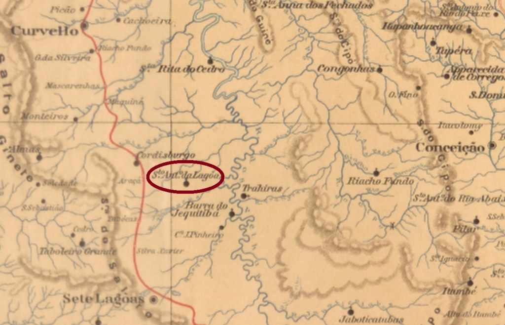
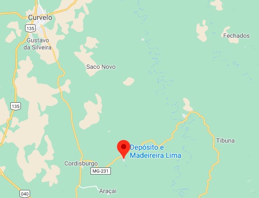
Santo Antonio da Lagoa was from November 1880 on a freguesia in the municipality of Curvello, situated over 200 km northwest of the provincial capital Ouro Preto. It originated from the ancient district of Monteiros and had the headquarters in the locality Retiro da Lagoa. In December 1938 it had the name altered to Lagoa as a district of Cordisburgo, and five years later it was given the actual district name of Lagoa Bonita.
According to Paula Sobrinho (História Postal de Minas Gerais, Belo Horizonte, 1997), the local post office originated in November 1881. One early cancel was found: SMG-2965a (Coll. José A. Junges) has a double circle with the inscription S. ANTONIO DA LAGOA. Both known examples have dates of 1890 inside.
Google Maps
Andere Namen: Retiro da Lagoa, Santo Antonio da Lagoa Fria, Lagoa, Lagoa Bonita (1943)
Santo Antonio da Lagoa war ab November 1880 eine Freguesia im Município von Curvello, die über 200 km nordwestlich der Provinzhauptstadt Ouro Preto lag und dessen Hauptsitz die Freguesia von Retiro da Lagoa war. Ursprünglich hieß der Distrikt Monteiros. Im Dezember 1938 wurde der Ortsname zu Lagoa als ein Distrikt von Cordisburgo umbenannt, und schon fünf Jahre später bekam die Ortschaft den aktuellen Namen Lagoa Bonita.
Laut Paula Sobrinho (História Postal de Minas Gerais, Belo Horizonte, 1997) gibt es dort ein Postamt seit November 1881. Ein früher Stempel wurde gefunden: SMG-2965a (Samml. José A. Junges) hat einen Doppelkreis mit der Inschrift S. ANTONIO DA LAGOA. Beide bisher gesichteten Exemplare haben Daten von 1890 in der Mitte.
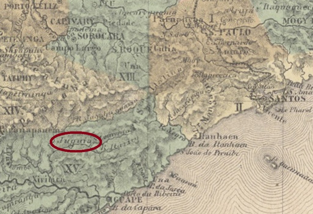
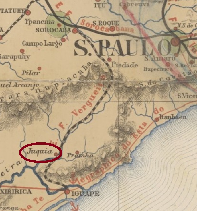
Santo Antonio do Juquiá was since April 1853 a freguesia in the municipality of Iguape, situated on the Juquiá River, over 150 km southwest of the province capital São Paulo. In November 1938 it switched to the municipality of Prainha and six years later, to Miracatu. Since December 1948 it is the municipality of Juquiá. This tupi-guarani word means allegedly dirty water.
No imperial cancel under the complete toponym has been found until now. For cancels featuring Juquiá see Koester’s Carimbologia XXV.
Provincia de São Paulo, 1886
Siehe auch Juquiá (R. Koester: Carimbologia XXV)
Santo Antonio do Juquiá war ab April 1853 eine freguesia im Município von Iguape, die am Fluss Juquiá lag, über 150 km südwestlich der Provinzhauptstadt São Paulo entfernt. Im November 1938 wechselte die Zuständigkeit zu Prainha, und sechs Jahre später, zu Miracatu. Seit Dezember 1948 ist es der Município von Juquiá. Das Wort der Tupi-guarani-Sprache soll angeblich schmutziges Gewässer bedeuten.
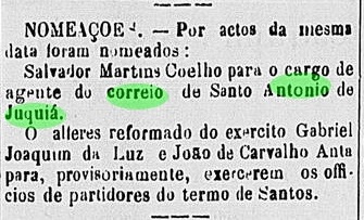
Laut Verzeichnis der kaiserlichen Postämter (Tabella das Agencias do Correio do Imperio) von 1885 stammt das örtliche Postamt aus dem Jahr 1881. Im Oktober des Jahres wurde bereits ein Postangestellter durch die Regionalpresse vorgestellt:
Correio Paulistano, 5. Oktober 1881
Kein Poststempel der Kaiserzeit wurde unter dem vollständigen Ortsnamen bisher gefunden. Für Stempel mit der Legende Juquiá siehe Koesters Carimbologia XXV.