Categories
Carimbologia S

Sant’Anna de Batataes, São Paulo (SSP-1898)

Atlas do Imperio do Brasil, 1868

Other names: Sant’Anna do Serrado, Ipuã (1944)

See also Sant’Anna dos Olhos d’Água (SSP-1900)

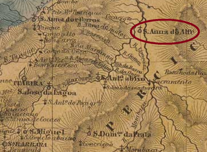
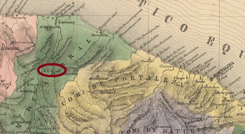
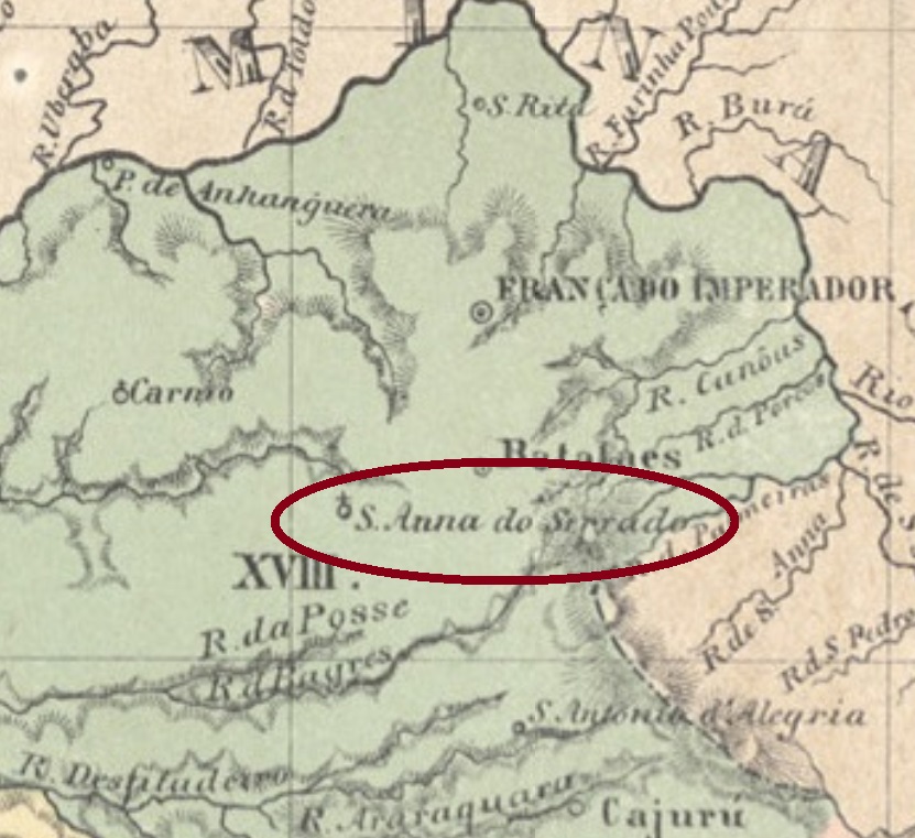
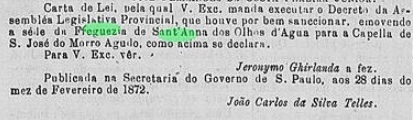
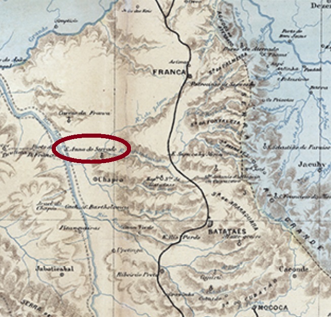
Sant’Anna de Batataes was an alias name to Sant’Anna dos Olhos d’Água, which was since April 1859 a freguesia of the municipality of Batataes, situated between the Sapucahy-Mirim and the Ipuã Rivers, over 400 km north of the provincial capital São Paulo. The detailed history of the village development until becoming Ipuã in 1944 will be described under Sant’Anna dos Olhos d’Água (SSP-1900). It is here important to point to the fact that in February 1872 the freguesia headquerters were transferred to São José do Morro Agudo:

Diario de São Paulo, June 2, 1872

Possibly as a compensation, three years later there was a mail route passing through the village of Sant’Anna de Batataes:

Correio Paulistano, August 21, 1875

Given that all other stops throughout this route had their own post offices, we can assume that at that time a post agency had been created under the toponym Sant’Anna de Batataes. This route was republished regularly in the São Paulo press until November 1877. After that, Sant’Anna de Batateas was not mentioned anymore, and the post office reopened only in January 1887, under Sant’Anna dos Olhos d‘Água. No imperial post cancel has appeared until now.

C. Rath: Mappa da Provincia de São Paulo, 1886

Andere Namen: Sant’Anna do Serrado, Ipuã (1944)

Siehe auch Sant’Anna dos Olhos d’Água (SSP-1900)

Sant’Anna de Batataes war eine andere Bezeichnung für die Ortschaft Sant’Anna dos Olhos d’Água, die seit April 1859 eine Freguesia im Município von Batataes war, und zwischen den Flüssen Sapucahy-Mirim und Ipuã, über 400 km nördlich der Provinzhauptstadt São Paulo entfernt lag. Die detaillierte Ortsgeschichte bis Ipuã (1944) wird unter Sant’Anna dos Olhos d’Água (SSP-1900) erzählt. Hier ist es aber wichtig zu betonen, dass im Februar 1872 der Hauptsitz der Freguesia nach São José do Morro Agudo verlegt wurde:

Diario de São Paulo, 2. Juni 1872

Möglicherweise als Kompensation dafür angedacht, wurde drei Jahre später in der Regionalpresse eine Postroute angekündigt, die durch den Ort Sant’Anna de Batataes fuhr:

Correio Paulistano, 21. August 1875

Da alle andere Haltestellen der Route ihre eigenen Postämter hatten, können wir davon ausgehen, dass zu diesem Zeitpunkt auch in Sant’Anna de Batataes eine Agentur existierte. Diese Route war fortan regelmäßig bis November 1877 in der Paulista-Presse zu lesen. Danach wurde Sant’Anna de Batataes nicht mehr erwähnt, und erst im Januar 1887 eröffnete ein Postamt – unter dem Ortsnamen Sant’Anna dos Olhos d’Água – wieder. Keine postalische Abstempelung von Sant’Anna de Batataes war bisher zu sehen.

Categories
Carimbologia S

Sant’Anna das Antas, Goiás (SGO-0200)

Photo: Bernard Dupont (CC-BY SA)

Other names: Sant’Anna d’Antas, Sant’Anna de Campos Ricos, Anápolis (1907)

Anta is the portuguese name for the South American tapir (Tapirus terrestris, Linnaeus, 1758), that must have been very common in the region, because it has named both the Rio das Antas and this locality. Formerly the district of Sant’Anna de Campos Ricos, it was created in June 1873 and belonged to the municipality of Meia Ponte (today: Pirenópolis), situated almost 200 km east of the former province capital Goyaz. In September 1887 it was elevated to the Villa of Sant’Anna das Antas, twenty years later the toponym changed to the actual Anápolis.

The local post office opened apparently by April 1888, since a press note announces a change in the regional mail route in order to serve this locality from then on:

Goyaz, April 27, 1888

One imperial cancel is known: SGO-0200a (Coll. Fuad Ferreira Fo.) has a double circle with the inscriptions S. ANNA DAS ANTAS above and (GOYAZ) below. The only found example is dated 1889 at the centre.

Carta da Republica dos Estados Unidos do Brazil, 1892

Andere Namen: Sant’Anna d’Antas, Sant’Anna de Campos Ricos, Anápolis (1907)

Anta ist das portugiesische Wort für den Südamerikanischen Tapir (Tapirus terrestris, Linnaeus, 1758), der in dieser Gegend sehr geläufig sein mußte, denn er gab seinen Namen sowohl dem Rio das Antas als auch diesem Ort. Dieser wurde im Juni 1873 als der Distrikt von Sant’Anna de Campos Ricos im Município von Meia Ponte (today: Pirenópolis) gegründet und lag fast 200 km östlich der ehemaligen Provinzhauptstadt Goyaz entfernt. Im September 1887 stieg er zur Villa von Sant’Anna das Antas auf, zwanzig Jahre später wechselte der Ortsname zum heutigen Anápolis.

Das örtliche Postamt eröffnete offenbar kurz vor April 1888, da eine Pressenotiz zu diesem Zeitpunkt einen Wechsel in der Postroute ankündigte, eben um diese Ortschaft fortan zu bedienen:

Goyaz, 27. April 1888

Ein Stempel der Kaiserzeit ist überliefert: SGO-0200a (Samml. Fuad Ferreira Fo.) hat einen Doppelkreis mit den Inschriften S. ANNA DAS ANTAS oben und (GOYAZ) unten. Das einzige gefundene Exemplar trägt ein Datum aus 1889 in der Mitte.

Categories
Carimbologia S

Sant’Anna do Alfié, Minas Gerais (SMG-2735)

Atlas do Imperio do Brasil, 1868

Sant’Anna do Alfié (or simply Alfié) was since April 1840 a district of the municipality of Santa Barbara, situated over 150 km northeast of the provincial capital Ouro Preto. In March 1890 it changed as a district of the newly founded municipality of São Domingos do Prata and has remained so until our days.

According to Paula Sobrinho (História Postal de Minas Gerais, Belo Horizonte, 1997), the local post office was created in March 1877. The only imperial cancel known to date is SMG-2735a (image from the internet): a double circle with the inscription SANT’ANNA DO ALFIÉ above and a diamond ornament below, which consists of four small diamonds. Dates at the centre come from the period 1886-1895.

Villiers de l’Ile Adam: Carta (…) da Provincia de Minas Geraes, 1849

Sant’Anna do Alfié (oder einfach Alfié) war seit April 1840 ein Distrikt des Município von Santa Barbara und lag über 150 km nordöstlich der Provinzhauptstadt Ouro Preto entfernt. Im März 1890 wechselte er als Distrikt des neu gegründeten Município von São Domingos do Prata, und dieser Status blieb bis heute.

Laut Paula Sobrinho (História Postal de Minas Gerais, Belo Horizonte, 1997) gibt es ein Postamt dort seit März 1877. Der einzig bisher gesehene Poststempel der Kaiserzeit ist SMG-2735a (Abb. aus dem Internet): ein Doppelkreis mit der Inschrift SANT’ANNA DO ALFIÉ oben und einem rautenförmigen Ornament unten, das aus vier kleinen Rauten besteht. Die Daten in der Mitte stammen aus dem Zeitraum 1886-1895.

Categories
Carimbologia S

Sant’Anna dos Alegres, Minas Gerais (SMG-2780)

Atlas do Imperio do Brasil, 1868

Other names: Alegres, João Pinheiro (1911)

Sant’Anna dos Alegres was since August 1813 a freguesia of the municipality of Paracatu, situated almost 500 km northwest of the old province capital Ouro Preto. A local legend says Alegre (=Happy) was the name of an ox that used to moo joyfully during the whole night and so named the entire village. Se non è vero, è ben trovato.

The freguesia ascended to a district in November 1873 and emancipated in August 1911 as the villa of João Pinheiro. The name is a tribute to João Pinheiro da Silva (1860-1908), who was twice president of the Minas Gerais state: in 1890 and from 1906 until his death.

According to Paula Sobrinho (História Postal de Minas Gerais, Belo Horizonte, 1997), the local post office was created in July 1882. One early cancel was found: SMG-2780a (Coll. Márcio Protzner) has a double circle with the inscription S. ANNA DOS ALEGRES above and a diamond ornament below, whose four sides are open. The unique example has a date of 1897 at the centre.

Villiers de l’Ile Adam: Carta (…) da Provincia de Minas Geraes

Andere Namen: Alegres, João Pinheiro (1911)

Sant’Anna dos Alegres war seit August 1813 eine Freguesia im Município von Paracatu, die fast 500 km nordwestlich der ehemaligen Provinzhauptstadt Ouro Preto entfernt lag. Einer Ortssage zufolge hieß Alegre (= fröhlich) ein Ochse, der gut und gerne durch die ganze Nacht gemuht und dadurch die gesamte Ortschaft geprägt hat. Se non è vero, è ben trovato.

Die Freguesia stieg im November 1873 zum Distrikt auf und wurde ein Município im August 1911, der Villa de João Pinheiro hieß. Der Name ist eine Hommage an João Pinheiro da Silva (1860-1908), der zweimal Präsident des Staates Minas Gerais war: 1890 und von 1906 bis zu seinem Tod.

Laut Paula Sobrinho (História Postal de Minas Gerais, Belo Horizonte, 1997) gibt es das örtliche Postamt seit Juli 1882. Ein früher Stempel war zu finden: SMG-2780a (Samml. Márcio Protzner) hat einen Doppelkreis mit der Inschrift S. ANNA DOS ALEGRES oben und einem rautenförmigen Ornament unten, dessen vier Seiten offen sind. Das einzige Exemplar trägt ein Datum von 1897 in der Mitte.

Categories
Carimbologia S

Sant’Anna da Água Boa, Minas Gerais (SMG-2605)

Mappa de Minas Geraes, 1910

Other names: São José da Água Boa, Água Boa (1953)

The former district of São José da Água Boa (at the good water) received in May 1877 the name from the brook on place, in the municipality of Minas Novas, and was situated over 400 km north of the provincial capital Ouro Preto. In October 1885 the toponym changed to Sant’Anna da Água Boa, in 1933 it became a district of Capelinha, and finally in December 1953 it emancipated policially as the municipality of Água Boa.

According to Paula Sobrinho (História Postal de Minas Gerais, Belo Horizonte, 1997) the local post office was created in September 1888. The only known early cancel does not mention Sant’Anna, but since Reinhold Koester hasn’t registered it, let’s introduce SMG-2605b (Coll. Márcio Protzner): a double circle with the inscriptions AGUA BOA above and (MINAS) below. The date at the centre shows the year 1900.

Raphael Lorenzeto de Abreu, CC-BY SA

Andere Namen: São José da Água Boa, Água Boa (1953)

Der ehemaliger Distrikt von São José da Água Boa (am guten Gewässer) erhielt im Mai 1877 seinen Namen vom kleinen Fluss vor Ort und lag im Município von Minas Novas, über 400 km nördlich der alten Provinzhauptstadt Ouro Preto entfernt. Im October 1885 änderte sich der Ortsname zu Sant’Anna da Água Boa, 1933 wurde daraus ein Distrikt von Capelinha, und schließlich im Dezember 1953 stieg die Ortschaft zum Município von Água Boa auf.

Laut Paula Sobrinho (História Postal de Minas Gerais, Belo Horizonte, 1997) entstand das örtliche Postamt im September 1888. Der bisher einzig bekannter früher Stempel erwähnt  Sant’Anna überhaupt nicht. Aber da Reinhold Koester ihn offenbar nicht kannte, stellen wir SMG-2605b (Samml. Márcio Protzner) hiermit vor: ein Doppelkreis mit den Inschriften AGUA BOA oben und (MINAS) unten. Das Datum in der Mitte zeigt bereits das Jahr 1900.

Categories
Carimbologia S

Sant’Anna (train station/Bahnhof EFMC), Rio de Janeiro (SRJ-1875)

Almanak Laemmert, 1892

Other names: Sant’Anna de Macabu, Cabiúnas

This Sant’Anna train station was inaugurated in ca. 1877 by the Estrada de Ferro de Macaé e Campos in the municipality of Macaé, ca. 200 km northeast of the imperial capital Rio de Janeiro. It was also called Sant’Anna de Macabu, after a small river in the surroundings, but this name has brought frequent confusion with Sant’Anna de Macacu (SRJ-1530). After 1892 the station name changed to Cabiúnas, which is a generical name for rosewood (Dalbergia sp.) in Brazil.

From 1890 on the rail line passed to the Estrada de Ferro Leopoldina, and from 1975 until operation end in 1996 it belonged to the Rede Ferroviária Federal S.A. Now the tracks are still there, but the station house has been demolished (estacoesferroviarias.com.br).

According to Paulo Novaes (agenciaspostais.com.br), the station post office opened ca.1877. But it must have closed soon, for its (re)creation was reported by the Rio press in September 1889:

Gazeta de Notícias, September 22, 1889

No imperial cancel has appeared until now.

Cabiúna (Photo: Anamaria Lana, Pinterest)

Andere Namen: Sant’Anna de Macabu, Cabiúnas

Dieser Bahnhof Sant’Anna wurde ca. 1877 durch die Estrada de Ferro de Macaé e Campos im Município von of Macaé eingeweiht und lag ca. 200 km nordöstlich der kaiserlichen Hauptstadt Rio de Janeiro entfernt. Er wurde auch Sant’Anna de Macabu genannt, nach einem kleinen Fluss der Umgebung, doch dieser Name brachte oft Verwechslung mit Sant’Anna de Macacu (SRJ-1530). Ab ca. 1892 hieß der Bahnhof offiziell Cabiúnas. Diese ist die allgemeine Bezeichnung für den brasilianischen Palisander (Dalbergia sp.).

Ab 1890 gehörte die Bahnlinie der Estrada de Ferro Leopoldina, von 1975 bis Betriebsende 1996 war sie im Besitz der Rede Ferroviária Federal S.A. Nun liegen die Schienen noch, aber das Bahnhofsgebäude wurde bereits abgerissen (estacoesferroviarias.com.br).

Laut Paulo Novaes (agenciaspostais.com.br) eröffnete das Bahnhofspostamt ca.1877. Dennoch wird er bald wieder geschlossen haben, denn die Rio-Presse berichtet über eine (Wieder)eröffnung im September 1889:

Gazeta de Noticias, 22. September 1889

Kein Poststempel aus der Kaiserzeit war bisher zu identifizieren.

Categories
Carimbologia S

Sant’Anna (train station/Bahnhof EFDPII), Rio de Janeiro (SRJ-1870)

Estrada de Ferro Central do Brasil 1890

Other names: Santanésia, Santana da Barra

See also Sant’Anna do Pirahy (SRJ-2365)

This Sant’Anna train station was built in August 1864 by the Estrada de Ferro D. Pedro II (EFDPII), situated in the municipality of Pirahy, round 120 km northwest of the imperial capital Rio de Janeiro. The rail line passed to the Estrada de Ferro Central do Brasil in 1889 and to the Rede Ferroviária Federal S.A. in 1975, which ended activities in 1996. The station itself was renamed Santanésia in the fourties, and Santana da Barra around 1987. Now the tracks are still there, but the station house is an abandoned ruin (estacoesferroviarias.com.br).

According to Nova Monteiro (Administrações e Agencias Postaes do Brasil Imperio, in Brasil Filatelico/RJ, 1934-5; Reprint SPP 1994-1999), the station post office opened as soon as September 1864. The earliest cancel, SRJ-1870a, was used at least until 1885, having been already presented by Paulo Ayres (Catálogo de Carimbos Brasil-Império, S. Paulo, 1937, 1942) under #1444:

SRJ-1870a, P.Ayres # 1444

It was followed by SRJ-1870b (Coll. Karlheinz Wittig): a double circle with the inscriptions EST. DE STA ANNA above and (E.F.D.P.2º) below. The dates at the centre were found for the period 1884-1889.

For imperial cancels from this locality before 1864 see Sant’Anna do Pirahy (SRJ-2365).

In 1999 (Photo: José Emilio Buzelin, apud estacoesferroviarias.com.br)

Andere Namen: Santanésia, Santana da Barra

Siehe auch Sant’Anna do Pirahy (SRJ-2365)

Dieser Bahnhof Sant’Anna wurde im August 1864 durch die Estrada de Ferro D. Pedro II (EFDPII) eingeweiht und lag im Município von Pirahy, rund 120 km nordwestlich der kaiserlichen Hauptstadt Rio de Janeiro entfernt. Die Bahnlinie gehörte ab 1889 der Estrada de Ferro Central do Brasil und ab 1975 bis zum Betriebsende im Jahr 1996 der Rede Ferroviária Federal S.A.. Der Bahnhof selber wurde zweimal umgetauft: er hieß Santanésia in den 40er Jahren und Santana da Barra ab ca. 1987. Nun sind die Schienen noch da, aber das Bahnhofsgebäude ist eine verlassene Ruine (estacoesferroviarias.com.br).

Laut Nova Monteiro (Administrações e Agencias Postaes do Brasil Imperio, in Brasil Filatelico/RJ, 1934-5; Reprint SPP 1994-1999) eröffnete das Bahnhofspostamt bereits im September 1864. Der früheste Stempel, SRJ-1870a, wurde mindestens bis 1885 gebraucht und wurde schon durch Paulo Ayres (Catálogo de Carimbos Brasil-Império, S. Paulo, 1937, 1942) unter Nr. 1444 vorgestellt:

SRJ-1870a, P. Ayres Nr. 1444

Ihm folgte SRJ-1870b (Samml. Karlheinz Wittig): ein Doppelkreis mit den Inschriften EST. DE STA ANNA oben und (E.F.D.P.2º) unten. Die Daten in der Mitte wurden innerhalb des Zeitraums 1884-1889 ermittelt.

Ein Poststempel dieser Ortschaft vor 1864 ist unter Sant’Anna do Pirahy (SRJ-2365) zu finden.

Categories
Carimbologia S

Sant’Anna, Ceará (SCE-0310)

Atlas do Imperio do Brasil, 1868

Other names: Licânia, Santana do Acaraú (1951)

We now reach the big family of the Sant’Anna post offices in Imperial Brazil. The meeting start introduces Sant’Anna in Ceará, which was since August 1848 a district of the municipality of Acaraú, situated on the east bank of the Acaraú River, over 250 km west of the province capital Fortaleza. In November 1862 it was elevated to the villa of Sant’Anna do Acaraú, a name that was simplified to Sant’Anna six years later. It was declared a town in August 1876, which was renamed Licânia in December 1943. This name was certainly not popular, because the old toponym Santana do Acaraú returned definitively in November 1951.

According to Nova Monteiro (Administrações e Agencias Postaes do Brasil Imperio, in Brasil Filatelico/RJ, 1934-5; Reprint SPP 1994-1999), the local post office was created in August 1866. Just one early cancel was found, which can be already republican, for it is dated 1897. SCE-0301b (Coll. José A. Junges) has a double circle with the inscriptions SANT’ANNA above and (CEARÁ) below, dated at the centre.

Villiers de l’ile Adam: Carta (…) da Provincia do Ceará, 1849

Andere Namen: Licânia, Santana do Acaraú (1951)

Nun erreichen wir die große Familie der Sant’Anna-Postämter im kaiserlichen Brasilien. Den Beginn macht die Ortschaft Sant’Anna in Ceará, die seit August 1848 ein Distrikt im Município von Acaraú war und am Ostufer des Flusses Acaraú, über 250 km westlich der Provinzhauptsadt Fortaleza entfernt lag. Im November 1862 wurde daraus die Villa von Sant’Anna do Acaraú, ein Name, der sechs Jahre später auf Sant’Anna gekürzt wurde. Im August 1876 stieg Sant’Anna zur Stadt, die im Dezember 1943 zu Licânia umgetauft wurde. Diese Bezeichnung war bestimmt nicht gut angekommen, denn der alte Ortsname Santana do Acaraú kehrte schließlich im November 1951 zurück.

Laut Nova Monteiro (Administrações e Agencias Postaes do Brasil Imperio, in Brasil Filatelico/RJ, 1934-5; Reprint SPP 1994-1999) gibt es dort ein Postamt seit August 1866. Ein einziger früher Stempel war zu finden, der auch republikanisch sein könnte, da er 1897 datiert ist. SCE-0301b (Samml. José A. Junges) hat einen Doppelkreis mit den Inschriften SANT’ANNA oben und (CEARÁ) unten, in der Mitte datiert.

Categories
Carimbologia S

Santa Victoria, Rio Grande do Sul (SRS-0405)

Atlas do Imperio do Brasil, 1868

This Santa Victoria in Brazil’s far south was named originally Santa Victoria do Chuhy, after the brook that separates Brazil from Uruguay. It was since 1858 a district of the municipality of Rio Grande, situated 500 km southwest of the province capital Porto Alegre. In October 1872 it ascended to a villa, and was declared a town in December 1888. Since May 1874 it has the actual official name Santa Vitória do Palmar.

According to the Imperial Mail Register (Tabella das Agencias do Correio do Imperio) of 1885, the local post office was created in 1873, although there was a private courier service (diligencias) before that. Three imperial cancels are registered. SRS-0405a (Coll. José A. Junges) is certainly the oldest among them: a double circle with the inscriptions CORREIO above and DE S. VICTORIA below, with twigs in diamond form separating them. The only known example is dated September 1880 at the centre. SRS-0405b (Coll. José A. Junges) is by far more common: also a double circle, now with the inscription S. VICTORIA above and an ornament in clubs form below. It occurs in black and lilac, with dates at the centre between ca. 1883 and 1906. There is furthermore a mute cancel also in lilac (Coll. José A. Junges), found on an issue of 1884, which resembles Paulo Ayres (Catálogo de Carimbos Brasil-Império, S. Paulo, 1937, 1942) # 61:

Paulo Ayres #61 (JJ)
Mappa da Provincia de São Pedro do Rio Grande, 1877

Santa Victoria in Brasiliens südlichster Gegend hieß früher Santa Victoria do Chuhy, nach dem Bach, der Brasilien von Uruguay trennt. Es war seit 1858 ein Distrikt im Município von Rio Grande und lag 500 km südwestlich der Provinzhauptstadt Porto Alegre entfernt. Im Oktober 1872 steig es zur Villa auf und wurde eine Stadt im Dezember 1888, die seit Mai 1874 Santa Vitória do Palmar offiziell heißt.

Laut Verzeichnis der kaiserlichen Postämter (Tabella das Agencias do Correio do Imperio) von 1885 entstand 1873 das örtliche Postamt, obwohl es bereits früher einen privaten Kurierdienst per Kutsche (diligencias) gegeben hat. Drei Stempel der Kaiserzeit sind bekannt. SRS-0405a (Samml. José A. Junges) ist bestimmt davon der älteste: ein Doppelkreis mit den Inschriften CORREIO oben und DE S. VICTORIA unten, getrennt durch Zweige in Kreuzform. Das einzige vorhandene Exemplar trägt ein Datum vom September 1880 in der Mitte. SRS-0405b (Samml. José A. Junges) kommt viel häufiger vor: auch ein Doppelkreis, hier aber mit der Inschrift S. VICTORIA oben und einem Ornament in Kreuzform unten. Kommt in schwarz und lila vor, mit Daten in der Mitte zwischen ca. 1883 und 1906. Außerdem gibt es auch einen stummen Stempel, auch in lila (Samml. José A. Junges), der auf einer D. Pedro Ausgabe von 1884 aufzufinden war. Sieht Paulo Ayres’ (Catálogo de Carimbos Brasil-Império, S. Paulo, 1937, 1942) Nr. 61 sehr ähnlich:

P. Ayres Nr. 61 (JJ)

Categories
Carimbologia S

Santa Thereza de Valença, Rio de Janeiro (SRJ-0890)

Atlas do Imperio do Brasil, 1868

This freguesia of Santa Thereza was created in October 1855 in the municipality of Valença, situated almost 200 km north of the imperial capital Rio de Janeiro. In March 1890 it was elevated to a villa, and in December 1929, to a town. Since December 1943 the municipality is called Rio das Flores, although this river does not cross the locality.

According to Nova Monteiro (Administrações e Agencias Postaes do Brasil Imperio, in Brasil Filatelico/RJ, 1934-5; Reprint SPP 1994-1999) the local post office was created in February 1857. The first two postal cancels were already presented by Paulo Ayres (Catálogo de Carimbos Brasil-Império, S. Paulo, 1937, 1942) under #1482 and 1595 respectively. The oldest one, SRJ-0890a, was used from the beginning until at least 1866, when SRJ-0890b followed it:

SRJ-0890a-b (P.A. 1482 and 1595)

Ayres also shows a mute cancel from there, which often accompanied SRJ-0890b and circulated at least until 1877. It was given #21:

P.A. 21

SRJ-0890c (Coll. José A. Junges) has a double circle with the inscription S. T. DE VALENÇA above and the date at the centre. Copies found from 1880 until 1887. The last imperial cancel, SRJ-0890d (Coll. Karlheinz Wittig) also has a double circle, but here the inscription is S. THERESA DE VALENÇA, and there is an 8-leg star ornament below. Dates found for the period 1889-1899. From an internet auction there was also a mute cancel from this village, which has not been presented yet:

1866ff (EB)
Villers de l’Ile Adam: Carta (…) da Provincia do Rio de Janeiro, 1850

Diese Freguesia von Santa Thereza wurde im Oktober 1855 im Município von Valença gegründet und lag fast 200 km nördlich der kaiserlichen Hauptstadt Rio de Janeiro entfernt. Im März 1890 stieg sie zur Villa auf, die im Dezember 1929 eine Stadt wurde. Seit Dezember 1943 heißt der Município Rio das Flores, obwohl dieser namens gebende Fluss eher weiter weg vorbei fließt.

Laut Nova Monteiro (Administrações e Agencias Postaes do Brasil Imperio, in Brasil Filatelico/RJ, 1934-5; Reprint SPP 1994-1999) gibt es das örtliche Postamt seit Februar 1857. Die ersten beiden Stempel wurden bereits durch Paulo Ayres (Catálogo de Carimbos Brasil-Império, S. Paulo, 1937, 1942) unter Nr.1482 resp.1595 vorgestellt. Der älteste davon, SRJ-0890a, war in Gebrauch wohl von Beginn an bis mindestens 1866, als SRJ-0890b ihm folgte:

SRJ-0890a-b (P.A. 1482 und 1595)

Ayres zeigt auch einen stummen Stempel von dort, der oft mit SRJ-0890b anzutreffen ist und bis ca. 1877 gebraucht wurde. Es ist die Nr. 21:

P.A. 21

SRJ-0890c (Samml. José A. Junges) hat einen Doppelkreis mit der Inschrift S. T. DE VALENÇA oben und dem Datum in der Mitte. Die Exemplare sind aus den Jahren zwischen 1880 und 1887 zu finden. Der letzte Stempel der Kaiserzeit, SRJ-0890d (Samml. Karlheinz Wittig) hat auch einen Doppelkreis, aber hier liest man S. THERESA DE VALENÇA, und unten gibt es ein 8-zackiges Sternornament. Die Daten sind zwischen 1889-1899 zu finden. Aus einer Internetauktion war auch ein bisher unbekannter stummer Stempel für diesen Ort zu sehen, um 1866 benutzt:

Ca. 1866 ff (EB)